Landscapes of Sri Lanka
Regional landscapes in SL :
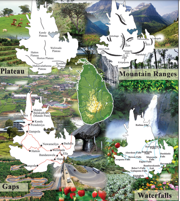
1.hilly region
In the lands located 300m above the mean sea level, a hill country landscape can be found
mainly found in both the Central Hills and Sabaragamuwa Hills of Sri Lanka
Main physical features :
Mountain ranges and plateaus
Samanala,Knuckle,Namunukulu,Kirigalpoththa,Piduruthalagala,Dolosbage,Haputhale
Plateaus
Kandy,Hatton,Welimada,Hortonplace,Koslanda,Mahawallathenna plateaus
Rivers flowing through valleys
Balana pass,Galagedara pass,Ginigathhena pass,Ella pass,Balakaduwa pass
Waterfalls
Laxapana,Baker’s fall,Bambarakanda fall,Ravana fall
Consists of a vegetation cover which is compatible with relief and climate.
The landscape linked to tea cultivation is unique to the Hill Country. Tea factories, large groups of workers, workers’ houses and bungalows, developed road systems as well as the cultural inheritance of the estate workers are some of the important features.
The network of roads that runs with many bends as a result of the relief pattern and houses built on the slopes are specific to the landscape of the Hill Country
Vegetable, fruit and flower cultivation done on a commercial basis and livestock farms associated with grasslands are found.
Both local and foreign tourists like to visit The Hill Country. Hence, tourist industry and features connected to it such as hotels, tourist bungalows and land areas allocated for recreational activities including sports activities are prominent features of this landscape
2.Dry Zone
Mainly, the dry zone landscape can be seen in North, North central, East and Southeast regions of the country
The base of the landscape of Dry Zone is set on the factors like severe drought, high temperature, uncertain and low rainfall and high evaporation
features of the physical landscape : Plains and residual hills scattered about, rivers that run dry during a particular period of the year, trees with tall trunks and hard heartwood
Grass, shrubs with thorny bushes that grow in arid climate that prevails at Mannar and Puttalam in the Northwestern region and Hambantota area in the Southeastern region of Sri Lanka too are specific features of this landscape.
Sigiriya, Dambulla, Ritigala, Kataragama etc. are several residual hills located in this region. According to the location and shape Sigiriya has been a fortress since the ancient times.
The tanks built by blocking the rivers that flow through the small ridges are also prominent in this landscape. Most of them are fed by rain water and the water of river Mahaweli. A large land area of the Dry Zone is utilized for paddy cultivation under irrigation. Rice mills and industries producing rice flour products have been established associated with the paddy cultivation
Planned farming settlements built with all the facilities for the people who were settled in farming colonies to cultivate the dry lands and paddy lands using the water of river Mahaweli are seen in the landscape of the Dry Zone.
Chena cultivation based on rain water is also a main feature of this zone. Chena with Danduweta (fence made of sticks), small hut and lands with crop cultivated on rain water is a gradually changing feature in the landscape of the Dry Zone.