Hydrogeology Final Exam Study Guide
Key
[[No idea whatsoever[[
{{Double check this{{
We’re solid on this
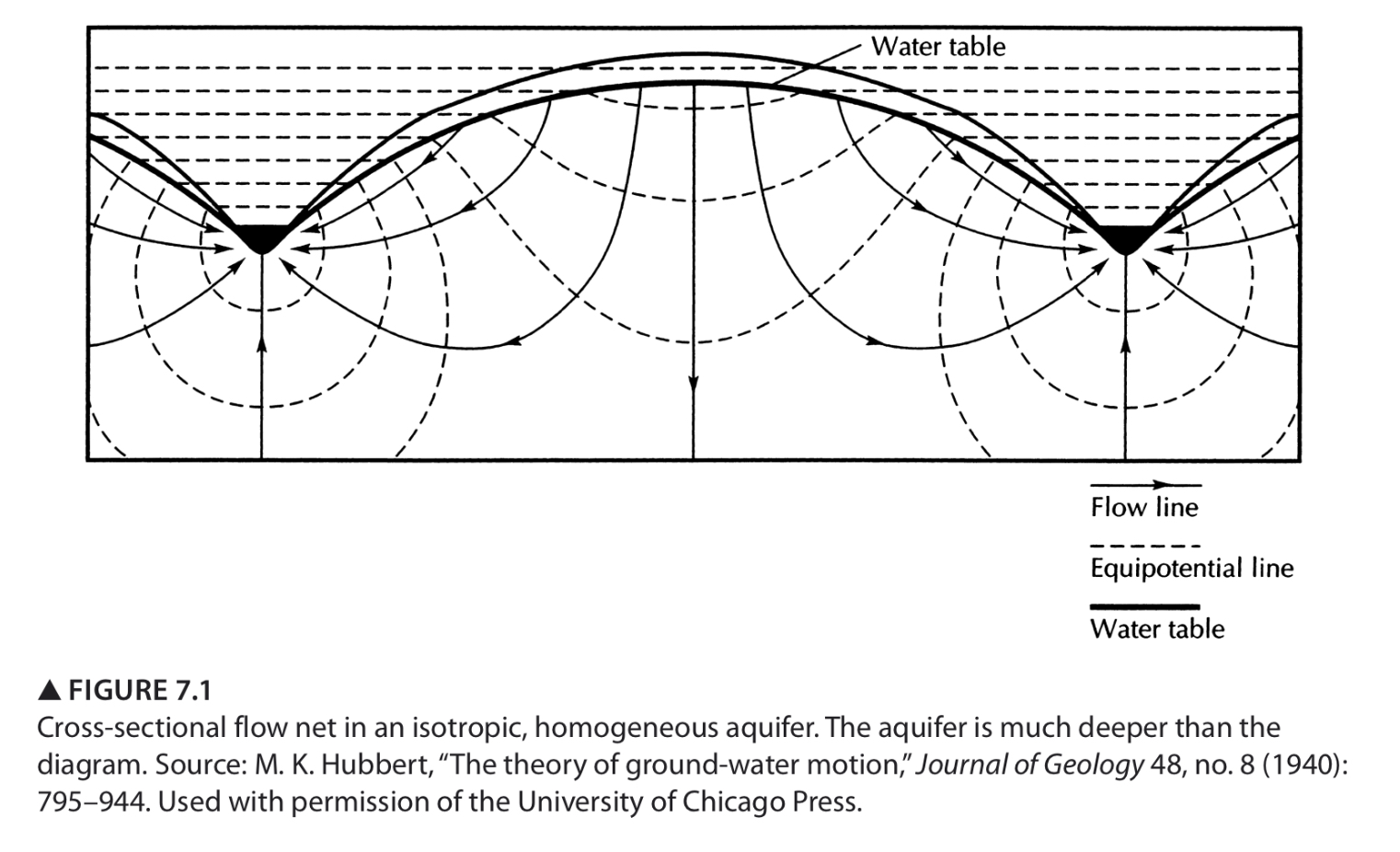
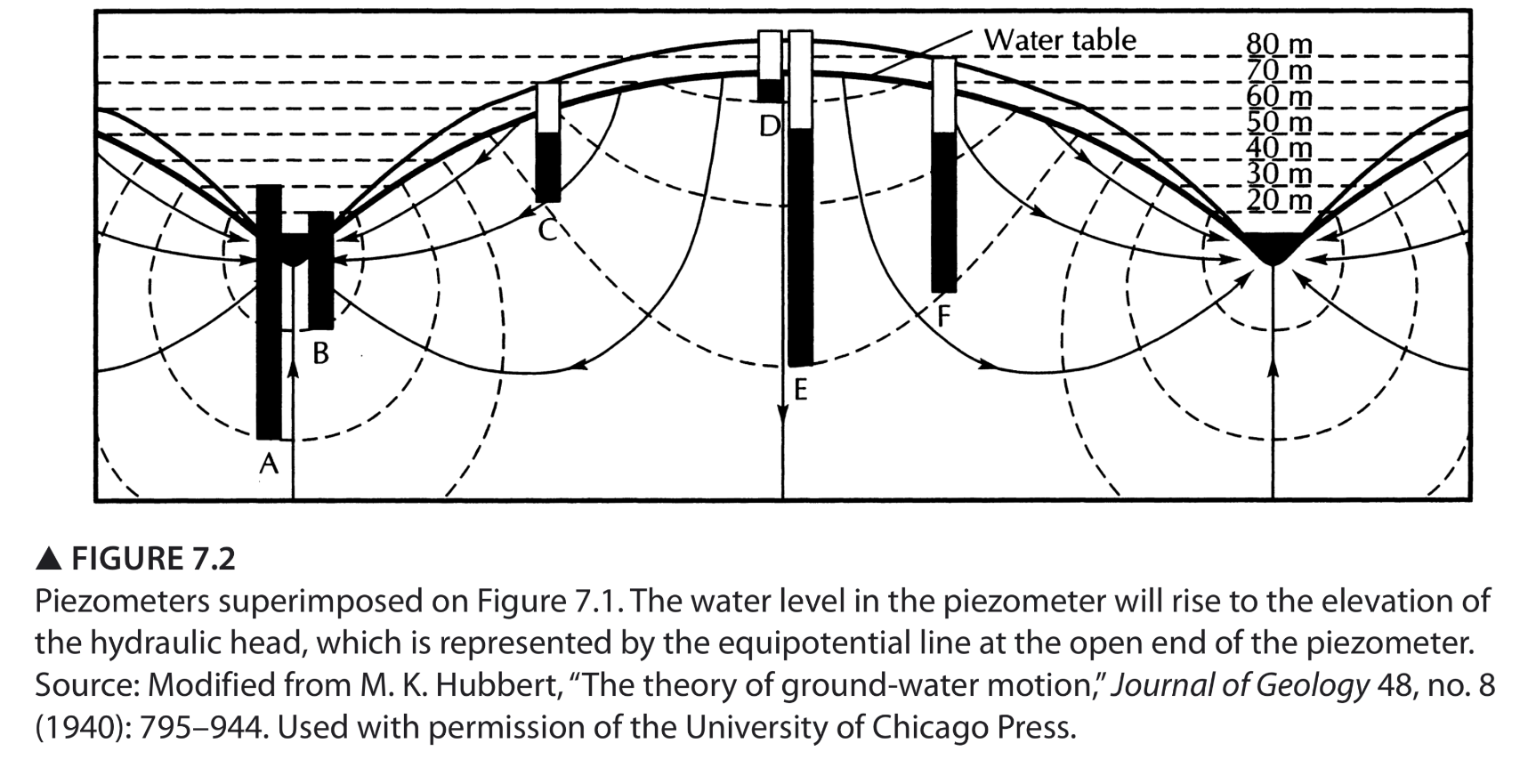
Regional Groundwater Flow
Recharge and Discharge Areas
Recharge areas in unconfined aquifers are usually in high places topographically and the water table is relatively deep compared to the land surface.
Discharge areas in unconfined aquifers are typically located in topographic lows and have a water table close to or at the land surface.
On a flow net flow lines tend to radiate from recharge areas and converge on discharge areas. This is not the case if the discharge area is really big, like a coastline.
Local, Intermediate, and Regional Flow Systems
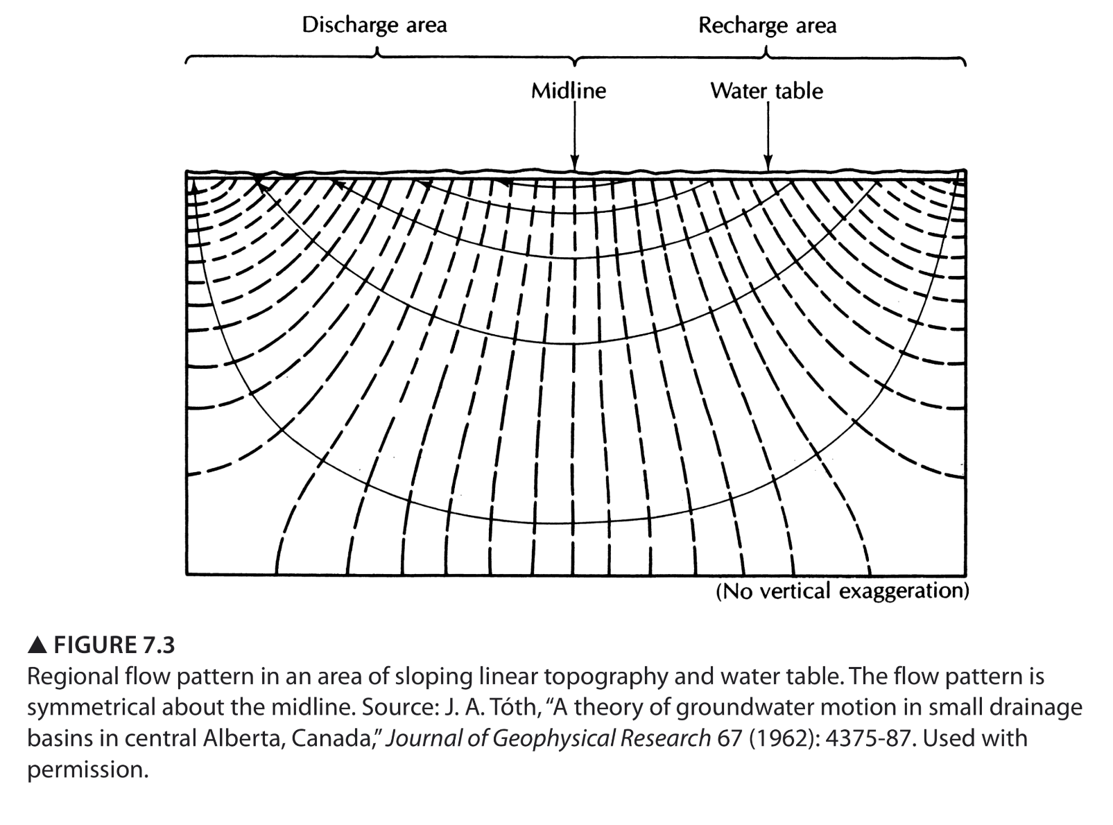
Figure 7.3 represents a basin where groundwater is primarily discharges through evapotranspiration or diffused springs, since flow lines do not converge on any point of discharge. The aquifer is assumed to be isotropic and homogenous.
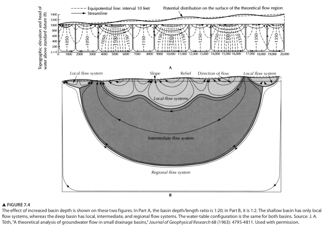
Figure 7.4 shows a basin with more realistic local, intermediate, and regional flow. The flow lines converge at and diverge from various discharge and recharge points.
Depending on the topography of the drainage basin and the geometry of the basin itself, flow systems may be regional; local; local and intermediate; or local, intermediate, and regional.
Local Groundwater Flow Systems
If surface topography have well-defined local relief, a series of local groundwater flow systems can form in humid regions because topographic relief causes undulations in the water table.
The more pronounced the relief of the undulating water table, the deeper local flow systems may extend.
A local flow system usually has a recharge area at a topographic high point and a discharge areas at an adjacent topographic low point.
Localized depressions in the ground surface and ponding related to this can cause concentrated areas of increased recharge.
Intermediate Groundwater Flow Systems
Intermediate flow systems are characterized as having at least one local flow system between their recharge and discharge areas.
Regional Groundwater Flow Systems
Regional flow systems have their recharge areas in the basin divide and their discharge areas at the valley bottom.
Stagnation Points
Stagnation points are a feature of complex flow systems where the directions and velocities in the flow field cancel each other out. They are found at the juncture of local and regional systems.
Hydraulic potential is higher at a stagnation point than the surrounding region.
Groundwater flow lines avoid the stagnation points.
Stagnation points can occur even if an aquifer is completely isotropic and homogenous.
Buried Lenses
What is the effect of a buried lens on flow lines and equipotential lines?
A high conductivity lens has equipotential lines that bow out around the lens and flow lines that converge towards the lens. A low conductivity lens has equipotential lines that bow inward to the lens and flow lines that avoid the lens.
Effect of Anisotropy
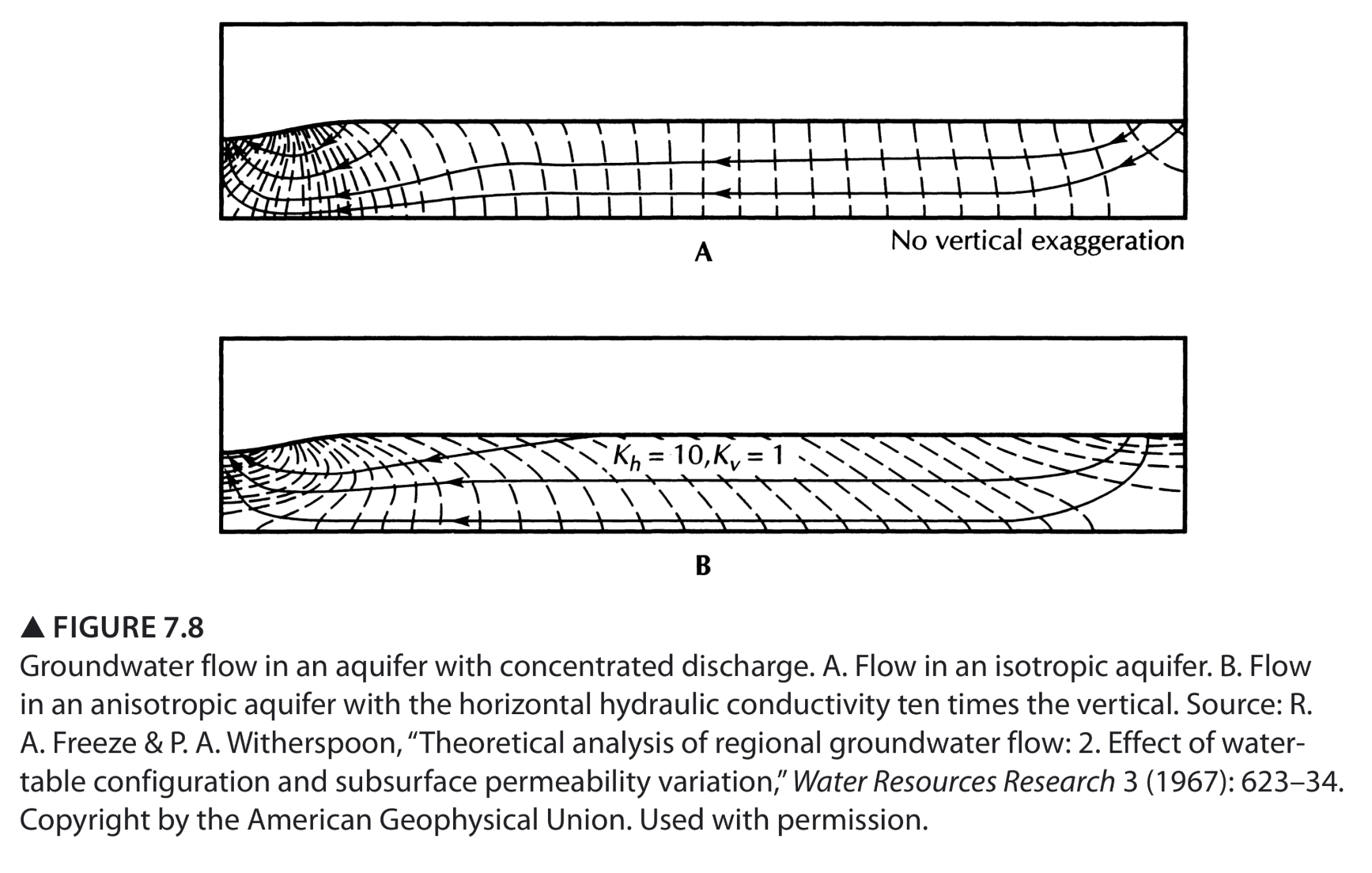
In anisotropic aquifers flow lines do not cross equipotential lines at right angles. As shown in figure 7.8, anisotropy causes bending in the equipotential lines. Additionally, vertical components of flow are more pronounced in an anisotropic aquifer than an isotropic one, with this being most pronounces in the extreme ends of the basin.
Underlying Layers of High and Low Conductivity
If a lower formation has a much higher hydraulic conductivity than a higher layer, the high K layer acts as a major flow path. Flow in the high K unit is nearly horizontal, other than the recharge and discharge areas. Flow lines tend to converge upon the high K layer.
For the opposite, a buried low K layer, the field looks a lot like an isotropic aquifer. Most flow is contained in the upper, higher conductivity layer.
Springs
Topographic low points are the easiest places for springs to form and many types of springs can be classified as depression springs, caused when the water table reaches the surface. The low point causes undulation in the water table and a local flow system is created with a spring where the water table intersects the ground surface.
Contact springs occur when permeable rock units overlie rocks that have a lower permiability. The difference in conductivity restricts downward movement in groundwater and transmits water horizontally towards hillslopes or cliff faces.
Fault springs are created by faulting that favors spring formation.
Sinkhole springs tend to occur around cave systems when a sinkhole causes the ground surface to make contact with a cavern shaft full of water.
Joint springs and fracture springs occur due to jointed or premeable fault zones in low-permeability rocks. Water moves through the rocks through fractures and springs form where the fractures intersect the land surface at low elevations.
Anions in Groundwater
{{Explain a typical evolution of anions in groundwater solution along long groundwater flow paths.{{
- {{Anions tend to sorb to broken edges of clay minerals as well as iron and aluminum oxides, while cations sorb to clay mineral surfaces. This suggests that in an aquifer with a clay confining layer or a base of clay there will be fewer cations and more anions as flow paths are followed and time progresses.{{
Slug Test
Slug tests work by inducing flow through sediment and are especially useful in areas of high hydraulic conductivity. A solid slug or water is dropped into a well and then calculations proceed using rising head methods. When the slug is removed a falling head method can be used to additionally evaluate the conductivity of a formation.
[[How does one use the Hvorslev or Bouwer and Rice methods? Why are these methods more complex than the equations used to determine K from a falling-head permeameter?[[
[[Given displacement data versus time for a slug test, be able to calculate hydraulic conductivity.[[
Unconsolidated Aquifers and Aquifers of Southwest Ohio
[[What are some different types of unconsolidated aquifers?[[
[[What are some different deposits in a glaciated terrain and how did they get there? What deposits produce potential aquifers and confining units?[[
[[Where does Oxford’s water come from and how did the aquifer get there?[[
[[What is till? What is outwash? How are they significant to water resources?[[
[[What are some different types of deposits in a tectonic valley and what kind of deposits might you look for when looking for potential aquifers?[[
Coastal Aquifers, Salt-Water Intrusion, and Groundwater Regions of the US
[[How does a Ghyben-Herzberg lens form? How does it relate to Archimedes’ Principle? What is the relationship between the height of the water table and the thickness of the lens?[[
[[Be able to apply equations that predict the position of the fresh-water salt-water interface and the length of the ocean discharge area beyond the shore.[[
[[What is up-coning?[[
When pumping occurs fresh water is drawn out and causes the salt-water fresh-water interface to shift by pulling water out of the aquifer that is then replaces with salt water.
[[How is it that one can find freshwater aquifers under islands that are miles off shore?[[
[[What groundwater region is Oxford in? Does the description in Fetter fit our area?[[
Groundwater Management and Sustainability
{{What is sustainability and sustainable development? What ethical concepts does it incorporate?{{
What are some problems associated with over-pumping of groundwater? How can these problems be alleviated?
- Some issues associated with over pumping of groundwater are salt water intrusion (particularly in coastal aquifers), land subsidence, and reducing surface water as the water table moves downward. These problems can be alleviated by creating a water budget, splitting water use between groundwater and surface water sources, and using less water.
{{What causes sinkholes and how are they related to groundwater pumping?{{
{{What is the High Plains aquifer system and the Ogallala formation? What is informative about the High Plains systems? What has gone on there the past 100 years or so?{{
What is meant by safe yield? How has this concept been traditionally applied? What is wrong with this traditional use? Besides sustaining groundwater for use byhous future generations of people, what are some other considerations?
- Most of this I cover below in the practice exam section. However, some other considerations when it comes to sustaining groundwater other than future generations are social concerns for people that rely on the same aquifer as well as ethical concerns regarding water rights and ensuring that everyone gets the water they need.
Explain the concept of capture. How does the source of water withdrawn from a well change over time?
- Below in the practice exam questions.
How would you go about determining the sustainable yield for an aquifer system? What data would you need? What would you need to investigate? How would you decide what is sustainable?
How might sustainable development of groundwater vary across different countries and why?
- Different countries may have different concepts of sustainable development based on the needs of that particular country as well as the hydrogeology of the area. For example, a country in the dry area with few to no active streams will likely be less concerned about maintaining base flow than those where streams are an important part of the ecosystem. Additionally, a country where there is large amounts of water insecurity will likely be more focused on getting citizens much needed water than preserving natural beauty of an area. There is also something to be said about the attitude of a society towards the natural beauty of the planet. If a society is less concerned about this then there may be less attention paid to negative ecological effects associated with the use of groundwater.
[[Be able to explain the plot showing the benefits and costs associated with consumptive vs. in stream use of water from a river.[[
Sources and Types of Groundwater Contamination
[[What is the difference between point and non point source pollution?[[
[[What is bioaccumulation and what contaminants does it pertain to?[[
[[What are sources of bacterial contamination of groundwater?[[
[[What are some groundwater contamination problems associated with landfills?[[
[[What are some hazardous waste products that have led to groundwater contamination?[[
[[What kinds of compounds are often found in contaminated groundwater in the US?[[
[[What are some health effects cause by toxic metals? Solvents? Pesticides?[[
Theory of Mass Transport
[[What is advection, diffusion, and dispersion?[[
[[Be able to interpret concentration profiles and breakthrough curves?[[
[[What does a breakthrough curve look like for a solute undergoing advection only?[[
What is mechanical dispersion? Why does it occur? How is it similar or not similar to chemical diffusion? How is it related to groundwater velocity?
- Mechanical dispersion is something I’m about to explain in very non-scientific terms. Essentially, most things are not moving through perfectly smooth tubes, so there is friction. When you’ve got friction in this tube that isn’t perfectly smooth, some things get caught up on the edges and thus get dispersed.
- This is different than chemical diffusion which I will also explain in less-than-scientific terms. When you’ve got two things mixed together (usually water and a solvent) they may not be perfectly mixed all the way together at first. Because our world is made of tiny atoms bouncing off of each other all the time, eventually everything has to even out, so the solute (the thing mixed into the water) bounces around until it’s even everywhere. Mechanical dispersion is less about everything becoming even and more about everything not moving at the same speed all at once.
- This brings me to groundwater velocity, ain’t that neat! All the water isn’t moving at the same pace due to mechanical dispersion. Thus, you can’t look at groundwater moving like it’s in a smooth tube, its in the dirt, dude!
[[What does a breakthrough curve look like that includes dispersion and/or sorption and/or degradation?[[
What causes sorption? What is a sorption isotherm and what practical information does it convey?
What is the relationship between sorption and retardation?
- {{I THINK sorption is caused by the tendency of cations to grip onto clay minerals and anions to silicate minerals, irons, and the edges of clay minerals. Essentially the things that are not water grab onto other things. A sorption isotherm tells you how likely a material is to apportion out into a solid or liquid form. A higher potential for something to sorb means that it’s going to slow down (aka retard).{{
[[What aquifer characteristics play the most important role in the sorption of organic compounds?[[
[[What aquifer properties do the degradation rate of organic compounds depend on?[[
[[What apparent effect does sorption have on soul transport? How do both sorption and degradation affect breakthrough curves and concentration profiles?[[
[[What do the curves of distance vs. time for the various contaminants injected at borden tell us about the processes occurring? Explain the implication of the fact that some of the curves are not straight lines and explain why this might occur.[[
NAPLs
[[What are DNAPLs and LNAPLs? What are the different phases of contaminants that you might find at a DNAPL or LNAPL spill site and where might you find them?[[
[[What are some special problems associated with both DNAPL and LNAPL-contaminated groundwater? Why are they so difficult to clean up?[[
[[What are the common DNAPL and LNAPL compounds and where do contamination events often take place?[[
Groundwater Restoration and Remediation
Know what the following methods refer to, how they work, and when you use them:
- [[Slurry wall[[
- [[Grout curtain[[
- Pump and treat (extraction)
- Pump and treat is exactly what it sounds like. Contaminated ground water is pumped out of the ground and treated to remove the contaminant.
- [[Air stripping[[
- [[Vapor extraction[[
- in situ bioremediation
- Introduction of microorganisms that break down a particular contaminant into the groundwater supply, and/or taking actions that encourage microorganisms to consume the contaminant. This is known as in situ bioremediation because it occurs when the water is still in the aquifer and it uses biological methods to break down the contaminant.
Explain the limitations of pump-and-treat and why bioremediation is usually necessary
- Initially pump-and-treat can be effective in remediating groundwater. However, as time goes on and pump-and-treat continues, less chemical is present to be pumped and treated, and thus more uncontaminated water is being pumped out and treated for a contaminant that is not present. Due to the fact that pump-and-treat becomes less effective as time goes on, it is usually necessary to implement in situ bioremediation, where microorganisms that eat the contaminant are added to the aquifer to further reduce contaminant levels when pump-and-treat is no longer effective.
Return to Woburn
What are the hydrogeological questions involved in deciding whether WR Grace or the Riley Tannery were responsible for the cases of childhood leukemia?
- Do either companies make a chemical that is known to cause childhood leukemia? Was this hypothetical chemical spilled? Was enough of the chemical spilled to be above safe levels at the well? How does this chemical interact with groundwater (i.e., how is sorbed, is it less dense or more dense than water, what is the status of homogeneity and isotropy in the aquifer, based on this how long would it take for a spill to reach a well)? How long does someone need to be exposed to the chemical in drinking water before they receive negative effects from it?
[[Explain all the ways that the travel time of TCE from the source areas to the wells was different for the mapping approach we did as a class exercise versus the 3-D model approach by Scott Bair and his students.[[
Practice Exam (without math questions)
[[Compare and contrast outwash and basal till in terms of how they are formed, their composition, and their hydrogeological properties and significance.[[
What is meant by safe yield? How has this concept been used historically? What is wrong with this traditional use? Begin with an explanation of the concept of capture.
- There have been many attempts to quantify how much water can be extracted from an aquifer “safely.” Thus the concept of safe yield has shifted over time to what we now know as sustainable yield.
- To understand safe yield and sustainable yield, an understanding of capture is necessary. An aquifer receives an amount of recharge as well as loses an amount of discharge during any period of time. When pumping occurs over a period of time, the source of the water pumped shifts as previously stored water is extracted from the aquifer. Over time, less of the water pumped comes from a change in storage and more of the water comes from a decrease in outflow or increase in inflow.
- Historically, capture was not well understood and some believed that if the amount of water pumped out of an aquifer was equal to the recharge then there would not be a depletion in the aquifer. However, we now know that this is incorrect. Water leaves aquifers in many ways, including discharge to streams and the ocean as well as evapotranspiration, and by removing all water that is thought to be recharged, we actually end up tapping in to stored water and moving from extracting water from a change in storage to extracting water and causing a decrease in outflow and increased induced infiltration.
[[Explain how the evolution of anion concentrations that you might find in large, regional flow systems. Be sure to convey why this might occur.[[
{{Why do we use anions like chloride or bromide to indicate groundwater velocity?{{
- {{Sorption? Because an anion doesn’t like to cling to clay so they’re more indicative of velocity than cations?{{
You are hired as a consultant by a company that has a gasoline spill on their property. You are asked to evaluate and determine whether the contamination is likely to move off the property. You have a budget of $50,000 and 6 months. Describe all the things you will measure and why.
{{Describe the limitations of pump-and-treat for remediation of DNAPL contamination of groundwater.{{
[[Describe some ways that we help facilitate in-situ bioremediation and briefly how they work.[[
{{Describe how and why the travel times for TCE traveling from WR Grace to Well H, as predicted by Scott Bair’s 3-D model, were so different from the travel times that we estimated using the water-table maps.{{
[[For both of the following remediation technologies describe their briefly how they work:[[
- [[air stripping tower[[
- [[floating pump[[
Essay Questions
You have been hired by a municipality to determine the sustainable yield for an aquifer system that they want to use as a water source? What data would you need? What would you need to investigate? How would you decide what is sustainable?
You have been hired as a consultant by Shell Oil to investigate a gasoline-distribution facility where they suspect that one of their tanks has leaked. The most immediate need is to figure out whether a contaminant plume is likely to flow beyond the property boundary. Make a list of all the things that you measure. For each, explain why you will measure it and how you will measure it.
Using all the information presented, discuss all the reasons that your travel-time predictions from your water-table map were so different from the Bair and Karakovnic modeling results.