Oceans and Coastal Margins
1. Introduction to Ocean Currents
Ocean Currents: surface ocean currents are caused by the influence of prevailing winds steadily blowing across the sea
Gyres Ocean Currents: the dominant pattern of surface ocean currents which is roughly a circular flow. This is clockwise in the northern hemisphere and anti-clockwise in the southern hemisphere due to the Coriolis Force due to the Earth’s rotation. The only expectation is the circumpolar current around Antarctica
Gulf Stream Ocean Currents: Narrow flowing current which is the return flow of westward piling water, caused by the circulation of gyres and the Earth’s rotation)
transports heat northwards and then eastwards across the North Atlantic
creates mild winters & cool summers in the British Isles
Transfer of Nutrients and Energy:
Nutrient Transfer due to Ocean Currents: eastern oceans experience upwelling currents, where the ocean currents move nutrient-rich cold water from the ocean flow to the surface
Energy Transfer due to Ocean Currents: Warm currents from regions near the equator raise the temperature of the polar area, while cold currents may reduce summer temperature when the wind blows from sea to land
Specific Heat Capacity: the amount of energy needed to raise the temperature
Takes more energy to heat water than land
Coastal regions are cold during the day and mild at night
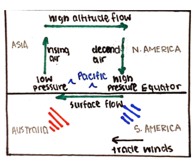
The Pacific Ocean
Two atmospheric states: are warm surface water in the west and cold surface water in the east (and vice versa). Warm surfaces cause low pressure, and as air blows from high pressure to low pressure, it causes a movement of water from colder areas to warmer areas
Ocean Conveyor Belt/Thermohaline Circulation (THC): a global thermohaline circulation driven by the formation and sinking of deep water and responsible for a large flow of upper ocean water
Thermocline: the boundary between 200-800m below which the surface waters do not mix with deeper layers; region marked by rapid discrete in temp as depth increases
Halocline (salinity) and Pycnocline (water density): both increase with increasing depth.
Halocline exists in the same depth as thermocline
Salinity rapidly increases and temp decreases, which leads increase in water density
marked by proc line
El Nino vs La Nina:
El Niño: a reversal of the normal atmospheric circulation in the southern Pacific Ocean, beginning arm water and low pressure to the eastern Pacific, and cool water and high pressure to the western Pacific
Occurs once every 2-10 years and lasts 12-18 months
La Niña: intensification of normal atmospheric process
The cold current that flows from the east across the equatorial Pacific Ocean
Occurs when low pressure in the western Pacific becomes even lower


Hurricanes:
Hurricanes (Tropical Cyclones): low-pressure systems; high-intensity rainfall, strong winds, & heavy waves (flooding & mudslides).
Originate from moist, tropical seas; erratic path; winds spiral rapidly around the calm area (eye); pressure contrast = strong gale-force winds.
Move excess heat from low latitudes to higher latitudes; begin as small-scale tropical depressions (low pressure, warm air rises).
Sea = temp. above 27°C and a depth of 60 m; low-pressure area far from the equator (Coriolis force rotates rising air mass); unstable conditions.
Saffir-Simpson scale = assign hurricane to 1 of 5 categories of potential disaster; based on wind intensity; formed in Atlantic and Pacific
Case Study:
Typhoon Haiyan, Philippines
winds of 314 km/hr
10 000 ppl killed & buildings were destroyed
sea waters rise 6 m
World Food Programme = $2 million in aid
economic cost = $15 billion (many countries pledged aid)
vulnerable community (no savings)
Ocean Role and Acidification:
Ocean Acidification: freshwater = pH of 7 & surface seawater = 8.2 (dropped to 8.1) ; absorption of CO2 by oceans ; 0.1 difference = inc. of 30%
Absorbed 50% extra CO2 during the industrial age; anthropogenic causes (human actions); threatened species (fisheries & coral reefs).
30% of human-made carbon absorbed by oceans; reacts and turns into carbonic acid - reducing calcification of organisms (growth rate Dec. 14%).
Pacific coast = failure of commercial oyster; Great Barrier Reef = coral bleaching; Poles / high latitudes = shellfish (pteropod) reduction
Oceans as a Source and Store of Carbon Dioxide: largest CO2 sink (90% of carbon); carbon on ocean floor lifted (thermohaline circulation) = source.
Cold glacial phases = atmospheric CO2 decreased, stored in oceans ; Warm interglacials = CO2 released from oceans (inc. atmospheric CO2).
CO2 reservoirs = fossil fuels, atmosphere, & oceans ; carbon cycle (photosynthesis produce CO2 & released by volcanic activity, long timescale)
2. Interactions Between Oceans and Coastal Places
Coastal Environments: influenced & shaped by physical and human processes
Lithology Properties (rock); Geological Structure (concordant coastline = geological strata is parallel to the coastline, discordant = perpendicular);
Processes (erosion, deposition);
Sea-Level Changes (interact w/ processes, advancing/retreating coastlines);
Human Impacts;
Ecosystem Type
Waves: wind blowing over the sea surface, tides, or earthquakes (tsunamis); controlled by wind strength & duration, the distance of open water, & depth
Swell waves = open water, travel huge distances, long wavelength, reduced height; Storm waves: destructive waves, local winds, short distance.
Swash = movement of water up the beach (energy transferred to the shore); Backwash = movement of water down the beach, gravity.
Wave Refraction: approach an irregular coastline; refraction reduces wave velocity - wavefronts break parallel to the shore (if refraction is completed).
Concentrate energy onto sides of headlands and dissipate energy in bays
Sediment Supply: littoral cell system (coastal sediment system) - coastal processes & patterns in an area, simplified; input & output balanced.
Dynamic equilibrium: any system = inputs & processes w/in the cell; change in input affects processes & resulting change in landforms
Lithology: characteristics of rocks (resistance, bedding, jointing, permeability); well-developed jointing = cliff, wave erosion (finds weakness)
Composite cliff = more than one rock type; shape & form of cliff depends on strength and structure (impermeable versus permeable rock).
Subaerial and Wave Processes: operate on coastlines & produce landforms.
Weathering: Salt (sodium compounds expand joints), Freeze Thaw (water freezes & expands), Water Layer (tidal cycle), Biological (organisms).
Erosion: Abrasion (tiny particles), Hydraulic Impact (force of water), Solution (acidic water dissolves rock), Attrition (large rocks collide & erode)
Features of Erosion: bays (hard rock = headlands, weak rock = eroded to bays) ; Bayhead beaches = constructive waves, deposit sand b/w headland
Faults erode into sea caves; arch = two sea caves meet; stack = roof of arch collapse (further erodes into stump); energy of wave refraction
Wave-cut (shore) platforms: intertidal, high-tide, or low-tide; high-energy; cliffs eroded to lower-angle cliffs; subaerial processes
Cliffs: depend on geo. Structure and subaerial & marine processes; low resistance rocks = easily eroded, can’t support overhang.
Features of Deposition: requires a large supply of material, longshore drift, irregular coastline, low-energy, & bioconstruction.
Storm waves = winter, Swell waves = summer; destructive waves = reduced beach angle; small sediment = reduced impact of swash & backwash.
Spit: the beach of sand linked at one end to land; indented coastlines or river mouths; thin attached end (proximal end) & larger end (distal end).
Curved, waves undergo refraction; longshore drift = moves sediment along the coast, and irregular coastline = refraction (waves bend).
Beaches & Sand Dunes: large dunes = mid-latitude, storm waves (sand supply, high onshore wind speed, low precipitation & humidity)
The tidal range exposes sand (eroding rivers); free dunes (no vegetation, desert), embedded dunes (vegetation trap sand, humid areas)
Case Study: The Palisadoes, Jamaica; largest deposited coastal system in the Caribbean (13 km, 4000 yrs old)
Longshore drift = east to west provides sediments; located at a sharp bend in coastline (sediment carried westwards); extends the length of the spit
Spit grew longer and linked with small islands (cays); forming a tombolo; an area vulnerable to natural disasters (tropical storms & hurricanes)
Advancing and Retreating Coastlines: isostatic change = localized change in level of land relative to sea level; rise = tectonic uplift (remove ice)
Global warming (enhanced greenhouse effect) raises sea levels, impacts low-lying communities
Retreating = rate of erosion exceeds the rate of deposition (submerged coasts); Advancing = rapid deposition (emerging coasts).
Coastal Processes, Wind, & Vegetation in Sand Dune Development:
Sand moved by wind (up to 1 mm); grains above 1 mm = saltation (move by turbulence); irregular = inc. wind speed, more sediment moved
Shore = soil contains few nutrients, mostly sand, “yellow dunes”; vegetation needed for stable dune (dec. wind speed, deposition can keep up)
Reduce wind speed = less evapotranspiration loss (moist soil, decaying marram add nutrients to soil - more acidic)
Slack (low points b/w dunes) = moist conditions; marsh vegetation; rear of dune system = “grey dunes” - humus in soil
Many shells = calcium, form grasslands; calcium leached from old dunes = acid dunes (outwash of sand and gravel)


3. Managing Coastal Margins
Coastal Erosion and Flooding Management Strategies:
Human pressures = need for coastal management; prevent coastal erosion & flooding by sea; inc. pressure = inc. pop. & temp.
Defense options: do nothing, maintain existing defense, improve defense, manage retreat (protect some areas, let others erode)
Hard engineering = man-made techniques; Soft Engineering = working with nature to protect the coast (offshore reef, beach nourishment)
Cliff defenses: cliff base (sea walls, attempt to absorb the energy of waves, protect from erosion), cliff face (cliff drainage, make cliff less steep)
Norfolk, UK: Major energy development at the gas terminal at Bacton; protected by gabions & concrete blocks
Cost-Benefit Analysis of Coastal Defence: costs of building & maintenance, reduced beach access; protection buildings & rising land price.
New York: Superstorm Sandy in 2012; 14 ft storm surge; defences = 12 ft; $20 B in damages versus $19 B for new defecses
Fukushima-Daiichi tsunami: 2011; surges over 11 m; overt topped 10 m high sea walls
Case Study: Palisadoes spit; storm surges & coastal flooding led to erosion of dune; Jamaican gov. = repair degraded shoreline (cost $65 M).
Rock revetment walls, Caribbean; road - 1 m to 3.2 m above sea level; drainage facilities (excess water); 10 m boardwalk
Case Study: Thames Barrier; 1982, £500 M; protect London from flooding (flood risks rising - sea level rise & subsidence); used 7 times per year.
Conflicting Pressures on Coastlines: the Soufrière Marine Management Area (SMMA); 1995; stewardship resource management approach.
Conserve and protect the marine environment. & sustainable development (fishing & tourism); 11 km of coastline, 5 zones (cater to various uses)
Central west coast of the Caribbean island of St. Lucia; submarine shelf, supports reeds; fishermen competing w/ tourism-related users.
1980s: expand tourism sector; conflicts - inc. competition b/w fishers and yachters, use of fishing areas & reefs.
SMMA = new zoning plan (fishing priority areas, reserves, multiple-use areas); management measures (user fees, incentives).
1997: difficulties in implementing SMMA; involve stakeholders; inc. fish caught & fish biodiversity; less damage to coral reefs
Top-down approach (rules & regulations established w/o public consult); lack enforcement capabilities (limited financials) - SMMA helped
Beaches = target for illegal sand-mining; solid waste from land- and water-based sources; construction infrastructure (affect nature)
Managing Coral Reefs: 25% of species interact w/ coral; temp. above 18°C & below tropics, low acidity & sedimentation; water = 5-30 m
Biological & economic importance (tourism, Great Barrier Reef = $4.6 B); the global value of reefs (fishing, tourism & coastal protection) = $375 B
Advantages: biodiversity (breeding ground), seafood (LIC = 25% of fish catch), medicine (chem. from organisms, bone graft)
Coastal protection: reefs buffer adjacent shorelines from wave action & storm impact; maintain mangrove fisheries & wetland, support econ.
Pressures on coral: human activity (overfishing, tourism, pollution); greenhouse gasses - ocean acidification & coral bleaching
World Resources Institute: 60% of reefs = immediate threat (50 yrs to 2016 = lost 25% of corals); global conservation measures.
Marine Protected Areas (MPAs): status to eco. sensitive areas; restrict harmful activities; 10% of marine areas under conservation.
USA’s National Oceanic & Atmospheric Administration (NOAA); uses drones; to track fishing vessels & monitor temp.
Managing Mangrove Swamps: salt-tolerant forests; grow in tidal estuaries & coastal zones of tropical areas; muddy water = nutrient-rich.
25% of tropical coastline; provide food, fuel, materials, & med.; protect coastlines (absorb the force of storms); natural filters (absorb nutrients).
Pressures on mangroves: lost to rice paddles & shrimp farms; pop. growth in coastal areas inc.; Caribbean & S Pacific mangroves disappeared.
Overexploitation (Sabah = 40% of mangrove for wood ships); mangroves removed for urban expansion (rapid coastal development).
Integrated Coastal Zone Management (ICZM): developed due to pop. growth & mangrove destruction; sustainable use of mangroves.
1760: King José of Portugal, mangrove trees not cut for other uses; 1759: India, intensive management.
Restoration & Afforestation (plant mangrove trees); Managed Realignment (migrate inland); Flow Restoration (artificial flooding of wetland); Generic Protection (legislation to protect mangrove trees); Protected Area (1200 areas globally are protected, conservation/sustainability)
Sovereignty Right of Nations
Exclusive Economic Zone (EEZ): A coastal nation has sovereign rights over all economic resources of the sea, seabed, & soil
Extends up to 200 nautical miles from the coast; impact on the conservation of resources (can exploit, develop, & manage all resources).
90% of oil reserves & 98& of fishing regions under sea fall under a country’s EEZ
Ascension Island: the UK claimed ownership of 200 thousand km2 of Atlantic seabed surrounding Ascension Island.
Mountainous ocean floor up to 560 km from the island in S Atlantic = extensive mineral deposits (no near neighbours, no challenges).
Britain claims underwater territories around Rockall in N Atlantic (international interest in exploring seabed for scarce reserves).
Topic 4: Ocean Management Futures
Developing Abiotic Resources: natural resources found in the ocean (manganese, cobalt, copper, & nickel); difficult to gather (4 km of water)
1970s: industrial commodity prices higher & tech. Advanced; profitable to exploit minerals in ocean
2004: multiple countries were awarded licenses by the International Seabed Authority to explore mining possibilities on deep-ocean seabed
Nautilus Minerals (Canadian) = first deep-water mining company ; ore w/ copper & gold from Bismarck Sea (Papua New Guinea)
Hydrates: compounds of methane molecules trapped in water; found in permafrost (1960) & beneath ocean surface (1970)
Contain more energy than fossil fuel deposits; occur on fault lines; difficult to extract; methane traps more heat (global warming).
Oil: exploration = major activity in the Gulf of Mexico, South China, & North Sea; spills contaminated oceans; toxic effects on wildlife.
Threatens sea corals; hydrocarbons disorientate marine animals; shipping burns bunker oil - more CO2 & particulate matter.
2010: ban single-hulled ships; ban tributyltin (toxic chem. added to paint for ship hulls, kill algae & barnacles)
Case Study: Gulf of Mexico; 2010 = collapse of Deepwater Horizon oil rig; 4.9 M barrels of oil entered Gulf; 160 km of coastline affected
Attempt to plug the leak by pumping mud in a blowout preventer (unsuccessful, the force of oil upwards greater than mud)
Dispersants used to break up oil slick; order US gov. to limit use (prevent further damage to marine life in the Gulf of Mexico)
Topic 5: Environmental, Economic, & Geopolitical Consequences of Overfishing
World Fisheries: 2012 = 160 M tonnes of fish ($215 B); fish supply as food inc. since 1961 (inc. 3.2% per year); Asia = 67% of total consumption
China = 35% in 2010; Globally = feed 3 B ppl, 20% of animal protein; North-west Pacific & Western-central Pacific = largest catches
Fish Stocks: 2011 = global capture production is 93.7 M tonnes; 2012 = 86.6 M tonnes
Declining stocks: catch fewer predatory fish & more small fish further down the food chain; affect the marine ecosystem
70% of global stocks need management; code in the North Sea has declined 10% since 1970; boats from the EU fish in other oceans.
Illegal Fishing: 26 M tonnes ($ 23 B); Satellite Application Catapult = monitoring system, automatic identification system (AIS) from ships
Virtual watch room tracks vessels globally using AIS data; alert when the vessel enters prohibited waters & slows down to fishing speed
Strategies for European Fishing Industry: World Bank report = $50 B per year lost to poor management, inefficient, & overfishing globally
Fishing capacity & some vessels inc.; each boat has a greater capacity (tech.); investment in new tech. wasted (overcapacity)
Amount of fish caught stable since 2016; depleting of fish stocks (more effort to catch remaining fish)
Case Study: Grand Banks, Newfoundland; closed in 1992 to allow stocks to recover; fish numbers not yet recovered (still low)
Cod niche in ecosystem taken over by other species (shrimp & langoustines)
Aquaculture: raise fish commercially (food); fish hatchery releases juvenile fish into the wild (recreational fishing or supplement species)
1980 to 2010 = inc. by 8.8% per year; 2012 = 66 M tonnes ($140 B); vulnerable to disease & environmental conditions
China: 2012 = 40 M tonnes of food fish & 13.5 M tonnes of aquatic algae ; HICs = reduce aquaculture output (competition)
High tech. costs (use antibiotics to keep fish healthy & steroids to improve growth); breeding program cost; high output and efficiency
Farmed salmon = net loss of protein in global food supply; most production uses non-carnivorous fish species
Use other fish species to produce feed for salmon (deplete other fish species); disease spread from farmed salmon to wild stocks
Cause pollution (uneaten food, chemicals, waste); contaminate waters (organic debris & steroids)
Escape of fish affects wild fish gene pool (interbreed w/ wild pop. & reduce genetic diversity, introduce non-natural genetic variations)
Initiatives to Manage Oceanic Pollution: North Sea = 50% of litter from ships; 80% of litter is land-based; 250 000 kg of waste in North Sea
Marine litter causes economic damage (loss for coastal communities, tourism, shipping, & fishing); cost for EU to clean = €630 M per year
Radioactive Waste: 1958-1992 = Arctic Ocean, Soviet Union, 18 nuclear reactors (still contain fuel); nuclear power process & radioisotopes
Nuclear waste remains radioactive for decades; Fukushima Daiichi, Japan = carried across Northern Pacific towards Canada & USA
Plastic: 2006 = 18 000 plastic pieces per km2 of sea (most in central Pacific, 100 M tonnes suspended in jetstream); 90% carried from land
Takes decades to decompose or sink; affects wildlife (eaten by turtles); break up of plastic attracts toxins (conc. in tiny organisms)
Case Study: Great Pacific Garbage Patch (GPGP) - con. of marine pollution by ocean currents; slow-moving mass, N Pacific gyre ; 15 M km2
Currents = circular effect ; pulls debris from North America, Asia, & Hawaiian Island ; Midway Islands = coral reef, birds = plastic in system
Photodegradation of Plastic: split into smaller particles (still plastic) ; particles in GPGP = too small to see
Chinese Expansion in South China Sea: vital trade artery (30% of world trade passes) ; China threatening 70 years of naval supremacy in W Pacific.
2016: installed two launch batteries for surface-to-air missiles on Woody Island (Paracel archipelago) ; claimed right to self-defence facilities.
Paracels also claimed by Vietnam & Taiwan; China insists virtually all of the sea is theirs
Built over coral reefs in Spratly Islands (4 km2 for military use); artificial land on rocks & reefs, claimed by Philippines, Taiwan, & Vietnam
2030: South China Sea on trend to become a ‘Chinese Lake’; legal, diplomatic, & military approaches to moderate China’s behavior
Legal = Philippines brought UNCLOS (United Nations Convention of the Laws of the Sea) to show China’s historic claim
Diplomatically = China negotiates with ASEAN (Association of Southeast Asian Nations) members individually
Military = increase in defense spending in China; USA = only power capable of standing up against China
The USA: wants to turn two Pacific Islands into military training grounds (live fire exercise for 16 weeks per year); Tinian & Pagan (uninhabited)
Changes in the Arctic: sea ice disappearing; potential trade routes & access to oil and gas reserves
Case Study: Arctic ; Canada = year-round presence ; Denmark = prove detached part of Lomonosov Ridge = Greenland ; Russia = staked claim
2008: Canada, Denmark, Norway, Russia, & USA ; divide resources in Arctic Ocean (25% of undiscovered oil, 90 B barrels & natural gas)
2015: Arctic Frontiers conference; planktonic animals abundant (inc. fishing potential)
Environmental groups = ban military & mineral mining; 1982 UN Law of the Sea Convention = tangle of overlapping Arctic claims