Year 8 Geography: Weather
Weather is the Day to Day atmosphere of a Certain place While Climate is the opposite, it is instead the Long term atmosphere.
There are 6 elements of weather with 6 pieces of equipment that we use to measure them.
Elements of Weather
Temperature: measured with a Thermometer (degrees Celsius)
Rainfall rain: measured with Rain gauge (mm)
Air Pressure: measured with a Barometer (milibars)
Wind speed: measured with an Anemometer (mph)
Wind Direction: measured with a weather vane (compass points)
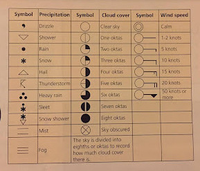
Cloud Cover: measured with your eyes (Oktas)
This is how we plot down weather Data:

Symbol meanings:
The water Cycle
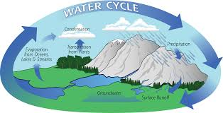
Evaporation: the process of Water turning into a gas (water vapour )
Condensation: the process of Water Vapour turning to a liquid
Precipitation: water falling from the sky, it could be a solid, liquid or gas form
Surface Runoff: The process of Water being moved by gravity towards larger water accumulations
Groundwater: Water stored in the ground/flowing in the ground
Transpiration: The process of a plant absorbing water and releasing water vapour through it’s leaves.
Cold air cannot hold water vapour
Hot air Can hold water vapour
╔══ ≪ °❈° ≫ ══╗
How do clouds form?
Firstly, the sun heats up the ground. This causes the air at ground level to rise and the air vapour within to cool down (since the further away from the ground the colder it gets)
When cooled, The water vapour collides and sticks to particles found in the air known as condensation Nuclei that contain aerosols such as salt and dust.
As the Water Vapour rises and cools, more Water Vapour accumulates and condenses on the surface of the Nuclei.
When enough water vapour condenses around the Nuclei a cloud droplet is formed.
Individual cloud droplets are lightweight, tiny and spread out so they stay afloat as the form of a cloud.
At times, the cloud droplets combine to become larger droplets or crystals. As this occurs, they grow in size and weight and gradually fall from the sky as rain.
╚══ ≪ °❈° ≫ ══╝
୨⎯𝕽𝖆𝖎𝖓𝖋𝖆𝖑𝖑⎯୧
There are 3 types of Rainfall in total
Relief Rainfall
Sun heats up land and Water evaporates from a body of water in close proximity of a mountain.
The water Vapour rises and begins to ascend the mountain, cooling the gas in the process.
The water condenses and falls on the singular side of the mountain.
On the other side, air descends warms and becomes drier. That is why the opposite side of the mountain is commonly drier, this is what we call the rain shadow.
Frontal Rainfall
Warm air rises
Air cools and condenses
Cloud formation
Precipitation occurs
Rain falls
Convectional rainfall
Sun heats up land then Water evaporates and rises as water vapour.
Water Vapour cools as it rises further upwards.
Cloud process/ Water vapour condenses
Rain falls
There are 10 types of clouds
Stratus
Flat or smooth
Cumulus/cumulo
heaped up/puffy, like cauliflower
Cirrus/cirro
high up/wispy
Alto
medium level
Nimbus/Nimbo
rain-bearing cloud
୨⎯How Climate Varies⎯୧
Biomes are global scale ecosystems like desert and polar.
They are completely dependent on the different climates in each location
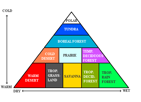
But what exactly makes the Climates so different from each other?
Well here are 5 factors that affect the Climate of a Biome.
Altitude
Contrary to popular belief, Getting closer to the sun will not make you any warmer. This is because the sun does not hit us directly but instead comes into contact with the ground and heats it up instead. From there, the ground warms up the air which supplies
us with warmth in the process.
The higher up we go, the further we are from the ground supplying us with warm and therefore it gets colder. This is also why we see snow at the top of mountains.
Rain shadow
Many deserts are found on the leeward sides of mountains while precipitation falls on the other side.
Distance to the Sea
In winter, the seas are warmer than the land and therefore warms up places closest to the sea. In summer, the sea is cooler so it instead decreases the temperature of the land.
Ocean Currents
The world's oceans move constantly in patterns that are called currents.
This can spread heat from the equator to places further north and south
Gulf stream
Warm water from the equator travels north from the Gulf of Mexico into the Atlantic Ocean. This part of the Gulf Stream is called the North Atlantic Drift.
୨⎯UK Extreme Weather⎯୧
Extreme weather is any weather event which is significantly different from the average or usual weather for a place at that time.
What reasons could the U.K experience Extreme Weather?
Reason 1: UK Roundabout
An air mass is a large body of air that travels from one place to another.
We use a combination of different words to describe these air masses
Maritime:
Wet Weather
Polar:
Cold Weather
Continental:
Dry Weather
Tropical:
Warm weather
Reason 2: Jet streams
A jet stream is a strong air current.
We are affected by the polar jet.
When the polar jet stream moves north over the UK, we get hot weather. When it moves south over the UK, we get cold weather.
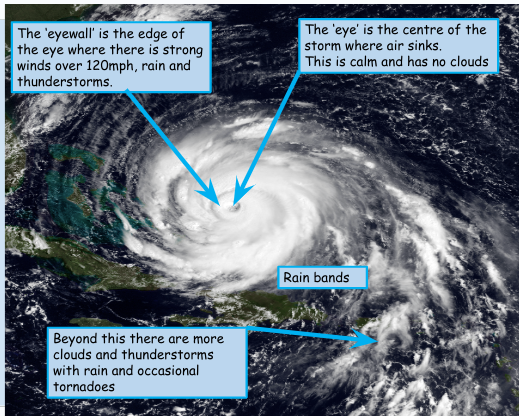
୨⎯What are Hurricanes?⎯୧
A tropical storm is a huge storm that develops in the Tropics.
Low pressure:
Areas where warm air rises upwards.
The Saffir-Simpson scale rates hurricanes on a scale of 1-5 according to their wind speed with 5 being the strongest.
Due to Storm Surges, being in close proximity to the coastline during a hurricane is incredibly dangerous and could end in copious amounts of death as well as this, hurricanes lead to large expenses and destruction of property due to flooding
Storm surge is the abnormal rise in seawater level during a storm, you see as pressure falls, water rises and as the hurricanes move, the strong winds push the water towards the land.
The three main hazards are…
Winds
Storm surges
Tornadoes
Case study: Hurricane Katrina
Hurricane Katrina was a major tropical storm which hit the city of New Orleans (among other places) in August 2005.
List of Impacts:
1800 deaths
300,000 homes destroyed
Shops were looted
Fuel prices rose
Tourism decreased, meaning loss of income for businesses.
3 million people with no electricity
Cotton and sugar crops destroyed
Damage to coastal habitats
80% of New Orleans was flooded
$300 billion of damage ($81 in New Orleans)
Coastal habitats were flooded
Structure of Tropical Storms;
Monsoons
What causes the Monsoon?
Worded explanation:
The monsoon is the wet season from june to october. It is caused when the winds change direction and blow moist air from the ocean over the continent. The himalayas are a physical barrier to these winds, forcing the air to rise and create relief rainfall. The winds change direction as the Land becomes warmer than the sea. In october, winds change direction again and the weather changes back to the dry season. In this process the land heats up quicker.
Moonsoon comes from the arabic word mausim meaning seasons and the term is normally associated with heavy rain
60% of the world’s population lives in areas affected by monsoons.
Accounts for 80% of the rainfall in India
70% of the indian population rely on the rain for agriculture
La Nina ensures wetter monsoons
Before a monsoon air pressure is high……..
Negatives of a Monsoon:
Marked Questions:
6 mark
Point
Evidence
Explain
x2
Conclusion: “I believe _____ is stronger“