
AP Human Geography Review
Ryo Kimura
AP Human Geography
Notes
3/19/2024
Unit 1
Reference Maps vs. Thematic maps
Reference Maps
Informational and display physical and man-made features
Thematic Maps
Tell a story by showing density and distribution of quantitative data
5 Key ways to map Geospatial Data
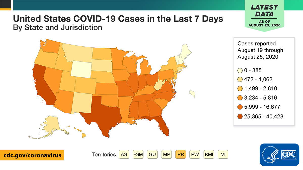
Choropleth maps - use colors or shadings
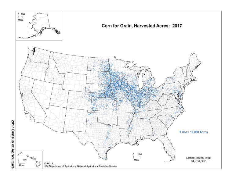
Dot maps - distribution maps
Graduated Symbol Maps - uses proportional symbol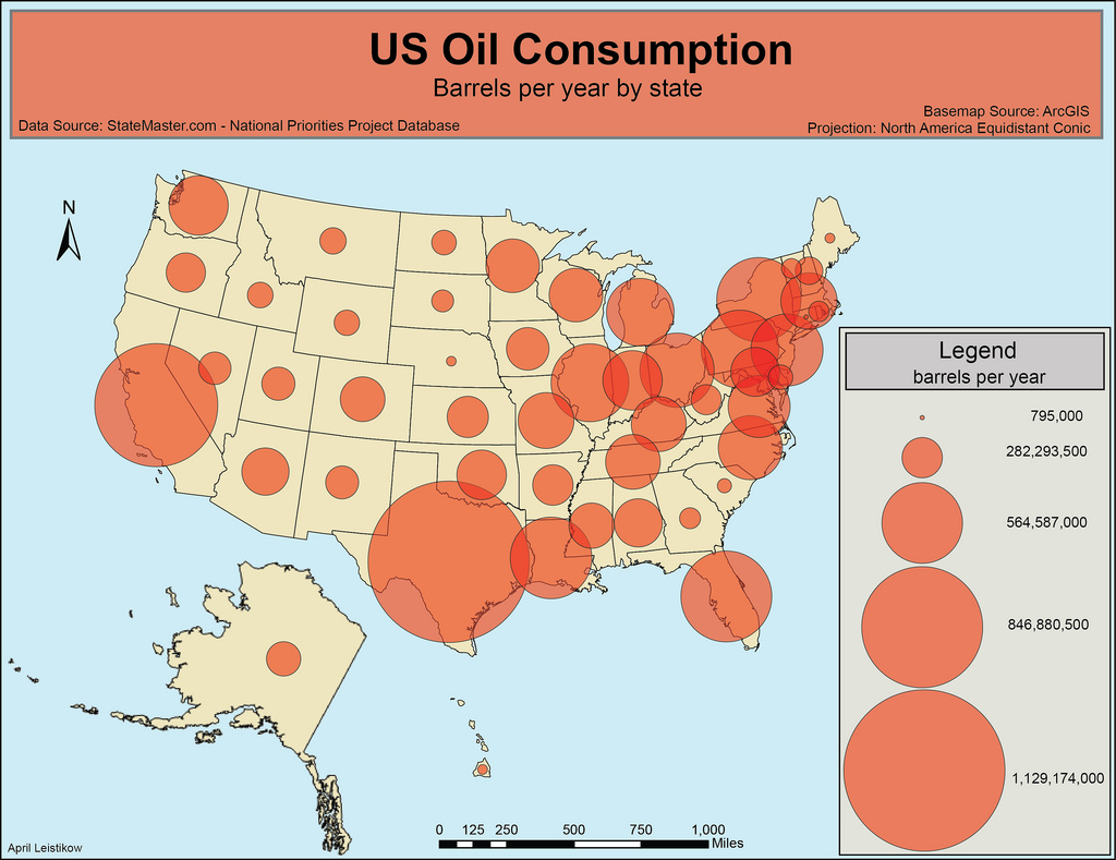
Isoline maps - shows equal value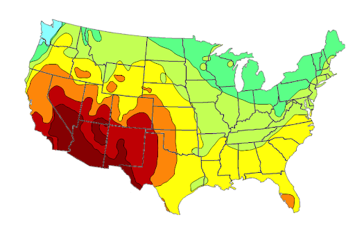
Cartograms - distort the appearance of places (Cartoony)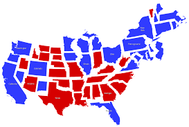
Absolute vs. Relative (Locations, Distance, and Direction)
Absolute (Quantitative measurement)
Relative (Qualitative Measurement)
Patterns and Processes
Clustered (grouped, nucleated, clumped, concentrated)
Dispersed (Distributed, scattered, spread out)
Uniform (evenly Spaced)
Random (no discernible pattern)
Map Projection
A map of Earth on a flat surface
Going to have distortion
Conformal projections preserve shapes of land features in exchange for distorting true size
Mercator Projection
Equal area: distort oceans to have accurate size of landmasses
Gall-peters Projection
Goodes Projection
Geographic Information Systems (GIS)
A computer system that collects stores, and analyzes
Remote sensing
Information gathered from satellites orbiting the Earth
Satellite Navigation Systems (GPS)
Provide very specific date about an location of an object using Latitude and Longitude
Online Mapping and Visualizations
A variety of sources provide online maps for people to analyze data including government, private companies,m and research institutions
Field observations
When someone visits a place and records info there
Media reports
Use reports from media outlets to help gather info about an area
Travel Narratives
Notes and stories about observations made in the field
Policy Documents
May look to legislation to gather geographic data
Personal interviews
Interview experts to gather info about specific place
Landscape Analysis
Process of studying and describing a place
Photographic interpretation
Use photographs to find observable data
Geospatial Data (Big Data)
Any data that is related to a specific point on Earth
Used by many sources to make decisions
Decisions
You (might use a GPS app to find the fastest route)
Company (might use data given by GIS to analyze sites for future projects)
Government (might use to make decisions about urban planning, transportation, and policy-making on funding)
Spatial concepts
When geographers refer to space they are talking about the physical gap between two places
Absolute Location
Concept of site / Describes a place in terms of Longitude and Latitude
Relative Location
Location in relation to other palaces
Helps understand significance of the place
Place
A unique and identifiable location with strong distinct characteristics
Flows
How different places may interact by having people or information travel between two places
How well different places interact with each other
Distance Decay
The Farther away a palace is from another, the less interaction they will have
Time-Space Compression
How interconnectedness and technology have reduced the time it takes for a person or idea to get from one place to another
Patterns
How are objects arranged in a place
Sustainability, Natural Resource and Land use
Sustainability
actions that provide immediate benefits while also preserving resources for future use
Natural Resources
Items produced in nature that can be used by Humans
Land Use
Changing the Earth’s surface for a specific purpose (Industrial, Agricultural, residential, transportation, recreational)
Human -Environmental interaction are often called cultural ecology
Culture is defined as “Way of life.”
Scale
Scales refer to the size or scope of a phenomenon
Scale of Analysis
Many different levels (local, regional, national, and global)
Scales can either hide or review different kinds of information.
Provides focus for research
Various scales interact with each other
Determines the level at which we analyze geographic data
Can inform, change and influence the decisions people make
Scale of Analysis in Quantitative and Geospatial Data
Ex: census data to analyze phenomena at different scales
Scales of Analysis in Images and Landscapes
Images have limits, such as Population density, you won't be able to know that with the picture alone
Scales of Analysis on Pattern
Analyze different phenomena at various scales to see if patterns remain the same or look different depending on which scale is used.
Variations in data
May tell a different story than data at another level
This can lead to people drawing contradictory conclusions based on the scale they were using
Different interpretations of Data
May reach different conclusions on what scale they are talking about.
Regions
Based on one or more distinct characteristics
3 types of regions
Formal - regions that have physical or human characteristics like language, ethnicity or faith
Ex: California Wine County: Counties that have hundreds of grape vineyards
Functional (Nodal) - regions that have a center of activity unified by transportation or communication networks
Ex: Airline Hubs such as Atlanta and Dallas
Perceptual (Vernacular) - regions are defined differently by each person accordingly, “Fuzzy” boundaries
Ex: “The South" has no boundaries or limitations
Regionalization
Chunking down large area into smaller areas using scales of Analysis to make observations to find patterns and processes
Unit 2
Population Densities
Arithmetic
Population / Total Land
Not reliable (includes non-arable land like deserts)
Physiological
Population or Arable Land (Land that can produce food)
Ex: 98% of Egyptians live on 3% of the land
Agricultural
Total Farmers / Arable Land
More Farmers = poor country
Country | Arithmetic | Physiological | Arithmetic | Percentage Farmers | Percent Arable Land |
|---|---|---|---|---|---|
Canada | 3 | 65 | 1 | 2 | 0.5 |
United States | 32 | 175 | 2 | 2 | 1.7 |
The Netherlands | 400 | 1748 | 23 | 3 | 0.01 |
Egypt | 80 | 2296 | 251 | 31 | 0.03 |
Ecumene
The permanently inhabitable land of Earth
75% of population live on 5% of land
90% live north of the equator
Planet Earth Ratio
¾ Water
¼ Land
⅛ = Inhabitable and Non-arable land: poles, deserts, swamps, high or rocky mountains
⅛ habitable land
3/32 = habitable, but not arable land, due to development
1/32 = Arable Land
Models
Demographic Transition Model
Bio
Developed in 929 by American geographer Warren Thompson
Premise
A graph that describes transitions in CBR and CDR from high to low in developed countries since the Industrial revolution
Assumptions
All countries’ populations will stabilize as they grow more wealthy
Definition
Visual Representations of something in the real world made in order to simplify a theory
5 stages of a demographic transition
Stage 1 | Stage 2 | Stage 3 | Stage 4 | Stage 5 | |
|---|---|---|---|---|---|
Birth Rate | High | High | Falling | Low | (Yet to be ) |
Death Rate | High | Falls more slowly | Falls more slowly | Low | Low |
Natural Increase | Stable or slow increase | Rapid Increase | Increase slows down | Falling and then stable | Little change |
Status | Hunting, Gathering, and Agriculture | Urban, Medical, Industrial, and Revolution | Urban, Medical, Industrial, and Revolution | Women’s Revolution | Women’s Revolution |
Spread of a disease
Epidemic
Local or regional outbreak
Pandemic
Global
The Epidemiologic transition model
Bio
Developed by Abel Omran (1971)
Premise
Focus on CDR
Transition from infectious to chronic disease
Assumptions
All countries transition because of the Medical Revolution
Geographical examples
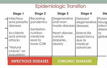
Rich countries’ CDR’s tend to be lower due to higher life expectancies
Economic Consequences of Aging Populations
Advanced industrialized societies are growing older, leading to a decline in the working-age population.
Social Consequences of Aging Population
It can affect economic growth and patterns of work and retirement
Political Consequences of Aging Population
More politicians with older ideals for the government
Disease in America
6 in 10 adults in the US have a chronic disease
4 in 10 have 2 or more
Ex: Heart disease, Cancer, Chronic Lung Disease, Strokes, Alzheimers, Diabetes and Chronic Kidney diseases
Some key lifestyle risks for these include tobacco use, poor nutrition, lack of physical activity, and excessive alcohol use.
ESPN of Ageing
Economic
Less workers = higher taxes
More money for senior services (Social Security and Medicare)
Less money for education
Social
More senior towns (ex., villages)
More jobs for seniors
More immigrants
Political
Older politicians have less focus on younger generations
A smaller pool for military
Women and Education
TFR (Total Fertility Rate)
Average number of kids a female will have
Childbearing years = 15 - 49
Ideal # = 2.1 Kids
High TFR = Stages 2 and # of the DTM (Less opportunities)
Low TFr = Stages 4 and 5 of the DTM (More opportunities)
Better able to care for their children
Creates job opportunities normally devoted to men
More schools = reduced population Growth
Women having education can lead to...
More money for the household
Increasing rate for the country's economy
More autonomy for women
One-Child Policy
Late Marriage (Urban)
Application for “Family Planning Certificate”
Any pregnancy or birth to a couple that does not possess a “family planning certificate” is considered a violation of regulations and will be charged a penalty.
One-child restriction
Second child restriction\
Salary Bonus
Land Bonus
Medical Benefits
Other Family Benefits
Mandatory birth control
Pregnancy exams
Sterilization
Abortion forbidden
Early Births
One child over quota
Two children overquote
Members of ethnic minorities
Disabled child
Lack of male in family line
Pronatalist and Antinatalist Policies and Ideals
Anti-natalism
The problem is overpopulation
The government restricts childbirths
More family planning
China, India, and poor countries
Encourages limiting the number of children
Pro-natalist
pronatalism problem is underpopulation
The government encourages more babies through incentives
Countries in Stage 4 and 5 (Japan, Italy, Russia, etc.)
Malthusian Theory
Developed by Thomas Malthus in 1798 (Start of Industrial Revolution in England),
Premise
Predicts overpopulation
Population increases geometrically, food production increases arithmetically.
Poor parents need to stop having more poor kids
Positive Checks
Increased CDR
War, disease, and famine
Preventive Checks
Decrease CBR
Marrying at a later age, abstaining from sex, birth control
Boserupian Theory
Developed by Danish economist Ester Boserup (1965)
Premise
Starvation motivates people to improve their farming methods and invent new technologies to produce more food.
Assumptions
More people = more brains = more solutions
Neo-Malthisians VS Cornucopians
Nep-Malthusians
Supporters of Malthus (Paul Ehrlich)
Over-population = loss of natural resources
Competition for limited resources = DOOM
Cornucopians
Supporters of Boserup (Julian Simon)
Food production kept pace with population growth.
NIR has decreased
Migration
Migration
The movement of people from a place of origin to another
Not to be confused with “immigration”
There are many types of migration
Causes can be ESPN
Topics
Causes of Migration
Forced of Migration
Forced and Voluntary Migration
Effects of Migration
Interregional (within a country)
US (Snowbelt to Sunbelt)
China (Rural to Urban)
International migration (Country to Country)
Stage 2 and 3 to stage 4 and 5 countries
Emigration
Moving away from a place
Immigration
Moving into a place
Net Migration
Differences between emigration and immigration
Factors
Economic Factors
Financial issues can hinder a migrant’s journey
Intervening Obstacles
The migrant runs out of money to complete the journey
Migrant face prohibitive costs to complete the journey
Intervening opportunity
Jobs available in a closer location
Economic situation improves at or near the place of origin
Ex: A rural Mexican farmer leaves his village because the farm he works on is now using machines instead of human labor to harvest crops, and he loses his job (push factor).
Social Factors
Social factors include issues related to religion, race, gender, sexual orientation, or ethnicity. It could also include factors like health or education
Push Factors
Religious persecution
Discrimination based on gender or ethnicity
Lack of school or education opportunities
Lack of available healthcare
Pull Factors
Freedom of religion
Acceptance of different ways of life in a new place
Better Educational opportunities
Political Factors
These factors include reasons for migration relating to the government or politics
Push Factors
Political persecution
Discrimination based on political views
Harsh government policies
Poor or cruel leadership
Political instability
Warfare or threat of warfare
Pull Factors
Political freedom
Safety to voice dissenting political views
Stable government
Fair laws
More trusted leadership or political system
Environmental factors
Environmental facts include any migration related to the natural world
Environmental factors include any migration related to the natural world. Historically speaking, those speaking there were the most common.
Push factors
Drought
Natural disasters
Human damage to the environment (i.e. Radioactive waste from a damaged power plant)
Pull factors
Farmable land is available
Safety from natural disasters (high ground, away from the coast, etc.)
Healthy, safe environment
Obstacles and Opportunities
Intervening Obstacle
Negative circumstances that hinder migration
Ex: Can’t afford to move
Intervening Opportunity
Positive circumstances that hinder migration
Ex: Jobs closer to home
Political Factors
These factors include obstacles or opportunities relation to the government or politics. THe most common obstacles migrants face today are political.
Refugees
Characteristics
No property or passports
Travel on foot or other means
Fear persecution, not poverty
IDPs vs. Asylum Seekers
Internally Displaced persons (IDPs)
Migrants were forced from their home due to political reasons but hasn’t crossed any borders
Asylum Seekers
Migrants from a foreign country seek safety and a better life.
Forced Migration
Migrants who have no choice but to leave
Examples
Slavery from Africa and the Trail of Tears (Native Americans)
The Rohingya (Myanmar); Syrians; VEnezuelans; Columbians, and Cubans
4 types of slavery
Debt bondage
Domestic servitude
Child labor (prostitution)
Child soldiers
Ravenstain’s “Laws”
Migration is related to demographics (1885)
Women are more likely to move internally but men move internationally
Young adults (singles) move more often than older adults (married)
Many move from rural (farms) to urban (cities)
Most move a short distance (financial and Family)
Temporary Status
The majority of migrants coming to the US each year are temporary
Student
Temporary professional workers
Tourists
Lawful permanent resident status
Around 1 million people become lawful permanent residents of the US each year
Represents less than ½ of one percent of the total US population
The main methods of permanent immigration
Over 60% of immigrants arrive on family-sponsored visas
Spouses, children, parents, or siblings of citizens;
Spouses or children of lawful permanent residents
The number of visas limited for each type of worker
Priority (CEOs of multinational companies, Olympic athletes)
Professionals with advanced degrees
Skilled workers
Investors ($1 million with creation of 10 new jobs for american workers)
Refugees and Asylum seekers
Refugee status requires proving one is personally at risk of persecution due to race, nationality, political opinion, religion, and membership to a particular social group
Special categories
Admissions each year are made through the diversity visa lottery or as part of a “vulnerable group.”
Vulnerable groups
US immigration laws offer special protections to some groups of people, like victims of domestic violence or abandoned children
Citizenship
Citizenship conferred on three groups of people
Those born in the US
Those born to US citizens abroad
Lawful permanent residents who naturalize, including their minor children
Nationalization requires that
An individual is a lawful permanent resident for 5 years.
Proficiency in english
Civics test, background and the oath of allegiance
Individuals pay a $725 application fee.
Migration Transition Model
Developed by WIlbur Zelinsky
Migration patterns change as a result of industrialization (Factory jobs)
Stage 2 and 3
High population and limited jobs lead to international migration (emigration)
Stage 4 and 5
A low and older population needs “guest workers” (temporary workers)
US Immigration
Xenophobia
Fear of foreigners
Nativism
Policy of protecting citizens and excluding immigrants
Ex: Immigrants take jobs from citizens
Chinese Exclusion Act 1882
bar Chinese immigration
Immigration Act of 1924
Favors West Europeans
Immigration and Nationality Act of 1965
Favorite families and skilled migrants
Undocumented Immigration
In 1014, the estimated number of undocumented immigrants in the US was 11 million, or 3.5% of the total population
People become undocumented immigrants in two ways
Enter the US without authorization
Overstay visa
Immigration Enforcement (ICE)
“If deported by immigration enforcement, individuals are barred from returning for at least ten years.”
Relocation Diffusion
Migrants bring their cultural traits
Language, religion, and ethnicity
Natives are reluctant to accept
Ex: ethnocentrism, racism, xenophobia
Acculturation
One culture dominates other
Ex: English replacing Native language
Assimilation
The loss of one’s culture
Ex: the “melting pot”
Transculturation
Equality of cultures
Ex: the “salad bowl”
Unit 3
Culture
The shared practices, technologies, attitudes and behaviors transmitted by a society
Culture Trait
A single attribute of culture, such as food, architecture, or land use
Cultural-isms
Ethnocentrism
Belief that one’s culture is superior to others
Ex: Other cultures’ food is "disgusting.”
Ex: Expecting others to speak your language
Cultural Relativism
Not judging a culture by one's standards
Ex: Accepting that others don’t worship like you (religion)
Accepting that others dont like the same music as you
Culture (Built) Landscape
Carl Sauer: "the forms superimposed on the physical landscape by man.”
Geographers analyze culture by “reading” the cultural landscape
Ethnic Neighborhoods
Definition
Concentration of people from the same cultural background located in certain pockets of major US cities
Mostly established through chain migration
Examples
Little Italy (NYC)
Chinatown (San Francisco)
Little Havana (Miami)
Sequent Occupance
When successive societies leave their cultural imprints on a place
Ex: St. Augustine (Timucua Indians, Spanish, American)
Ex: Mexico City’s Plaza of the three cultures
Non-material Culture
Things that are observable (education, religion, language, gender roles, art, music)
Migration and Culture
Questions
Define “American Culture” (Race, Ethnicity, Language, religion, music, and food)
Cultural Diffusion
The spread of culture from our hearts (the birthplace)
Relocation Diffusion
Migrants take their cultural traits with them
Ex: Holiday traditions
Migrants bring their cultural traits
Language, Religion, food, music, etc.
Natives sometimes are reluctant to accept (centrifugal forces)
Ex: ethnocentrism, racism, xenophobia
Acculturation
One culture dominates another
Ex: English replacing Native Native Languages
Assimilation
The loss of one’s culture
Ex: the “melting pot”
Transculturation
Equality of cultures
Ex: the “salad bowl”
Expansion DIffusion
Things spread from one place to another
Ex: Hip-Hop Music
Contagious (x: disease; fads)
Nearly all adjacent individuals are affected
Stimulus (Ex: McDonald's in india)
Ideas are adopted but altered
Hierarchical
Spread of an idea from top to bottom (powerful, rich, larger to smaller places)
Reverse hierarchical (Ex: Pop music and slang)
From teens to dictionaries
Pop Culture
Definition: Product of heterogeneous, industrialized cultures (American and European)
Example: Social media, movies, clothing, sports
Diffusion: Reverse (generational) and Hierarchical (big cities to small cities)
Music: $$$, catchy, hi-tech
Problems with pop culture
Cultural imperialism
belief that the US engages in cultural conquest
Instead of missiles, the US uses the Media
Globalization
Global values and traditions should be American-led
Ex: Democracy, English, Christianity, Capitalism
Cultural Convergence
Cultures and landscapes are merging
Loss of cultural diversity
Folk Culture
Definition: Traditional, homogeneous cultures
Examples: Amish, Cajuns, and Native Americans
Hearth: Anonymous and Rural
Diffusion: Relocation Diffusion
Music: Stories about life; transmitted orally; non-materialistic; acoustic instruments
Toponymy
Definition
Study of place names
Names reveal national origins, culture, language, routes of diffusion and history
Examples
Native American (Tuskawilla)
Religion (Western US has Catholic names)
Anti-colonialism (Africa - Swaziland and Eswatini)
Confucianism
Founder
Confucius (551 - 479 BCE)
Beliefs
Based on the chinese concept of Li (Correct Behavior),
Devised the 5 relationships
Diffusion
Mostly in China
Daoism (Taoism)
Founder
Laozi (604 - 531 BCE)
Beliefs
Based on a connection to nature
Dao = “The way”
Diffusion
Mostly in China
Hinduism Cultural Landscape
Temples and Crematoriums (Beliefs in reincarnation)
Varanasi (Spiritual city)
Ganges River (remission of sins)
Founder and Major beliefs
NA (est. 4000 years ago???)
Karma and Moksha (liberation)
Samsara (reincarnation)
Branches
Vaishnavism (80%) and Shaivism
Hearth
NW India (Indus River Valley)
Diffusion (Relocation Diffusion)
Aryans migrated into India and merged with Dravidians (est., the castle system)
Mostly in india (97%) and South Asia
Guyana, former British colony in South America (Indians migrated due to labor shortage),
Judaism
Ancient religion of the Jewish people.
Cultural Landscape
Synagogues
The Western Wall (aka, the “waling wall”)
Jerusalem
Sacred Sites
Geographic space linking heaver and Earth
Usually based on the lives of religious founders
Ex: Christianity (Church of the holy Sepulchrew, where Jesus was crucified)
Ex: Buddhism (Lumbini, Nepal, where Buddha was born)
Pilgrimage
A journey for religious purposes to a sacred site
Ex: Judaism (The western wall in Jerusalem)
Ex: Islan (the Hajj in Mecca, Saudi Arabia)
Founder and Major Beliefs
Abraham (about 2500 years ago)
Monotheism, the Covenant, the 10 commandments
Branches
Sephardim (MENA, expelled from Spain in 14920)
Ashkenazim (Eastern Europe)
Orthodox, Reform, Conservative
Culture Hearth
SW Asia (modern-day Israel)
Diffusion (Relocation Diffusion)
The Diaspora (Dispersal from the original homeland by the Romans in 70 AD)
Creation of Israel in 1948 (Zionism)
Dominant in Israel and the US
Universalizing Religion
Universalizing Religion
Attempt to be global and appeal to all people, wherever they may live in the world, not to those of one culture or location
Proselytizing
(Active seek converts)
Ex: Christianity, Islam, Buddhism, and Sikhism (North India)
Buddhism
Cultural Landscapes
The Bodhi (enlightenment) tree
Lumbini (Buddha’s Birthplace)
Stupas (Bell-shaped Burial mounds) and Pagodas (towers)
Founder and major beliefs
Siddhartha Guautama (Indian prince)
The 4 Noble truths, Nirvana, Maya
The truth of Suffering
The truth of the cause of suffering
The truth of the end of suffering
The truth of the path leading to the end of suffering
Branches
Mahayana (Largest in China, Japan, and Korea)
Therayana (Cambodia, Laos, Myanmar, Sri LAnka, Thailand, and more strict monks)
Earth and Diffusion
NE India (Nepal)
Relocation (missionaries and traders to East Asia)
Hierarchical (Conversion of Indian Emperor)
Syncretism (Buddha becomes a god in hinduism)
Christianity
Cultural Landscape
Church andCathedrals
Jerusalem
Space devoted to the dead
Founder and Major beliefs
Jesus and PAul of Tarsus
Monotheisum: Jesus is the Messiah
Cultural Hearth
Southwest Asia (East Mediterranean)
Relovation Diffusion
Converion of Paul (USed Rome’s road Syste to spread christianity)
European colonialism (Spain is catholic)
Hierarchical Diffusion
Roman Emperors (Contantinem Theodosius) proclaimed end to persecution and official religion
Russian Czar Vladimir Converts Russian to Orthodox
Branches of Christianity
Branches (Large, fundamental divisions within a religion)
Catholic (Latin America, Western Europe)
Protestant (North Europe, USA, Canada)
Orthodox (Russia, Eastern Europe)
Denominations
Subgroups within branches
Ex: Protestants (Lutheran, anglican, Presbyterian, Baptist, Methodist, etc.)
Islam: cultural Diffusion
Founder and Major Beliefs
Mohammad (7th Century)
The 5 pillars of Faith
Branches
Sunni (Saudi Arabia and Indonesia)
Shiites (Iran and Iraq)
Hearth and cultural Diffusion
SW Asian (Mecca, Saudi Arabia)
Relocation (INvasions of Palestine, North Africa , India, Turkey and Spain)
Expansion (Europe in stage 4)
Secularism and Syncretism
Theocracy
Government ruled by religious leaders
Ex: Iran is led by the Ayatollah (aka, The Supreme Leader)
Secularism
Separation of Church (Religion) and State (government)
Ex: France’s Laicite (Equal treatment of all regions)
Ex: USA (Public Schools)
Syncretism
Combining two different religions into something new
As religions diffused, they incorporated local customs
Ex: Buddhism (Buddha is the reincarnation of Vishnu in Hinduism)
Ex: Santeria in Cuba (Roman Catholicism + African Religions)
Unit 4
The State
Space w/ Recognized borders
Ex: Taiwan is not a state because China does not recognize
Ex: Palestine are not a state because the US does not recognize
Permanent Population
Ex: Vatican City’s population is less than 500
Organized Government
4 roles of government
Keep order, protect citizens, make laws, and help citizens
Sovereignty
Ex: England (UK), Catalonia (Spain), Puerto Rico (US), Greenland (Denmark), etc, are not states
Treaty of Westphalia (1648)
Thirty Year War
Religious Civil war between Catholics and Protestants
8 million casualties
Each prince could choose his kind’s religion
Two European Rulers (The emperor and the Pope)
Sovereignty (right to control your territory)
Est, boundaries and borders
Portugal and the Netherlands separated from Spain
Creation of States (the foundation of the modern world)
Territoriality
Geographic control over people, land, and resources
Connection of people, their culture, and their standard of living to their land
Creation of borders to control territory
Political Organization
City-states
Independent cities
Loyalty is too widespread, creating too much conflict
Empires (Imperialism)
Emperor conquers lands w/diversity of groups (different languages, religions, and ethnicities)
Loyalty to a far-away emperor was tough to maintain
Kingdoms (Feudalism)
People are subjects of a king or queen
The “State” (Nationalism)
People are citizens with rights
Loyalty is to one’s country
The “Nation”
Definition
Group of people united by ethnicity, language, religion, geography, and history
Have identified a homeland
Seek to control that homeland
Example
The UK is a state with four nations
England, Scotland, Wales, and North Ireland
The “Nationstate”
Territory whereby one nation has sovereignty over its space
Ex: Japan and Iceland
Self-determination
The right of a nation to control its own state, free from persecution
Ex: Catalonia (Spain) & Palestine (Israel)
Multi-nation State
Multiple nations occupy one state, which is hard to maintain
Ex: former Yugoslavia
Ex: former USSR
Irredentism
When two nations in different states wish to unite
Ex: Anschluss (NAzi Germany in Austria)
Ex: Crimea (Russians in Ukraine)
Multi-state nation
Definition
A nation’s homeland has a state of its own and also spreads into other states
Example
Koreans are one nation divided into North (Democratic People’s Republic of Korea) and South Korea (Republic of Korea)
Stateless Nation
Definition
A nation without sovereign territory
The nation is a minority group with limited rights
Examples
The Palestinians
The Kurds
Enclaves VS Exclaves
Enclave - a state within a state (Lesotho)
Exclave - a territory not connected to its state (Kaliningrad, Hawaii)
Autonomous (.semi-autonomous) regions
Definition
Area within a state having a degree of freedom from its parent state
Attempt to avoid conflict
Examples
China (5 regions)
USA (574 Native American reservations)
Native American Sovereignty
Public safety and justice
Education and culture
Communications and technology
Environment and energy
Infrastructure and Housing
Transportation and roads
Natural Resources, Land and agriculture
Human services and healthcare
Economic development and commerce
Centripetal and centrifugal forces
Centrifugal may lead to
Fails states (Syria); stateless nations (Kurds); ethnic nationalism (Basques); uneven wealth (Palestinians)
Centripetal may lead to
Ethnonationalism (India’s Hindus); equal wealth; respect for each other’s culture
Ethnic Cleansing or genocide
Persecution
Ethnic cleansing: The mass removal of an ethnic minority
Genocide is the mass extermination of an ethnic minority
The holocaust
6M jews killed in 1460 days
4110 killed per day
171 killed per hour
3 killed per minute
Rwanda (1992 - 1994)
800K - 1M Tutsi killed in 100 days
8000 - 10710 killed/day
334 - 447 killed/hour
6 - 7 killed/minute
When states fall apart
Alkalization
Breakup of states along national (ethnic) lines
Ex: Yugoslavia (Balkan Peninsula)
Devolution
When states fragment into autonomous regions
Ex: spain (catalonia); UK (Scotland)
Devolutionary Factors
Geography
Enclave (Hawaii), islands (greenland), mountains (the basques - pyrenees)
Ethnic separatism
One group wants more power
Ex: the Catalans (spain)
Ethnic cleansing or Genocide
Removal or killing of a group es: removal or killing of a group
Ex: Rwanda (the Tutsi); Myanmar (the Rohingya); China (the Uyghurs)
Nationalism
Extreme feelings and loyalty towards one’s nations
Minority nations feel excluded from their state and
Goal is to get a nation-state.
Supranationalism
Alliance of states to fin ESPN solutions
Economic (European Union and ASEAN
Social and political (Political UN, NATO, African Union)
Problem
States must give up some sovereignty
Ex: The UN does not represent all nations. It should be renames the US
Terrorism
Use of violence by non-state groups to force a state into grating demands
Examples
ISIS (Syria) and Boko Haram (Nigeria)
IRA (North Ireland) and ETA (Basque Spain)
How the US government categorizes terrorism
Foreign Terrorist Organizations (FTOs)
ISIS, Hamas, Houthi, and Taliban
State sponsors of terrorism
Iraq
Domestic threats
Supremacist in our own country
Colonialism
Definition
The purpose of territorial expansion for the benefit of the nation
Relocation of settlers to control new land
Exploit resources, natives, and land
Causes
The industrial revolution (raw materials)
Strategic military bases
Europe in stages 2-3 (overpopulation)
Examples
Spain (South America)
Britain (The sun never set on the British Empire.)
Europe (Africa and the Berlin conference)
Imperialism
Definition
The establishment of empires
Imposing authority over other nations
Imperialistic powers created multi-nation states, leading to violence within states
Examples
Europe (The scramble for Africa)
The BRitish Empire (Palestine and India)
King Leopold II of Belgium
Colonized of the Congo Free State (Democratic Republic of the congo)
Extracted rubber (for production of tires)
Through forced labor to make huge profits
Used torture, murder, kidnapping, and mutilation of people’s hands when rubber quotas were not met (about 10 mil people were killed)
Decolonization
Definition
80% of Earth was controlled by Europe (1492 - 1914)
The breakup of empires leading to the creation of nation-states esp. After WW2
European borders ed to multiple internal conflicts amongst nations
Examples
Vietnam (France)
Indonesia (Netherlands)
Korea (Japan)
India (Britain)
DRC (Belgium)
Diffusion of the Nation-State Model
DIffusion
Through relocation diffusion, European imperialists imposed their political ideas
Diffused the state model
Questions
Why do you think the greatest increase in colonies was between 1750 1800?
Why do you think the greatest decrease colonies happened between 1950 - 1975?
Land boundary Types
Geometric
Use longitude and latitude lines
Ex: Korea’s 38th Parallel (DMZ)
Superimposed
Est. by stronger states that ignore existing nations and their space
Ex: Africa (The berlin Conference)
Boundary Disputes
Definitional - over legal language
Locational - over interpretation
Operational - over functioning of boundaries
Allocational - natural resource distribution
Land boundaries
Definitions
A vertical plane cutting through rocks below and airspace above
Provide limits on sovereignty
How is a boundary created
Defined-legally negotiated
Delimited-line drawn on map by cartographers (Simply on a marp)
Demarcated-signs and walls on the ground (physically made as Fence or Walls)
Administered - how is the border governed
Border walls
Walls and other barriers built by countries to establish their borders and some of the oldest and most controversial elements in the cultural landscape
ESPN
Economic (cost of the wall)
Social and political (promotes nationalism, created tension between states)
Environmental (Impact on natural habitats, scars the cultural landscape)
Relic boundary
Relic
Boundaries that no longer exist but still holds significance
Ex: The Berlin wall and Great wall of china
Historical boundaries
Antecedent
Pre-existing boundary
Ex: african nations proper to Berlin conference
Subsequent
Boundaries established after nations have been established
Ex: Europe’s states aligned with its nations
Consequent
Est. to accommodate nations that cant get along
Ex: India and Pakistan
Sea Borders
UNCLOS (UN conference on the law of the sea)
States can claim up to 12 nautical miles
EEZ (Exclusive Economic Zone)]
Economica rights up to 200 nautical miles
Median Line Principles
Division of waters between 2 states located w/i 200 N miles
Chokepoints
Definitions
Strategic, narrow route that can be used for political gain
Oftentimes used as traderouts
Examples
Strait of Hormuz (links Persian Gulf and Arabian Sea)
Suez Canal (links the Red Sea and the Mediterranean Sea)
Strait of Gibraltar (links Mediterranean Sea and Atlantic Ocean)
Bosporus Strait (links Black Sea and Sea of Marmara by Turkey)
Strait of Malacca (links Indonesia with the South China Sea)
Shatterbelts
Definition
Areas where regional or global divisions collide and cause conflict at the local scale
Unstable areas located between conflicting regions
Mostly caused by political cultural divisions
Examples
Political (The cold war in Korea, Europe, and Vietnam)
Cultural / Religious (Kashmiri India vs. Pakistan)
Unitary states
Definitions
States with strong national governments
National government make all the laws
Laws apply equally everywhere
National government can abolish or create local units
Homologous and small states
Examples
China, Japan, France, and the United Kingdom
165 states around the world
Federal states
Definition
National and local governments share power
Nation governments don't have total power
National government cant create or abolish local units
Usually in multi-national heterogeneous states
Examples
Canada, Australia, Mexico, Germany
USA (Federal Government cannot control education while state government cannot control immigration)
Four roles of government
Keep order
Protect the country
Help Citizens
Makes Laws
Democracy
Definition
A system of selecting policymakers and of organizing government so that policy represents and responds to the public’s preferences
Components of traditional Democratic theory
Equality in voting
Effective participation
Enlightened understanding
Citizen control of the agenda
Inclusion
Political culture
Adherence to political ideas
America = individual freedom
Asia = group identity
Human territoriality
A country’s attachment to its territory
Redistricting
Apportionment
Determines number of US House reps every 10 years
Voting districts
Areas where residents elect reps to congress
Determined by US Census
Redistricting
Process of redrawing internal political boundaries
Determine voting districts
Should be geographically compact
Ex: FL gained one seat (Gained 2.7M peeps for a total of 21.5M)
Gerrymandering
Drawing political boundaries to give your party power
Cracking
Spreading opportunities as across many districts as a minority
Packing
Concentrating opposition in one
Geopolitics
Pre-WW1
Multipolar system (Britain, France, and Russia competed for power)
Post WW2
Bipolar system (US vs. USSR engaged in a “Cold War”)
Post Cold War
Unipolar system (US only superpower)
21st Century = ?
Multipolar (US, Russia, China, India, Europe)
Bi-polar (US vs China)
Nont of the Above
Territorial Morphology
Size, Shape, relative location determine whether or not a country survives
Size
Large does not equal success, or vice versa
Shape
Ideally, goal to control territory
Relative location
Better off in the West
Better off if country is at crossroads
Compact
the most idea because governments can control easily
Roughly circular, oval or rectangular
Distance from geo. center not great
Easier to control
Ex: Cambodia
Elongated
the most problematic because revolts occur far from the capital
Long and narrow
Ex: Chile
Prorupted State
Narrow, elongated extension leading away from the main body
Ex: Thailand
Perforated State
Territory completely surrounds that of another state
Ex: South Africa and Lesotho
Unit 5
Bad Ingredients
Red 40
Synthetic food dye made from petroleum
Linked to aggression and mental disorders like ADHD in children
Used in candy, sports, drinks, makeup, etc
Corn syrup
Synthetic sweeteners used in sodas, candy, etc.
May be linked to obesity, diabetes, and heart disease
Intensive Agriculture
Intensive farming
Lots of workers
Small plots of land, usually near cities
Market gardening (truck farming)
Spoil quickly
Fruits and veggies
Plantation Agriculture
Cheap labor
Coffee, Cacao, and sugar
Mixed crops and livestock
Crops to fatten animals corn and soybeans
Extensive farming
Extensive farming
Less labor
Large plots of land away from cities
Shifting cultivation (slash and burn)
Farmers cut and burn rainforest
Plant many crops
Heavy rain clears the soil, so they move
Nomadic herding
Moving with the animals (goats sheep, etc)
Transhumance
Ranching
Animal Domestication
Domestication
Quality trained into an entire population through generations of living with humans
Primary uses
Meat; Milk; Fertilizer; “Machines” (ie, plowing)
Secondary Uses:
Clothes; tools (bones); Jewelry; Religion
Out of 148 large mammal species on Earth, no more than 15 have ever been domesticated.
Jared Diamond
“Our failure to domesticate even a single major new plant or animal in modern times suggests that ancient peoples really may have domesticated all the ones worth domesticating.”
Vertical Integration
Farm hierarchy (companies at the top and farmers at the bottoms)
Production, storage, processing, distribution, marketing, and retailing
Farming is no longer a primary activity.
Economic activities
primary/ extractive (agriculture)
Framing, mining, fishing, and forestry
Secondary (Manufacturing)
Factories
Tertiary
Retail, restaurants, etc.
Quaternary (Offices)
Gov’t, banking, IT, etc
Quinary (Post-Industrial)
Medical research, higher education, etc.
From Farming to Manufacturing
“A nation’s diet can be more revealing than its art or literature.” - Eric Sclosser (Fast Food Nation)
Regional diffusion
Relocation and contagious diffusion took agriculture to nearby regions
Ex: Anatolian of Indo-European language
Globalization of Agriculture
States are economically interdependent
Colonialism forced countries to grow luxury crops (Ex: coffee)
Poor states lack resources to develop (Ex: ports, roads, energy, etc.)
Rural patterns
Clustered (nucleated)
Housing is grouped closely
Ex: Europe
Dispersed
Housed spaced far apart
Ex: USA
Linear
Housing follows a river or a road.
Rural survey systems
metes and bounds
English system using landmarks
Long lot
French system
Farms extended from rivers (were long and thin)
Ex: Louisiana and Quebec, Canada
Township
US system using latitude and longitude
Farms organized into rectangles
Township and range
Each township is six miles square and contains 23,040 acres, or 36 square miles
Each township is divided into 36 squares. These sections are intended to be one-mile square and contain 640 acres of land
Sections are numbered consecutively from 1 to 36, starting in the NE corner
Bid-rent theory
Supply and demand
Cheap land = high supply
Expensive = low supply
Geo Distance
Cheap land is available far from the market
Land is most expensive and closest to the market
Assumption of land
and is isotropic (flat)
city is self-sufficient
Same soil and climate everywhere
Farmers transport their own goods
Farmers want money
The isolated state
Bio
J.H. Thunen (Germany 1826)
Premise
What to farm? (perishability of food)
Where to farm? (intensive vs extensive)
Transportation costs? (most important)
Models
Morphology (4 concentric circles)
Central city
Market Gardening
Forest
Increasing extensive field crops, grains
Ranching, livestock
Closer to the city (highly perishable) = expensive land offset by cheap transportation
Far from the city (Less perishable) = cheap land offset by expensive transportation
Examples and limitations
Geographic example
Sequence of US agriculture
Assumptions
All land is flat; Soil and climate are the same; farmers transport own products and want to make money
Limitations
Improves transportation (Ships and trains)
Multiple Markets (cheaper labor) and climates
Technology (refrigerators, preservatives, etc.)
Third Revolution (20th Century)
Vertical integration
Farming is no longer a primary activity
Commodity chains
Links producers, companies and consumers
Intensive mechanization
Rich regions can afford machines
Increased use of pesticides and fertilizers
Rise of Agribusiness and Factory farming
Large corporation are replacing family farms
Increased economies of scale = cheap food
Biotechnology
Increase in the use of GMOs
The green revolution
Bio
Norman Borlaug (1970 Nobel Peace Prize)
Premise
End global hunger
Diffusion of old technology to poor states
High yields seeds (IR36 rice), use of chemicals, and machinery
Successful
Reduced starvation
Mexico and India exported food
Unsuccessful
Africa (high prices and environmental degradation)
Machines displaced women
Genetically modified organisms
Foods where the DNA has been modified in a lab
US does not label GMOs
Examples
Bell peppers with fish DNA to make it drought-tolerant
Potatoes that release their own pesticide
Genetically modified mosquitoes to eliminate disease
Injecting jellyfish DNA into rabbits to glow in the dark
Global hunger
World hunger is the result of…
Distribution systems
Costs
Gender bias
Food Dessert
Areas where access to affordable, healthy food (especially fresh fruits and veggies) is limited due to finances and travel distance
Unit 6
Site and Situation
Influences origins and growth of cities
Sites
Physical location
Climate, water, soil, quality, etc.
Situation
Relative location
How does it connect to other cities
Origin Concepts (Orlando)
Toponymy
Study of place names
Geography
ORlando is built around a fort
History
Seminole- Indian Wars
Transportation
Two days from Sanford to Orlando
City
General Definitions
Rural = Farms and Villages with low density of people
Urban = Areas with high density of people and now built vertically (aka, skyscrapers)
Suburbs residential areas far from the city center (formerly farms and built horizontally)
Specific Definitions
Metropolitan Area = A collection of adjacent cities where population density is high and continuous (Ex: City of Orlando)
Metropolitan Statistical Area = A city of at least 50,000, its county and adjacent countries that have a connection (Ex: Orlando - Sanford-Kissimmee)
Micropolitan Statistical Area = city of more than 100,000, its county and adjacent counties
Mega, Meta, and World Cities
Megacities
10 million or more
LA, NYC, MXC
Increasingly located in the poorest countries
Metacities
20 million or more
Lagos (Nigeria); Bombay (India); Tokyo (Japan)
World Cities
Economic centers
Ex: NYC, London, Tokyo
The Suburbs
Migration of upper/ middle class residents from the city to the outskirts (former farmland)
Created by cars, highways, and cheap farmland post World War II
Cultural reasons
Less pollution, crime , and congestion
Desire for a “nuclear family,” large homes, and better schools
“White flight” (movement of richer folks from inner city to outskirts)
Urban Sprawl
Unrestricted, reckless, rapid, expansion of housing, commercial development and roads
McMansions (“supersized” homes)
Exurbs (prosperous residential districts beyond the suburbs)
Boomburbs (rapidly growing suburban cities)
Edge cities (suburbs along major highways)
Urban Sustainability
Transportation
Cars expended the city and changed its morphology (shape)
Population growth
Created need for more services
Migration
Created hoods based on social and racial groups
Economics
Cities are economic centers
Ex: Orlando (theme parks), Detroit (cars), San Francisco (Hi-tech)
Government
Must meet citizen’s needs
Key elements of Urbanization
Population (US says at least 2500)
Economy (Basic and non-basic sectors)
Political Organizations (boundaries and governments to regulate taxes and services)
Urban culture (a city’s “personality”)
Urban Landscape (the style of a city: unique architecture and landmarks)
John Botchert
The US city morphed from small, compact shape to a big start due to change in transportation modes
Stage 1: Sail - Wagon (1790 - 1830)
Stage 2: Steamboats and Iron Horse (1830 - 1870)
Stage 3: Steel - Rail (1870 - 1920)
Stage 4: Auto - Air (1920 - 1970)
Intra Urban Growth Model
The Car that birthed US cities
Origins
First invented in Germany and France in the late 1800s by Gottlieb Daimler and Karl Benz
Henry Ford innovated mass-production techniques (economies of scale)
Ford, General Motors and Chrysler emerged as the “Bog Three” auto companies by the 1920’s
Effects
Spurred the growth of tourism-related industries, such as service stations, roadside restaurants and motels
The construction of streets and highways, peaked when the INterstate Highway ACT of 1956 inaugurated the largest public works program in history
Eminent Domain - the government's right to take private property for public use
Changed the architecture of the American house, altered the conception of the urban neighborhood, and freed homemakers from the confines of the home
Urbanization: the good
Fewer people live in rural areas (better for forests, soil, and wildlife)
Lower family sizes
Better education
Better health
Urbanization: the bad
Hazards of site - being more susceptible to landslides, floods, etc.
Loss of Land - valuable farmland is lost
Natural landscapes become “urban jungles.”
Impact of Pollution - growing volumes of contaminants
Production of waste - lack of sewer facilities; increase of landfills
Large demand for water
Changing consumption habits - urbanites waste more
Urbanization Sustainability
Traditional zoning (Problem)
regulates land use (commercial, residential, industrial)
Mixed Land Use (Solution)
Permits different use in the same building
Urban Infilling
Encourages development of understandable or vacant land to increase density
Places new development near resources and infrastructure
Ex: The Railyards, Sacramento, California
New Urbanism
Sustainable urban planning focuses on early 19th century towns
Criticisms
Lacks of privacy as homes are too close to each other
Cars are still required
Conformist, inauthentic landscape
Racial and social segregation still exist because prices are still high
Principles
Walkable blocks and streets
Public spaces
Everything within walking distance (anti-car community)
Egalitarian (community affordable for everyone)
Urban Heat Island
It occurs when cities replace natural land cover with pavement, concrete, and buildings that absorb and retain heat
Increases energy cost (Ex: AC), air pollution levels and heat related illnesses
Brownfields
Sites that have been abandoned and have environmental contamination
There may have been gas stations, landfills, dry cleaners, railroads, etc
First Urban Revolution
5 hearths = Mesoamerica; Mesopotamia (Tigris and Euphrates); Egypt (Niles); India (Indus): China (Huang He)
Agricultural villages were egalitarian; the sharing of food introduced stratification (social class)
A ruling class (urban elite) ruled
City life = food surplus + stratified societies
Examples
India
Rome
Second Urban Revolution
Movement of people to cities to work in manufacturing
Made possible by
2nd agricultural Revolution (improved food production and surpluses)
Industrial revolution (cities near resources)
Gideon Sjoberg
Cities are products of their societies
Folk-preliterate (defensive walls)
Feudal (small town)
Pre-industrial (focus on religion and trade)
Urban- industrial (rise of skyscrapers)
Changes that drive Urbanizations
Transportation
US cities evolved from small to gigantic due to evolution of transportation
Communication
The internet could make offices and shopping malls obsolete
Population growth and migration
Moving from farms to factories to cities to suburbs
Economic Development
A City’s economy will impact manufacturing, tourism, and services
Government policies
State and local governments try to make cities attractive
Good schools, safe neighborhoods, lots of entertainment, high paying jobs, etc.
Urban Planning and design
Began in 19th century but accelerated in 20th century
Impact was the zoning law of the 1920s. This law establishes patterns of land use
Functions of cities
Basic Sector: people who engage in exports (city’s income)
Non-basic sector: others are engaged in services
Economic base = ratio of basic to non-basic (always larger because of the need to support the basic sector)
The gravity model
Based on Newton, which predicts gravitational force between two objects
Interactions between urban centers can be calculated by size and distance
Large cities have greater drawing power
Cities and population
Rank-size Rule
Smaller cities are a proportion of the largest city
1st city = 12M; 2nd city = 6 M; 3rd city = 4M, etc
Primate City (Mark Jefferson)
Twice as large and twice as popular as the next city
Ex: Paris, Longsdon; Mexico City;
US does not have one, but do not ignore scale
Ex: LA, CA - 16M, SF, CA - 7M population
Central Place theory
Bio and morphology
Walter Christaller (Germany 1933)
Morphology (Hexagons)
Premise
Threshold - minimum pop needed to support a service (low order - small population; high order - large population)
Range - maximum distance you’re willing to travel for a good (low order - short distance; high order - large distance)
Larger cities are spaced farther from each other; smaller places are closer to each other
Christaller’s Assumptios (Central Place Theory)
Surface is flat (no barriers) w/ equal transportation
Evenly distributed population with equal income
Each service has a max distance for sale in all directions
Consumers shop at the closest place possible
Hexagonal Model
Centrality = maximw aize access form hinterlands
Each center has a monopoly on goods and services (Price and distance are crucial)
Urban realms models
Inclusion of other “downtowns”
Bid-rent Theory
Different activities bid different amounts to be close to the CBD
Ex: Banks bid higher for CBD location than factories and families
Ex: banks can build up but factories build out
Reasons why the US City is a vertical city
Services and the urban hierarchy
“Low-order” services
Services obtained regularly, such as at a grocery store
Hamlets, villages, and towns
“High-order” services
Services required less frequently, such as a pro sports team
Cities (megacities, megacities)
The more services, the lower the order
Concentric zone model
Developed by EW Burgess (Chicago on 1925),
Relies on the thunen model (bid-rent theory)
CBD is the nucleus of the US City
Morphology (5 concentric rings)
US are arranged by wealth
Poor live closer to the CBD (housing is more dense)
Rich live further from the CBD (The commuters Zone, ie. the suburbs)
Assumptions
Surface is lat
Transportation costs are equal, CBD is the most important
Individuals maximize profit . minimize costs
Sector model
Developed by Homer Hoyt (Chicago 1939)
CBD’s s the number of nucleus of the US City
US citites are arranged by transport corridors
Poor live closer to transportation
Mutiple Nuceli Model
developed by Chauncy Harris and Edwarf Ullman (1945),
CBD is no longer the nucleus of the US city
US cities are arranged by suburban CBD’s
Poor people live closer to the bad stuff
Rich areas are so far from the CBD but closer to Suburban CBD
Galactic city (Peripheral) Model
Developed by Chauncey Harry (Detrioit 1960s)
Edge citizens are now the focus
Services and business (ex., shopping mails) move away from the CBD
US cities are arranged by highway and beltways
The car has conquered public transportation
Classic models of urban structure
Concentric Zone: wealth
Sector: Transportation
Multiple Nuclei: CBD, not the nucleus
Galactic (Peripheral) edge cities
Squatter Settlements
Dense areas built illegally in developing countries
Ex: Brazil’s favelas
Lack of amenities (schools, water, sanitation, etc.)
Located on outskirts of cities
Latin-American Model
Bio and Morphology
Larry Ford and Ernest griffin (1980)
Morphology (Concentric and Secot Models)
Premise
Law of the Indies required central plaza
The ”Spine” is the heart of LA and is surrounded by best stuff
Zone of IN Situ Accretion (constantly being built)
Opposite of US City (rich live closer to CBD, poor further away)
Geographic Example
Most LA cities
Law of the Indies
Laws that planned Spanish colonial cities
Must include
Plaza
Church
Government buildings
Ex: Mexico City, Caracas, Lima
African Model
Bio
Harm de Biji
Premise
3 CBD’s
Colonial CBD (Skyscrapers and grids)
Traditional CBD (Single story buildings)
Market Zone
Slums are far from center
Limitations
Outdated (excludes middle class and wealth areas)
Southeast Asian Model
Bio and Morphology
TG McGee (1967)
Combo of concentric and Secot models
Premise
No Frmal CBD
Old colonial port zone is city focus
Suburbs and squatters combined
Agriculture (prrimary) and Industry (Secondary) are on outskirts
Limitations
Adopted US Style CBDS
European Cities
Greenbelts
Countryside surroundings a city
Prevent urban sprawl (no competition bet. Brubs and CBDs)
Microdistricts
Impacts of government planners in communist states (goal is self-sufficiency)
Central square, no CBD, no Suburbs
Urban Greenbelts
An area of open land around a city on which building is restricted
Ex: UK (14 greenbelt areas)
Criticisms
No building = higher prices for homes
Increases # of commuter towers built outside the Greenbelt
Urban Sustainability
Traditional Zoning (Problem)
Regulates land use (commercial, residentialm industrial)
Solutions
Mixed Land Use
Greenbelts
Infilling
New Urbanism
Criticism
Expensive homes; confomist landscape; racial and soscial segregation;
Racial Segregation
Environmental injustice
Minorities more likely to live in worst part of city (railroads, power plants, etc.)
Growth of “disamenity zone” (no access to amenities like police and fire)
Rise in food deserts
Redlining
Banks refused to loan to “risky” neighborhoods
Blockbusting
Real estate agents persuade whites to sell ther homes for cheap
Black folks then move in at higher prices
Two types of segregation
Segragation du jour
This is by law such as the segregation laws of the southern states from 1870s until 1950s and 1960s
De facto Segregation
Not by law by by policies of banks like “redlining” or “blockcbusting”
Another more recent example groups falling into more affluence or more poverty
Some Final Terms and Concepts
Inclusionary Zoning LAws
Create affordable incentives for developers to set a minimum percentage for low-ncome housing
Orlando has an affordable housing crisis for even the lower-middle class
Land Tenure
Issue that squatter settlements face
They do not have legal rights associated with land ownership
Eminent Domain
The government’s right to take privately owned property for public use / interest
Ideally, it allows the government to build something to improve the lives of all the citizens of a community
In reality, it has been used in urban area to eliminate low-income neighborhoods
Unit 7
The Industrial Revolution
Hearth = UK (1750)
It began as result of new tech and the use of raw materials (coal, Iron, and sheep)
Migration from farms to cities due to factory jobs
Caused food supplies and populations to increase
The IR and Population
Food supplies increased
Along with 2nd Agricultureal Revolution
Proved Malthus wrong
Populations increased
Alon with medical revolution
Demographic transition Model (as countries develop, populations stabilize)
The IR and politics
Led to the rise of social classes
Led to the rise of economic systems
Led to the rise of worker’s union
The IR, Colonialism, and Imperialism
As europe industrialized, they recognized the values of possessing colonies
Colonies provided
Raw materials like sugar, cotton, minerals, etc. for use in factories
Labor to extract raw materials
Markets where manufacturers could sell the products
Ports where trading ships could stop and refuel
Profits to use for investing in new factoorues and railroads
Results of the industrial revolutions
Economic changes
Expansion of world trade
Factory system
Mass production of goods
Industrial capitalism
Increased standard of living
Unemployment
Political changes
Decline of land aristocracy
Growth and exxpansiin of democracy
Increased government involvement in society
Increased power of industrialized nations
Nationalism and imperialism stimulated
Rise to power of business people
Social changes
Development and growth of cities
Improved status and earning power of women
Increase in leisure time
Population increases
Problems - economic insecurity, increased deadliness of war, urban slums, etc,
Science and research stimulated
Deindustrialization
Deindustrialization
Decline on manufacturing (secondary jobs) in developed countries (1960s)
Forces US to focus more on services (tertiary sector) and education
NDDL (New international Division of Labor)
Shift of production from developed to developing countries
Cheaper labor in developing countries (Mexico and China) created the Rust Belt
NIDL (New International Divison of Labor)
Shift of production from developed to developing
Ex: The Rust Belt (Jobs to MX and China)
Maquiladoras
US companies in Mexico
Outsourcing
Companies cut costs by finding the cheapest labor
New Manufacturing Zones
Special economic zones
Trade laws are different from the rest of the country
Promotes foreign investment
Export processing zone
Areas in poor countries that assemble foreign goods
Maquiladoras (US companies along Mexico’s border)
Free trade zone
Area around a port or airport that is tariff free
Special Economic Zones
Area in a country that is subject to unique economic regulations that differ from the other regions of the same country
Companies receive tax incentives and the opportunity to pay lower tariffs
Fordism (Economies of Scale)
System of mass production based on division of labor
Workers hated it because work was repetitive
Consumers hated it because products were all the same
Mass Production = cheap prices
Levitown
Homes were built on an “assembly line.” pieces would be delivered to the site and over two dozen construction teams would be delivered
Post-Fordism
Automation
Robots replace the human assembly line
Just-in-time delivery
Japapnese system whereby companies only produce as goods are orders
Reduces inventory sitting around in warehouses
Outsourcing
Companies cut costs by seeking cheaperlabor elsewhere
Ex: India (Tech support call centers)
Ex: China (iPhones)
Ex: Mexico (Cars)
The Four Industrial Revolutions
1st = mechanization, steam power, weaving loom
2nd = Mass production, assembly line, electrical energy
3rd = automation computers and electronics
4th = cyberphysical systems, internet of things, networks
Economic Sectors
Primary (farms)
Farming, mining, fishing, forestry
Secondary (Factories)
Manufactoring, building
Tertiary (Service / offices)
Marketing, banking, retail, hospitality, etc.
Quaternary (Kniwkefge - based)
Includes research and development, business consulting, financial services, education, public administration, and software development
Quinary (highest levels of decision making)
Government (the President), business (CEO)
Human Development Index
Measures quality of life
3 factors
Life expectancy + education + GNI = 1.0
Closer to 1.0, the better the country
Sustainable Development Goals
Measure progress in ________.
Natural resource depletion
Mass consumption
Pollution
Climate change
Equality
Ecotourism (environmental friendly)
Material index
Total weight of raw materials / total weight of finished product
final product weighs < raw materials, location is the source
Ex: paper, pencils (weigh less than trees)
final product is bulkier or weighs > than raw materials, location is at / near market (weight - gaining industry)
Ex: beer, soda (adding water), cars
Gender Inequality Index
3 factors
Reproductive Health
Women who die giving birth + teens who give birth
Empowerment% in government and education
Labor Market
Pay, management, and % working
Global Trade
Comparative Advantage- ability of one competitor to produce a good or service at a cheaper price
Neoliberalism- trade policies to increase global trade with lower taxes and tariffs
Microloans and microfinance
Small loans so women can create small businesses
Usually provided by individuals or NGO (Non-government organization) rather than by banks or governments
Women are prothing to be credit worthy, which creates more loans for more women
Improves standard of living
goal is to achieve independence
Global Trade
Comparative advantage
Ability of one competitor to product a good or service at a cheaper price
Complementarity
Trade = one area having what another area wants
Newliberalism
Trade policies to increase global trade with lower taxes and tariffs
Free markets over governments
Ex: EU (European Union); OPEC (Organization of Petroleum Exporting countries);
Modernization Model
Bio
WW Rostow (1960)
Economic Adviser during Vietnam War
Staunch capitalism
Premise
All countries can develop and rise out of poverty by adopting capitalism
If Europe and the USA can, then so can the rest of the world
Geo Examples
UK was the 1st country
Singapore (1965 - today)
Rostow Model
Stage 1: Traditional Society
In Agriculture
Stage 2: Transitional Stage
Investment in infrastructure
Stage 3: Take off
Industrialization and urbanization
Stage 4: Drive to Maturity
Tech innovation and heavy industry
Stage 5: High mass income
High incomes and service-oriented economy
Core - Periphery Model (World Systems Theory)
Bio
Immanuel Wallerstein (1970s)
Premise
Countries are interdependent
Core (developed) = rich countries (highly skilled; mass consumption; tertiary sector)
Periphery (Underdeveloped) = poor countries (low skills; raw materials; primary sector)
Semi-perriphery (developing) middle class (secondary sector)
Geographic examples
Core (USA, Canada, Europe, Japan, Australia)
Periphery (Sub-Sahara Africa, Central America)
Semi=periphery (BRICS - Brazil, Russia, India, China, South Africa)
Dependency Theory (Neocolonialism)
The idea that resources flow for poor, developing countries to rich, developing countries
Developing countries have natural resources (like oil) and cheap labor
Developed countries buy raw materials and use cheap labor to make products
developed countries need these jobs and remain in a constant state of “developing” while developed countries get rich
Dependency Theory
Periphery kept in a cycle of debt to the core
Commodity Dependence
When a country relies too much on one product
Price drops or natural disasters can be severe
Liberalism
Assume all countries will develop
Structuralism
The world economy is rigged to favor the rich
Evaluating the model
Geographic connections
Core (Developed)
Periphery (Developing)
Semi-Periphery (BRICS - Brazil, Russia, India, China, and South Africa)
Limitations
Anti-capitalist
Neglects culture (not all want to be “rich”)
Can be used at any scale (USA - core is NE, Periphery is Appalachia)
Conditions in the periphery
Politics (unstable; corrupt leaders; misuse of foreign aid)
Demographic (high rates of birth; death; infant mortality; malnutrition and disease; rural populations; overcrowding in urban areas)
Social (gender inequality; low literacy rates; small middle class)
New International Divison of labor
Periphery dependent on Core for jobs, core dependent on PIngs for cheap labor.
multinational corporations need to reduce costs (get tax cutsm cheap labor, no pollution fines)
Management tends to be in wealthy countried; Manufactoring in poor countries (ex: nike)
Locations Models
Weber’s Model
Manufacturing plants will locate where costs are the least (least cost theory)
Costs: Transportation, labor, and agglomeration
Hotelling’s model
location of an industry cannot be understood without reference to the other industries of the same kind
Losch’s model
Manufacturing plants choose locations where they can maximize profit
Benefit: Zone of Profitability
Ryo Kimura
AP Human Geography
Notes
3/19/2024
Unit 1
Reference Maps vs. Thematic maps
Reference Maps
Informational and display physical and man-made features
Thematic Maps
Tell a story by showing density and distribution of quantitative data
5 Key ways to map Geospatial Data
Choropleth maps - use colors or shadings
Dot maps - distribution maps
Graduated Symbol Maps - uses proportional symbol
Isoline maps - shows equal value
Cartograms - distort the appearance of places (Cartoony)
Absolute vs. Relative (Locations, Distance, and Direction)
Absolute (Quantitative measurement)
Relative (Qualitative Measurement)
Patterns and Processes
Clustered (grouped, nucleated, clumped, concentrated)
Dispersed (Distributed, scattered, spread out)
Uniform (evenly Spaced)
Random (no discernible pattern)
Map Projection
A map of Earth on a flat surface
Going to have distortion
Conformal projections preserve shapes of land features in exchange for distorting true size
Mercator Projection
Equal area: distort oceans to have accurate size of landmasses
Gall-peters Projection
Goodes Projection
Geographic Information Systems (GIS)
A computer system that collects stores, and analyzes
Remote sensing
Information gathered from satellites orbiting the Earth
Satellite Navigation Systems (GPS)
Provide very specific date about an location of an object using Latitude and Longitude
Online Mapping and Visualizations
A variety of sources provide online maps for people to analyze data including government, private companies,m and research institutions
Field observations
When someone visits a place and records info there
Media reports
Use reports from media outlets to help gather info about an area
Travel Narratives
Notes and stories about observations made in the field
Policy Documents
May look to legislation to gather geographic data
Personal interviews
Interview experts to gather info about specific place
Landscape Analysis
Process of studying and describing a place
Photographic interpretation
Use photographs to find observable data
Geospatial Data (Big Data)
Any data that is related to a specific point on Earth
Used by many sources to make decisions
Decisions
You (might use a GPS app to find the fastest route)
Company (might use data given by GIS to analyze sites for future projects)
Government (might use to make decisions about urban planning, transportation, and policy-making on funding)
Spatial concepts
When geographers refer to space they are talking about the physical gap between two places
Absolute Location
Concept of site / Describes a place in terms of Longitude and Latitude
Relative Location
Location in relation to other palaces
Helps understand significance of the place
Place
A unique and identifiable location with strong distinct characteristics
Flows
How different places may interact by having people or information travel between two places
How well different places interact with each other
Distance Decay
The Farther away a palace is from another, the less interaction they will have
Time-Space Compression
How interconnectedness and technology have reduced the time it takes for a person or idea to get from one place to another
Patterns
How are objects arranged in a place
Sustainability, Natural Resource and Land use
Sustainability
actions that provide immediate benefits while also preserving resources for future use
Natural Resources
Items produced in nature that can be used by Humans
Land Use
Changing the Earth’s surface for a specific purpose (Industrial, Agricultural, residential, transportation, recreational)
Human -Environmental interaction are often called cultural ecology
Culture is defined as “Way of life.”
Scale
Scales refer to the size or scope of a phenomenon
Scale of Analysis
Many different levels (local, regional, national, and global)
Scales can either hide or review different kinds of information.
Provides focus for research
Various scales interact with each other
Determines the level at which we analyze geographic data
Can inform, change and influence the decisions people make
Scale of Analysis in Quantitative and Geospatial Data
Ex: census data to analyze phenomena at different scales
Scales of Analysis in Images and Landscapes
Images have limits, such as Population density, you won't be able to know that with the picture alone
Scales of Analysis on Pattern
Analyze different phenomena at various scales to see if patterns remain the same or look different depending on which scale is used.
Variations in data
May tell a different story than data at another level
This can lead to people drawing contradictory conclusions based on the scale they were using
Different interpretations of Data
May reach different conclusions on what scale they are talking about.
Regions
Based on one or more distinct characteristics
3 types of regions
Formal - regions that have physical or human characteristics like language, ethnicity or faith
Ex: California Wine County: Counties that have hundreds of grape vineyards
Functional (Nodal) - regions that have a center of activity unified by transportation or communication networks
Ex: Airline Hubs such as Atlanta and Dallas
Perceptual (Vernacular) - regions are defined differently by each person accordingly, “Fuzzy” boundaries
Ex: “The South" has no boundaries or limitations
Regionalization
Chunking down large area into smaller areas using scales of Analysis to make observations to find patterns and processes
Unit 2
Population Densities
Arithmetic
Population / Total Land
Not reliable (includes non-arable land like deserts)
Physiological
Population or Arable Land (Land that can produce food)
Ex: 98% of Egyptians live on 3% of the land
Agricultural
Total Farmers / Arable Land
More Farmers = poor country
Country | Arithmetic | Physiological | Arithmetic | Percentage Farmers | Percent Arable Land |
|---|---|---|---|---|---|
Canada | 3 | 65 | 1 | 2 | 0.5 |
United States | 32 | 175 | 2 | 2 | 1.7 |
The Netherlands | 400 | 1748 | 23 | 3 | 0.01 |
Egypt | 80 | 2296 | 251 | 31 | 0.03 |
Ecumene
The permanently inhabitable land of Earth
75% of population live on 5% of land
90% live north of the equator
Planet Earth Ratio
¾ Water
¼ Land
⅛ = Inhabitable and Non-arable land: poles, deserts, swamps, high or rocky mountains
⅛ habitable land
3/32 = habitable, but not arable land, due to development
1/32 = Arable Land
Models
Demographic Transition Model
Bio
Developed in 929 by American geographer Warren Thompson
Premise
A graph that describes transitions in CBR and CDR from high to low in developed countries since the Industrial revolution
Assumptions
All countries’ populations will stabilize as they grow more wealthy
Definition
Visual Representations of something in the real world made in order to simplify a theory
5 stages of a demographic transition
Stage 1 | Stage 2 | Stage 3 | Stage 4 | Stage 5 | |
|---|---|---|---|---|---|
Birth Rate | High | High | Falling | Low | (Yet to be ) |
Death Rate | High | Falls more slowly | Falls more slowly | Low | Low |
Natural Increase | Stable or slow increase | Rapid Increase | Increase slows down | Falling and then stable | Little change |
Status | Hunting, Gathering, and Agriculture | Urban, Medical, Industrial, and Revolution | Urban, Medical, Industrial, and Revolution | Women’s Revolution | Women’s Revolution |
Spread of a disease
Epidemic
Local or regional outbreak
Pandemic
Global
The Epidemiologic transition model
Bio
Developed by Abel Omran (1971)
Premise
Focus on CDR
Transition from infectious to chronic disease
Assumptions
All countries transition because of the Medical Revolution
Geographical examples
Rich countries’ CDR’s tend to be lower due to higher life expectancies
Economic Consequences of Aging Populations
Advanced industrialized societies are growing older, leading to a decline in the working-age population.
Social Consequences of Aging Population
It can affect economic growth and patterns of work and retirement
Political Consequences of Aging Population
More politicians with older ideals for the government
Disease in America
6 in 10 adults in the US have a chronic disease
4 in 10 have 2 or more
Ex: Heart disease, Cancer, Chronic Lung Disease, Strokes, Alzheimers, Diabetes and Chronic Kidney diseases
Some key lifestyle risks for these include tobacco use, poor nutrition, lack of physical activity, and excessive alcohol use.
ESPN of Ageing
Economic
Less workers = higher taxes
More money for senior services (Social Security and Medicare)
Less money for education
Social
More senior towns (ex., villages)
More jobs for seniors
More immigrants
Political
Older politicians have less focus on younger generations
A smaller pool for military
Women and Education
TFR (Total Fertility Rate)
Average number of kids a female will have
Childbearing years = 15 - 49
Ideal # = 2.1 Kids
High TFR = Stages 2 and # of the DTM (Less opportunities)
Low TFr = Stages 4 and 5 of the DTM (More opportunities)
Better able to care for their children
Creates job opportunities normally devoted to men
More schools = reduced population Growth
Women having education can lead to...
More money for the household
Increasing rate for the country's economy
More autonomy for women
One-Child Policy
Late Marriage (Urban)
Application for “Family Planning Certificate”
Any pregnancy or birth to a couple that does not possess a “family planning certificate” is considered a violation of regulations and will be charged a penalty.
One-child restriction
Second child restriction\
Salary Bonus
Land Bonus
Medical Benefits
Other Family Benefits
Mandatory birth control
Pregnancy exams
Sterilization
Abortion forbidden
Early Births
One child over quota
Two children overquote
Members of ethnic minorities
Disabled child
Lack of male in family line
Pronatalist and Antinatalist Policies and Ideals
Anti-natalism
The problem is overpopulation
The government restricts childbirths
More family planning
China, India, and poor countries
Encourages limiting the number of children
Pro-natalist
pronatalism problem is underpopulation
The government encourages more babies through incentives
Countries in Stage 4 and 5 (Japan, Italy, Russia, etc.)
Malthusian Theory
Developed by Thomas Malthus in 1798 (Start of Industrial Revolution in England),
Premise
Predicts overpopulation
Population increases geometrically, food production increases arithmetically.
Poor parents need to stop having more poor kids
Positive Checks
Increased CDR
War, disease, and famine
Preventive Checks
Decrease CBR
Marrying at a later age, abstaining from sex, birth control
Boserupian Theory
Developed by Danish economist Ester Boserup (1965)
Premise
Starvation motivates people to improve their farming methods and invent new technologies to produce more food.
Assumptions
More people = more brains = more solutions
Neo-Malthisians VS Cornucopians
Nep-Malthusians
Supporters of Malthus (Paul Ehrlich)
Over-population = loss of natural resources
Competition for limited resources = DOOM
Cornucopians
Supporters of Boserup (Julian Simon)
Food production kept pace with population growth.
NIR has decreased
Migration
Migration
The movement of people from a place of origin to another
Not to be confused with “immigration”
There are many types of migration
Causes can be ESPN
Topics
Causes of Migration
Forced of Migration
Forced and Voluntary Migration
Effects of Migration
Interregional (within a country)
US (Snowbelt to Sunbelt)
China (Rural to Urban)
International migration (Country to Country)
Stage 2 and 3 to stage 4 and 5 countries
Emigration
Moving away from a place
Immigration
Moving into a place
Net Migration
Differences between emigration and immigration
Factors
Economic Factors
Financial issues can hinder a migrant’s journey
Intervening Obstacles
The migrant runs out of money to complete the journey
Migrant face prohibitive costs to complete the journey
Intervening opportunity
Jobs available in a closer location
Economic situation improves at or near the place of origin
Ex: A rural Mexican farmer leaves his village because the farm he works on is now using machines instead of human labor to harvest crops, and he loses his job (push factor).
Social Factors
Social factors include issues related to religion, race, gender, sexual orientation, or ethnicity. It could also include factors like health or education
Push Factors
Religious persecution
Discrimination based on gender or ethnicity
Lack of school or education opportunities
Lack of available healthcare
Pull Factors
Freedom of religion
Acceptance of different ways of life in a new place
Better Educational opportunities
Political Factors
These factors include reasons for migration relating to the government or politics
Push Factors
Political persecution
Discrimination based on political views
Harsh government policies
Poor or cruel leadership
Political instability
Warfare or threat of warfare
Pull Factors
Political freedom
Safety to voice dissenting political views
Stable government
Fair laws
More trusted leadership or political system
Environmental factors
Environmental facts include any migration related to the natural world
Environmental factors include any migration related to the natural world. Historically speaking, those speaking there were the most common.
Push factors
Drought
Natural disasters
Human damage to the environment (i.e. Radioactive waste from a damaged power plant)
Pull factors
Farmable land is available
Safety from natural disasters (high ground, away from the coast, etc.)
Healthy, safe environment
Obstacles and Opportunities
Intervening Obstacle
Negative circumstances that hinder migration
Ex: Can’t afford to move
Intervening Opportunity
Positive circumstances that hinder migration
Ex: Jobs closer to home
Political Factors
These factors include obstacles or opportunities relation to the government or politics. THe most common obstacles migrants face today are political.
Refugees
Characteristics
No property or passports
Travel on foot or other means
Fear persecution, not poverty
IDPs vs. Asylum Seekers
Internally Displaced persons (IDPs)
Migrants were forced from their home due to political reasons but hasn’t crossed any borders
Asylum Seekers
Migrants from a foreign country seek safety and a better life.
Forced Migration
Migrants who have no choice but to leave
Examples
Slavery from Africa and the Trail of Tears (Native Americans)
The Rohingya (Myanmar); Syrians; VEnezuelans; Columbians, and Cubans
4 types of slavery
Debt bondage
Domestic servitude
Child labor (prostitution)
Child soldiers
Ravenstain’s “Laws”
Migration is related to demographics (1885)
Women are more likely to move internally but men move internationally
Young adults (singles) move more often than older adults (married)
Many move from rural (farms) to urban (cities)
Most move a short distance (financial and Family)
Temporary Status
The majority of migrants coming to the US each year are temporary
Student
Temporary professional workers
Tourists
Lawful permanent resident status
Around 1 million people become lawful permanent residents of the US each year
Represents less than ½ of one percent of the total US population
The main methods of permanent immigration
Over 60% of immigrants arrive on family-sponsored visas
Spouses, children, parents, or siblings of citizens;
Spouses or children of lawful permanent residents
The number of visas limited for each type of worker
Priority (CEOs of multinational companies, Olympic athletes)
Professionals with advanced degrees
Skilled workers
Investors ($1 million with creation of 10 new jobs for american workers)
Refugees and Asylum seekers
Refugee status requires proving one is personally at risk of persecution due to race, nationality, political opinion, religion, and membership to a particular social group
Special categories
Admissions each year are made through the diversity visa lottery or as part of a “vulnerable group.”
Vulnerable groups
US immigration laws offer special protections to some groups of people, like victims of domestic violence or abandoned children
Citizenship
Citizenship conferred on three groups of people
Those born in the US
Those born to US citizens abroad
Lawful permanent residents who naturalize, including their minor children
Nationalization requires that
An individual is a lawful permanent resident for 5 years.
Proficiency in english
Civics test, background and the oath of allegiance
Individuals pay a $725 application fee.
Migration Transition Model
Developed by WIlbur Zelinsky
Migration patterns change as a result of industrialization (Factory jobs)
Stage 2 and 3
High population and limited jobs lead to international migration (emigration)
Stage 4 and 5
A low and older population needs “guest workers” (temporary workers)
US Immigration
Xenophobia
Fear of foreigners
Nativism
Policy of protecting citizens and excluding immigrants
Ex: Immigrants take jobs from citizens
Chinese Exclusion Act 1882
bar Chinese immigration
Immigration Act of 1924
Favors West Europeans
Immigration and Nationality Act of 1965
Favorite families and skilled migrants
Undocumented Immigration
In 1014, the estimated number of undocumented immigrants in the US was 11 million, or 3.5% of the total population
People become undocumented immigrants in two ways
Enter the US without authorization
Overstay visa
Immigration Enforcement (ICE)
“If deported by immigration enforcement, individuals are barred from returning for at least ten years.”
Relocation Diffusion
Migrants bring their cultural traits
Language, religion, and ethnicity
Natives are reluctant to accept
Ex: ethnocentrism, racism, xenophobia
Acculturation
One culture dominates other
Ex: English replacing Native language
Assimilation
The loss of one’s culture
Ex: the “melting pot”
Transculturation
Equality of cultures
Ex: the “salad bowl”
Unit 3
Culture
The shared practices, technologies, attitudes and behaviors transmitted by a society
Culture Trait
A single attribute of culture, such as food, architecture, or land use
Cultural-isms
Ethnocentrism
Belief that one’s culture is superior to others
Ex: Other cultures’ food is "disgusting.”
Ex: Expecting others to speak your language
Cultural Relativism
Not judging a culture by one's standards
Ex: Accepting that others don’t worship like you (religion)
Accepting that others dont like the same music as you
Culture (Built) Landscape
Carl Sauer: "the forms superimposed on the physical landscape by man.”
Geographers analyze culture by “reading” the cultural landscape
Ethnic Neighborhoods
Definition
Concentration of people from the same cultural background located in certain pockets of major US cities
Mostly established through chain migration
Examples
Little Italy (NYC)
Chinatown (San Francisco)
Little Havana (Miami)
Sequent Occupance
When successive societies leave their cultural imprints on a place
Ex: St. Augustine (Timucua Indians, Spanish, American)
Ex: Mexico City’s Plaza of the three cultures
Non-material Culture
Things that are observable (education, religion, language, gender roles, art, music)
Migration and Culture
Questions
Define “American Culture” (Race, Ethnicity, Language, religion, music, and food)
Cultural Diffusion
The spread of culture from our hearts (the birthplace)
Relocation Diffusion
Migrants take their cultural traits with them
Ex: Holiday traditions
Migrants bring their cultural traits
Language, Religion, food, music, etc.
Natives sometimes are reluctant to accept (centrifugal forces)
Ex: ethnocentrism, racism, xenophobia
Acculturation
One culture dominates another
Ex: English replacing Native Native Languages
Assimilation
The loss of one’s culture
Ex: the “melting pot”
Transculturation
Equality of cultures
Ex: the “salad bowl”
Expansion DIffusion
Things spread from one place to another
Ex: Hip-Hop Music
Contagious (x: disease; fads)
Nearly all adjacent individuals are affected
Stimulus (Ex: McDonald's in india)
Ideas are adopted but altered
Hierarchical
Spread of an idea from top to bottom (powerful, rich, larger to smaller places)
Reverse hierarchical (Ex: Pop music and slang)
From teens to dictionaries
Pop Culture
Definition: Product of heterogeneous, industrialized cultures (American and European)
Example: Social media, movies, clothing, sports
Diffusion: Reverse (generational) and Hierarchical (big cities to small cities)
Music: $$$, catchy, hi-tech
Problems with pop culture
Cultural imperialism
belief that the US engages in cultural conquest
Instead of missiles, the US uses the Media
Globalization
Global values and traditions should be American-led
Ex: Democracy, English, Christianity, Capitalism
Cultural Convergence
Cultures and landscapes are merging
Loss of cultural diversity
Folk Culture
Definition: Traditional, homogeneous cultures
Examples: Amish, Cajuns, and Native Americans
Hearth: Anonymous and Rural
Diffusion: Relocation Diffusion
Music: Stories about life; transmitted orally; non-materialistic; acoustic instruments
Toponymy
Definition
Study of place names
Names reveal national origins, culture, language, routes of diffusion and history
Examples
Native American (Tuskawilla)
Religion (Western US has Catholic names)
Anti-colonialism (Africa - Swaziland and Eswatini)
Confucianism
Founder
Confucius (551 - 479 BCE)
Beliefs
Based on the chinese concept of Li (Correct Behavior),
Devised the 5 relationships
Diffusion
Mostly in China
Daoism (Taoism)
Founder
Laozi (604 - 531 BCE)
Beliefs
Based on a connection to nature
Dao = “The way”
Diffusion
Mostly in China
Hinduism Cultural Landscape
Temples and Crematoriums (Beliefs in reincarnation)
Varanasi (Spiritual city)
Ganges River (remission of sins)
Founder and Major beliefs
NA (est. 4000 years ago???)
Karma and Moksha (liberation)
Samsara (reincarnation)
Branches
Vaishnavism (80%) and Shaivism
Hearth
NW India (Indus River Valley)
Diffusion (Relocation Diffusion)
Aryans migrated into India and merged with Dravidians (est., the castle system)
Mostly in india (97%) and South Asia
Guyana, former British colony in South America (Indians migrated due to labor shortage),
Judaism
Ancient religion of the Jewish people.
Cultural Landscape
Synagogues
The Western Wall (aka, the “waling wall”)
Jerusalem
Sacred Sites
Geographic space linking heaver and Earth
Usually based on the lives of religious founders
Ex: Christianity (Church of the holy Sepulchrew, where Jesus was crucified)
Ex: Buddhism (Lumbini, Nepal, where Buddha was born)
Pilgrimage
A journey for religious purposes to a sacred site
Ex: Judaism (The western wall in Jerusalem)
Ex: Islan (the Hajj in Mecca, Saudi Arabia)
Founder and Major Beliefs
Abraham (about 2500 years ago)
Monotheism, the Covenant, the 10 commandments
Branches
Sephardim (MENA, expelled from Spain in 14920)
Ashkenazim (Eastern Europe)
Orthodox, Reform, Conservative
Culture Hearth
SW Asia (modern-day Israel)
Diffusion (Relocation Diffusion)
The Diaspora (Dispersal from the original homeland by the Romans in 70 AD)
Creation of Israel in 1948 (Zionism)
Dominant in Israel and the US
Universalizing Religion
Universalizing Religion
Attempt to be global and appeal to all people, wherever they may live in the world, not to those of one culture or location
Proselytizing
(Active seek converts)
Ex: Christianity, Islam, Buddhism, and Sikhism (North India)
Buddhism
Cultural Landscapes
The Bodhi (enlightenment) tree
Lumbini (Buddha’s Birthplace)
Stupas (Bell-shaped Burial mounds) and Pagodas (towers)
Founder and major beliefs
Siddhartha Guautama (Indian prince)
The 4 Noble truths, Nirvana, Maya
The truth of Suffering
The truth of the cause of suffering
The truth of the end of suffering
The truth of the path leading to the end of suffering
Branches
Mahayana (Largest in China, Japan, and Korea)
Therayana (Cambodia, Laos, Myanmar, Sri LAnka, Thailand, and more strict monks)
Earth and Diffusion
NE India (Nepal)
Relocation (missionaries and traders to East Asia)
Hierarchical (Conversion of Indian Emperor)
Syncretism (Buddha becomes a god in hinduism)
Christianity
Cultural Landscape
Church andCathedrals
Jerusalem
Space devoted to the dead
Founder and Major beliefs
Jesus and PAul of Tarsus
Monotheisum: Jesus is the Messiah
Cultural Hearth
Southwest Asia (East Mediterranean)
Relovation Diffusion
Converion of Paul (USed Rome’s road Syste to spread christianity)
European colonialism (Spain is catholic)
Hierarchical Diffusion
Roman Emperors (Contantinem Theodosius) proclaimed end to persecution and official religion
Russian Czar Vladimir Converts Russian to Orthodox
Branches of Christianity
Branches (Large, fundamental divisions within a religion)
Catholic (Latin America, Western Europe)
Protestant (North Europe, USA, Canada)
Orthodox (Russia, Eastern Europe)
Denominations
Subgroups within branches
Ex: Protestants (Lutheran, anglican, Presbyterian, Baptist, Methodist, etc.)
Islam: cultural Diffusion
Founder and Major Beliefs
Mohammad (7th Century)
The 5 pillars of Faith
Branches
Sunni (Saudi Arabia and Indonesia)
Shiites (Iran and Iraq)
Hearth and cultural Diffusion
SW Asian (Mecca, Saudi Arabia)
Relocation (INvasions of Palestine, North Africa , India, Turkey and Spain)
Expansion (Europe in stage 4)
Secularism and Syncretism
Theocracy
Government ruled by religious leaders
Ex: Iran is led by the Ayatollah (aka, The Supreme Leader)
Secularism
Separation of Church (Religion) and State (government)
Ex: France’s Laicite (Equal treatment of all regions)
Ex: USA (Public Schools)
Syncretism
Combining two different religions into something new
As religions diffused, they incorporated local customs
Ex: Buddhism (Buddha is the reincarnation of Vishnu in Hinduism)
Ex: Santeria in Cuba (Roman Catholicism + African Religions)
Unit 4
The State
Space w/ Recognized borders
Ex: Taiwan is not a state because China does not recognize
Ex: Palestine are not a state because the US does not recognize
Permanent Population
Ex: Vatican City’s population is less than 500
Organized Government
4 roles of government
Keep order, protect citizens, make laws, and help citizens
Sovereignty
Ex: England (UK), Catalonia (Spain), Puerto Rico (US), Greenland (Denmark), etc, are not states
Treaty of Westphalia (1648)
Thirty Year War
Religious Civil war between Catholics and Protestants
8 million casualties
Each prince could choose his kind’s religion
Two European Rulers (The emperor and the Pope)
Sovereignty (right to control your territory)
Est, boundaries and borders
Portugal and the Netherlands separated from Spain
Creation of States (the foundation of the modern world)
Territoriality
Geographic control over people, land, and resources
Connection of people, their culture, and their standard of living to their land
Creation of borders to control territory
Political Organization
City-states
Independent cities
Loyalty is too widespread, creating too much conflict
Empires (Imperialism)
Emperor conquers lands w/diversity of groups (different languages, religions, and ethnicities)
Loyalty to a far-away emperor was tough to maintain
Kingdoms (Feudalism)
People are subjects of a king or queen
The “State” (Nationalism)
People are citizens with rights
Loyalty is to one’s country
The “Nation”
Definition
Group of people united by ethnicity, language, religion, geography, and history
Have identified a homeland
Seek to control that homeland
Example
The UK is a state with four nations
England, Scotland, Wales, and North Ireland
The “Nationstate”
Territory whereby one nation has sovereignty over its space
Ex: Japan and Iceland
Self-determination
The right of a nation to control its own state, free from persecution
Ex: Catalonia (Spain) & Palestine (Israel)
Multi-nation State
Multiple nations occupy one state, which is hard to maintain
Ex: former Yugoslavia
Ex: former USSR
Irredentism
When two nations in different states wish to unite
Ex: Anschluss (NAzi Germany in Austria)
Ex: Crimea (Russians in Ukraine)
Multi-state nation
Definition
A nation’s homeland has a state of its own and also spreads into other states
Example
Koreans are one nation divided into North (Democratic People’s Republic of Korea) and South Korea (Republic of Korea)
Stateless Nation
Definition
A nation without sovereign territory
The nation is a minority group with limited rights
Examples
The Palestinians
The Kurds
Enclaves VS Exclaves
Enclave - a state within a state (Lesotho)
Exclave - a territory not connected to its state (Kaliningrad, Hawaii)
Autonomous (.semi-autonomous) regions
Definition
Area within a state having a degree of freedom from its parent state
Attempt to avoid conflict
Examples
China (5 regions)
USA (574 Native American reservations)
Native American Sovereignty
Public safety and justice
Education and culture
Communications and technology
Environment and energy
Infrastructure and Housing
Transportation and roads
Natural Resources, Land and agriculture
Human services and healthcare
Economic development and commerce
Centripetal and centrifugal forces
Centrifugal may lead to
Fails states (Syria); stateless nations (Kurds); ethnic nationalism (Basques); uneven wealth (Palestinians)
Centripetal may lead to
Ethnonationalism (India’s Hindus); equal wealth; respect for each other’s culture
Ethnic Cleansing or genocide
Persecution
Ethnic cleansing: The mass removal of an ethnic minority
Genocide is the mass extermination of an ethnic minority
The holocaust
6M jews killed in 1460 days
4110 killed per day
171 killed per hour
3 killed per minute
Rwanda (1992 - 1994)
800K - 1M Tutsi killed in 100 days
8000 - 10710 killed/day
334 - 447 killed/hour
6 - 7 killed/minute
When states fall apart
Alkalization
Breakup of states along national (ethnic) lines
Ex: Yugoslavia (Balkan Peninsula)
Devolution
When states fragment into autonomous regions
Ex: spain (catalonia); UK (Scotland)
Devolutionary Factors
Geography
Enclave (Hawaii), islands (greenland), mountains (the basques - pyrenees)
Ethnic separatism
One group wants more power
Ex: the Catalans (spain)
Ethnic cleansing or Genocide
Removal or killing of a group es: removal or killing of a group
Ex: Rwanda (the Tutsi); Myanmar (the Rohingya); China (the Uyghurs)
Nationalism
Extreme feelings and loyalty towards one’s nations
Minority nations feel excluded from their state and
Goal is to get a nation-state.
Supranationalism
Alliance of states to fin ESPN solutions
Economic (European Union and ASEAN
Social and political (Political UN, NATO, African Union)
Problem
States must give up some sovereignty
Ex: The UN does not represent all nations. It should be renames the US
Terrorism
Use of violence by non-state groups to force a state into grating demands
Examples
ISIS (Syria) and Boko Haram (Nigeria)
IRA (North Ireland) and ETA (Basque Spain)
How the US government categorizes terrorism
Foreign Terrorist Organizations (FTOs)
ISIS, Hamas, Houthi, and Taliban
State sponsors of terrorism
Iraq
Domestic threats
Supremacist in our own country
Colonialism
Definition
The purpose of territorial expansion for the benefit of the nation
Relocation of settlers to control new land
Exploit resources, natives, and land
Causes
The industrial revolution (raw materials)
Strategic military bases
Europe in stages 2-3 (overpopulation)
Examples
Spain (South America)
Britain (The sun never set on the British Empire.)
Europe (Africa and the Berlin conference)
Imperialism
Definition
The establishment of empires
Imposing authority over other nations
Imperialistic powers created multi-nation states, leading to violence within states
Examples
Europe (The scramble for Africa)
The BRitish Empire (Palestine and India)
King Leopold II of Belgium
Colonized of the Congo Free State (Democratic Republic of the congo)
Extracted rubber (for production of tires)
Through forced labor to make huge profits
Used torture, murder, kidnapping, and mutilation of people’s hands when rubber quotas were not met (about 10 mil people were killed)
Decolonization
Definition
80% of Earth was controlled by Europe (1492 - 1914)
The breakup of empires leading to the creation of nation-states esp. After WW2
European borders ed to multiple internal conflicts amongst nations
Examples
Vietnam (France)
Indonesia (Netherlands)
Korea (Japan)
India (Britain)
DRC (Belgium)
Diffusion of the Nation-State Model
DIffusion
Through relocation diffusion, European imperialists imposed their political ideas
Diffused the state model
Questions
Why do you think the greatest increase in colonies was between 1750 1800?
Why do you think the greatest decrease colonies happened between 1950 - 1975?
Land boundary Types
Geometric
Use longitude and latitude lines
Ex: Korea’s 38th Parallel (DMZ)
Superimposed
Est. by stronger states that ignore existing nations and their space
Ex: Africa (The berlin Conference)
Boundary Disputes
Definitional - over legal language
Locational - over interpretation
Operational - over functioning of boundaries
Allocational - natural resource distribution
Land boundaries
Definitions
A vertical plane cutting through rocks below and airspace above
Provide limits on sovereignty
How is a boundary created
Defined-legally negotiated
Delimited-line drawn on map by cartographers (Simply on a marp)
Demarcated-signs and walls on the ground (physically made as Fence or Walls)
Administered - how is the border governed
Border walls
Walls and other barriers built by countries to establish their borders and some of the oldest and most controversial elements in the cultural landscape
ESPN
Economic (cost of the wall)
Social and political (promotes nationalism, created tension between states)
Environmental (Impact on natural habitats, scars the cultural landscape)
Relic boundary
Relic
Boundaries that no longer exist but still holds significance
Ex: The Berlin wall and Great wall of china
Historical boundaries
Antecedent
Pre-existing boundary
Ex: african nations proper to Berlin conference
Subsequent
Boundaries established after nations have been established
Ex: Europe’s states aligned with its nations
Consequent
Est. to accommodate nations that cant get along
Ex: India and Pakistan
Sea Borders
UNCLOS (UN conference on the law of the sea)
States can claim up to 12 nautical miles
EEZ (Exclusive Economic Zone)]
Economica rights up to 200 nautical miles
Median Line Principles
Division of waters between 2 states located w/i 200 N miles
Chokepoints
Definitions
Strategic, narrow route that can be used for political gain
Oftentimes used as traderouts
Examples
Strait of Hormuz (links Persian Gulf and Arabian Sea)
Suez Canal (links the Red Sea and the Mediterranean Sea)
Strait of Gibraltar (links Mediterranean Sea and Atlantic Ocean)
Bosporus Strait (links Black Sea and Sea of Marmara by Turkey)
Strait of Malacca (links Indonesia with the South China Sea)
Shatterbelts
Definition
Areas where regional or global divisions collide and cause conflict at the local scale
Unstable areas located between conflicting regions
Mostly caused by political cultural divisions
Examples
Political (The cold war in Korea, Europe, and Vietnam)
Cultural / Religious (Kashmiri India vs. Pakistan)
Unitary states
Definitions
States with strong national governments
National government make all the laws
Laws apply equally everywhere
National government can abolish or create local units
Homologous and small states
Examples
China, Japan, France, and the United Kingdom
165 states around the world
Federal states
Definition
National and local governments share power
Nation governments don't have total power
National government cant create or abolish local units
Usually in multi-national heterogeneous states
Examples
Canada, Australia, Mexico, Germany
USA (Federal Government cannot control education while state government cannot control immigration)
Four roles of government
Keep order
Protect the country
Help Citizens
Makes Laws
Democracy
Definition
A system of selecting policymakers and of organizing government so that policy represents and responds to the public’s preferences
Components of traditional Democratic theory
Equality in voting
Effective participation
Enlightened understanding
Citizen control of the agenda
Inclusion
Political culture
Adherence to political ideas
America = individual freedom
Asia = group identity
Human territoriality
A country’s attachment to its territory
Redistricting
Apportionment
Determines number of US House reps every 10 years
Voting districts
Areas where residents elect reps to congress
Determined by US Census
Redistricting
Process of redrawing internal political boundaries
Determine voting districts
Should be geographically compact
Ex: FL gained one seat (Gained 2.7M peeps for a total of 21.5M)
Gerrymandering
Drawing political boundaries to give your party power
Cracking
Spreading opportunities as across many districts as a minority
Packing
Concentrating opposition in one
Geopolitics
Pre-WW1
Multipolar system (Britain, France, and Russia competed for power)
Post WW2
Bipolar system (US vs. USSR engaged in a “Cold War”)
Post Cold War
Unipolar system (US only superpower)
21st Century = ?
Multipolar (US, Russia, China, India, Europe)
Bi-polar (US vs China)
Nont of the Above
Territorial Morphology
Size, Shape, relative location determine whether or not a country survives
Size
Large does not equal success, or vice versa
Shape
Ideally, goal to control territory
Relative location
Better off in the West
Better off if country is at crossroads
Compact
the most idea because governments can control easily
Roughly circular, oval or rectangular
Distance from geo. center not great
Easier to control
Ex: Cambodia
Elongated
the most problematic because revolts occur far from the capital
Long and narrow
Ex: Chile
Prorupted State
Narrow, elongated extension leading away from the main body
Ex: Thailand
Perforated State
Territory completely surrounds that of another state
Ex: South Africa and Lesotho
Unit 5
Bad Ingredients
Red 40
Synthetic food dye made from petroleum
Linked to aggression and mental disorders like ADHD in children
Used in candy, sports, drinks, makeup, etc
Corn syrup
Synthetic sweeteners used in sodas, candy, etc.
May be linked to obesity, diabetes, and heart disease
Intensive Agriculture
Intensive farming
Lots of workers
Small plots of land, usually near cities
Market gardening (truck farming)
Spoil quickly
Fruits and veggies
Plantation Agriculture
Cheap labor
Coffee, Cacao, and sugar
Mixed crops and livestock
Crops to fatten animals corn and soybeans
Extensive farming
Extensive farming
Less labor
Large plots of land away from cities
Shifting cultivation (slash and burn)
Farmers cut and burn rainforest
Plant many crops
Heavy rain clears the soil, so they move
Nomadic herding
Moving with the animals (goats sheep, etc)
Transhumance
Ranching
Animal Domestication
Domestication
Quality trained into an entire population through generations of living with humans
Primary uses
Meat; Milk; Fertilizer; “Machines” (ie, plowing)
Secondary Uses:
Clothes; tools (bones); Jewelry; Religion
Out of 148 large mammal species on Earth, no more than 15 have ever been domesticated.
Jared Diamond
“Our failure to domesticate even a single major new plant or animal in modern times suggests that ancient peoples really may have domesticated all the ones worth domesticating.”
Vertical Integration
Farm hierarchy (companies at the top and farmers at the bottoms)
Production, storage, processing, distribution, marketing, and retailing
Farming is no longer a primary activity.
Economic activities
primary/ extractive (agriculture)
Framing, mining, fishing, and forestry
Secondary (Manufacturing)
Factories
Tertiary
Retail, restaurants, etc.
Quaternary (Offices)
Gov’t, banking, IT, etc
Quinary (Post-Industrial)
Medical research, higher education, etc.
From Farming to Manufacturing
“A nation’s diet can be more revealing than its art or literature.” - Eric Sclosser (Fast Food Nation)
Regional diffusion
Relocation and contagious diffusion took agriculture to nearby regions
Ex: Anatolian of Indo-European language
Globalization of Agriculture
States are economically interdependent
Colonialism forced countries to grow luxury crops (Ex: coffee)
Poor states lack resources to develop (Ex: ports, roads, energy, etc.)
Rural patterns
Clustered (nucleated)
Housing is grouped closely
Ex: Europe
Dispersed
Housed spaced far apart
Ex: USA
Linear
Housing follows a river or a road.
Rural survey systems
metes and bounds
English system using landmarks
Long lot
French system
Farms extended from rivers (were long and thin)
Ex: Louisiana and Quebec, Canada
Township
US system using latitude and longitude
Farms organized into rectangles
Township and range
Each township is six miles square and contains 23,040 acres, or 36 square miles
Each township is divided into 36 squares. These sections are intended to be one-mile square and contain 640 acres of land
Sections are numbered consecutively from 1 to 36, starting in the NE corner
Bid-rent theory
Supply and demand
Cheap land = high supply
Expensive = low supply
Geo Distance
Cheap land is available far from the market
Land is most expensive and closest to the market
Assumption of land
and is isotropic (flat)
city is self-sufficient
Same soil and climate everywhere
Farmers transport their own goods
Farmers want money
The isolated state
Bio
J.H. Thunen (Germany 1826)
Premise
What to farm? (perishability of food)
Where to farm? (intensive vs extensive)
Transportation costs? (most important)
Models
Morphology (4 concentric circles)
Central city
Market Gardening
Forest
Increasing extensive field crops, grains
Ranching, livestock
Closer to the city (highly perishable) = expensive land offset by cheap transportation
Far from the city (Less perishable) = cheap land offset by expensive transportation
Examples and limitations
Geographic example
Sequence of US agriculture
Assumptions
All land is flat; Soil and climate are the same; farmers transport own products and want to make money
Limitations
Improves transportation (Ships and trains)
Multiple Markets (cheaper labor) and climates
Technology (refrigerators, preservatives, etc.)
Third Revolution (20th Century)
Vertical integration
Farming is no longer a primary activity
Commodity chains
Links producers, companies and consumers
Intensive mechanization
Rich regions can afford machines
Increased use of pesticides and fertilizers
Rise of Agribusiness and Factory farming
Large corporation are replacing family farms
Increased economies of scale = cheap food
Biotechnology
Increase in the use of GMOs
The green revolution
Bio
Norman Borlaug (1970 Nobel Peace Prize)
Premise
End global hunger
Diffusion of old technology to poor states
High yields seeds (IR36 rice), use of chemicals, and machinery
Successful
Reduced starvation
Mexico and India exported food
Unsuccessful
Africa (high prices and environmental degradation)
Machines displaced women
Genetically modified organisms
Foods where the DNA has been modified in a lab
US does not label GMOs
Examples
Bell peppers with fish DNA to make it drought-tolerant
Potatoes that release their own pesticide
Genetically modified mosquitoes to eliminate disease
Injecting jellyfish DNA into rabbits to glow in the dark
Global hunger
World hunger is the result of…
Distribution systems
Costs
Gender bias
Food Dessert
Areas where access to affordable, healthy food (especially fresh fruits and veggies) is limited due to finances and travel distance
Unit 6
Site and Situation
Influences origins and growth of cities
Sites
Physical location
Climate, water, soil, quality, etc.
Situation
Relative location
How does it connect to other cities
Origin Concepts (Orlando)
Toponymy
Study of place names
Geography
ORlando is built around a fort
History
Seminole- Indian Wars
Transportation
Two days from Sanford to Orlando
City
General Definitions
Rural = Farms and Villages with low density of people
Urban = Areas with high density of people and now built vertically (aka, skyscrapers)
Suburbs residential areas far from the city center (formerly farms and built horizontally)
Specific Definitions
Metropolitan Area = A collection of adjacent cities where population density is high and continuous (Ex: City of Orlando)
Metropolitan Statistical Area = A city of at least 50,000, its county and adjacent countries that have a connection (Ex: Orlando - Sanford-Kissimmee)
Micropolitan Statistical Area = city of more than 100,000, its county and adjacent counties
Mega, Meta, and World Cities
Megacities
10 million or more
LA, NYC, MXC
Increasingly located in the poorest countries
Metacities
20 million or more
Lagos (Nigeria); Bombay (India); Tokyo (Japan)
World Cities
Economic centers
Ex: NYC, London, Tokyo
The Suburbs
Migration of upper/ middle class residents from the city to the outskirts (former farmland)
Created by cars, highways, and cheap farmland post World War II
Cultural reasons
Less pollution, crime , and congestion
Desire for a “nuclear family,” large homes, and better schools
“White flight” (movement of richer folks from inner city to outskirts)
Urban Sprawl
Unrestricted, reckless, rapid, expansion of housing, commercial development and roads
McMansions (“supersized” homes)
Exurbs (prosperous residential districts beyond the suburbs)
Boomburbs (rapidly growing suburban cities)
Edge cities (suburbs along major highways)
Urban Sustainability
Transportation
Cars expended the city and changed its morphology (shape)
Population growth
Created need for more services
Migration
Created hoods based on social and racial groups
Economics
Cities are economic centers
Ex: Orlando (theme parks), Detroit (cars), San Francisco (Hi-tech)
Government
Must meet citizen’s needs
Key elements of Urbanization
Population (US says at least 2500)
Economy (Basic and non-basic sectors)
Political Organizations (boundaries and governments to regulate taxes and services)
Urban culture (a city’s “personality”)
Urban Landscape (the style of a city: unique architecture and landmarks)
John Botchert
The US city morphed from small, compact shape to a big start due to change in transportation modes
Stage 1: Sail - Wagon (1790 - 1830)
Stage 2: Steamboats and Iron Horse (1830 - 1870)
Stage 3: Steel - Rail (1870 - 1920)
Stage 4: Auto - Air (1920 - 1970)
Intra Urban Growth Model
The Car that birthed US cities
Origins
First invented in Germany and France in the late 1800s by Gottlieb Daimler and Karl Benz
Henry Ford innovated mass-production techniques (economies of scale)
Ford, General Motors and Chrysler emerged as the “Bog Three” auto companies by the 1920’s
Effects
Spurred the growth of tourism-related industries, such as service stations, roadside restaurants and motels
The construction of streets and highways, peaked when the INterstate Highway ACT of 1956 inaugurated the largest public works program in history
Eminent Domain - the government's right to take private property for public use
Changed the architecture of the American house, altered the conception of the urban neighborhood, and freed homemakers from the confines of the home
Urbanization: the good
Fewer people live in rural areas (better for forests, soil, and wildlife)
Lower family sizes
Better education
Better health
Urbanization: the bad
Hazards of site - being more susceptible to landslides, floods, etc.
Loss of Land - valuable farmland is lost
Natural landscapes become “urban jungles.”
Impact of Pollution - growing volumes of contaminants
Production of waste - lack of sewer facilities; increase of landfills
Large demand for water
Changing consumption habits - urbanites waste more
Urbanization Sustainability
Traditional zoning (Problem)
regulates land use (commercial, residential, industrial)
Mixed Land Use (Solution)
Permits different use in the same building
Urban Infilling
Encourages development of understandable or vacant land to increase density
Places new development near resources and infrastructure
Ex: The Railyards, Sacramento, California
New Urbanism
Sustainable urban planning focuses on early 19th century towns
Criticisms
Lacks of privacy as homes are too close to each other
Cars are still required
Conformist, inauthentic landscape
Racial and social segregation still exist because prices are still high
Principles
Walkable blocks and streets
Public spaces
Everything within walking distance (anti-car community)
Egalitarian (community affordable for everyone)
Urban Heat Island
It occurs when cities replace natural land cover with pavement, concrete, and buildings that absorb and retain heat
Increases energy cost (Ex: AC), air pollution levels and heat related illnesses
Brownfields
Sites that have been abandoned and have environmental contamination
There may have been gas stations, landfills, dry cleaners, railroads, etc
First Urban Revolution
5 hearths = Mesoamerica; Mesopotamia (Tigris and Euphrates); Egypt (Niles); India (Indus): China (Huang He)
Agricultural villages were egalitarian; the sharing of food introduced stratification (social class)
A ruling class (urban elite) ruled
City life = food surplus + stratified societies
Examples
India
Rome
Second Urban Revolution
Movement of people to cities to work in manufacturing
Made possible by
2nd agricultural Revolution (improved food production and surpluses)
Industrial revolution (cities near resources)
Gideon Sjoberg
Cities are products of their societies
Folk-preliterate (defensive walls)
Feudal (small town)
Pre-industrial (focus on religion and trade)
Urban- industrial (rise of skyscrapers)
Changes that drive Urbanizations
Transportation
US cities evolved from small to gigantic due to evolution of transportation
Communication
The internet could make offices and shopping malls obsolete
Population growth and migration
Moving from farms to factories to cities to suburbs
Economic Development
A City’s economy will impact manufacturing, tourism, and services
Government policies
State and local governments try to make cities attractive
Good schools, safe neighborhoods, lots of entertainment, high paying jobs, etc.
Urban Planning and design
Began in 19th century but accelerated in 20th century
Impact was the zoning law of the 1920s. This law establishes patterns of land use
Functions of cities
Basic Sector: people who engage in exports (city’s income)
Non-basic sector: others are engaged in services
Economic base = ratio of basic to non-basic (always larger because of the need to support the basic sector)
The gravity model
Based on Newton, which predicts gravitational force between two objects
Interactions between urban centers can be calculated by size and distance
Large cities have greater drawing power
Cities and population
Rank-size Rule
Smaller cities are a proportion of the largest city
1st city = 12M; 2nd city = 6 M; 3rd city = 4M, etc
Primate City (Mark Jefferson)
Twice as large and twice as popular as the next city
Ex: Paris, Longsdon; Mexico City;
US does not have one, but do not ignore scale
Ex: LA, CA - 16M, SF, CA - 7M population
Central Place theory
Bio and morphology
Walter Christaller (Germany 1933)
Morphology (Hexagons)
Premise
Threshold - minimum pop needed to support a service (low order - small population; high order - large population)
Range - maximum distance you’re willing to travel for a good (low order - short distance; high order - large distance)
Larger cities are spaced farther from each other; smaller places are closer to each other
Christaller’s Assumptios (Central Place Theory)
Surface is flat (no barriers) w/ equal transportation
Evenly distributed population with equal income
Each service has a max distance for sale in all directions
Consumers shop at the closest place possible
Hexagonal Model
Centrality = maximw aize access form hinterlands
Each center has a monopoly on goods and services (Price and distance are crucial)
Urban realms models
Inclusion of other “downtowns”
Bid-rent Theory
Different activities bid different amounts to be close to the CBD
Ex: Banks bid higher for CBD location than factories and families
Ex: banks can build up but factories build out
Reasons why the US City is a vertical city
Services and the urban hierarchy
“Low-order” services
Services obtained regularly, such as at a grocery store
Hamlets, villages, and towns
“High-order” services
Services required less frequently, such as a pro sports team
Cities (megacities, megacities)
The more services, the lower the order
Concentric zone model
Developed by EW Burgess (Chicago on 1925),
Relies on the thunen model (bid-rent theory)
CBD is the nucleus of the US City
Morphology (5 concentric rings)
US are arranged by wealth
Poor live closer to the CBD (housing is more dense)
Rich live further from the CBD (The commuters Zone, ie. the suburbs)
Assumptions
Surface is lat
Transportation costs are equal, CBD is the most important
Individuals maximize profit . minimize costs
Sector model
Developed by Homer Hoyt (Chicago 1939)
CBD’s s the number of nucleus of the US City
US citites are arranged by transport corridors
Poor live closer to transportation
Mutiple Nuceli Model
developed by Chauncy Harris and Edwarf Ullman (1945),
CBD is no longer the nucleus of the US city
US cities are arranged by suburban CBD’s
Poor people live closer to the bad stuff
Rich areas are so far from the CBD but closer to Suburban CBD
Galactic city (Peripheral) Model
Developed by Chauncey Harry (Detrioit 1960s)
Edge citizens are now the focus
Services and business (ex., shopping mails) move away from the CBD
US cities are arranged by highway and beltways
The car has conquered public transportation
Classic models of urban structure
Concentric Zone: wealth
Sector: Transportation
Multiple Nuclei: CBD, not the nucleus
Galactic (Peripheral) edge cities
Squatter Settlements
Dense areas built illegally in developing countries
Ex: Brazil’s favelas
Lack of amenities (schools, water, sanitation, etc.)
Located on outskirts of cities
Latin-American Model
Bio and Morphology
Larry Ford and Ernest griffin (1980)
Morphology (Concentric and Secot Models)
Premise
Law of the Indies required central plaza
The ”Spine” is the heart of LA and is surrounded by best stuff
Zone of IN Situ Accretion (constantly being built)
Opposite of US City (rich live closer to CBD, poor further away)
Geographic Example
Most LA cities
Law of the Indies
Laws that planned Spanish colonial cities
Must include
Plaza
Church
Government buildings
Ex: Mexico City, Caracas, Lima
African Model
Bio
Harm de Biji
Premise
3 CBD’s
Colonial CBD (Skyscrapers and grids)
Traditional CBD (Single story buildings)
Market Zone
Slums are far from center
Limitations
Outdated (excludes middle class and wealth areas)
Southeast Asian Model
Bio and Morphology
TG McGee (1967)
Combo of concentric and Secot models
Premise
No Frmal CBD
Old colonial port zone is city focus
Suburbs and squatters combined
Agriculture (prrimary) and Industry (Secondary) are on outskirts
Limitations
Adopted US Style CBDS
European Cities
Greenbelts
Countryside surroundings a city
Prevent urban sprawl (no competition bet. Brubs and CBDs)
Microdistricts
Impacts of government planners in communist states (goal is self-sufficiency)
Central square, no CBD, no Suburbs
Urban Greenbelts
An area of open land around a city on which building is restricted
Ex: UK (14 greenbelt areas)
Criticisms
No building = higher prices for homes
Increases # of commuter towers built outside the Greenbelt
Urban Sustainability
Traditional Zoning (Problem)
Regulates land use (commercial, residentialm industrial)
Solutions
Mixed Land Use
Greenbelts
Infilling
New Urbanism
Criticism
Expensive homes; confomist landscape; racial and soscial segregation;
Racial Segregation
Environmental injustice
Minorities more likely to live in worst part of city (railroads, power plants, etc.)
Growth of “disamenity zone” (no access to amenities like police and fire)
Rise in food deserts
Redlining
Banks refused to loan to “risky” neighborhoods
Blockbusting
Real estate agents persuade whites to sell ther homes for cheap
Black folks then move in at higher prices
Two types of segregation
Segragation du jour
This is by law such as the segregation laws of the southern states from 1870s until 1950s and 1960s
De facto Segregation
Not by law by by policies of banks like “redlining” or “blockcbusting”
Another more recent example groups falling into more affluence or more poverty
Some Final Terms and Concepts
Inclusionary Zoning LAws
Create affordable incentives for developers to set a minimum percentage for low-ncome housing
Orlando has an affordable housing crisis for even the lower-middle class
Land Tenure
Issue that squatter settlements face
They do not have legal rights associated with land ownership
Eminent Domain
The government’s right to take privately owned property for public use / interest
Ideally, it allows the government to build something to improve the lives of all the citizens of a community
In reality, it has been used in urban area to eliminate low-income neighborhoods
Unit 7
The Industrial Revolution
Hearth = UK (1750)
It began as result of new tech and the use of raw materials (coal, Iron, and sheep)
Migration from farms to cities due to factory jobs
Caused food supplies and populations to increase
The IR and Population
Food supplies increased
Along with 2nd Agricultureal Revolution
Proved Malthus wrong
Populations increased
Alon with medical revolution
Demographic transition Model (as countries develop, populations stabilize)
The IR and politics
Led to the rise of social classes
Led to the rise of economic systems
Led to the rise of worker’s union
The IR, Colonialism, and Imperialism
As europe industrialized, they recognized the values of possessing colonies
Colonies provided
Raw materials like sugar, cotton, minerals, etc. for use in factories
Labor to extract raw materials
Markets where manufacturers could sell the products
Ports where trading ships could stop and refuel
Profits to use for investing in new factoorues and railroads
Results of the industrial revolutions
Economic changes
Expansion of world trade
Factory system
Mass production of goods
Industrial capitalism
Increased standard of living
Unemployment
Political changes
Decline of land aristocracy
Growth and exxpansiin of democracy
Increased government involvement in society
Increased power of industrialized nations
Nationalism and imperialism stimulated
Rise to power of business people
Social changes
Development and growth of cities
Improved status and earning power of women
Increase in leisure time
Population increases
Problems - economic insecurity, increased deadliness of war, urban slums, etc,
Science and research stimulated
Deindustrialization
Deindustrialization
Decline on manufacturing (secondary jobs) in developed countries (1960s)
Forces US to focus more on services (tertiary sector) and education
NDDL (New international Division of Labor)
Shift of production from developed to developing countries
Cheaper labor in developing countries (Mexico and China) created the Rust Belt
NIDL (New International Divison of Labor)
Shift of production from developed to developing
Ex: The Rust Belt (Jobs to MX and China)
Maquiladoras
US companies in Mexico
Outsourcing
Companies cut costs by finding the cheapest labor
New Manufacturing Zones
Special economic zones
Trade laws are different from the rest of the country
Promotes foreign investment
Export processing zone
Areas in poor countries that assemble foreign goods
Maquiladoras (US companies along Mexico’s border)
Free trade zone
Area around a port or airport that is tariff free
Special Economic Zones
Area in a country that is subject to unique economic regulations that differ from the other regions of the same country
Companies receive tax incentives and the opportunity to pay lower tariffs
Fordism (Economies of Scale)
System of mass production based on division of labor
Workers hated it because work was repetitive
Consumers hated it because products were all the same
Mass Production = cheap prices
Levitown
Homes were built on an “assembly line.” pieces would be delivered to the site and over two dozen construction teams would be delivered
Post-Fordism
Automation
Robots replace the human assembly line
Just-in-time delivery
Japapnese system whereby companies only produce as goods are orders
Reduces inventory sitting around in warehouses
Outsourcing
Companies cut costs by seeking cheaperlabor elsewhere
Ex: India (Tech support call centers)
Ex: China (iPhones)
Ex: Mexico (Cars)
The Four Industrial Revolutions
1st = mechanization, steam power, weaving loom
2nd = Mass production, assembly line, electrical energy
3rd = automation computers and electronics
4th = cyberphysical systems, internet of things, networks
Economic Sectors
Primary (farms)
Farming, mining, fishing, forestry
Secondary (Factories)
Manufactoring, building
Tertiary (Service / offices)
Marketing, banking, retail, hospitality, etc.
Quaternary (Kniwkefge - based)
Includes research and development, business consulting, financial services, education, public administration, and software development
Quinary (highest levels of decision making)
Government (the President), business (CEO)
Human Development Index
Measures quality of life
3 factors
Life expectancy + education + GNI = 1.0
Closer to 1.0, the better the country
Sustainable Development Goals
Measure progress in ________.
Natural resource depletion
Mass consumption
Pollution
Climate change
Equality
Ecotourism (environmental friendly)
Material index
Total weight of raw materials / total weight of finished product
final product weighs < raw materials, location is the source
Ex: paper, pencils (weigh less than trees)
final product is bulkier or weighs > than raw materials, location is at / near market (weight - gaining industry)
Ex: beer, soda (adding water), cars
Gender Inequality Index
3 factors
Reproductive Health
Women who die giving birth + teens who give birth
Empowerment% in government and education
Labor Market
Pay, management, and % working
Global Trade
Comparative Advantage- ability of one competitor to produce a good or service at a cheaper price
Neoliberalism- trade policies to increase global trade with lower taxes and tariffs
Microloans and microfinance
Small loans so women can create small businesses
Usually provided by individuals or NGO (Non-government organization) rather than by banks or governments
Women are prothing to be credit worthy, which creates more loans for more women
Improves standard of living
goal is to achieve independence
Global Trade
Comparative advantage
Ability of one competitor to product a good or service at a cheaper price
Complementarity
Trade = one area having what another area wants
Newliberalism
Trade policies to increase global trade with lower taxes and tariffs
Free markets over governments
Ex: EU (European Union); OPEC (Organization of Petroleum Exporting countries);
Modernization Model
Bio
WW Rostow (1960)
Economic Adviser during Vietnam War
Staunch capitalism
Premise
All countries can develop and rise out of poverty by adopting capitalism
If Europe and the USA can, then so can the rest of the world
Geo Examples
UK was the 1st country
Singapore (1965 - today)
Rostow Model
Stage 1: Traditional Society
In Agriculture
Stage 2: Transitional Stage
Investment in infrastructure
Stage 3: Take off
Industrialization and urbanization
Stage 4: Drive to Maturity
Tech innovation and heavy industry
Stage 5: High mass income
High incomes and service-oriented economy
Core - Periphery Model (World Systems Theory)
Bio
Immanuel Wallerstein (1970s)
Premise
Countries are interdependent
Core (developed) = rich countries (highly skilled; mass consumption; tertiary sector)
Periphery (Underdeveloped) = poor countries (low skills; raw materials; primary sector)
Semi-perriphery (developing) middle class (secondary sector)
Geographic examples
Core (USA, Canada, Europe, Japan, Australia)
Periphery (Sub-Sahara Africa, Central America)
Semi=periphery (BRICS - Brazil, Russia, India, China, South Africa)
Dependency Theory (Neocolonialism)
The idea that resources flow for poor, developing countries to rich, developing countries
Developing countries have natural resources (like oil) and cheap labor
Developed countries buy raw materials and use cheap labor to make products
developed countries need these jobs and remain in a constant state of “developing” while developed countries get rich
Dependency Theory
Periphery kept in a cycle of debt to the core
Commodity Dependence
When a country relies too much on one product
Price drops or natural disasters can be severe
Liberalism
Assume all countries will develop
Structuralism
The world economy is rigged to favor the rich
Evaluating the model
Geographic connections
Core (Developed)
Periphery (Developing)
Semi-Periphery (BRICS - Brazil, Russia, India, China, and South Africa)
Limitations
Anti-capitalist
Neglects culture (not all want to be “rich”)
Can be used at any scale (USA - core is NE, Periphery is Appalachia)
Conditions in the periphery
Politics (unstable; corrupt leaders; misuse of foreign aid)
Demographic (high rates of birth; death; infant mortality; malnutrition and disease; rural populations; overcrowding in urban areas)
Social (gender inequality; low literacy rates; small middle class)
New International Divison of labor
Periphery dependent on Core for jobs, core dependent on PIngs for cheap labor.
multinational corporations need to reduce costs (get tax cutsm cheap labor, no pollution fines)
Management tends to be in wealthy countried; Manufactoring in poor countries (ex: nike)
Locations Models
Weber’s Model
Manufacturing plants will locate where costs are the least (least cost theory)
Costs: Transportation, labor, and agglomeration
Hotelling’s model
location of an industry cannot be understood without reference to the other industries of the same kind
Losch’s model
Manufacturing plants choose locations where they can maximize profit
Benefit: Zone of Profitability