Plate Tectonics: A Unifying Theory
Plate Tectonics: A Unifying Theory
Introduction:
A. Jigsaw Fit of Continents: Notable examples include the alignment of Africa and South America..
Introduction of Pangaea
1912: Alfred Wegener proposed the supercontinent Pangaea, meaning ‘all land’, asserting all land masses were originally unified.
Documented the breakup of Pangaea, describing the movement of continents to their current positions.
1937: Alexander du Toit introduced the term Laurasia for northern continental masses (North America, Greenland, Europe, Asia), which were situated near the equator where coal deposits were abundant.
Continental Drift Hypothesis
1915: Alfred Wegener presented his continental drift hypothesis in the book The Origin of Continents and Oceans.
Key assertions of the hypothesis included:
Continents have drifted to their current positions.
Evidence supporting Wegener's hypothesis:
Fit of the continents
Geological similarities in rock types and structures
Fossil evidence
Paleoclimatic data supporting glacial evidence
Evidence for Continental Drift
Evidence included:
Continental Fit: Bullard’s 1965 study demonstrated a more accurate continental fit using the shape of continental shelves and slopes.
Similarity of Rock Sequences and Mountain Ranges
Glacial Evidence.
fossil evidence.
Paleomagnetism Insights
Paleomagnetism explained as:
Presentation of rock magnetism that reveals the direction of Earth’s magnetic poles inclusive of a method for determining the rocks’ latitude of origin.
Magnetic minerals align with Earth's magnetic field during solidification post-cooling, retaining information about the magnetic field at the time of their formation.
A notable phenomenon, remnant magnetism, preserves a record of Earth's magnetic field in certain igneous and sedimentary rocks, providing clues to past magnetic orientations.
Apparent Polar Wandering
Evidence for polar wandering demonstrated through magnetized rocks indicating that continents have shifted position over geological time, challenging the notion that magnetic poles alone moved.
Seafloor Spreading Hypothesis
1950s and 1960s technology advancements enabled comprehensive seafloor mapping, leading to Harry Hess’s seafloor spreading hypothesis in early 1960s.
The hypothesis linked magnetic reversals with the dynamic movement of seafloor, indicating that the oceanic ridge system served as a primary mechanism for continental drift.
Geomagnetic Reversals and Oceanic Patterns
Geomagnetic reversals: Earth’s magnetic field switches polarity.
New magma forming at mid-oceanic ridges records the Earth’s magnetic field's orientation at crystallization time, fostering a framework for analyzing historical geomagnetic patterns.
The discovery that reverse magnetic patterns existed symmetrically on both sides of the ocean ridges supported the idea that ocean basins have a relatively young geological age.
Confirmation Through Deep-Sea Drilling
The Deep-Sea Drilling program corroborated:
The oceanic crust is youngest at ridges, progressing older with distance.
A noticeable absence of seafloor sediments at ridges, with thickness increasing away from these areas.
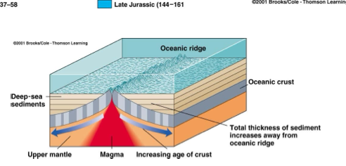
Plate Tectonic Theory Fundamentals
Described as a simple Earth model, encompassing:
A rigid outer surface (lithosphere) sitting atop a partially molten middle layer (asthenosphere).
Mantle convection drives plate movements, facilitating the formation of new crust along oceanic ridges.
Mechanisms of Plate Interaction
Plates interact along defined boundaries, categorized as:
Divergent boundaries: Where plates separate (oceanic ridge formation).
Convergent boundaries: Where plates collide or subduct (forming mountains and trenches).
Transform boundaries: Where plates slide past each other (resulting in faults, e.g., San Andreas Fault).
Divergence and Characteristics of Boundaries
Divergent Plate Boundaries: Typically found along oceanic ridges with oceanic spreading dynamics prominently illustrated.
Continental Rifts: Deformations that create linear seas and rift valleys, such as the East African and Rhine Valley. Splits landmasses
Convergent Boundaries & Types
Oceanic-Oceanic: Subduction forms ocean trenches and volcanic arcs.
Oceanic-Continental: The denser oceanic plate subducts under continental, forming mountain ranges like the Andes.
Continental-Continental: Collision leads to massive mountain ranges without subduction, exemplified by the Himalayas.
Transform Boundaries Characterized
Transform Faults: Remarkably significant within oceanic crust linking areas that slide past one another, producing earthquakes, e.g., San Andreas Fault.
Notable transform faults on land include the San Andreas Fault (California) and the North Anatolian Fault (Turkey).
Applications of Plate Tectonics
Seismic Activity: Plate tectonic models effectively explain earthquake distribution globally.
Volcano Distribution: Volcanoes are not randomly placed but found primarily along known plate boundaries.
Wilson Cycle Explained
Formalized by John Tuzo Wilson in mid-20th century, denoting the cyclical opening and closing of ocean basins with six defined stages:
A. Continental breakup: Initial phase with tectonic uplift leading to rifts (Ex: East African Rift).
B. Narrow seaway development: Continued rifting leading to narrow seas (Ex: Red Sea).
C. Formation of expansive ocean basins: Maturation phase leading to broader tectonic separation.
D. Subduction onset: Ocean begins to narrow; subduction roles filled.
E. Formation of continental sea: Compressed ocean basins facilitating continental closure.
F. Collision: Final stage producing high mountain ranges following continental collision (Ex: Himalayas).
Tectonic Cycle Concerns
Super-continent Dynamics: Evidence suggests supercontinents as early as Late Archean (2.5 billion years ago).
Notably recognized is Rodinia, forming 1.3-1.0 billion years ago and fragmenting approximately 750 million years ago, leading ultimately to Pangaea.
Natural Resource Distribution & Effects of Plate Tectonics
Significant mineral deposits correlate with plate boundaries, facilitating the presence of crucial resources (Gold, Copper, Lead, etc.) along convergent and divergent margins (Ex: Copper deposits along western coastlines).
Plate Tectonics and Evolution
The influence on biodiversity: plate movements and geological evolution create distinct provinces, influencing organism distribution and diversity via changing conditions in climate, landforms, and habitats.
Rock Cycle Relations
The interconnections between geological processes impact rock formation:
Igneous, Sedimentary, and Metamorphic Rocks: Each type can transform into another through various geological processes, demonstrating the complex interplay within the Earth's crust.