Plate boundaries + Volcanoes
- Describe the Earth’s structure·
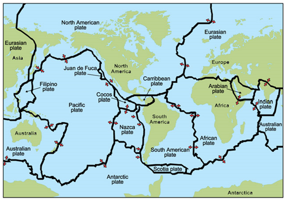
- Describe the global distribution of plates·
- Describe and explain (using diagrams) the four differing inter plate boundaries·
- Describe the main features of a volcano and why people live nearby·
- Describe and explain the causes, impacts and responses of a volcanic eruption Case Study 11: Soufriere Hills Volcano, Montserrat·
- Describe the main features of earthquakes·
- Describe and explain the formation of a tsunami·
- Describe and explain the causes, impacts and responses of an earthquake Case Study 12: Port au Prince, Haiti, Caribbean·
- Describe the differing ways of using Prediction, Protection and Preparation (3Ps) to mitigate the effects of earthquakes and volcanoes.
Structure of the Earth
- Label the differing layers of the Earth
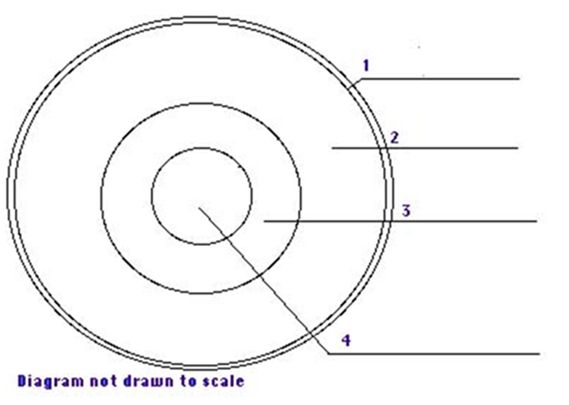
- Crust
- Mantle
- Outer core
- Inner core
Key definitions:
| The crust | is a thin rocky layer at the surface |
|---|---|
| Plate boundaries | are where many earthquakes happen |
| The core | is made of iron and lies at the centre |
| The mantle | is between the crust and the core |
| Oceanic plates | are under the oceans |
| Continental plates | carry the continents |
| Asthenosphere | This is where convection currents occur |
| Lithosphere | Comprises the upper mantle and crust |
- The centre of the Earth is hard or soft and at what temperature?
-----> 5500 degrees centigrade
2. What occurs in the asthenosphere to make plates move?
---> convection currents
- Name the two differing types of crust and give three differences between them Oceanic and continental
Types of crust:
Oceanic
- new
- can be destroyed and created
- More dense so it subducts
- More thinner
Continental
- old crust
- less dense
- thicker.
Distribution of Earthquakes and Volcanoes
- Describe the distribution of earthquakes and volcanoes on the world map below.
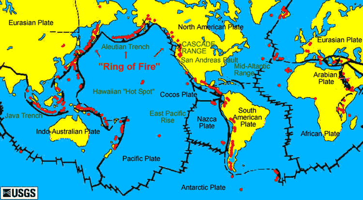
- Look at the map below and complete the table
| Interplate Boundary | Name of Plates | Landform |
|---|---|---|
| Diverging Constructive(Moving away) | North American and Eurasian Plates | Mid Atlantic Ridge |
| Converging Destructive(Coming together) | South America and the Nazca | Andes-- Fold mountains. Peru-Chile trench. V. Misti |
| Collison(collide and go up) | Eurasian and the Indian plate | Himalayas (fold mountains) |
| Conservative(sliding together) | North America and pacific plate | San Andreas Fault |
Types of plate boundaries
Conservative plate boundary:
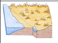
Plate movement and type of plates involved:
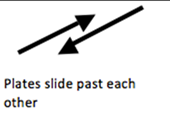
Description of what is happening at the plate boundary:
Plates slide past each other (or at differing speeds) and lock. The pressure builds up suddenly they jolt as they snap loose. Shockwaves cause shallow focus earthquakes to occur.
Hazards found:
Earthquakes only
Example of plate movement:
Pacific and North American Plates in same direction but differing speeds causing the San Andreas Fault.
Collision plate boundary

Plate movement and type of plates involved:
- 2 continental plates pushing against eatchother
Description of what is happening at the plate boundary:
Convection currents in the asthenosphere move two continentals plates together
Hazards found:
Example of plate movement:
Indian plate (continental) converging with the Eurasion plate (continental)
Diverging Constructive plate boundary:
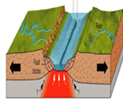
Plate movement and type of plated involved:
North America and the Eurasian plate moving apart (2 continental plates moving apart, could be 2 oceanic)
Description of what is happening at the plate boundary:
Convection currents in the asthenosphere move two plates apart causing magma to upwell and create a mid-ocean ridge
Hazards found:
Earthquakes and Volcanoes
Example of plate movement:
Eurasian and North American continental plates moving apart creating the Mid Atlantic Ridge
Converging Destructive plate boundary:
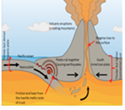
Plate movement and type of plates involved:
Nazca oceanic plate subducting the South American continental plate (oceanic plate sinking under continental crust)
Description of what is happening at the plate boundary:
An oceanic plate collides with a continental plate and subducts under it as it is more dense. The friction from this causes melting of the oceanic plate and this can lead to earthquakes and/or volcanic eruptions. The folding of the plates can create mountains as well.
Hazards found:
Earthquakes and volcanoes.
Example of plate movement:
Trench is the Peru-Chile Trench, Volcano (composite) is Volcano Misti and the Fold Mountains are the Andes Mountains.
Label a volcanoe:
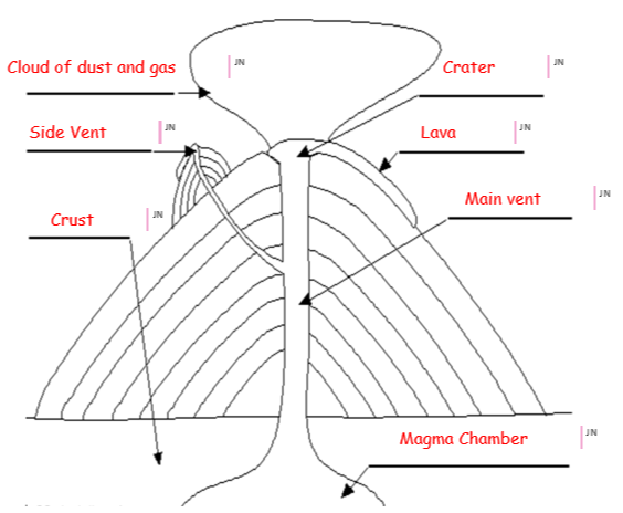
Volcanoes
- Label the volcano below with the following:
| Name | Shield Volcano | Composite/strato Volcano |
|---|---|---|
| Diagram | 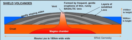 | 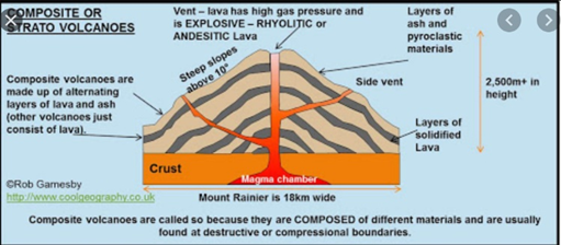 |
| Plate Boundary | Diverging Constructive | Converging Destructive |
| Lava Type & Silica Content | Basic Lava with a low silica content | Acid Lava with a high silica content |
| Eruption frequency | High | Low |
| Eruption Type | Small | Big |
| Height | Low | Tall |
| Width | Very wide | Narrow |
| Steepness | Shallow (not steep) | Steep |
| Example (plate boundaries) | Eurasian and North American continental plates moving apartcreating the Mid Atlantic Ridge creating the shield volcano MAR | Nazca oceanic plate subducting the South American continental plate creating the composite Volcano Misti |
CASE STUDY VOLCANO: Soufriere Hills, Chances Peak, Montserrat
| Background (name and locate, year etc.) | Soufriere Hills is located on the island of Montserrat which is an island in the Caribbean off the Gulf of Mexico. Montserrat is located above a converging destructive plate boundary where the South American plate is subducting the Caribbean plate. The eruptions took place in 1995. |
|---|---|
| Causes of the volcanic eruption (include type of volcano and plates and inter plate boundary) | Montserrat is located above a converging destructive plate boundary where the South American plate is subducting the Caribbean plate. The denser oceanic plate is forced down under the less dense continental plate as they are being dragged by convection currents in the asthenosphere Friction from the movement creates heat and as the oceanic plate is dragged further down into the Benioff zone it is destroyed and returns back to magma The hot magma tries to rise to the surface through weaknesses in the continental plate. When it does, it creates a volcano such as the Soufriere Hills in Montserrat |
| Primary Impacts X3 | - 23 deaths and over 100 injured. - High % of homes, businesses and important infrastructure destroyed. Plymouth (capital) covered in ash and main airport and port closed. - 75% of the island was covered in ash. southern third of island was evacuated and all public services including government had to moved to the north part of island |
| Secondary Impacts X3 | - Northern part of the island has now been redeveloped with new homes and hospitals and schools Overall population has fallen due to lack of jobs and uncertainty of another eruption (gone from 11000 to 5000 population) - Ongoing problems of respiratory disease. - Serious skills shortage due to emigration. Fears of over-dependence on UK ‘handouts’ |
| Short term Management X3 | - 5,000 people evacuated to the safe zone to the north of the island from towns such as Salem.- Plymouth Royal Navy sent ships to evacuate 4,000 people to nearby Antigua.- Islanders were offered £2,500 each to relocate to live permanently in the UK. |
| Long Term Management X3 | - Permanent monitoring stations measuring volcanic activity all over the island. - The island is promoting ‘volcano tours’ in an effort to attract tourists back to Montserrat. However, only 20- seater planes are allowed to land at the new airport so this is proving difficult. - UK sent £41m in relief aid and a further £75m to assist long term development. |
Key definitions:
| Anatomy of an Earthquake | An Earthquake is the shaking of the ground caused by |
|---|---|
| Fault | A fracture in the rocks that make up the Earth’s crust. |
| Epicentre | The point at the Earth’s surface directly above the focus. |
| Focus | The point within the Earth where an Earthquake rupture starts. |
| Focus Depth | Deep focus – subduction zonesShallow focus – constructive and collision margins |
| Plates | Massive rocks that make up the outer layer of the Earth’s surface and whose movement along faults trigger earthquakes. |
| Seismic Waves | Waves that transmit the energy released by an earthquake. |
| Magnitude | The power of the seismic waves |
3 Ps definitions
| Prediction | trying to forecast when an event (earthquake/eruption) will happen | Putting laser beanms across a fault line to detect any small movement Monitoring release of radon gas Monitoring water levels Using seisometers Watching for strange animal behaviour |
|---|---|---|
| Protection | constructing building so that they are safe, to an appropriate standard and using designs to withstand movement | Stop fridges and cookers from rolling by bolting them to the kitchen floor. Strap bookcases to walls to prevent overturning. Ensure that all doors have good latches to stop them from flying open. Flexible gas and water pipe fittings to all appliances to avoid ruptures during ground movement. Steel frames on buildings enabling sway when earthquakes occur Ribber shock absorbers at the base of buildings to let them roll Birdcage interlocking frames so that buildings can move within each other |
| Preparation | organising drills and codes of practise so that people know what to do in case of emergency e.g. hospitals, emergency services and inhabitants practising for major disaster | Local/National emergency drills – see Japan. Duck, cover, hide Dedicated areas for evacuation that are empty Emergency services have practised what to do Earthquake survival kit Roads and bridges built to withstand earthquake tremors Not build tall buildings close to each other… |
CASE STUDY EARTHQUAKE: Christchurch, New Zealand
| Background (name and locate, year, why Haiti so vulnerable etc.) | New Zealand is located in the Pacific Ocean in the continent of Oceania. It is South East of Australia and consists of a North and South Island. Its capital city is Wellington. Christchurch is geographically located on the east coast on the south island. The 6.3 magnitude earthquake struck New Zealand at 12:51 on 22 February 2011. It followed the 2010 earthquake. The epicentre was 6 miles South East of Christchurch and the focus was very shallow at 3.1 miles. |
|---|---|
| Causes of the earthquake (include plates and inter plate boundary) | The earthquake occurred on a conservative plate margin where the Pacific Plate slid past the Australian Plate in the opposite direction. Overtime there is a build-up of pressure and suddenly released the plates jerk sending huge seismic energy out creating an earthquake The 6.3 magnitude earthquake struck New Zealand at 12:51 on 22 February 2011. It followed the 2010 earthquake. |
| Primary Imapcts X3 | - 181 people were killed and around 2,000 people were injured. - 100s kms of water and sewage pipes were damaged - 50% of Central City buildings severely damaged including the city’s cathedral which lost its spire 80% of the city was without electricity |
| Secondary Impacts X3 | - Christchurch could no longer host Rugby World Cup matches so lost the benefits, e.g. tourism and income, - they would bring Damage to roads through liquefaction made it difficult for people and emergency services to move around Schools had to share classrooms because of the damage to other school buildings |
| Short term Management X3 | - Chemical toilets were provided for 30,000 residents Areas were zoned (green, orange, white, red) to classify damage/cost of repairs - International aid was provided in the form of money (around $6-7 million) and aid workers |
| Long Term Management X3 | - Paid $898 million in building claims Provided temporary housing and ensured all damaged housing was kept water tight Roads - Houses were cleared of silt from liquefaction by August and 80% of roads/50% of footpaths were repaired |