Climates
Climate is the average weather of a large region over 30-35 years.
Factors affecting climate:
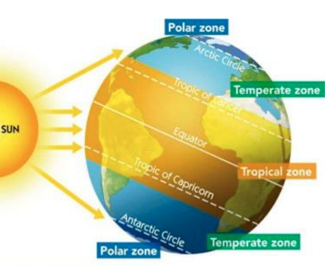
Latitude is the distance from the equator. It is described using angles.
Equator
Places near the equator receive the most heat. This is because the sun shines directly overhead.
The rays of sun have less distance to travel before they reach the surface, so the temperatures are hotter here.
Places near the poles receive less heat, as the sun shines at an angle.
The sun's energy is spread more thinly over a wider area compared to the equator.
Away from equator
Places near the poles receive less heat, as the sun shines at an angle.
The sun's energy is spread more thinly over a wider area compared to the equator.
Poles
At the poles, the sun's energy has to pass through more atmosphere.
This means more of its energy is lost before it reaches the surface.
Distance From Seas and Oceans
● Land heats up quickly in the summer.
● Land cools quickly in the winter.
● The sea heats up slowly in the summer.
● The sea cools slowly in the winter.
● This means places near the sea are cooler in the summer, than places inland.
● This means places near the sea are warmer in winter, than places inland.
Temperature range is the difference between the highest and lowest temperature. E.g: Corks temperature range is 8 degrees.
Example
Cork and Warsaw should have the same climate because they both lie on the same line of latitude.
However, because Cork is located near the sea (maritime climate), it has a smaller temperature range, 8 degrees.
Warsaw’s (continental climate) temperature range is 23 degrees.
Prevailing Winds
The prevailing wind is the most common wind blowing over a region.
Winds are named after the direction the blow from.
Ireland's prevailing wind is south-westerly.
Large masses of moving air.
These air masses influence the temperature and precipitation of the area they blow over.
Northerly winds
High latitudes, near the poles, cold, usually dry winds.
South-Westerly Winds
From over the Atlantic. Cool in the summer. Warmer in the winter. Temperate conditions. Warm winds absorb moisture as they pass over the Atlantic, so they bring rain.
Easterly Winds
From over Europe. Warm in the summer, cold in the winter. Usually dry winds. Blow over land, so no moisture.
Southerly Winds
Lower latitudes (near the equator). Warm. Bring precipitation because they cool down and lose moisture when they move from lower to higher latitudes.
Hot Climates of the World
Most hot climates are found between latitudes 30°N and 30°S. They include hot desert climates, equatorial climates and savanna climates.
Equatorial Climates
Countries | Nigeria, parts of Brazil & Peru and Indonesia. |
|---|---|
Temperature | 32°C |
Precipitation | Generally every afternoon because of high humidity, 2000mm |
Wildlife | Rain forests, jungles, mahogany, teak, cherry trees |
Vegetation | Parrots, snakes, monkeys and butterflies |
Hot Desert Climates
Countries | Sahara Desert, the Kalahari Desert, the Arabian Desert and the Australian Outback |
|---|---|
Temperature | Day: 30°C- 50°C |
Precipitation | 250mm- 100mm |
Wildlife | Camels, desert fox, rattle, tarantulas, vultures |
Vegetation | Cactus, palm, yucca |
Savanna Climates
Countries | northern parts of Australia, Madagascar, Mali, Venezuela, parts of Brazil |
|---|---|
Temperature | 25°C−35°C all year round |
Precipitation | very dry with an average annual total of over 800mm |
Wildlife | scattered trees and grassland |
Vegetation | Herds of cattle, lions, cheetahs and giraffes |
Desertification
Desertification means turning land into desert. It occurs when desert conditions spread into areas that were once fertile.
• The areas most affected by desertification are those at the edge of existing deserts.
The Sahel for example, a region at the southern edge of the Sahara Desert.
Causes of Desertification
Climate change
Rainfall is unreliable
Higher temperatures
Severe droughts
Rivers dried up
Human factors
Overgrazing of the land
No fertilisers
Results of Desertification
Hundreds of thousands of people have died as a result of famine.
Millions of people were forced to migrate in search of food or aid. Many of these still live in refugee camps.
Many people moved into urban areas, leading to the growth of slums.
Millions of animals have died.
Vast areas of land are now unable to support agriculture.
Towns and villages have been swallowed up by the advancing sands.
Solutions to Desertification
Slow down soil erosion by planting trees as shelter belts.
Bind the soil particles by planting grasses that are resistant to droughts.
Dig deeper wells to find water for irrigation.
Introduce new breeds of animals to produce more milk, but with smaller herds.
Temperate Climates of the World
Most temperate climates are found in the mid- latitudes. They include warm temperate oceanic climates and cool temperate oceanic climates.
Cool Temperate Oceanic Climates
Countries | Chile, Ireland, Norway, New Zealand and the United Kingdom |
|---|---|
Temperature | Summers: 15°C−17°C Winters: 4°C−6°C |
Precipitation | 700 and 2,000mm. The weather is cloudy and changeable |
Vegetation | deciduous forests, oak, ash, elm and willow trees |
Warm Temperate Oceanic Climates
Countries | Southwestern California, central Chile, southwest South Africa, southwest and southeast Australia, regions around the Mediterranean Sea, Italy, Spain and Greece |
|---|---|
Temperature | Summer average around 30°C and 7°C−11°C in Winter |
Precipitation | 400 and 700mm. |
Vegetation | Evergreen woodland which include cypress, cedar and olive trees. Overgrazing has damaged the scant vegetation and the soil has been exposed to erosion by sudden downpours of rain. |
Cold climates of the world
The cold climates of the world are found mainly in the northern hemisphere because, apart from Antarctica, there is no matching landmass in the southern hemisphere. They include tundra climates and boreal climates.
Tundra Climates
Countries | northern Alaska, Canada and Russia as well as Lapland in Finland, Greenland and Iceland |
|---|---|
Temperature | Summers (Short and dry): 5°C Winters (Long and cold): −24°C. |
Precipitation | 250mm |
Wildlife | very little vegetation due to the extreme cold. heathers, mosses and lichens. |
Vegetation | Snow leopards and polar bears |
Boreal Climates
Countries | southern Alaska, central Canada, most of Sweden, Finland and central Russia |
|---|---|
Temperature | Summers (short but unlike tundra climates, they are rather mild because they have long hours of daylight): 10°C−15°C. Winters (long and cold but slightly warmer than tundra climates) −13°C |
Precipitation | 400mm |
Wildlife | evergreen forests called taiga which have coniferous trees |
Vegetation | Minks, bears, wolves and eagles |