AP Human Geography 4.4 - 4.5
Borders change, people can want new land due to their connections to the land
note to self: rivers are bad boundaries because they can change currents over time, making them prone to creating border conflicts.
Countries establish boundaries by:
- defining
- delimiting
- demarcating
- defending
When defining borders, countries explicitly state where the border is located and use natural landmarks as well as latitude and longitude measurements to define these boundaries, these descriptions are then written on the official document
TL;DR defining borders is using natural landmarks to point out where the border is in a legal document
defined boundaries are straightforward and interested parties agree on them, except on the case of Belize and Guatemala
Countries delimit their boundaries by drawing them on a map in accordance with a legal agreement
TL;DR Delimiting boundaries is drawing the boundaries on a map
Demarcating boundaries - using physical objects to show the line, the boundary between the two countries
The wall between Mexico and the U.S
It’s hard to demarcate boundaries and not many countries do this
Administering borders - controlling borders, manage who passes in or out and what passes in or out
Many countries use visas to control who goes in and out
TYPES OF BOUNDARIES
geographers label boundaries by how they were created as well as their physical features
==Antecedent Boundaries== - boundaries drawn before people began to inhabit an area.
e.g. Canadian and American boundaries were drawn by British colonizers before European settlers came into these countries e.g. Malaysia and Indonesia
==Subsequent Boundaries==- Boundaries drawn after people have settled and cultural landscapes are existing, or almost existing.
==Consequent Boundaries== - A consequent boundary is a type of subsequent boundary that takes religion and culture in account when making boundaries
Think “conse” as consent
- Yugoslavia, the process of balkanization in where countries separated due to cultural differences, and the borders were drawn to where the majority of a certain ethnicity lived in.
- separation of Pakistan and India due to religious differences
==Geometric boundaries== - boundaries that are made through lines of latitude and longitude, instead of following physical and cultural features
TL;DR - boundaries made as in straight lines
geometric boundaries CAN be superimposed and have led to many conflicts, or they can also be antecedent boundaries (think of the US States, specially those of the West, that look like rectangles)
superimposed boundaries - boundaries drawn over existing borders with no regards to religion/ethnicity, these boundaries drawn by an outside conquering force
Berlin Conference 1884-1885
In the Berlin Conference, a group of major European powers held a meeting deciding how the borders in Africa will be drawn, and who those borders will belong to, creating long term conflicts as these borders separated and made opposing ethnicities come together enclosed in the borders.
==Relics== - former boundaries that became reunified, still their precense is felt even after reunification
- reunification of east and west berlin
- reunification of north and south Vietnam
SEA BOUNDARIES
Sea boundaries exist miles out to the sea
Sea boundaries are useful because they allow countries to access offshore resources such as oil and coastal sites for wind farms.
Countries with sea boundaries are more developed since the flow of ideas is easier to receive as well as imports
--> sea boundaries make it easier to conduct trade with other countries
==UNITED NATIONS CONVENTION ON THE LAW OF THE SEA (UNCLOS)== - states the structure of maritime boundaries must extend 12 nautical miles off the sea
12 nautical miles off its coast - the countries' exclusive economic zone
1 nautical mile is 1.1508 land miles
Here is a map showing the EEZs belonging to every country
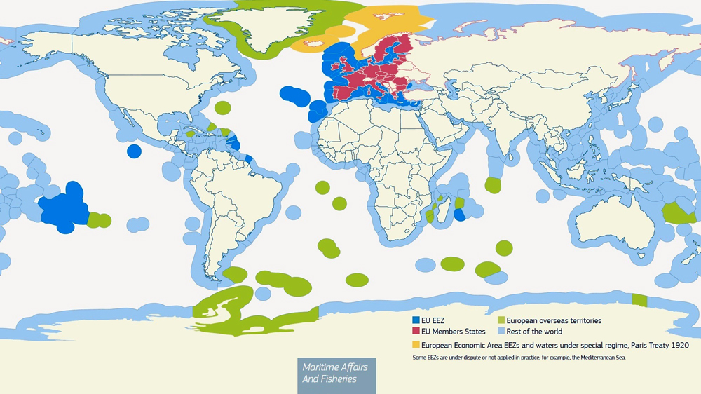
exclusive economic zones are also known as EEZ
Countries exert control over their EEZs (basically the 12 nautical miles off their coasts), they have almost a full sovereignty over these water territories, but they’re forced to allow innocent passage, meaning that they have to allow foreign ships to pass through territorial waters that as long as they aim to go to another location and nonstop direct travel
Though they do not have full sovereignty over their EEZs they have full access to the resources found in the water such as oil, fish, and they have the right to generate energy from the waves, wind or currents inside the EEZs.
The UNCLOS also states that countries need to make sure to do environmental practices, avoiding overfishing and other things such as making public of any dangers to navigation that they are aware of within their EEZS.
states are required to make public any dangers to navigation that they know of within their EEZS.
China claims it wants more than its territorial waters, breaking the 200 nautical mile rule -- in rise of this conflict claiming that they OWN that south china sea because of historical events, they decided to build artificial islands to own those waters and therefore not break the 200 nautical miles rule (these islands have military forces inside them in order to force the other countries that lay claim to the South China sea to repel. People are scared that Malaysia, Vietnam, Philippines will get angry at this and want their own share of land.