Human Geography Overview
Unit 1: Thinking Geographically
Geography as a Field of Inquiry
Cartography: The art and science of map-making.
Quantative Revolution: Use of emprical measurements, testing of hypothesese, developing mathamathical models, and use of computer programs to explain geographic patterns.
Global Positioning System (GPS): Network of satellites that orbit Earth and is used for navigation purposes.
Remote Sensing: Capturing images from airplanes or satellites.
Geographic Information System (GIS): Family of software programs which allows geographers to map, analyze, and model spatial data.
Thematic Layers: Used in GIS, a layer that contains an individual map with specific features. These layers can be combined into one cohesive layer to understand spatial relationships among different phenomena.
Human Geography: The study of human activities on Earth’s surface.
Physical Geography: Concerned with the spatial characteristics of Earth’s physical and biological systems.
Sustainability: Development that meets the need of the present without compromising the ability of future generations to meet their own needs.
Important Figures in Human Geography
-Eratosthenes: Created an accurate computation of Earth’s circumference and created the term “geography”
-Ptolemy: Published maps of landmasses and a global grid system.
-Charles Darwin: Evolution
-Carl Sauer: Believed cultural landscapes should be the fundamental focus of geographic inquiry, also that humans shaped all environments around them, even ones that seemed like natural landscapes.
-W.D. Pattison: Introduced that geography drew from 4 distinct traditions: the earth-science tradition, culture-environment tradition, locational tradition, and the area-analysis tradition.
Geography Basics
Spatial Perspective: Intellectual framework that allows people to look at Earth in terms of the relationships among various places.
Geographic Scale: A conceptual hierarchy of spaces, from small to large, that reflects levels of spatial organization in the world.
Region: An area that is larger than a city that contains some unifying social or physical characteristics. They are not well-defined units, they are conceptual constructions.
Regional Geography: The study of regions.
Functional Regions: Special identites because of the social and economic relationships that tie them together. Often referred to as nodal regions because they are defined by the connections and interactions that occur between them and surrounding areas.
Formal Regions: Specific characteristics that are relatively uniform from one place to another within the designated region (Ex. Tibet).
Perceptual Regions: Exist in the minds of people.
Sense of Place: People’s attachment to the region that they percieve as their home.
-A geographer will ask why a place occupies its space, and how it occupies that space.
Describing Location
Coordinate System: A standard grid, composed of lines of latitude and longitude, used to determine absolute location of an object or place.
Absoulute Location: Exact position of an object or place.
Longitude: The angular distance east or west of the prime meridian.
Latitude: The angular distance north or south of the equator.
Meridians: A line of longitude that runs north-south.
Prime Meridian: An imaginary line passing through the Royal Observatory in Greenwich, England, that marks the 0 degree line of longitude.
International Date Line: The line of longitude that marks where each new day begins, centered on the 180th meridian.
Site: The absolute location of a place.
Situation: The relative location of a place in relation to the physical and cultural characteristics of the surrounding area and the connections and inderdependencies within that system; a place’s spatial context.
Relative Location: The position of a place relative to the place around it.
Absolute Distance: A distance that can be measured with a standard unit of length, such as mile or kilometer.
Relative Distance: Relative distance often describes the amount of social, cultural, or economic connectivity between two places.
Connectivity: The degree of economic, social, cultural, or political connection between two places.
Time-space Convergence: The idea that distance between some places is actually shrinking as technology enables more rapid communication and increased interaction among places.
Complementarity: The actual or potential relationship between two places, usually referring to economic interactions.
Intervening Opportunities: An intervening opportunity is a feature that causes a person to choose a destination other than the original one.
Transferability: The costs involved in moving goods from one place to another.
Accessibility: The relative ease in which a destination may be reached from some other place.
Fricition of Distance: A measure of how much absolute distance affects the interaction between two places.
Distance Decay: The decrease in interaction between two phenomena, places, or people as the distance between them increases.
Gravity Model: A mathemathical formula that describes the level of interaction between two places, based on the size of their population and their distance from each other.
Law of Retail Gravitation: A law stating that people are drawn to larger cities to start businesses since larger cities have more influence on the surrounding hinterlands.
Breaking Point: Outer edge of a city’s sphere of influence, used in the law of retail gravitation to describe the area of the city’s hinterlands that depend on that city for its retail supplies.
Types of Diffusion
-Spatial Diffusion: The ways by which phenomena travel over space.
-Expansion Diffusion: The spread of ideas or phenomena to surrounding areas by exchange and contact.
-Contagious Diffusion: The spread through direct contact with another person or another place.
-Hierarchical Diffusion: A type of diffusion transmitted between places because of a physical or cultural community between those places.
-Relocation Diffusion: The diffusion from one place to another through migration.
Map Fundamentals
Aggregation: To come together into a mass, sum, or whole.
Map Scale: Ratio between distance on a map and the actual distance on Earth’s surface.
Small-Scale: Map scale ratio in which the ratio of units on the map to units on Earth is small. Small-scale maps depict large areas.
Large-Scale: Relatively small ratio between map and ground units. Large-scale maps cover smaller regions than small-scale maps.
Scale of Analysis: Geographic unit at which one investigates various patterns or processes (Ex. Nation vs. Country).
Resolution: A map’s smallest discernable unit.
-Three-dimensional shapes can never be transferred on two-dimensional surfaces without losing some detail or distorting some features.
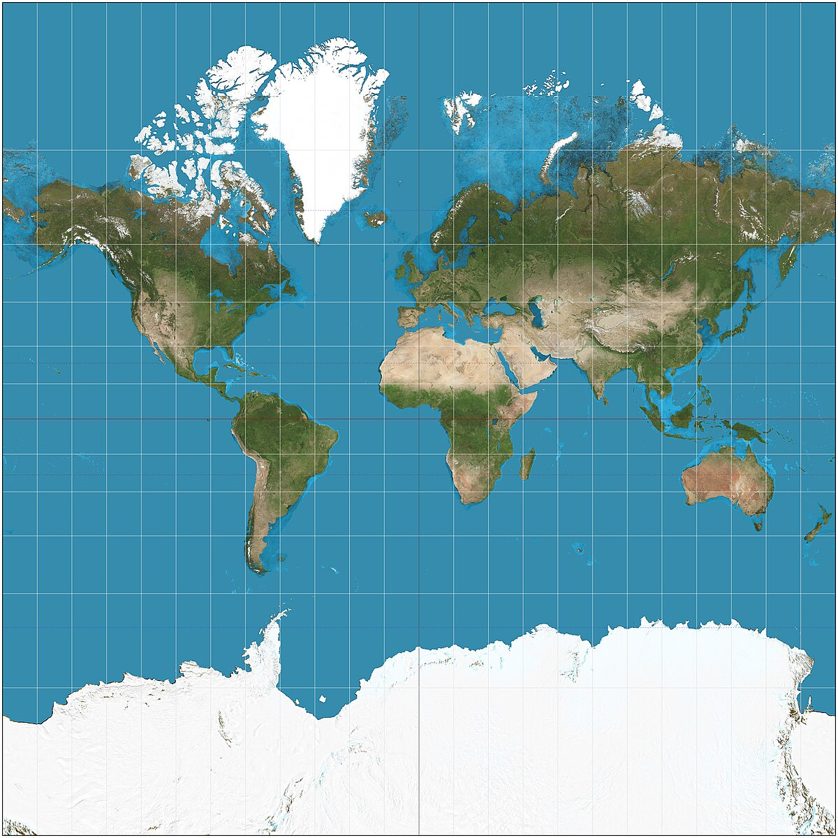 Mercator Projection
Preserves compass direction
Distorts areas of landmasses relative to each other
High latitudes become amplified (bigger)
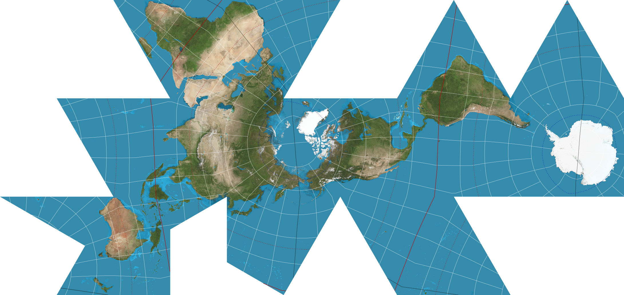 Fuller Projection
Maintains accurate size and shape of landmasses
Rearranges direction
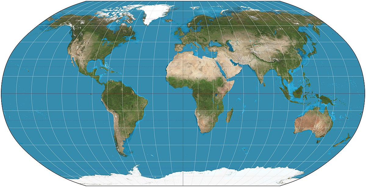 Robinson Projection
Does not maintain accurate area, shape, distance, or direction
Minimizes errors in each
Provides aesthetically pleasing balance
Commonly used by cartographers
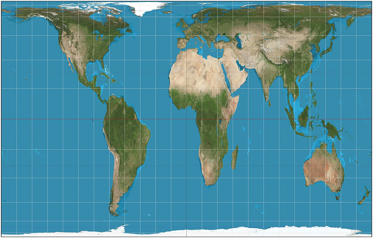 Peters Projection
Equal-area projection
Centered on Africa
Used to treat all regions equally
 Azimuthal Projection
Planar projection (formed when a flat paper is placed on top of the globe and a light source projects surrounding areas onto the map)
North or South pole oriented in the center
-It is up to the mapmaker to decide which projection to use for which purpose, no map projection is better than the others.
Types of Maps
-Reference Maps: A map type for showing reference information for a particular place, useful for finding landmarks and for navigation.
-Thematic Maps: A type of map that displays one or more variables in a specific area.
-Isoline: A map line that connects points of equal or very similar values.
-Topographic Maps: Maps that use isolines to represent constant elevations.
-Dot Maps: Thematic maps that use points to show precise locations of specific observations.
-Choropleth Maps: A thematic map that uses colors/tones to represent spatial data as average values per unit area.
-Cartograms: A type of thematic map that transforms space with the greatest value for some type of data that is represented by the largest relative area.
-Location Charts: A chart or graph on a map that gives specific statistical information.
-Proportional Symbols: A thematic map in which the size of a chosen symbol indicates the relative magnitude of some statistical value for a given region.
-Visualizations: Use of software to create dynamic computer maps.
-Cognitive Maps: An image or portion of Earth’s surface that a person creates in their mind.
-Preference Maps: A map that displays individual preferences for certain places.
 Topographic Map
 Dot Map
 Choropleth Map
 Cartogram Map
 Proportional Symbols Map
Unit 2: Population and Migration Patterns and Processes
Human Population: A Global Perspective
Population Geography/Geodemography: A division of human geography concerned with spatial variations in distribution, composition, growth, and movements of population.
Doubling Time: The time period required for a population experiencing exponential growth to double in size completely.
Demography: The study of human populations.
-80% of the world lives in less developed countries
-China and India hold 1/3 of the world's population
-Population growth is compounded
-Disease is the leading factor that led to the toppling of native cultures
Population Parameters and Processes
Total Fertility Rate: The average number of children born to a woman during her childbearing years.
Infant Mortality Rate: The percentage of children who die before their first birthday within a particular area.
Child Mortality Rate: Number of deaths per thousand children within the first five years of life.
Maternal Mortality Rate: Number of deaths per thousand of women giving birth.
Life Expectancy: The average age indivudlas are expected to live, which varies across space, genders, and races.
Crude Birth Rate: The number of live births per year per thousand people.
Crude Death Rate: The number of deaths per year per thousand people.
Natural Increase Rate: The difference between the number of births and deaths within a particular country (excludes immigration and emmigration).
Demographic Accounting Equation: An equation that summarizes the amount of growth or decline in a population within a country during a particular time period, taking into account both natural increase and net migration.
What Factors Determine a Population’s Natural Increase Rate?
-Economic Development: Improves quality of health care, employment opportunities, and nutrition. Increases in economic development can lead to a decrease in fertility and growth rate.
-Education: Populations with better education tend to have lower fertility and lower natural increase rates.
-Gender Empowerment: When women have more political and economic access to power and education, fertility rates will drop.
-Health Care: Health care can decrease infant mortality rate and increase life expectancy, thus contributing to population growth. It can also provide family planning and contraception as well, which decreases population growth.
-Cultural Traditions: Cultural traditions can encourage high fertility rates.
-Public Policy: Governments can create policies to limit or encourage population growth (Ex. China’s One Child Policy).
Human Migration
Migration: A long-term move of a person from one politcal jurisdiction to another.
Emigrate: The process of moving out of a particular country, usually the country of origin.
Immigrate: The process of individuals moving into a new country with the intention of remaining there.
Push Factors: Incentives for potential migrants to leave a place, such as harsh climate, economic recession, or political turmoil.
Pull Factors: Attractions that draw migrants to a certain place, such as a pleasant climate and employment or educational opportunities.
Voluntary Migration: Movement of an individual who consciously and voluntarily decides to locate to a new area.
Chain Migration: The migration event in which in which indiviuals follow the migratory path of preceding friends or family to an existing community.
Forced Migration: The migration event in which individuals are forced to leave a country against their will.
Intervening Obstacles: Any forces or factors that may limit human migration.
Refugees: People who leave their home because they are forced out, not officially relocating or being enslaved.
Internal Migration: The permanent or semipermanent movement of individuals within a particular country.
Rust Belt: Northern inudstrial states of Ohio, Michigan, and Pennsylvania which were places of heavy industry, in the 1960s-1980s these places lost their economic base due to deindustrialization which left old machinery to rust.
Cotton Belt: American South used to be known by this term because cotton dominated the agricultural economy of this region. Now called the New South or Sunbelt.
Sun Belt: U.S. region, made up of southeastern and southwestern states.
-Immigrants from less developed areas make up a large portion of the populations of more developed areas
-Distant ethnic neighborhoods are formed due to chain migration
-Mexicans have migrated to the U.S. voluntarily due to economic opportunities
-Removal of Native Americans and the Atlantic Slave Trade are considered the most tragic examples of forced migration
-Asia and Africa accounted for more than 2/3 of refugees
-Internal migration patterns have an impact on the ethnic composition of large urban areas and the economic dominance of various cities and regions
-California, Texas, Florida, and New York are the most populated states in the country.
Why Do People Migrate?
-Political Issues: Armed conflict and policies of oppressive regimes can lead to migration (Ex. Pilgrims fled to the Americas due to oppressive governments, and Native Americans were forced to migrate.
-Economic Factors: Job opportunities, economic cycles of growth and recession, and cost of living can lead to migration.
-Environmental Issues: This can be the case for both MDCs and LDCs. In African countries, nomadic herders leave their lands to find more fertile areas. In North America, urbanites tend to move to small rural areas to find clearer air, cheaper houses, and less traffic.
-Cultural Issues: People will move to places where they feel more at home or where they can take advantage of certain institutions (Ex. The Jews after the Holocaust relocated to Israel which was the ancestral heart of Jewish culture and religion).
-Transportation Routes: Improved transportation encourages people to migrate to other areas.
Population Structure and Composition
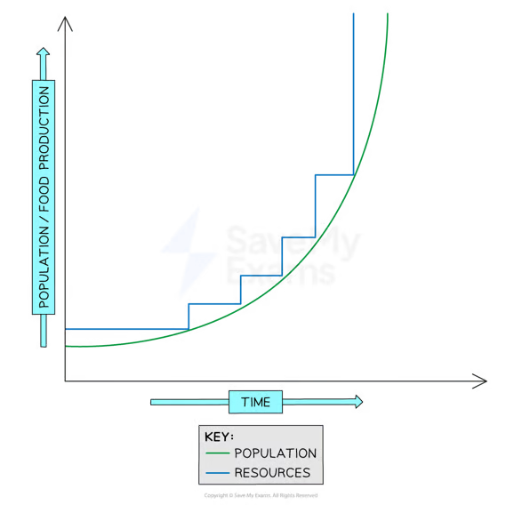
Thomas Malthus: Claimed that population grows at an exponential rate while food production increases arithmetically, thus population would outgrow food supply.
Exponentional Growth: Growth that occurs when a fixed percentage of new people is added to a population each year. Exponential growth is compound.
Neo-Malthusian: Advocacy of population-control programs to ensure enough resources for current and future populations.
Age-Sex Distribution: A model used in population geography that describes the ages and numbers of males anf females within a given population.
Population Pyramids: A model used in population geography to show the age and sex distribution of a particular population.
Baby Boom: A cohort of individuals born in the U.S. in 1946-1964, which was after World War 2. This was a time of peace and prosperity which allowed for better education, job opportunities, and high rates of marriage and fertility.
Cohort: A population group unifed by a specific common characteristic (Ex. Age).
Generation X: A term to describe people born in the U.S. between 1965-1980. This post-baby boom cohort will support the baby boom cohort.
Baby Bust: Period in the 1960s-1970s in the U.S. when fertility rates dropped as large numbers of women from the baby boom generation wanted education and jobs.
Dependency Ratio: The ratio of the number of people who are too old or too young to provide for themselves to the number of people who must support them (N:100).
Population Density: A measurement of the number of person per unit of land area.
Artithmetic Density: The number of people living in a given unit area.
Physiologic Density: The ratio of human population in an area of cropland, used in less developed countries dominated by susistence agriculture.
Carrying Capacity: The largest number that the environment can sustainably support
Overpopulation: The resoruces in a particular arae are not enough to support the area’s current population.
Zero Population Growth: Proposal to end population growth through a number of officla and nongovernmental family-planning programs.
-High population densities in Bangladesh and the Netherlands
-High population densities in the U.S. are in NY and San Francisco
Limitations of Thomas Malthus's Argument
-He did not account for the amount of food production that would increase dramatically with new technologies.
-He did not foresee population growth slowing down in the future.
-He did not recognize that famine is related to unequal distribution of food, not lack of it.
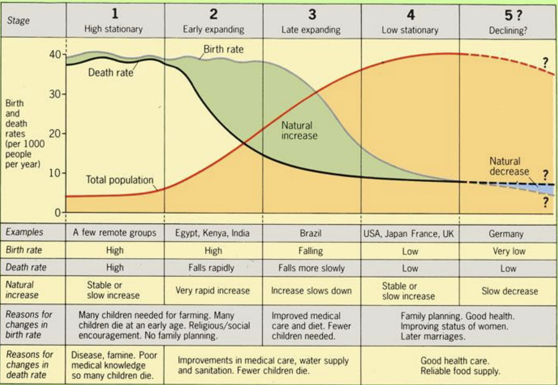
The Demographic Transition Model: A sequence of changes in which a country moves from high birth and death rates to low birth and death rates through time.
 -Geographers have stated this model to be too simplistic
-Stage 1: High birth and death rates, which cause slow population growth
-Stage 2: The death rate falls but the birth rate is still high, which causes rapid population growth
-Stage 3: The birth rate starts to fall, so population growth starts to slow
-Stage 4: The birth rate reaches the same low level as the death rate, so population growth slows to zero
The Epidemiologic Transition Model: Distinctive cases of death in each stage of the demographic transition model.
Unit 3: Cultural Patterns and Processes
Cultural Basics
Culture: A total way of life held in common by a group of people, including learned features such as language, ideology, behavior, technology, and government.
Cultural Geography: The subfield of human geography that looks at how cultures vary over space.
Ecumene: The proportion of the Earth inhabited by humans.
Customs: Practices followed by the people of a particular cultural group.
Traditions: A cohesive collection of customs within a cultural group.
Syncretic: Traditions that borrow from both the past and the present.
Cultural Traits: The specific customs that are part of the everyday life of a particular culture, such as language, religion, ethnicity, social insitutions, and aspects of popular culture.
Cultural Complex: The group of traits that define a particular culture.
Cultural Hearths: Locations of where specific cultures first arose.
Transculturation: The expansion of cultural traits through diffusion, adoption, and other related processes.
Environmental Determinism: Cultural traits are formed and controlled by environmental conditions.
Possiblism: People control their own destinies and deal with these environmental factors.
-The degree to which a culture is influenced by environmental forces depends on the level of technology prevalent within that society
Language
Language: One of the oldest, geographically diverse, and complex cultural traits.
Language Family: A collection of languages, all which came from the same original tongue long ago, that have since evolved different characteristics.
Indo-European Family: Language family containing the Germanic and Romance languages that includes languages spoken by around 50% of the world’s people.
Sino-Tibetan Family: Language area that spreads through most of Southeast Asia and China and comprises Chinese, Burmese, Tibetan, Japanese, and Korean.
Language Groups: A set of languages with a relatively recent common origin and many similar characteristics.
Romance Languages: Any languages derived from Latin, including Italian, Spanish, French, and Romanaian.
Dialects: Geographically distinct versions of a single language that vary somewhat from the particular form.
Isoglosses: Geographical boundary lines where different linguistic features meet.
Pidgin: Language that may develop when two groups of people with different languages meet. The pidgin has characteristics of each language (Hodgepodge).
Creole: A pidgin language that evolves to the point at which it becomes a primary language of the people who speak it.
Esperanto: A constructed international auxiliary language incorporating aspects of numerous linguistic traditions to create a universal means of communication.
Official Languages: Language in which all government business occurs in a country.
Polyglot: A multilingual state.
Language Extinction: This occurs when a language is no longer in use by any living people. The process of language extinction has accelerated greatly during the past 300 years.
Acculturation: The adoption of culutral traits, such as language, by one group under the influence of another.
Cultural Extinction: Obliteration of an entire culture by war, disease, acculturation, or a combination of the three.
Toponyms: Place names given to certain features on the land.
-About 5,000-7,000 languages are spoken today
-Africa and Asia are the most linguistically rich areas (have a lot of languages)
-20% of the world speaks Sino-Tibetan languages
-30% of the world speaks Afro-Asiatic, Niger-Congo, Altaic, or Austronesian
-Language diffuses through migration, trade, war, and other events that expose people who speak different languages to one another
-Creole languages typically develop in colonial settings in which the indigenous language and colonizer language mix
-Esperanto was created by Zamenhof, his goal being to create a universal second language
-Development of alphabets and literacy traditions has helped the dominance of particular cultures (The UK, France, Netherlands, Belgium, Portugal, Spain, and the U.S. had well-developed alphabets while native languages were spread vocally)
-The U.S. has no official language
-Canada is an example of a polyglot (English and French-speaking)
-Colonialism has driven languages to premature extinction
-Language can provide clues to various historical human migration patterns through the study of the assimilation of certain words across differing cultural groups
-Movements have begun to revive lost aspects of culture (Scotland, Ireland, and Wales, Celtic is being brought back, Hebrew was revived after World War 2, and Native Americans are reviving their languages)
-The various ways different cultures have named land throughout history can provide insights into historical cultural migration patterns and diffusion processes
Religion
Universalizing Religions: Religion that seeks to unite people from all over the globe.
Local Religions: Religions that are spritually bound to particular regions.
Evangelical Religions: Religion in which an effort is made to spread a particular belief system.
Missionaries: A person of a particular faith who travels in order to recruit new members into the faith represented.
Monothetistic: The worship of only one god.
Polytheistic: The worship of more than one god.
Global Religions: Religion in which memebers are numerous and widespread and hose doctrines might appeal to different people from any region of the globe.
Ethnic Religions: Religion that is identified with a particular ethnic or tribal group and that does not seek new converts.
Animism: Most prevelant in Africa and the Americas, doctrine in which the world is seen as being infused with spiritual and even supernatural powers.
Denominations: A particular religious group, usually associated with differeing Protestant belief systems.
Pilgrimage: A journey to a place of religious importance.
Fundamentalism: The strict adherence to a particular doctrine.
-Religion is tied to all aspects of human culture and social systems
-Religion can help us understand population growth, international politics, and the design and structure of cities
-All religions share a set of teachings that imply a value system, they all include the notion of the sacred, and they all include ideas about the place of human beings in the universe.
-Christianity, Islam, and Buddhism are global religions
-Fundamentalism has resulted in religious division and conflict
-Islamic fundamentalism is associated with 9/11
-In Jerusalem, Christians, Muslims, and Jews share a sacred space (Wailing Wall, Dome of the Rock, and The Church of the Holy Sepulchre)
-Sacred spaces in the landscape include, temples, synagogues, churches, mosques, or cathedrals
-The spatial distribution of these sacred spaces can help us determine which belief system is prevalent in certain areas, they also provide clues with architectural style
-Conflict in the Middle East between the Palestinians and the Jewish Israelites
Christianity
-Most widely spread religion
-Monotheistic religion
-Origins in Judaism
-Three major categories: Roman Catholic, Eastern Orthodox, and Protestant
-Baptists, Episcopalians, Lutherans, Methodists, Mormons, and Presbyterians make up Protestant denominations
-Roman Catholic most important in North America and Western Europe, and is dominant in Central and South America
-Mormons in Utah, Baptists in the South
-Eastern Orthodox is in Eastern Europe and Russia
Islam
-Monotheistic religion
-Stemmed from Judaism
-Five Pillars of Islam: Prayers 5 times daily, facing Mecca, observance of Ramadan, almsgiving, and a pilgrimage to Mecca
Buddhism
-Buddhism splintered from Hinduism.
-Appeared in India as a reaction to Hinduism’s social hierarchy.
-Prince Siddhartha founder, owned kingdom in Nepal.
Hinduism
-Ethnic religion
-Tied to Indian culture
-Caste System: System in India that gives every Indian a particular place in the social hierarchy from birth. Individuals can improve the position they have in the system in their next life through their actions and karma. After lives of good karma, they will win their place in heaven.
-Follow the doctrine of Ahimsa
Judaism
-First major monotheistic religion
-Ethnic religion
-Jewish people either live in the U.S. today or in Israel
Gender
Gender: Social constructs and cultural practices that vary across space and time.
Gender Inequality Index (UN Index): A UN Index, which measures a country’s loss of achievement due to gender inequality, based on reproductive health, employment, and general empowerment.
-Gender remains an important factor in determining access to health care, civil rights, welfare, security, and other forms of social and political equality
-Gender roles vary both historically and geographically
-Men score higher than women in areas such as income and literacy, while women score higher in life expectancy
-Gender differences seem to be the least in the core countries, while they are the most in periphery countries
-The gender component of economic development is more important in determining a population’s growth
Ethnicity
Ethnicity: Refers to a group of people who share a common identity.
Race: A group of human beings distinguished by physical traitsm blood types, genetic code patterns, or genetically inherited characteristics.
Ethnic Cleansing: The systematic attempt to remove all people of a particular ethnicity from a country or region either by forced migration or genocide.
Genocide: A premediated effort to kill everyone from a particular ethnic group.
Multicultural: Having to do with many cultures
Minority: A racial or ethnic group smaller than and differing from the majority race or ethnicity in a particular area or region.
Ethnic Neighborhoods: An area within a city containing members of the same ethnic background.
Ghettos: A segregated ethnic area within a city.
Diaspora: People who come from a common ethnic background but who live in different regions outside of the home of their ethnicity.
-Ethnicity involves a person’s social and cultural identity
-Over 90% of the world’s countries contain more than one ethnicity
-The U.S. has become multicultural, Hispanics, Asians, and other minority ethnic groups are now a part of a culturally diverse, polyglot nation in which a clear ethnic majority doesn’t exist anymore
-Examples of ethnic neighborhoods in America are “Chinatowns” in New York, Chicago, and San Francisco
-Clustering occurs from chain migration
-Some ethnic groups are forced to live in segregated parts of the city, which are called ghettos
Popular Culture
Indigenous Culture: Refers to a constellation of cultural practices that form the sights, smells, sounds, and rituals of everyday existence in the traditional socities in which they developed.
Local Culture: A set of common experiences or customs that shapes the identity of a place and the people who live there. Local cultures are often the subjects of preservation or economic development efforts.
Pop Culture: Dynamic culture based in large, heterogenous societies permitting considerable individualism, innovation, and change; having a money-based economy, division of labor into professions, secular institutions of control, and weak interpersonal ties; and producing and consuming machine-made goods.
Cultural Imperialism: The dominance of one culture over another.
-Indigenous culture is typically rural, with strong family ties and strong interpersonal relationships which lead to a cohesive group identity
-Pop culture conveys a notion of cultural productions fueled by mass media and consumerism
-Pop culture does not reflect the local environment; it looks the same everywhere
-Popular culture is easily diffused across national boundaries, and globalization has allowed for the rapid diffusion of pop culture
-Popular culture can be seen as improving economic and educational opportunities, however, it can also be seen as dominating other traditional cultures, causing traditional cultures to be lost
Unit 4: Political Patterns and Processes
What is Political Geography?
Political Geography: The spatial analysis of political phenomena and processes.
Theocracies: A state whose government is either believed to be divinely guided or a state under the control of a group of religious leaders.
-Paul Knox states that political geography can be considered within the context of two complementary perspectives, the first perspective focuses on the impacts of economic, cultural, and physical geography on political systems, while the second perspective flips this around and views political systems as the driving force behind different countries’ economic and cultural systems
The Geography of Local and Regional Politics
State: A politcally organized territory that is administered by a sovereign government and is recognized by the international community.
Nation: Tightly knit group of individuals sharing a common language, ethnicity, religion, and other cultural attributes.
Stateless Nation: A group of people with a common political identity who do not have a territorially defined, sovereign country of their own.
Nation-State: A country whose population possesses a substantial degree of cultural homogeneity and unity.
Territorial Organization: Political organization that distributes political power in more easily governed units of land.
States’ Rights: Rights and powers believed to be in authority of the states rather than the federal government.
Federalism: A system of government in which power is distributed among certain geographical territories rather than concentrated within a central government.
Devolution: The delegation of legal authority from a central government to lower levels of political organization, such as a state or country.
Unitary States: A state governed constitutionally as a unit, without internal divisions or a federalist delegation of powers.
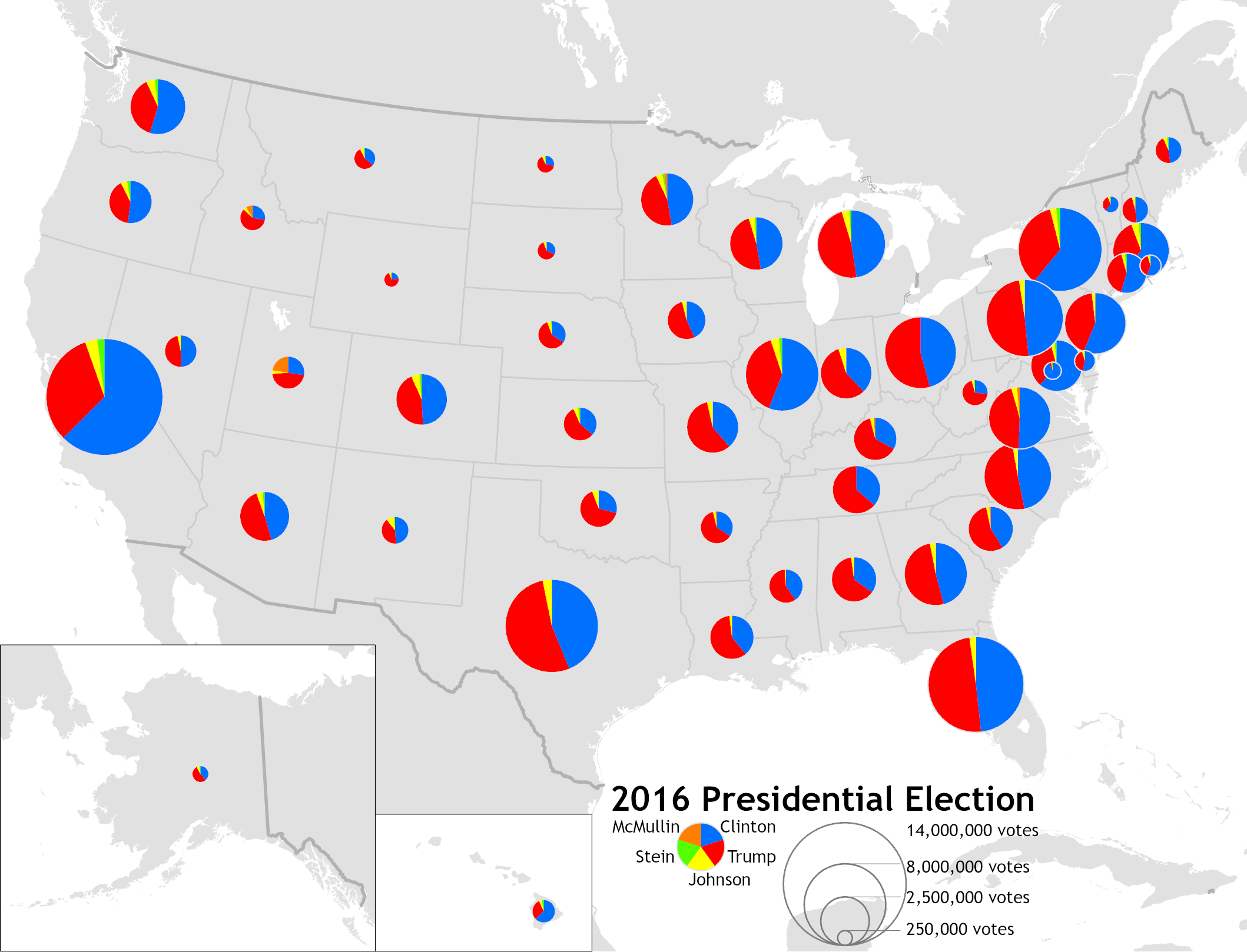
Popular Vote: The tally of each indiviual’s vote within a given geographic area.
Electoral Vote: The choice expressed collectively by the electoral college to determine the president and vice-president of the United States.
Electoral College: A certain number of electors from each state proportional to and seemingly representative of that state’s population.
Reapportionment: The process of reallocation of electoral seats to defined territories.
Redistricting: The drawing of new electroal district boundary lines in response to population changes.
Gerrymandering: The designation of voting districts so as to favor a particular political party or canidate.
-Nation-states rarely exist in the modern world
-The concept of nation-states arose in 18th-century Europe
-Many states created contain political boundaries left over from a colonial system that failed to recognize ethnic and religious boundaries, which causes states to represent themselves as unified despite having historic and cultural divides (Ex. Afghanistan, Indonesia, Rwanda)
-Territorial Organization allows for a basis for efficiently entrusting administrative functions in what would be large areas, also territorial organized governments can distribute resources to local agencies who are more in touch with the needs of the people, and national governments organized by territory give their local territories some degree of autonomy (enact laws, police lands, and tax local citizens)
-Factors that can lead to devolution are: division of groups by physical geography, ethnic separatism, ethnic cleansing, terrorism, economic and social problems, and irredentism
Territory, Borders, and the Geography of Nations
Microstates: A state or territory that is small in both population and in area.
Landlocked State: A state that is completely surrounded by the land of other states, which gives it a disadvantage in terms of accessibility to and from international trade routes.
Prorupted State: A state that exhibits a narrow, elongated land extension leading away from the main territory.
Enclaves: Any small and relatively homogenous group or region surrounded by another larger and different group or region.
Exclaves: A bounded territory that is a part of a particular state but is seperated from it by the territory of a different state.
Physical Boundaries: Political boundaries that correspond with prominent physical features such as mountain ranges or rivers.
Geometric Boundaries: Political boundaries that are defined and delimited by straight lines.
Subsequent Boundaries: Boundary line established after an area has been settled that considers the social and cultural characteristics of the area.
Antecedent Boundaries: A boundary line established before an area is populated.
Superimposed Boundaries: Boundary line drawn in an area ignoring the existing cultural patterns.
Relic Boundaries: Old political boundaries that no longer exist as international borders, but have left an enduring mark on the local cultural or environmental geography.
Centrifugal Forces: Forces that tend to divide a country.
Territorial Disputes: Any dispute over land ownership.
Balkanization: The contentious political process by which a state may break up into smaller countries.
Centripetal Forces: Forces that tend to unite a country.
Nationalism: A sense of national pride to such an extent of glorifying one nation above all the others.
Frontier: An area where borders are shifting and weak and where peoples of different cultures or nationalities meet and lay claim to the land.
Buffer States: A relatively small country sandwiched between two larger powers. The existence of buffer states may help to prevent dangerous conflicts between powerful countries.
Law Of The Sea: Law establishing states’ rights and responsibilities concerning the ownership and use of the Earth’s seas and oceans and their resources.
Colonialism: The expansion and perpetuation of an empire.
Imperialism: The perpetuation of a colonial empire even after it is no longer politically sovereign.
Self-Determination: The right of a nation to govern itself autonomously.
-The geographic location, designation of boundaries, and size and shape of territories play a large role in the state’s economy, political stability, relations with other nations, and its culture
-Russia is the largest country, in terms of land area
-Vatican City and San Mariano are known as microstates
-Larger countries sometimes tend to have more resources than smaller ones, but this is not true for Canada, Australia, and Brazil
-Geographical position can influence political and economic opportunities
-Nepal is a landlocked state and Thailand is a prorupted state
-The boundary between the United States and Canada is an antecedent boundary
-Superimposed boundaries prevailed in Africa during European colonialism
-Centrifugal forces can be caused by regionalism, ethnic strife, and territorial disputes
-Centripetal forces can be caused by strong national institutions, a sense of common history, and reliance on a strong central government
-Balkanization can occur when enclaves develop with their own ethnic identities, or when central governments devolve administrative authority to their constituent territories
-Nationalism can make some nations feel like they are superior to others, which causes conflict
-Imperialism has arisen where colonialism once flourished
-However, countries under imperialist domination have self-determination, in which people living under colonial power do not have
International Political Geography
Organic Theory: The view that states resemble biological organisms with life cycles that include stages of youth, maturity, and old age.
Geopolitics: The study of interplay between political relations and the territorial context in which they occur.
Lebensraum: Hitler’s expanisonist theory based on a drive to acquire “living space” for the German people.
Heartland Theory: Hypothesis proposed by Mackinder that held any political power based in the heart of Eurasia could gain enough strength to eventually dominate the world.
Rimland Theory: Spykman’s theory that the domination of the costal fringes of Eurasia would provide the base for world conquest.
International Organization: An alliance of two or more countries seeking corporation with each other without giving up either’s autonomy or self-determination.
United Nations: A global supranational organization established at the end of World War 2 to foster international security and cooperation.
European Nation: Supranational organization compromising Western European countries to promote free trade among members.
Supranational Organization: Organization of three or more states to promote shared objectives.
Organization of Petroleum Exporting Countries: An international economic organization whose member countries all produce and export oil.
North Atlantic Treaty Organization: An international organization of member states that have joined together for military purposes.
East/West Divide: Geographic seperation between the largely democratic and free-market countries of Western Europe and the Americas from the communist and socialist countries of Eastern Europe and Asia.
Domino Theory: The idea that political destabilization in one country can lead to collapse of political stability in neighboring countries, starting a chain reaction of collapse.
North/South Divide: The economic divison between the rich countries of Europe and North America, Japan, and Australia and the generally poorer countries of Asia, Africa, and Latin America.
Democratization: The process of establishing representative and accountable forms of government led by popularly elected officials.
North American Free Trade Agreement: Agreement signed that allowed the opening of borders between the United States, Mexico, and Canada.
-Geopolitical theories believed that nations needed to expand their land base to maintain vibrancy
-Countries in the European Union have a common currency, the euro
-A central goal of the United Nations is democratization
Unit 5: Agricultural and Rural Land-Use Patterns and Processes
Historical Geography of Agriculture
Agriculture: The art and science of producing food from the land and tending livestock for the purpose of human consumption.
Extensive Agriculture: An agricultural system characterized by low inputs of labor per unit land area.
Intensive Cultivation: Any kind of agricultural activity that involves effective and effcient use of labor on small plots of land to maximize crop yield.
Fertile Crescent: Area located in the crescent shaped zone near the southeastern Mediterranean coast, which was once a lush environment and one of the first hearths of domestication and thus agricultural activity.
Domestication: The conscious manipulation of plant and animal species by humans in order to sustain themselves.
Hunting and Gathering: The killing of wild animals and fish as well as gathering of fruits, roots, nuts, and other plants for subsistence.
Animal Husbandry: An agricultural activity associated with the rasing of domesticated animals, such as cattle, horses, sheep, and goats.
Commerical Agricultural Economies: All agricultural activity generated for the purpose of selling, not necessarily for local consumption.
Planned Agricultural Economies: An agricultural economy found in communist nations in which the government controls both agricultural production and distribution.
Captial Intensive Agriculture: Form of agriculture that uses echanical goods, such as machinery, tools, vehicles, and facilites, to produce large amounts of agricultural goods—a process requiring very little human labor.
Labor Intensive Agriculture: Type of agriculture that requires large levels of manual labor to be successful.
Slash-And-Burn Agriculture: System of cultivation that exists in tropical areas, where vegetation is cut close to the ground and then ignited. The fire introduces nutrients into the soil, making it productive for a short while.
Shifting Cultivation: The use of tropical forest clearings for crop production until their fertility is lost. Plots are then abandoned, and farmers move on to new sites.
Swidden: Land that is prepared for agriculture by using the slash-and-burn method.
Pastoralism: A type of agricultural activity based on nomadic animal husbandry or the raising of livestock to produce food, clothing, and shelter.
Industrial Revolution: The rapid economic changes tha occured in agriculture and manufacturing in England in the late 18th century.
Mechanization: The replacement of human labor with technology/machines.
Green Revolution: The development of higher yield and fast growing crops through increased technology, pesticides, and fertilizers transferred from the developed to developing world to alleviate the problem of food supply in those regions of the globe.
Specialty Crops: Crops, including items like peanuts and pineapples, that are produced, usually in developing countries for export.
Genetically Modified Organisms: Foods that are products of organisms that had their genes altered in a lab for specific purposes, such as disease resistance, increased productivity, or nutritional value, so growers have more control and can create more efficient foods.
Agribusiness: The set of economic and political relationships that organize food production for commerical purposes.
Horizontal Integration: A form of corporate organization in which several branches of a company work together to sell their products in different markets.
Vertical Integration: A form of corporate organziation in which one firm controls multiple aspects or phases of a commodity chain.
Commodity Chain: A linked system of processes that gather resources, convert them into goods, package them for distribution, disperse them, and sell them on the market.
-Agricultural lands are being lost to urban sprawl
-Before the domestication of crops, humans were involved in hunting and gathering
-Intensive has small plots of land with lots of labor to produce a lot of goods, while extensive has large plots with little labor to produce a specific item
-Boserup formalized the transition from extensive subsistence forms of agriculture to more intensive cultivation to support larger populations
 -There have been 4 pivotal periods in the history of agriculture, the first was modifying plant and animal species to sustain themselves, the second moment was with the Industrial Revolution
-During the Industrial Revolution, more people were migrating from rural to urban places and it created a market for agricultural products, furthermore, mechanization began to replace human hands, and there were also better forms of transportation
-Improved transportation allowed farmers to ship their products farther at a cheaper cost, also refrigeration allowed farmers to ship their produce even further distances
-Developed areas began to transfer new technologies for agriculture to lower-developed areas
-The Green Revolution was trying to alleviate hunger in the world, but instead, the new technology caused damage to the environment
-The topic of genetically modified organisms is debated
-Some agribusinesses include the control of the land, machinery, shipping, technology, packaging, and marketing
-Recently, agribusinesses have adopted vertical integration
Geography Of Modern Agriculture
Livestock Ranching: An extensive commercial agricultural activity that involves raising of livestock over vast geographic spaces in semiarid climates in the American West.
Dairying: An agricultural activity involving the raising of livestock, most commonly cows and goats for dairy products.
Transhumance: The movements of livestock according to seasonal patterns, generally lowland areas in the winter and highland areas in the summer.
Mediterranean Agriculture: An agricultural system practiced in Mediterrnean climates of Western Europe, California, Chile, and Australia, which produe grapes, avocados, olives, nuts, fruits, and vegetables.
Feedlots: Places where livestock are concentrated in a very small area and raised on hormones and hearty grains that prepare them for slaughter at a much faster rate than grazing.
Food Security: People’s ability to access suffcient and safe nutritious food to maintain a healthy and active life.
Biotechnology: A form of technology that uses living organisms to modifiy products, plants, and animals or to develop microorganisms for specific purposes.
-Two of the most dominant forces of modern agriculture that work to provide maximum yields for greater populations include biotechnology and agribusiness
-Periphery countries miss out on new technological advances due to not having the funds to transition
-Researchers haven’t figured out the effects that a genetically modified organism will have on a non-modified organism
-Food production differs from agricultural production because food production adds economic value to an agricultural product
-The fact that people can get any fruit or vegetable from a modern grocery store shows that there is some corporate control over agricultural goods in the developing world
Types of Commerical Agriculture
-Commercial Livestock:
It can be divided into livestock ranching and dairying
Transhumance is another practice that is used
-Commercial Grain Farming:
Includes wheat and corn
Most commercial grain farming goes toward livestock
-Tropical Plantations:
Sugarcane and coffee grown
Foreign control
Crops grown are not suited to the environment
-Aquaculture:
Fish and aquatic creatures cultivated
-Mixed And Specialty Crop Farming:
Depends on climate
Mediterranean agriculture
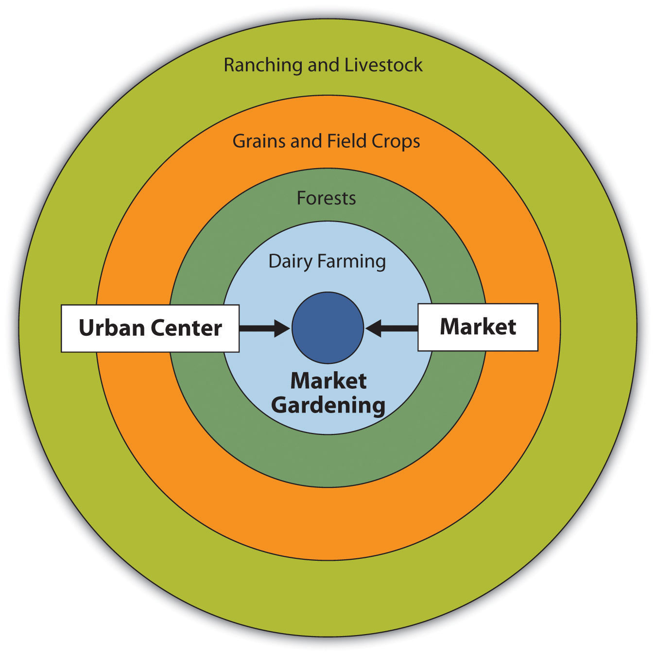
The Von Thunen Model: An agricultural model that spatially describes agricultural activity regarding rent. Activities that require intensive cultivation and cannot be transported over great distances pay higher rent to be close to the market. Conversely, more extensive activities, with goods that are easy to transport, are located farther away from the market where rent is less.
Agriculture and the Environment
Pesticides: Chemicals used on plants that do not harm the plants, but kill pests and have negative repercussions on other species that ingest the chemicals.
Topsoil Loss: When the top fertile layer of soil is depleted through erosion. It is a termendous problem in areas with fertile soils, steep slopes, or torrential seasonal rains.
Salinization: Process that occurs when soils in arid areas are brought under cultivation through irrigation. In arid climates, water evaporates quickly off the ground surface, leaving only salty residues.
Desertification: The process by which formerly fertile lands become increasingly arid, unproductive, and desert-like.
Sustainability: A set of policies or practices by which societies can ensure that the people of the future have the same access to resources and thus the same economic and environmental opportunities as people living today.
Organic Agriculture: The use of crop rotation, natural fertilizers such as manure, and biological pest control as opposed to artifical fertilizers, pesticides, hormones, antibiotics, additives, and genetically modified organisms to promote healthy, vigorous crops.
-Topsoil could take thousands of years to replace
-Agricultural land is being turned into urban spaces
-Low-intensity farms are being converted into intensive farms which turn diverse habitats into sterile environments
Unit 6: Cities And Urban Land-Use Patterns And Processes
Historical Geography of Urban Environments
Feudal Cities: Cities that arose during the Middle Ages and that actually represent a time of relative stagnation in urban growth.
Colonial Cities: Cities established by colonizing empires as administrative centers. Often they were established on already existing native cities.
Industrial Revolution: Period characterized by rapid social and economic changes in manufacturing and agriculture that occured in England in the 18th century.
Great Migration: An early 20th century mass movement of African Americans from the Deep South to the industrial North, particular Chicago.
Gateway Cities: Cities that, because of their geographical location, act as ports of entry and distribution centers for large geographic areas.
-The growth of cities was possible after people developed sedentary agriculture, which allowed them to quit farming and take up other jobs
-New York and San Francisco became gateway cities due to their proximity toward raw materials, markets, and their harbors
Culture and Urban Form
European Cities/Medieval Cities: Cities in Europe developed in the Medieval Period and retain many of the same characteristics, such as extreme density of development with narrow buildings and winding streets, an ornate church that marks the city center, and high walls surrounding the city center that provide defense against attack.
Islamic Cities: Cities in Muslim countries that owe their structure to their religious beliefs.
Squatter Settlements: Residential developments characterized by extereme poverty that usually exist on land just outside of cities that is neither owned nor rented by its occupants.
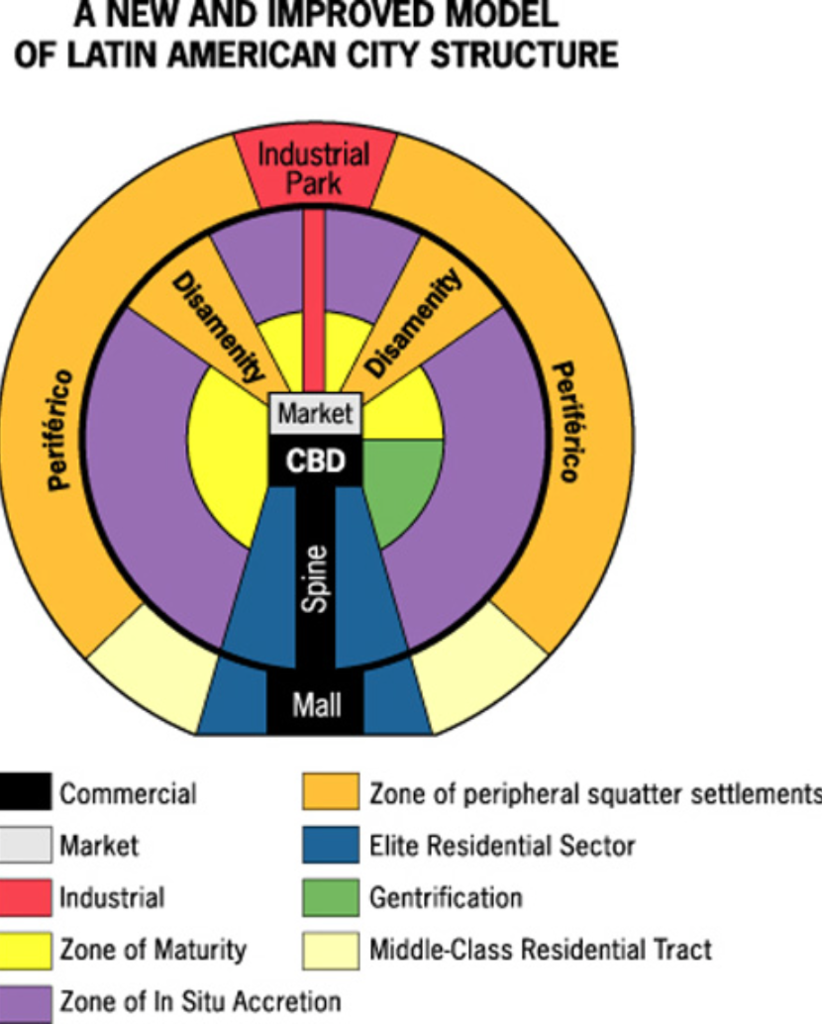
Latin American Cities: Cities in Latin America that owe much of their structure to colonialism, rapid rise in industrialization, and rapid population growth.
Central Business District: The downtown or nucleus of a city where retail stores, offices, and cultural activities are concentrated, building densities are hgih, and transportation systems converge.
Beaux Arts: Movement within city planning and urban design that stressed the marriage of older, classical forms with newer industrial ones.
City Beautiful Movement: Movement in environmental design that draw directly from the Beaux Art School. Creation of urban spaces that convyed a sense of morality and civic pride.
Modern Architecture: Modernism pursues the minimal use of design elements.
Forward Captial: A captial city placed in a remote of peripheral area for economic, strategic, or symbolic reasons.
Postmodern Architecture: Postmodernism aims to involve elements that have sentimental value.
New Urbanism: A movement in urban planning to promote mixed-used commercial and residential development and pesdestrian-friendly, community-oriented cities. New urbanism is a reaction to the sprawling, automobile-centered cities in the 20th century.
-Cities are usually the product of similar cultures and related histories
-Brasilia is a forward capital
The Spatial Organization of Urban Environments
Nodes: Geographical center of activity.
Ghettoization: A process occuring in many nncer cities in which they become dilapidated centers of pverty, as affluent whites move out into the suburbs and immigrants and people of color vie for scarce jobs and resources.
Suburbs: Residential communities, located outside the city centers, that are usually relatively homogenous in terms of population.
White Flight: The abandonment of cities by affleunt or middle-class white residents. This resulted in the loss of tax revenues to cities which then caused inner-city decay.
Blockbusting: Real estates agents encouraged white property owners to sell their homes and business at a loss of stoking fears that their neighborhoods were being overtaken by racial or ethnic minorites.
Inner-City Decay: Large parts of urban areas that lose large parts of their populations as a result of change in industry or migration to the suburbs.
Urban Revitalization: The process occuring in some urban areas experiencing inner-city decay that usually invovles the construction of new shopping districts, entertainment venues, and cultural attractions to attract urban professionals back into cities.
Gentrification: The trend of middle and upper income Americans moving into city centers and rehabilitating much of the architecture but also replacing low-income populations, and changing the social character of certain neighborhoods.
Environmental Justice: According to the US Environmental Protection Agency, the fair treatment and meaningful invovlment of all people reguardless of race, color, origin or income with respect to the development, implementation, and enforcement of environmental laws, regulations, and policies.
Urban Sprawl: The process of expansive suburban development over large areas spreading out from a city, in which the automobile provides the primary source of transportation.
Segregation: The process that results from suburbanization when affluent individuals leave the city center for homogenous suburban neighborhoods. This process isolates those indiviuals who cannot afford to consider relocating to suburban neighborhoods and must remain in certain pockets of the central city.
Edge Cities: Cities that are located on the outskirts of larger cities and serve many of the same functions of urban areas, but in a sprawling, decentralized suburban environment.
Urban Growth Boundaries: Geographical boundaries placed around a city to limit suburban growth within the city.
Metropolitian Areas: An urban area consisting of one or more whole county units, usually containing several urbanizaed areas, or suburbs, that all act together as a coherent economic whole.
Central-Place Theory: A theory formulated by Christaller that explains the size and distribution of cities in terms of a competetive supply of goods and services to disperse populations.
Hinterlands: The market area surrounding an urban center, which that urban center serves.
Exurbia: The exurbs collectively; the region beyond the suburbs.
Rank-Size Rule: Rule that states that the population of any given town should be inversely proportional to its rank in the country’s hierarchy when the distribution of cities according to their size follows a certain pattern.
Primate City: A country’s leading city, with a population that is disproportionaly greater than other urban areas within the same country.
Megalopolis: Several metropolitan areas that wre originally seperate but that have joined together to form a large, sprawling urban complex.
Megacities: Cities, mostly characteristic of the developing world, where high population growth and migration have caused them to explode in population size. They all have chaotic and unplanned growth, pollution, and widespread poverty.
Metacities: Larger than megacities, metacities describe an urban region where multiple dense areas are interspersed with suburbs and green spaces (or squatter settlements for developing areas).
World City: Centers of economic, cultural, and political activity that are strongly interconnected and together control the global systems of finance and commerce.
-American cities have undergone 5 epochs of forms of transportation, sails-wagons, iron horse, steel rail, auto-air amenity, and satellite electronic jet propulsion and high technology.
-Most world cities are located in the wealthy and industrialized countries
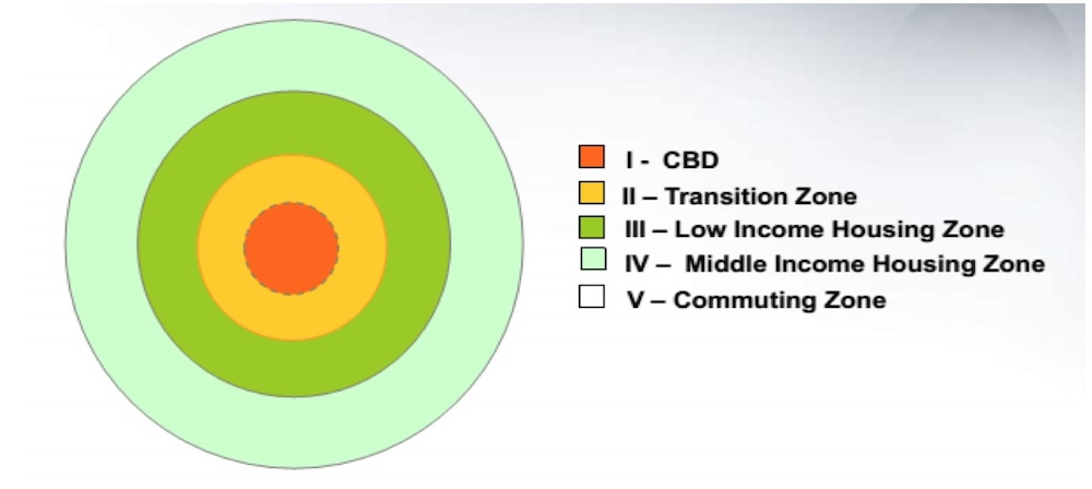
-The Concentric Zone Model: Model that describes urban environments as a series of rings of distinct land uses radiating out from a central core, or central business district.
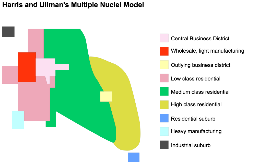
 -The Multiple Nuclei Model: A type of urban form wherein cities have numerous centers of business and cultural activity instead of one central place.
 -The Sector Model: A model of urban land use that places the central business district in the middle, with wedge-shaped sectors radiating outward from the center along transportation corridors.
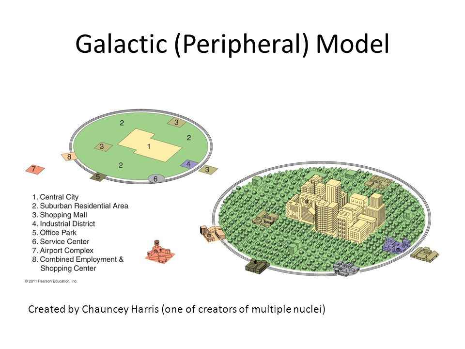
 -The Galatic City Model: The galactic city model represents a city with growth independent of the CBD that is traditionally connected to the central city by means of an arterial highway or interstate.
 Urban Planning
-Lynch classified the geographical contents of cities into paths, edges, districts, nodes, and landmarks
Paths:
-Highways
-Sidewalks
-Transit lines
Edges:
-Rivers
-Rail lines
-Large walls
-Forested places
Districts (Physical and Mental):
-CBD
-Industrial areas
-Dangerous neighborhoods
-Rich neighborhoods
Nodes:
-Junction of paths
-Visible structures
Landmarks:
-Used for directional cues within a city
Five Rules That Apply To People’s Daily Spatial Behavior
-People tend to make more short trips than long trips
-People tend to worry little about distance when moving around very close to home, but when the trip requires you to venture farther away from home, distance becomes an important factor in deciding whether or not to go.
-The longest trips tend to be work-related
-Transportation limits some spatial behaviors
-People tend to avoid perceived hazards, whether or not those hazards pose a real threat
-These rules help planners make decisions
Unit 7: Industrial and Economic Development Patterns and Processes
Industrialization
Industrialization: Process of industrial development in which countries evolve economically, from producing basic, primary goods to using modern factories for mass producing goods.
Industrial Revolution: The rapid economic and social changes in manufacturing that resulted after the introduction of the factory system to the textile industry in England at the end of the 18th century.
Specialty Goods: Goods that are not mass-produced but rather assembled individually or in small quantities.
Cottage Industries: An industry in which the production of goods and services is based in homes, as opposed to factories.
Fordism: System of standarized mass production attributed to Henry Ford.
Industrialized Countries: Countries including Britain, France, the United States, Russia, Germany, and Japan are the forefront of industrial production and innovation.
Service-Based Economies: Highly developed economies that focus on research and development, marketing, tourism, sales, and telecommunications.
Deindustrialization: Loss of industrial activity in a region.
Backwash Effect: The negative effects on one region that result from economic growth within another region.
E-Commerce: Web-based economic activities.
Brick-And-Mortar Businesses: Traditional businesses with actual stores in which trade or retail occurs; they do not exist solely on the internet.
Transnational Corporation: A firm that conducts business in at least two seperate countries. Also known as multinational corporations.
Conglomerate Corporations: A firm comprising many smaller firms that serve several different functions.
Export Processing Zones: Area where governments create favorable investment and trading conditions to attract export-oriented industries.
Maquiladoras: Cities where US firms have factories just outside the United States—Mexican border in areas that have been specially designated by the Mexican government. In such areas, factories cheaply assemble goods for export back into the United States.
Outsourcing: Sending industrial processes out for external production.
Bulk-Gaining Industries: Industries whose products weigh more after assembly than they did previously in their constituent parts. These industries have production facilities close to their markets.
Bulk-Reducing Industries: Industries whose final products weigh less than their constituent parts, and whose processing facilities tend to be located close to sources of raw materials.
Break-Bulk Point: A location where large shipments of goods are broken up into smaller containers for delievery to local markets.
Offshore Financial Centers: Areas that have been specially designed to promote business transactions, and thus have become centers for banking and finance.
-Zones that try to attract foreign investment have accessible distribution facilities, lax environmental restrictions, and attractive tax exemptions
Models of Development and Measures of Productivity
Primary Economic Activities: Economic activities in which natural resources are made available for use or further processing, inclduing mining, agriculture, forestry, and fishing.
Secondary Economic Activities: Economic activities concered with the processing of raw materials, such as manufacturing , construction, and power generation.
Tertiary Economic Activities: Activities that provide the market exchange of goods and that bring together consumers and providers of services, such as retail, transportation, government, personal, and professional services.
Quaternary Economic Activities: Economic activities concerned with research, information gathering, and administration.
Quinary Economic Activities: The most advanced form of quaternary activities consisting of high-level decision making for large corporations or high level scientific research.
Less Developed Countries: Countries in Africa, South America, and Asia have low levels of economic productivity, low capita incomes, and generally low standards of living.
Foreign Investment: Overseas business investments made by private companies.
Development: The process of economic growth, expansion, or realization of regional resource potential.
Gross National Product: The total value of goods and services, including income recieved from abroad, produced by the residents of a country within a specific time period, usually one year.
Productivity: A measure of the goods and services produced within a particular country.
Purchasing-Power Parity: A monetary measurement of development that takes into account what money buys in different countries.
Gross Domestic Product: The total value of goods and services produced within the borders of a country during a specific time period, usually one year.
Net National Product: A measure of all goods and services produced by a country in a year, inclduing production from its investments abroad, minus the loss or degredation of natural resource captial as a result of productivity.
Human Development Index: Measure used by the United Nations that calculates development not in terms of money or productivity but in terms of human welfare. It evaluates human welfare based on life expectancy, education, and income.
Gender Equity: A measure of the opportunities given to women compared to men within a given country.
-The shift from primary and secondary economic sectors to tertiary and quaternary will never achieve full completion in a country
-Development can be measured into 2 categories: economic measures and noneconomic measures (social welfare)
-GNP is a broad vision of productivity
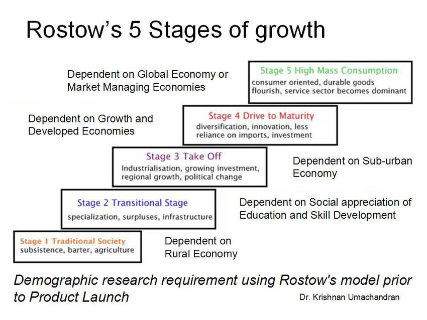
-Rostow’s Stages of Development: A model of economic development that describes a country’s progression, which occurs in 5 stages, transforming them from least developed to most developed countries.
-Rostow’s model does not account for global politics, colonialism, physical geography, war, culture, and ethnic conflict, which can cause countries to follow different economic trajectories
-Another limitation of the model is that it defines the final stage of development as mass consumption when development does not equal mass consumption
-Rostow’s model does not account for deindustrialization
 Global Economic Patterns
Core: National or global regions where economic power, in terms of wealth, innovation, and advanced technology, is concentrated.
Semiperiphery: Newly industrialized countries with median standards of living, such as Chile, Brazil, India, China, and Indonesia. These countries offer their diverse economic opportunities but also have extreme gaps between rich and poor.
Periphery: Countries with low levels of economic productivitiy, low per-capita incomes, and low standards of living. The world economic periphery includes Africa, parts of South America, and Asia.
Slow World: The developing world that does not experience benefits of high-speed telecommunications and transportation technology.
Fast World: Areas of the world, usually the economic core, that experience greater levels of connection due to high-speed telecommunications and transportation technologies.
World-System Theory: Theory developed by Wallerstein that explains the emergance of a core, periphery, and semiperipheryin terms of economic and political connections first established at the beginning of exploration in the late 15th century and maintained through increased economic access up until the present.
Location Principles
Least-Cost Theory: A concept developed by Alfred Weber to describe the optimal location of a manufacturing establishment in relation to the costs of transport and labor, and the relative advantages of agglomeration or deglomeration.
Footloose Firms: Manufacturing activities in which the cost of transporting both raw materials and finished product is not important for determining the location of the firm.
Spatially Fixed Costs: An input cost in manufacturing that remains constant wherever production is located.
Spatially Variable Costs: An input cost in manufacturing that changes significantly from place to place in its total amount and in its relative share of total costs.
Agglomeration: Grouping together of many firms from the same industry in a single area for collective or cooperative use of infrastructure and sharing of labor resources.
Ancillary Activities: Economic activities that surround and support large scale industries such as shipping and food service.
Deglomeration: The dispersal of an industry that formerly existed in an established agglomeration.
Regionalization: The process by which specific regions acquire characteristivs that differentiate them from others within the same country. It involves the development of dominant economic activities in particular regions.
Manufacturing Region: A region in which manufacturing activities have clustered together.
Economic Backwaters: Regions that fail to gain from national economic
development.
Geographic Factors That Industries Use To Locate Facilities
-The location a company chooses must provide easy access to the materials necessary for production.
-The location must have an adequate supply of labor. For some industries, inexpensive, unskilled labor is best, but for others, such as information technology, an abundance of skilled labor is necessary.
-Proximity to shipping and markets is also a key factor, especially for industries producing items that are either bulky or perishable. These items are either expensive to ship or, by their nature, time-sensitive.
-The site should be chosen to minimize production costs. Firms can minimize production costs by locating in a place with cheap land and labor. Government policies can also have an important impact on production costs.
-Natural factors, such as climate, may limit the geographical distribution of certain types of firms, such as agribusiness corporations.
-The firm’s history and its leaders’ inclinations may also influence the final choice.
Development, Equality, and Sustainability
Sustainable Development: The idea that people living today should be able to meet their needs without prohibting the ability of future generations to do the same.
Renewable Natural Resources: Any natural resource that can replenish itself in a relatively short period of time, usually no longer than the length of a human life.
Nonrenewable Natural Resources: Any natural resource that cannot replenish itself in a relatively short period of time.
Ecotourism: A form of tourism, based on the enjoyment of scenic areas or natural wonders, that aims to provide an experience of nature or culture in an evironmentally sustainable way.
Globalization
Globalization: The idea that the world is becoming increasingly interconnected on a global scale such that smaller scales of political and economic life are becoming obsolete.