Volcanoes
Distribution of Volcanic Hazards
Most active volcanoes occur at or near plate boundaries
Many (about 75%) occur around the 'Ring of Fire' surrounding the Pacific Ocean
Vulcanicity (volcanic activity) is focused on constructive and destructive plate margins
At constructive margins, eruptions tend to be small and >effusive
The eruptions are usually basaltic lava:
Low gas content
Low viscosity
Higher temperature
At destructive margins, eruptions tend to be explosive as the magma is forcing its way to the surface
These eruptions are often andesitic
High gas content
High viscosity
Lower temperature
Volcanoes can also be found at hot spots in the middle of plates, like Hawaii in the central Pacific

Examiner Tips and Tricks
It is important that you are confident to describe distribution.
What is the general pattern?
Does the pattern relate to anything else for example the location of plate boundaries?
Are they near the equator or further away?
Are they inland or coastal?
Use map features to help with your description - place names, compass rose, latitude and longitude
Magnitude of Volcanic Hazards
Some volcanic eruptions are gentle and effusive while others are hugely explosive
This is dependent on the magma composition
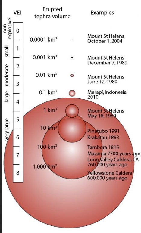
The Volcanic Explosivity Index (VEI) is used to measure the magnitude of an eruption
This is a logarithmic scale from 0-8
It cannot be measured on a scientific instrument so is calculated based on a series of measurements and observations
These include:
Height of material ejected into the atmosphere
Volume of material
Duration of the eruption
Primary Hazards
Although they are all unique, volcanic eruptions have common hazards
Primary (a direct result of the eruption)
Secondary (a result of the primary hazards)

Diagram to show volcanic hazards
Tephra – solid material of varying sizes that is ejected by a volcano – ranges from ash (less than 2mm in diameter) to volcanic bombs (more than 64mm)
Ash fallout – large quantities of ash carried by the wind and deposited on the ground
It can travel many km, causing respiratory problems, injuries, damage, deaths and disruption to transport
E.g. the 2010 Eyjafjallajökull eruption in Iceland produced an ash cloud that disrupted air travel in Europe for several weeks

Extent of ash cloud from 2010 Eyjafjallajökull eruption
Pyroclastic flow- a super-heated mixture of gas and tephra that flows at speeds of up to 700 km per hour
This is one of the deadliest volcanic hazards as they can travel long distances and destroy everything in their path
E.g. when Fuego volcano erupted in Guatemala in 2018, pyroclastic flows destroyed several nearby towns
Lava flow – lava flows travel at different speeds depending on slope, temperature and viscosity
Most move slowly enough that they are not a risk to human life but can cause significant damage to property and infrastructure
The fastest flows can reach speeds of up to 60 mph
In the 2021 eruption of Mount Nyiragongo in the Democratic Republic of Congo, lava flows travelled almost 10km destroying properties and killing over 30 people
Volcanic gases – eruptions can release large quantities of gases such as sulphur dioxide and carbon dioxide
They are hazardous to human health causing respiratory problems and deaths
E.g. Kilauea in Hawaii (USA) releases large amounts of sulphur dioxide leading to air quality alerts and health warnings for residents
Secondary Hazards
Lahars – mudflows that occur when tephra mixes with water, either from rainfall, or from melted snow and ice
They are fast flowing and destroy everything in their path
E.g. the lahars that occurred when Mount Pinatubo erupted in the Philippines in 1991 caused extensive damage and disruption

Map to show extent of lahars in eruption of Mount Pinatubo
Jökulhlaups - floods caused by a sudden release of water and rocks when glacial ice is melted by the eruption
The 2010 eruption of Eyjafjallajökull triggered a jökulhlaup which destroyed several bridges and roads
Acid rain – forms when sulphur dioxide emitted during the eruption reacts with water vapour in the atmosphere to form sulphuric acid
It can damage crops, forests and aquatic ecosystems
Frequency & Regularity of Hazards
Volcanic eruptions occur with varying frequency and regularity depending on the type of volcano and its location
Shield volcanoes tend to be found at constructive plate margins and are typified by high frequency, low magnitude eruptions
Stratovolcanoes tend to be found at destructive plate margins and are typified by low frequency, high magnitude eruptions

Diagram of a shield volcano

Diagram of a stratovolcano
Some volcanoes erupt more frequently and regularly than others
Mount Stromboli in Italy usually erupts every 20-40 minutes
Mount Pinatubo in the Philippines had not erupted for around 500 years before its eruption in 1991
Scientists study the geological history of volcanoes (e.g. eruptions and gas emissions) to try to predict when the next eruption might occur
Volcanic eruptions can occur with few warning signs and do not necessarily follow historical patterns
Predicting Volcanic Events
There are warning signs before most volcanic eruptions
Volcanologists (scientists who study volcanoes) monitor changes using GPS, tilt meters, satellites, seismometers and gas detection
Signs of an eruption include:
Magma rising which can be detected by heat sensors and satellites
Ground deformation as rising magma causes bulges
Increased emissions of sulphur dioxide and other gases
Increased seismic activity caused by magma movement detected by seismometers

Methods of monitoring volcanoes
Examiner Tips and Tricks
It is important to be aware that while there are several methods used to monitor and predict volcanic eruptions, it is impossible to be certain about exactly when a volcano will erupt and with what magnitude. Indeed, there are many examples where even heavily monitored volcanoes have taken people by surprise.
For example, Mount Ontake in Japan erupted suddenly and unexpectedly in 2014 killing 63 people. It hadn’t shown any signs of an eruption or increased activity so no warnings or alerts were issued. Hikers and tourists on the mountain were taken by surprise and many were killed or injured.
Primary & Secondary Impacts of Eruptions
Primary impacts are the immediate effects of the hazard such as injuries and deaths, and damage to property and infrastructure
Secondary impacts are the longer-term effects of the hazard such as economic losses, social and psychological consequences
Examples of Impacts of Volcanic Hazards SEEP FACTORS
| Primary impacts | Secondary impacts |
|---|---|---|
Social | Deaths and injuries Displacement of people Damage to properties and infrastructure causing disruption to people’s lives
| Mental health issues e.g. stress, anxiety, depression Homelessness Disruption to services such as healthcare and education Loss of cultural heritage sites |
Economic | Destruction of property and infrastructure leading to significant costs for repair and reconstruction Disruption of trade and economic activity Loss of income and employment Costs of immediate responses e.g. food aid, temporary shelter, medical treatment | Slower economic growth and development Increased economic inequality as impacts are more severe for most vulnerable people Increased costs of insurance and hazard management strategies |
Environmental | Poor air and water quality Loss of biodiversity Destruction of habitats and ecosystems
| Acid rain can damage ecosystems Release of greenhouse gases can lead to a rise in global temperatures Ash clouds can lead to a fall in global temperatures due to solar energy being reflected back into space |
Political | Pressure on governments to co-ordinate emergency response Social unrest and political instability | Conflicts over government response and food shortage Changes in government policy and regulations to reduce future risk |
long-Term and short-term Responses to Volcanic Hazards
Long-term these are measures taken to reduce the impacts of future eruptions
Short-term responses usually happen immediately before, during or after a volcanic eruption
Examples of Long and Short-term Responses
Long-term responses | Short-term responses |
|---|---|
Hazard mapping and land use zoning – identifying areas at most risk and limiting the activities that can take place there Building codes – creating a set of building codes to increase the resilience of buildings to volcanic hazards Education and training – preparing communities to improve evacuation and response | Evacuation – moving people out of the danger zone around a volcano when it shows signs of erupting Search and rescue – using sniffer dogs and heat sensors to locate survivors and rescue them Emergency aid - providing food, water, medical aid to affected communities
|
Responses can also be categorised as prevention, preparedness, mitigation and adaptation

Comparison Table of Volcano Types
Feature | Shield Volcano | Stratovolcano (Composite) | Cinder Cone | Lava Dome |
|---|---|---|---|---|
Shape | Broad, gentle slopes; shield-like | Steep-sided, symmetrical cone | Small, steep conical hill | Rounded, steep-sided mound |
Lava Type | Basaltic (Low silica) | Andesitic / Rhyolitic | Basaltic / Andesitic | Rhyolitic (High silica) |
Viscosity | Low (Runny) | High (Thick) | Low to Medium | Very High (Pasty) |
Eruption Style | Effusive | Explosive | Explosive (Strombolian) | Effusive or Explosive |
Plate Margin | Constructive / Hot spots | Destructive | Various (often on flanks) | Destructive |
Frequency | High frequency | Low frequency | Often single eruption | Variable |
Magnitude | Low (VEI 0−30−3) | High (VEI 4−84−8) | Low (VEI 1−21−2) | Variable |
Structural and Design Mitigation for Buildings
To prevent significant damage from volcanic hazards, buildings can be engineered with specific design features:
Steeply Pitched Roofs: Designing roofs with a greater slope ensures that volcanic ash (tephra) slides off easily. This prevents roof collapse from the immense weight of accumulated ash, which becomes even heavier if it rains.
Reinforced Roof Strength: Using materials like reinforced concrete or heavy-duty steel to increase the load-bearing capacity of the roof against static ash loads and the dynamic impact of falling volcanic bombs.
Smooth Surface Materials: Utilizing corrugated iron or smooth tiles to reduce friction, allowing tephra to shed more efficiently.
Sealing and Filtration Systems: Installing specialized seals on windows and doors to prevent the infiltration of fine ash particles and toxic gases (SO2, CO2), which can cause respiratory failure and damage electrical systems.
Simplified Building Footprints: Minimizing roof "valleys" and complex joints where ash can naturally collect and create structural pressure points.
Strengthened Foundations: Building robust foundations to withstand the seismic tremors and ground shaking that typically accompany rising magma.
Protective Deflection Barriers: In specific locations, reinforced masonry walls or channels can be built to divert lahars or slow-moving lava flows away from residential structures.
Non-Flammable Materials: Using fire-resistant roofing and siding to protect buildings from incendiary damage caused by hot tephra or proximity to lava.