EAS 209 - Lecture 25
Alfred Russel Wallace
Alfred Russel Wallace lived from 1823–1913 and was a contemporary of Charles Darwin.
Wallace independently developed the concept of natural selection through observations made during his travels.
Like Darwin, Wallace traveled extensively and collected biological and geological observations from different regions.
Wallace recognized patterns in species distribution and adaptation that led him to propose natural selection as the mechanism driving evolution.
He wrote a letter to Darwin describing his ideas and observations.
Darwin had been developing a similar theory but had not yet published it.
After receiving Wallace's letter, Darwin became concerned that Wallace might publish first and receive priority for the discovery.
Darwin quickly prepared his own publication on natural selection.
Wallace was listed as a co-author despite not being consulted beforehand.
Historians often debate whether Wallace might have become the primary figure associated with evolution had Darwin not acted so quickly.
Unlike Darwin, Wallace did not come from a wealthy family and lacked independent financial support.
Darwin's family wealth allowed him to focus on scientific research without needing regular employment.
Wallace spent much of his life supporting himself through his work.
In later life, fellow scientists successfully petitioned the government to provide Wallace with a pension.
Wallace's scientific reputation was damaged somewhat by his involvement in spiritualism.
He strongly believed in séances, spirit communication, and related practices.
Spiritualism became popular during the nineteenth century and attracted many followers.
Wallace actively defended individuals accused of fraudulent spiritualist activities.
His support for spiritualism caused some members of the scientific community to view him less favorably.
Despite this controversy, Wallace remains one of the most important contributors to evolutionary theory.
Review: Rundle Group
The Rundle Group was deposited primarily on a clastic ramp system.
Clastic sediments originate from erosion of pre-existing rocks on land.
These sediments are transported into marine basins by rivers, currents, and other processes.
Carbonates were still present during Rundle deposition but were becoming less dominant.
Increasing sediment input from surrounding land areas led to greater accumulation of siliciclastic material.
The basin was gradually transitioning away from widespread carbonate-dominated deposition.
This shift becomes even more pronounced during the Permian.

Absaroka Sequence (Pennsylvanian–Permian)
The Absaroka Sequence represents a major depositional sequence spanning the Pennsylvanian and Permian periods.
A sequence is defined as a complete cycle of sea-level rise (transgression) followed by sea-level fall (regression).
Sea-level fluctuations controlled where sediment accumulated and where erosion occurred.
Rocks are generally preserved when covered by water because sediments can accumulate without being removed by erosion.
Rocks exposed above sea level are more likely to be eroded and therefore absent from the geologic record.
On sequence diagrams, black areas represent intervals where deposition was absent or erosion removed previously deposited sediments.
White or stippled areas represent intervals where sediments accumulated and were preserved.
During the Pennsylvanian and early Permian, sea level rose and flooded much of the basin.
During the later Permian, sea level fell again, exposing large portions of the basin.
The Permian marks the final stage of the Paleozoic Era and the latter portion of the Absaroka Sequence.
Tectonic Setting During the Carboniferous and Permian
Major structural changes occurred across western Canada during the Carboniferous and Permian.
During the Devonian, Alberta contained several prominent structural highs.
These highs included the Peace River Arch and the West Alberta Ridge.
Structural highs stood above surrounding areas and often acted as islands or shallow-water features.
During the Carboniferous and Permian, these highs subsided and became structural lows.
The Peace River Arch evolved into the Peace River Embayment.
The West Alberta Ridge evolved into the Ishbel Trough.
This transition from uplifted areas to depressed areas fundamentally changed sediment distribution patterns.
Subsiding areas created accommodation space where sediments could accumulate and be preserved.
Elevated regions experienced erosion and therefore preserve little sedimentary record from this interval.
Researchers suggest this structural collapse may be related to the Antler Orogeny occurring farther south.
The Antler Orogeny was a mountain-building event associated with tectonic compression.
Compression in one region can produce extension in adjacent regions.
Extension causes crustal thinning and subsidence.
As the crust stretched, formerly elevated structures collapsed downward.
The resulting basins became major centers of sediment accumulation.
British Columbia During the Permian
Modern British Columbia did not yet exist during the Carboniferous and Permian.
The region west of Alberta was occupied by open ocean.
Many of the crustal blocks that now form British Columbia originated elsewhere.
These crustal fragments are called terranes.
Terranes were gradually accreted onto North America during the Late Triassic and later periods.
Subduction along the continental margin carried these terranes toward North America.
Collision and accretion eventually built much of modern British Columbia.
During the Permian, however, Alberta faced an open ocean environment to the west.
Later mountain building uplifted many of these sediments.
Erosion removed large portions of the original deposits, leaving only isolated remnants preserved today.
Facies Distribution
Facies refers to the physical characteristics of sedimentary rocks that reflect their depositional environment.
Different facies develop in different environments depending on water depth, energy conditions, and sediment supply.
Permian deposits contain a mixture of siliciclastic and carbonate facies.
Common rock types include sandstone, conglomerate, shale, siltstone, limestone, dolostone, and chert.
Sandstones and conglomerates dominate nearshore environments.
These rocks formed from sediments eroded from nearby land areas.
Coarse grains require relatively high-energy conditions for transport and deposition.
Limestone and dolostone become more common farther offshore.
Carbonate-producing organisms lived in marine environments and contributed skeletal material to these deposits.
Fine-grained mudstones and shales accumulated in lower-energy environments.
Facies distributions provide important clues regarding ancient geography and depositional conditions.
Changes in facies across the basin reflect transitions from continental environments to shallo

w marine environments and eventually deeper marine settings.
Peace River Embayment
The Peace River Embayment developed after collapse of the former Peace River Arch.
It became one of the major structural lows within the basin.
The embayment served as an important site for sediment accumulation.
Because it remained below sea level, sediments deposited within the embayment were more likely to be preserved.
Numerous faults developed throughout the region during subsidence.
These faults divided the area into smaller fault-bounded blocks.
Sediment thickness varied significantly depending on structural position.
Areas experiencing greater subsidence accumulated thicker sedimentary successions.
Structural control played a major role in determining preservation patterns.
Horst and Graben Structures
Extension caused the crust to fracture into numerous blocks separated by faults.
Blocks that remained relatively elevated are called horsts.
Blocks that subsided downward are called grabens.
Together they form a horst-and-graben system.
The resulting topography resembles offset stair steps or stacked Lego blocks.
Grabens created additional accommodation space for sediment accumulation.
Thicker sedimentary packages developed within grabens because more space existed for deposition.
Horsts accumulated thinner sediment packages and often experienced erosion.
Fault-controlled subsidence strongly influenced sediment distribution throughout the basin.
The Peace River Embayment became a structurally complex area dominated by faulting and differential subsidence.
Understanding horst-and-graben geometry is important for reconstructing depositional environments and sediment thickness patterns.
Ishbel Trough
The Ishbel Trough formed through collapse of the former West Alberta Ridge.
It became another major depositional low during the Carboniferous and Permian.
The trough contained extensive marine sediment accumulation.
Structural subsidence created favorable conditions for preservation of thick sedimentary packages.
Chert deposits became particularly abundant within the Ishbel Trough.
The trough remained an important sedimentary depocenter throughout much of the Permian.
In later literature, especially concerning Permian and Triassic deposits, the Ishbel Trough is often referred to as the Prophet Trough.
Despite the different names, both terms refer to the same structural feature.
The name change occurred because different groups of researchers used different terminology.
Geologically, the Ishbel Trough and Prophet Trough are identical structures.
Chert
Chert is composed primarily of silicon dioxide (SiO₂).
Chert has the same chemical composition as quartz.
The difference lies in crystal size and texture rather than chemistry.
Quartz typically forms large visible crystals when conditions allow slow crystal growth.
Chert consists of extremely small crystals and is therefore classified as microcrystalline quartz.
Individual crystals are generally too small to see without magnification.
Chert became increasingly abundant during the Permian.
The western trough also persisted, it marks the western limit of the Late Paleozoic Record.
Large accumulations developed particularly within the Ishbel Trough region.
Ishbel trough = the prophet trough.
Chert is one of the most distinctive lithologies of the Permian succession.
Chert can occur in a variety of colours including black, gray, brown, red, and purple.
Colour variations result from impurities and differing depositional conditions.
Chert is highly resistant to weathering and erosion.
Because of its durability, chert commonly forms ridges and resistant outcrops.
One of the defining characteristics of chert is conchoidal fracture.
Conchoidal fracture produces smooth curved breakage surfaces resembling the inside of a shell.
When struck, chert breaks into sharp flakes rather than along flat cleavage planes.
This property made chert an ideal material for tools and weapons.
Ancient peoples commonly used chert to manufacture knives, spear points, scrapers, and arrowheads.
The microcrystalline texture allows exceptionally sharp cutting edges to be produced.
Chert deposits become increasingly important as the Permian progresses and serve as an important indicator of changing environmental conditions.
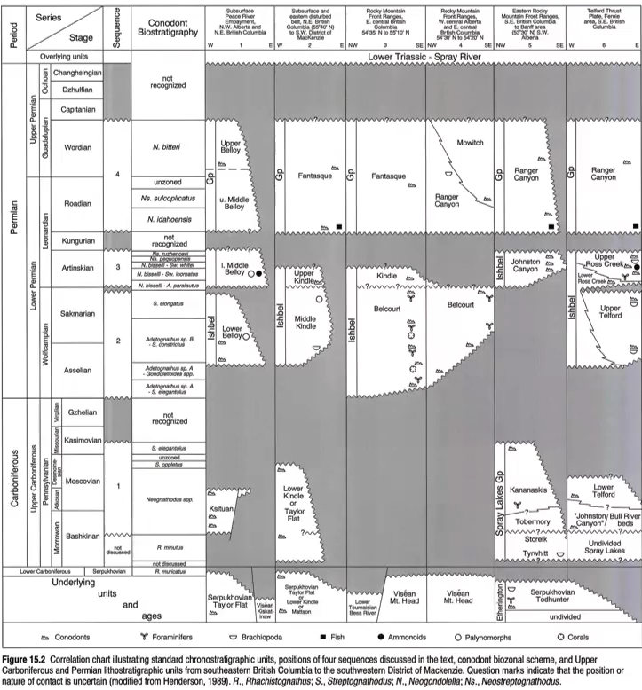
The succession has major unconformities (i.e. it is more gaps than record!)
Conodonts are from lamprey-like organisms.
Rocks are named at the location they are discovered and are later on they are correlated.
Beloy → what subsurface rocks are called.
Everything that is horizontally aligned (on the image) would be age equivalent. However, the names are different because of the locations.

Depositional Environments During the Carboniferous–Permian
Most sedimentation represents sallow marine conditions, with some deeper marine rocks, and one distinctive continental unit.
Sediment types (fewer carbonates) were controlled by northward shift of craton, to perhaps 45 degrees N Lat by end Permian.
Antler orogeny = island arcs begin to form.
Subdction occurring.
This begins to build BC.
We begin to see a change in climate; climate plays a role in where deposits are formed.
Tropical transitioned into temperate into cooler (with not much rain).
As we transition into the Permian, the carbonates begin to decrease. There is a clastic shift.
As the creatures that make up carbonates prefer warmer weather.
Most Carboniferous and Permian deposits in the Western Canada Sedimentary Basin formed in shallow marine environments.
Shallow marine environments occupied continental shelves and broad coastal regions adjacent to the open ocean.
Water depths were generally low enough for wave activity to influence sediment deposition.
Marine conditions dominated much of the basin throughout this interval.
Small portions of the basin occasionally experienced deeper marine deposition.
These deeper-water deposits accumulated farther from shore where energy levels were lower.
Continental deposits were relatively uncommon but are important because they provide evidence for terrestrial environments.
The combination of marine, deep marine, and rare terrestrial deposits demonstrates that depositional environments varied considerably across the basin.
Structural lows such as the Peace River Embayment and Ishbel Trough preserved much of the sedimentary record because they remained submerged for longer periods.

Pangaea and Global Paleogeography
During the Carboniferous and Permian, Earth's continents were assembled into the supercontinent Pangaea.
Pangaea formed through continental collisions associated with the Wilson Cycle.
The Wilson Cycle describes the repeated opening and closing of ocean basins through plate tectonic processes.
Earlier in Earth's history, the supercontinent Rodinia existed before eventually breaking apart.
Pangaea represents a later stage of continental assembly.
Nearly all major landmasses were joined into a single enormous continent.
North America occupied the northwestern portion of Pangaea.
South America was attached to Africa.
Antarctica, Australia, and India were connected to the southern portion of the supercontinent.
China existed as a separate continental block near the Paleotethys Ocean.
As Pangea went northward from Carboniferous to Permian, the ice started to melt as the south migrated towards the equator.
Caused sea level to rise.
There was also a global shift to arid conditions as Pangea was being formed (complete in Early Triassic).
The rain cycle and ocean cycle shifted as a result of the large landmass.
The arrangement of continents significantly altered global climate patterns, ocean circulation, and sedimentation.
The enormous size of Pangaea influenced atmospheric circulation and rainfall distribution across the globe.
Continental interiors became increasingly dry because moisture from oceans could not easily penetrate far inland.
These changes played a major role in the environmental shifts observed during the Permian.
Northward Migration of Pangaea
During the Carboniferous, portions of Pangaea extended into high southern latitudes.
Large regions of the southern supercontinent were covered by glaciers and ice sheets.
Significant volumes of water were stored as ice near the South Pole.
Over time, Pangaea migrated northward due to plate tectonic motion.
As the supercontinent moved toward lower latitudes, climatic conditions became warmer.
Glaciers and ice sheets began melting.
Melting ice released enormous volumes of water into the oceans.
Rising sea levels flooded continental margins and increased marine deposition.
Many researchers propose that this melting contributed significantly to the sea-level rise observed during the Absaroka Sequence.
Global climate changes associated with this migration affected ecosystems, sedimentation patterns, and ocean chemistry.
North America gradually shifted from tropical conditions toward more temperate and eventually more arid environments.
Climate Change During the Permian
One of the most important themes of the Permian is large-scale climatic change.
Earlier Paleozoic deposits often formed under warm tropical conditions favorable for carbonate production.
As Pangaea migrated northward, climate patterns changed dramatically.
Atmospheric circulation systems were reorganized because of the immense size of the supercontinent.
Ocean currents were altered as continental positions changed.
Rainfall patterns shifted across large regions of the globe.
Many areas experienced decreasing precipitation and increasing aridity.
Extensive desert environments developed across portions of Pangaea.
Regions that had previously supported abundant carbonate-producing organisms became less favorable for carbonate formation.
The climate transitioned from humid conditions toward increasingly dry conditions.
Evidence suggests that Alberta experienced a shift toward arid and semi-arid environments during the Permian.
Seasonal rainfall became less predictable.
Flash flooding became more common due to infrequent but intense precipitation events.
Vegetation cover decreased in many areas.
Reduced vegetation allowed erosion rates to increase because plant roots no longer stabilized sediments.
Greater sediment supply contributed to increased siliciclastic deposition throughout the basin.
Permian:
Earliest flies, moths, beetles and wasps.
First vertebrate herbivores.
Conifers take over.
Supercontinent Pangea takes shape.
Climatic shift from humid icehouse to dry greenhouse as Pangea moves north.
Amphibians lose ground, synapsids and diapsids develop,

Permian Depositional Analogue: Baja California
Geologists often use modern environments to interpret ancient depositional systems.
The Permian environment of western Canada is frequently compared to modern Baja California.
Baja California is characterized by arid climatic conditions.
Evaporation rates are high relative to precipitation.
Coastal environments include tidal flats, tidal channels, ephemeral streams, and salt flats.
Ephermeral rivers → rivers that don’t always have flow at all times of the year (as rainfall is irregular).
Sometimes, the rainfall can be quite heavy. Heavy rainfall → runs to the coast → forms rivers → rain stops → rivers dry up.
Similar conditions are believed to have existed in western Canada during portions of the Permian.
Tidal flats formed where seawater periodically flooded low-lying coastal regions.
Repeated flooding and evaporation produced extensive mudflat deposits.
Tidal channels transported water during incoming and outgoing tides.
Salt flats formed where seawater evaporated and left behind dissolved minerals.
Coastal sedimentation was strongly influenced by alternating wet and dry conditions.
These environments provide valuable modern analogues for interpreting Permian rocks.
Ephemeral Rivers
Ephemeral rivers are streams that do not flow continuously throughout the year.
Water is present only after rainfall events.
During dry periods, river channels may contain little or no flowing water.
Arid climates often promote development of ephemeral drainage systems.
Rainfall occurs infrequently but can be extremely intense.
Sparse vegetation allows rapid runoff following storms.
Large volumes of water flow quickly through existing channels.
Once rainfall ends, channels may dry completely.
Repeated floods reuse the same low-lying pathways across the landscape.
Sediments deposited by ephemeral rivers can preserve evidence of periodic flooding.
Such systems were likely important components of Permian landscapes in western Canada.
Transition from Carbonate to Siliciclastic Deposition
There was a shift in sedimentation to siliciclastics.
Our deposits are sediments largely eroded from the coast.
Earlier Paleozoic successions were dominated by carbonate deposition.
Carbonate rocks form primarily through biological activity of marine organisms.
Many carbonate-producing organisms require warm, shallow, tropical marine conditions.
Modern analogues include environments such as the Bahamas and portions of Australia.
As climate conditions changed, these favorable environments became less common.
Carbonate-producing organisms declined in abundance.
Carbonate deposition decreased substantially during the Permian.
Siliciclastic sedimentation became increasingly dominant.
Siliciclastic sediments originate from erosion of continental rocks.
Increased aridity promoted physical weathering and erosion.
Reduced vegetation allowed sediments to be transported more easily into the basin.
Rivers and coastal processes carried large volumes of sand, silt, and mud into marine environments.
As a result, sandstone, siltstone, shale, and conglomerate became increasingly important components of the sedimentary record.
This shift from carbonate to siliciclastic deposition represents one of the defining characteristics of the Permian succession.
Less dolomitic carbonates.
As a consequence of having less limestone deposited.
Isolated little patches that critters would live in (as we shift northward).
There was a shift in sedimentation to siliciclastic, with lesser dolomitic carbonates, and appearance of abundant chert (form of SiO2) especially in Lower Permian Belloy Formation.
End Permian specifically.
As we shift from the Permian to the Mesozoic, there is more cycloclastics, less carbonates, and more chert.
Chert:
Concoidally fractures → does not break in a simple straight line.
Used to be used in the past for spears, etc. Jagged cuts due to the microcrystalline.
Very resistant to weathering; strong material.
Sometimes isn’t continuous. It can be in isolated pockets.
Phosphate:
Phosphate deposits also exist. Organisms need phosphate to function.
Incorporated in whatever biota is living there at the time.
When animals die, the phosphate is dissolved in the water, released, and back into the cycle. However, dissolution of phosphate is temperature dependent.
Easier to dissolve when its hotter water.
For us, we are in the zone where phosphate would precipitate.
Looks like black pebbles.
Phosphate also incorporates other elements into it, such as thorium and uranium.
The rocks will give off a small amount of radiation.
The radiation measured from potassium, uranium, and thorium is measured and weighed based on a known formula.
Gamma ray spike with the phosphates at the boundary.
These elements are also incorporated into things like mudstones because of clay.
Clays like sticking things to themselves.
Less radioactive elements are found in sandstone.
The chert/chert pebble horizon is a classic marker or pick for top of Paleozoic.
Biological Changes During the Carboniferous–Permian
Significant biological evolution occurred during the Carboniferous and Permian.
Insects diversified considerably during this interval.
Early representatives of flies, beetles, moths, and wasps appeared.
Terrestrial ecosystems became increasingly complex.
Vertebrate herbivores became more abundant.
Plant communities underwent substantial evolutionary change.
Early conifers appeared and became increasingly important components of terrestrial ecosystems.
Conifers reproduce using cones and are ancestors of many modern gymnosperms.
Amphibians remained important but gradually declined in dominance.
Synapsids and diapsids became increasingly successful.
These groups are distinguished by the number and arrangement of openings within their skulls.
Synapsids eventually gave rise to mammals.
Diapsids eventually gave rise to dinosaurs, birds, and many modern reptiles.
The Permian therefore represents a critical period in vertebrate evolution.
Many evolutionary lineages that later dominated the Mesozoic originated during this interval.
Environmental Consequences of Climate Change
Climatic shifts affected both terrestrial and marine ecosystems.
Decreasing rainfall altered vegetation patterns across large regions.
Carbonate-producing organisms declined because environmental conditions became less favorable.
Increased erosion supplied larger volumes of siliciclastic sediment to marine basins.
Desert environments expanded across portions of Pangaea.
Aridity increased throughout many continental interiors.
Coastal systems became dominated by tidal flats, ephemeral streams, and siliciclastic sedimentation.
Environmental changes occurring during the Permian set the stage for many of the major geological and biological events that followed.
These changes culminated in the profound environmental disruptions associated with the end-Permian mass extinction.
Sedimentary Formations and Rock Types
The Carboniferous and Permian successions contain a variety of sedimentary rock types that reflect changing environmental conditions.
Deposits include sandstone, conglomerate, shale, siltstone, limestone, dolostone, mudstone, and chert.
The overall trend through time is a gradual decrease in carbonate deposition and an increase in siliciclastic deposition.
This transition reflects both climatic change and changing basin conditions.
Tunnel Mountain Formation
The Tunnel Mountain Formation is a Pennsylvanian (Carboniferous) deposit exposed in the Rocky Mountains.
It consists primarily of quartz arenite.
Quartz arenite is an extremely mature sandstone composed almost entirely of quartz grains.
The high quartz content indicates extensive weathering and transport prior to deposition.
These deposits are interpreted as high-energy coastal or beach environments.
Quartz-rich sands accumulated where wave and current activity removed less resistant minerals.
The resulting sandstone is exceptionally clean and well sorted.
Ishbel Group
The Ishbel Group contains important Permian deposits preserved throughout parts of the basin.
Mudstones are common within portions of the Ishbel succession.
Many mudstones contain carbonate cement that formed after burial.
Carbonate cementation is a diagenetic process, meaning it occurs after sediment deposition.
Sediments were originally deposited as unconsolidated mud.
During burial, mineral-rich fluids migrated through pore spaces.
Calcium carbonate precipitated from these fluids and filled pore spaces between grains.
This process transformed soft sediment into lithified sedimentary rock.
Carbonate cementation commonly increases rock strength and resistance to weathering.
The Ishbel Group also records the increasing dominance of siliciclastic sedimentation during the Permian.
Decline of Dolomite Formation
Dolomite formation became less common during the Permian.
Dolomite generally forms when magnesium-rich fluids alter pre-existing limestone.
This process usually occurs after deposition during diagenesis.
Magnesium replaces some calcium within the original carbonate minerals.
Because less limestone was being deposited during the Permian, less material was available for conversion into dolomite.
The decline in carbonate production therefore indirectly reduced dolomite formation.
This trend reflects the broader environmental shift occurring throughout the basin.
Kananaskis Formation Bioherms
The Kananaskis Formation contains localized carbonate buildups known as bioherms.
Bioherms are mound-shaped accumulations formed by biological activity.
Unlike large reef complexes, these bioherms were relatively isolated features.
Algae were important contributors to bioherm construction.
Algal communities trapped and bound sediment as they grew upward.
Continuous growth produced elevated carbonate mounds on the seafloor.
Sediment transported by currents became incorporated into the growing structure.
These bioherms represent some of the last significant carbonate-producing ecosystems before siliciclastic deposition became dominant.
Their occurrence indicates that suitable carbonate-producing environments still existed locally despite broader environmental changes.
Expansion of Chert Deposition
Chert became increasingly abundant during the Permian.
The Beloy Formation contains particularly important chert accumulations.
Chert deposition reached its greatest development during the late Permian.
Large chert bodies accumulated within deeper portions of the basin, especially within the Ishbel (Prophet) Trough.
Chert became one of the defining lithologies of the upper Permian succession.
Increasing chert abundance is a key indicator of changing depositional conditions near the end of the Paleozoic.
The transition from carbonate-rich deposits to chert-rich deposits reflects significant environmental reorganization.
Characteristics of Chert
Chert can occur in a wide range of colours including black, dark gray, light gray, brown, red, and purple.
Colour differences reflect variations in impurities and depositional conditions.
Chert possesses exceptional hardness due to its silica-rich composition.
It is highly resistant to both chemical weathering and physical erosion.
Chert commonly forms prominent ridges because surrounding rocks erode more easily.
The rock exhibits conchoidal fracture, producing smooth curved breakage surfaces.
Fractured surfaces often resemble the inside of a shell.
This fracture pattern allows extremely sharp edges to form.
Ancient peoples frequently used chert for tools, weapons, and cutting implements.
Arrowheads, spear points, scrapers, and knives were commonly manufactured from chert.
The microcrystalline texture contributes to its sharpness and durability.
Permian–Triassic Boundary
The Permian–Triassic boundary marks one of the most important intervals in Earth history.
This boundary separates the Paleozoic Era from the Mesozoic Era.
It also corresponds to the largest mass extinction event known from the geologic record.
In the Rocky Mountains, the boundary is commonly marked by distinctive lithologic changes.
Resistant Permian chert deposits often underlie softer Triassic sedimentary rocks.
Differential erosion causes the boundary to be expressed prominently in the landscape.
Rivers frequently follow the contact because softer Triassic rocks erode more readily than underlying chert-rich Permian units.
Numerous exposures occur in Banff, Jasper, Nordegg, and surrounding mountain regions.
The contact is therefore both stratigraphically and geomorphologically significant.
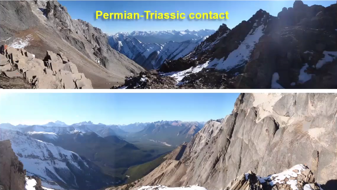
Permian–Triassic Exposures in Banff
Excellent exposures occur near Banff along river valleys and waterfalls.
Permian rocks consist largely of resistant chert-rich deposits.
Overlying Triassic deposits consist mainly of fine-grained sandstones and siltstones.
The Triassic rocks weather and erode much more easily than the underlying chert.
This contrast produces steep slopes and prominent landscape features.
Water preferentially erodes the weaker Triassic rocks while resistant Permian rocks remain exposed.
The resulting outcrops provide clear evidence of the transition between geological eras.
The Pennsylvanian Storelk Formation is a sandstone with large scale, high angle cross beds that are aeolian in origin (93m thick at type section).
Some terrestrial deposits in the Storelk formation.
Fossils:
Coal deposits derived from accumulation of woody plant matter in coastal swamp settings, such as are not recorded in the WCSB.
A lot of the coal deposits are from the Carboniferous.
Chert Ridges and Mountain Landscapes
Chert-rich Permian units commonly form resistant ridges throughout the Rocky Mountains.
Many mountain outcrops expose thick accumulations of late Permian chert.
Original deposition occurred in horizontal layers on the seafloor.
Subsequent mountain building deformed these strata.
Compression associated with Rocky Mountain formation tilted, folded, and uplifted the deposits.
Layers that were once horizontal now commonly appear vertical or steeply inclined.
These exposures provide valuable insight into both depositional and tectonic history.
Resistant chert often remains visible long after surrounding rocks have been removed by erosion.
Conglomerates
Conglomerates occur locally within Permian successions.
Conglomerates consist of rounded gravel-sized clasts cemented together.
Clasts may range from pebbles to cobbles and larger fragments.
High-energy environments are required to transport and deposit such coarse material.
Rivers, beaches, and alluvial systems commonly produce conglomerates.
Their presence indicates periods of increased sediment transport and energetic depositional conditions.
Conglomerates provide evidence for nearby sediment sources and active erosion.
Red Triassic Rocks
Triassic rocks within the Rocky Mountains commonly display reddish colours.
Red coloration typically results from oxidation of iron-bearing minerals.
These rocks contrast strongly with darker Permian chert deposits.
The colour difference often makes the Permian–Triassic boundary easy to identify in the field.
Isolated remnants of Triassic strata may survive on mountaintops where erosion has not completely removed them.
These preserved remnants provide valuable records of early Mesozoic environments.

Importance of the Permian–Triassic Boundary
The Permian–Triassic boundary represents a major turning point in Earth history.
Where the biggest mass extinction is recognized. Most life died off.
Early mammals, icthyosaurs (early dolphins), and early dinosaurs begin to form.
It marks the transition from Paleozoic ecosystems to Mesozoic ecosystems.
Significant changes occurred in climate, ocean chemistry, sedimentation, and biological communities.
The boundary records both geological and biological upheaval on a global scale.
Western Canadian exposures provide important evidence for studying these worldwide changes.
Chert-rich Permian deposits immediately beneath the boundary serve as important markers for regional correlation.
End-Permian Mass Extinction:
A combination of factors likely led to this extinction.
One of the factors: methane clatherates; methane can freeze.
As Pangea migrated northward, many clatherates melted → methane released into the atmosphere → atmosphere composition changed.
Coal seams were also previously deposited. There’s some evidence pointing to coal seams lighting on fire → CO2 released into the atmpshere.
Siberian traps: a huge eruption of flood basalts.
Lava erupting and spreading everywhere.
It covered a huge area, 25m thick.

Volcanic Eruptions (and how it affects climate):
Thermogenic gas emissions. Hot gases are released.
CO2, SO2, chlorine, fluorine, and NOx.
Concentrate heat into the atmosphere and cause acid rain.
These change the acidity of the oceans.
Also makes clacium carbonate dissolves.
Ash and particulates are deposited into the atmosphere → a huge cloud forms that can block the sun.
Can cause global cooling.
Plant life will struggle → photosynthetic shutdown.
Everything that eats the plants? dies.
The soil can easily be washed away (erosion) without plants. The soil gets dumped into the ocean.
Algae begins to bloom once soil is dumped into the ocean. They begin to use up all the oxygen in the ocean, causing ocean anoxia.
End-Cretacous was a meteor.


ANS: True