lecture 1: ocean basins
how scientists map and characterise seafloor features
how do we know what the ocean floor looks like?
what types of geographic features would you expect to find there?
the ocean floor is mapped by bathymetry
bathymetry → the discovery and study of the ocean floor topography
ancient methods: early depth measurements used weighted ropes or poles
18th to 19th century: systematic lead line soundings by naval expeditions (e.g. HMS challenger, 1872-76)
early 20th century: introduction of echo sounding (sonar) for faster, more accurate depth measurement
mid 20th century: development of multibeam sonar systems for wide-area seabed mapping
1970s - 1980s: use of satellite altimetry to infer seafloor topography over large scales
ongoing efforts: projects like seabed 2030 aim to map the entire ocean floor by 2030
echo sounding
simple depth sounder
2 seconds for a sound pulse to strike the bottom and return to the ship when water depth is 1500 meters
basic depth sounders lacked teh resolution and were unable to provide detailed iamges of the ocean floor
multibeam sonar
multibeam echo sounders work by bouncing sound off the seafloor, like other echo sounders
use up to 121 beams radiating from the ship’s hull
fan out at right angles to the direction of travel
a ping is sent every 10 seconds toward the seabed, the reflected sound is recorded from narrow corridors
provide more accurate data than single-beam systems and are less prone to errors due to more focused coverage
satellites
satellites measure small variations in the elevation of surface water
because of their precise position, the average height of the ocean surface can be known with great accuracy
geosat, TOPEX/Poseidon, Jason-1, and Jason-2 allowed rapid, alrge.scale seaflor mapping
they revealed several underwater features and provided crucial data for understanding global seafloor topography
features of earth’s solid surface
the ocean makes up 70.8% of the earth’s surface, and the rest 29.2% is land
within the 70.8%,
22.1% is oceanic ridges
29.8% is the ocean basin floors
3.7% are volcanic island arcs, trenches, submarine volcanoes, and hills
3.8% is continental rise
of the 29.2% of land,
10.3% are mountains
18.9% are continental lowlands
11.4% are continental shelves and slopes
ocean floor topography varies with location
earth’s surface is a dynamic mosaic of moving lithospheric plates
seabed topography results from plate movement and isostatic balance
continental crust → thicker and less dense (granite)
oceanic crust → thinner and denser (basalt)
isostatic equilibrium explains differences in eelvation between alnd and seabed
high density of oceanic lithosphere keeps most of the seafloor >3000 meters deep
transition to basalt marks the edge of a continent
divides the ocean floor into two main provinces
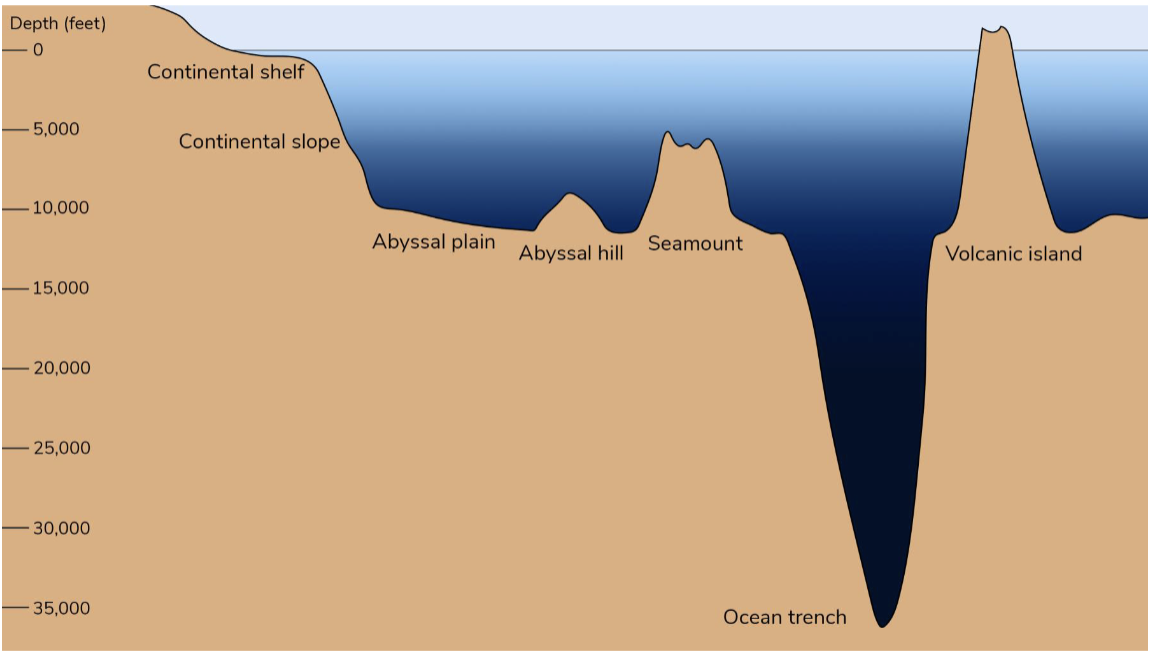
continental margin → the submerged outer edge of a continent
ocean basin → the deep sea floor beyond the margin
the shallow submerged extension of a continent is called the continental shelf
characteristic features of continental margins and how those features may vary in different locations
Continental margins can be active or passive
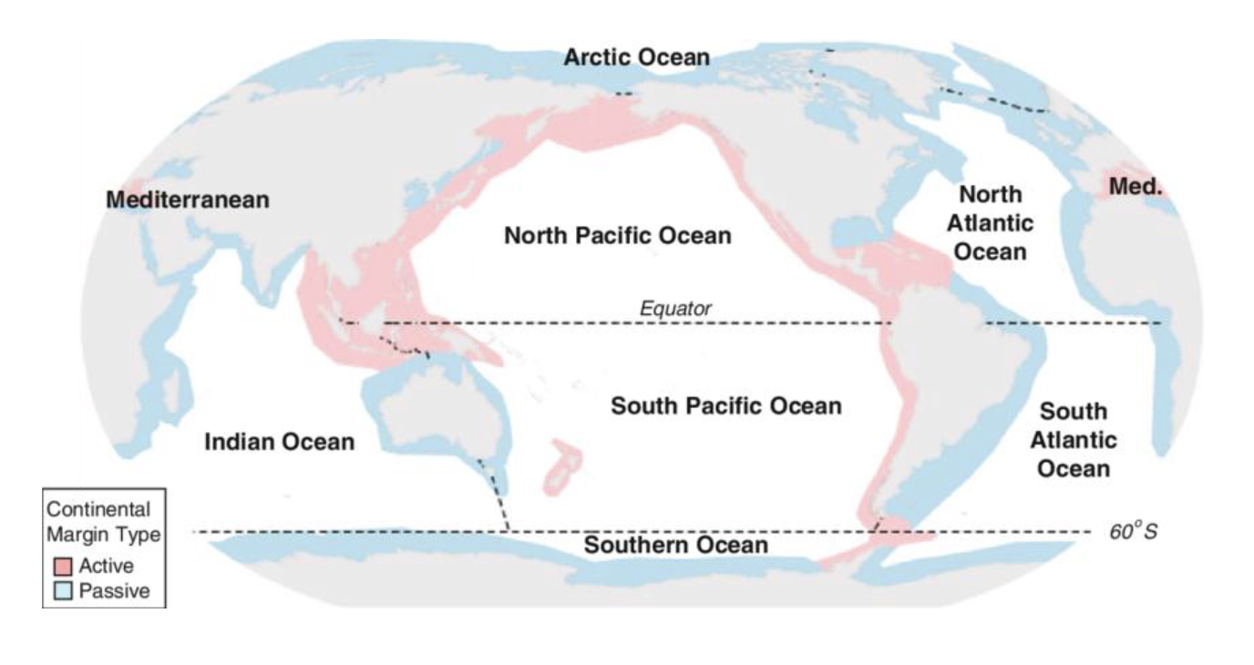
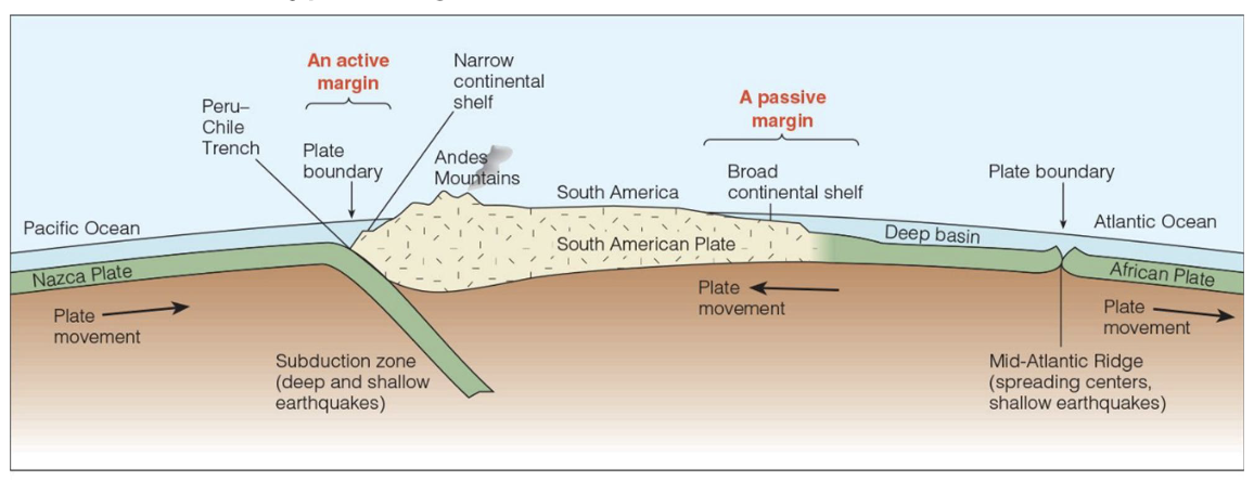
active continental margin → a geologically active coastline located at a tectonic plate boundary characterised by frequent earthquakes, volcanic activity, mountain building, and a narrow continental shelf that slopes abruptly into a deep ocean trench due to subduction
passive continental margin → a geologically stable region marking the transition from thick continental crust to thinner oceanic crust, formed by continental rifting and subsequent seafloor spreading, and not by an active plate boundary
characteristic features of continental margins
passive margins →
forms where plates are moving apart (diverging boundaries)
characterised by broad continental shelves, thick sediments, and gentle slopes
little tectonic activity (earthquakes and volcanic)
common around the Atlantic ocean - called atlantic-type margins
active margins →
forms where plates collide (converging) or slide past one another (transform boundaries)
narrow shelves, steep slopes, deep ocena trenches often present high tectonic activity (earthquakes and volcanic)
common around the pacific ocean - called pacific type margins
features of a passive continental margin (Atlantic type)
broad gently sloping shelf extends far form shore
extends from shore in a gentle slope
350 km in width and end at a depth of about 140 m, where a steeper drop-off begins
continental slopes connect the continental shelves to the deep-ocean floor
the continental slope is the transition between teh continental shelf and the deep ocean floor
continental slopes are formed by sediments accumulating at the shelf edge
sediments are transported downslope to the ocean floor
continental rises form as sediments accumulate at hte base of the continental slope
sediments that form the continental rise are trasnported by turbidity currents
earthquakes can trigger underwater landslides or sediment flows. These fast-moving flows are called turbidity currents (27 km/h)
the topography of deep ocean basins differs from the continental margin
the seafloor is a blanket of sediment up to 5 km thick covering basaltic rocks
deep-ocean basins constitute more than half of earth’s surface
the sediments on the deep ocean floor reflect the history of the surrounding continents, the biological productivity, and the ages of the basins
origin, characteristics, and features of oceanic ridges
continuous ridge of underwater mountains in the deep ocean (>1500m)
the mid ocean ridge is technically the longest mountain range on earth
they occur along divergent plate boundaries, where new ocean floor is created as the earth’s tectonic plates spread apart
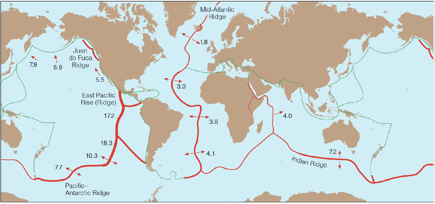
the thickness of the red lines indicates the rate of spreading and the numbers indicate the spreading rates in cm/year
spreading rates controls the topography
as the plates separate, molten rock rises to the seafloor, producing enomous volcanic eruptions of basalt
spreading speed shapes the ridge:
slow spreading → steep, rugged terrain (rift valley); e.g. mid-Atlantic ridge - rate of 2 to 5 cm per year
fast spreading → wide gentle slopes; e.g. East Pacific Rise - rate of 6 to 16 cm per year
cross section of mid ocean ridge
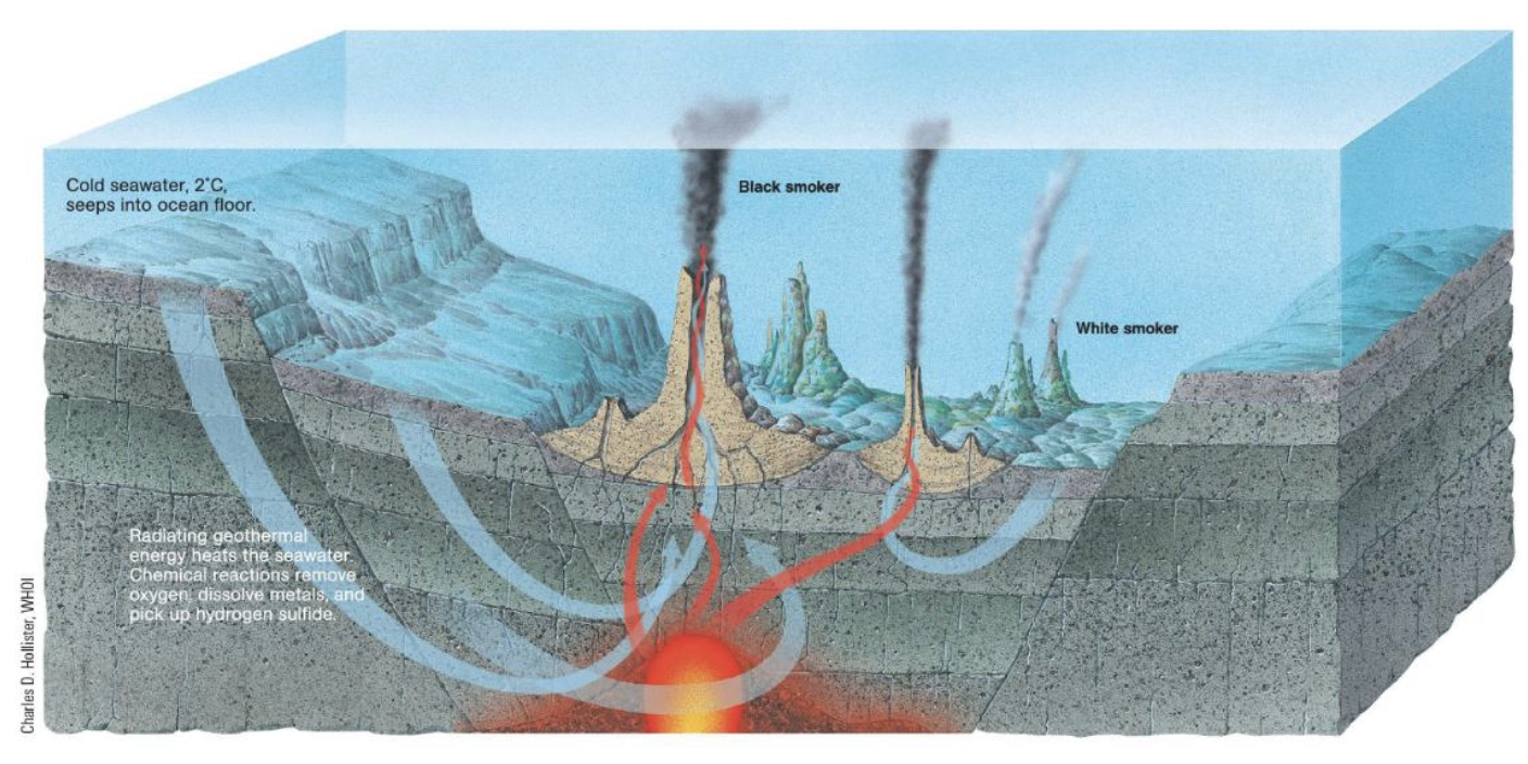
hydrothermal vents are hot springs on active ocean ridges
major features of ocean basins: abyssal plains and trench
abyssal plains (and abyssal hills) cover most of earth’s surface
abyssal plains → they are flat featureless expanses of sediment covering the ocean floor
they lie between the continental margins and the oceanic ridges
the Canary Abyssal Plain (west of the Canary Islands in the north atlantic) has an area of about 900,000 square kilometers
seamounts and oceanic trenches
Seamounts → volcaninc projections that do not rise above the surface of the sea
trench → is an arc shaped depression in the deep ocean floor. They occur where a converging oceanic plate is subducted
Mariana Trench
Mariana Trench Marine National Monument consists of 246,608 square kilomoeters of submerged lands and waters of the Mariana Archipelago east of the Phillipines
trenches and trash
the mariana trench is the deepest spot on our earth. Do you think humans have had an environmental impact on this location? what types of impacts do you think are present?
plastic trash has been found in the bottom, nad mercury pollution has been found within the area
how would scientists be able to explore and detect if humans have impacted this region?
scientists found it by looking through the deep sea debris database
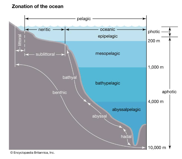
the various zones that the marine environment is genenrally divided into
major features of ocean basins
the marine environment is calssified in distinct areas based on physical features
these zones or areas are based on light, temperature, salinty, depth, latitude, water density, or almost any of the other physical dimensions
pelagic (open water zones):
neritic zone → shallow water over the continental shelf
oceanic zone → deep water beyond the shelf (92% of total marine area and 65% of earth’s surface)
epipelagic: sunlit surface layer (photic zone)
mesopelagic, bathypelagic, abyssopelagic: deeper darker layers
abyssopelagic: water in deep ocean trenches
benthic (ocean bottom) zones:
littoral zone: shoreline area affected by tides
sublittoral zone: seafloor near shore and out to the shelf edge
bathyal zone: slope regions leading to deep sea
abyssal zone: deep ocean floor
hadal zone: deepest trenches and trench walls
neritic x oceanic zones: nutrients
as you get closer to Antarctica, the concentration of nutrients increases
as you get closer to the equator form the south pole, you’ll notice that the nutrients decrease in amount
there are high amounts of silicate present in the bottom close to the antarctic