1.4 drainage basin system
Define the following key words:
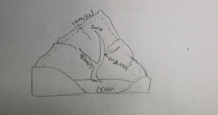
Drainage Basin
The area of land that is drained by a river and its tributaries
Watershed
The boundary around the edge of a river basin
Tributary
A smaller stream that flows into a larger river
Source
Where the water for a river is originating from, often a spring in the mountains
Confluence
The area where a tributary joins onto the main river
Add your annotated sketch here
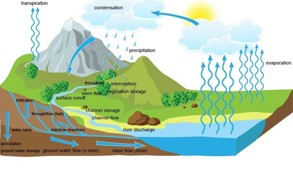
Write a short paragraph describing the route water can take when a drainage basin experiences precipitation.
Water can flow from the source through the river to the large body of water at the bottom where it can then be evaporated, then precipitated on the ground, where it may get intercepted by trees, where it can then move as stem flow into the ground where it can infiltrate. Some will then be absorbed by the plant and carry on as evapotranspiration, but some of the remaining water will move as throughflow, some will percolate deeper as groundwater flow, and the rest will be infiltrated deeper and will end up as baseflow.
Draw a diagram showing all these as a flow diagram.
Can you explain what would happen if an area was:
Heavily deforested.
The trees would not contribute via stem flow, interception or evapotranspiration so there would be more water going into the soil creating a surplus which can cause grater soil erosion, which increases carbon release which increases precipitation - positive feedback loop - greater flood risk
Change grassland to woodland.
The water would be slower to reach the ground so there would be less water in the soil at any one time due to increased interception, which will decrease erosion and surface runoff. There would also be greater evapotranspiration due to the trees absorbing more water through the roots once it has infiltrated.
Change grassland to crops.
There would be a greater rate if evapotranspiration so the water in the soil would get used up faster. The breaking up if the soil when planting the crops would increase infiltration and therefore also increase soil erosion. When the crops are harvested there is nothing harvested which means that more water is infiltrating when there is rain and therefore there is greater surface runoff and greater chance of flooding
Urbanize an area.
There would be less infiltration, throughflow, groundwater flow and base flow which will increase surface runoff as there will be less capacity to hold water in the soil and therefore the risk of flooding is much greater also due to the fact that there will be less trees reducing absorption and evapotranspiration.
How would the flow vary according to different geological characteristics.
If the bedrock was made up of chalk, it can absorb water and allow water to move through it, where granite would not allow any water to pass through as it is very impermeable