GEOGRAPHY
NOTES
1 - Introduction to Year 8 Geography - Notes: N/A
2 - Landforms vs Landscapes
Notes: Landform: an individual surface feature of the Earth identified by its shape Landscape: a large area that has evolved.
A landscape is part of the Earth’s surface. It consists of a variety of geographical features that are characteristic of an area. Landscapes are divided into two main categories – natural and human. Natural landscapes (for example, mountains and deserts) are mainly unaffected by human activity and typical to particular world areas.
Human landscapes (for example, cities and farms) have been created and modified by people. Human landscapes are sometimes also referred to as cultural landscapes.
Some different types of landscapes are described below.
Types of landscapes: A variety of landforms contribute to the overall landscape of an area. So within a landscape, there can be many landforms. Earth has a vast range of landscapes, including icy polar regions, mountain ranges, vast arid deserts, islands and coastal landscapes, woodlands, tropical rainforests, and agriculture/farmland.

8 main landscapes:
Rainforest: A forest with many tall trees and high levels of rainfall
Mountain: An area that rises above its surroundings by at least 300m. It has steep slopes and is recognised as a raised section of the Earth's crust.
Desert: An area that has low levels of rainfall (At most 25 cm per year).
Coastal: Where the land slopes into the ocean and leaves deposited sediment (usually sand or mud) on the coast.
Grassland: An area covered in vegetation. These landscapes are filled with grass and are often used for grazing.
Savanna: A grassland plain with few trees, located in subtropical and tropical regions.
Tundra: An area with limited tree growth due to cold temperatures and frozen subsoil.
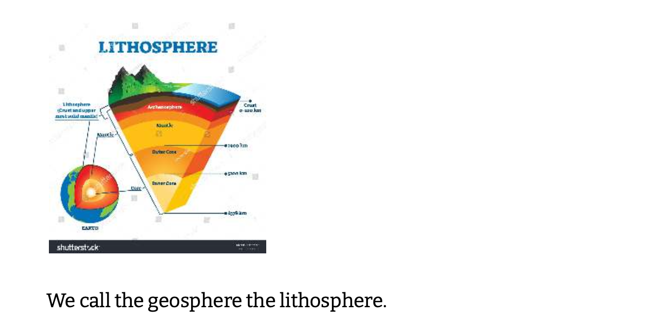
Polar: An area located in the north/south pole with freezing temperatures, forming features such as icebergs. We call the geosphere the lithosphere.
Landforms: Defining characteristics
Mountain: A large hill that has sides much steeper than the surrounding surface.
Plateau: A large area of high land that is relatively flat on its top. Mesa: A medium-sied pateau.
Butte: A small-sized plateau.
Volcano: A mountain with lava.
Desert: A large area that loses more water than it gains.
Delta: A triangle-shaped piece of land that forms at the mouth of a river
Island: A piece of land surrounded by water on all sides. A desert is not a ‘landform’ but a landscape.
3 - Different landforms
Notes: Landscapes: Landforms within each landscape Mountains:
Canyon, valleys, hills, plateau, volcano
Rainforests: Meander, valleys, hills, wetlands, floodplain
Savanna/grasslands: Plains, waterhole, hills
Deserts: Alluvial fans, dunes, playas, arroyos, oasis, buttes
Coastal: Beach, headland, stacks, tombolo, karst, caves
The term landform is a narrow geographic term used to identify the shape (or morphology) and character of a land surface. Landforms are a subset of the natural or physical landscapes of the world.
4 - Plate tectonics
Cross-section: When we look through an object by cutting it in half, we call this a cross-section. It lets us see the shape of the object from a different angle.
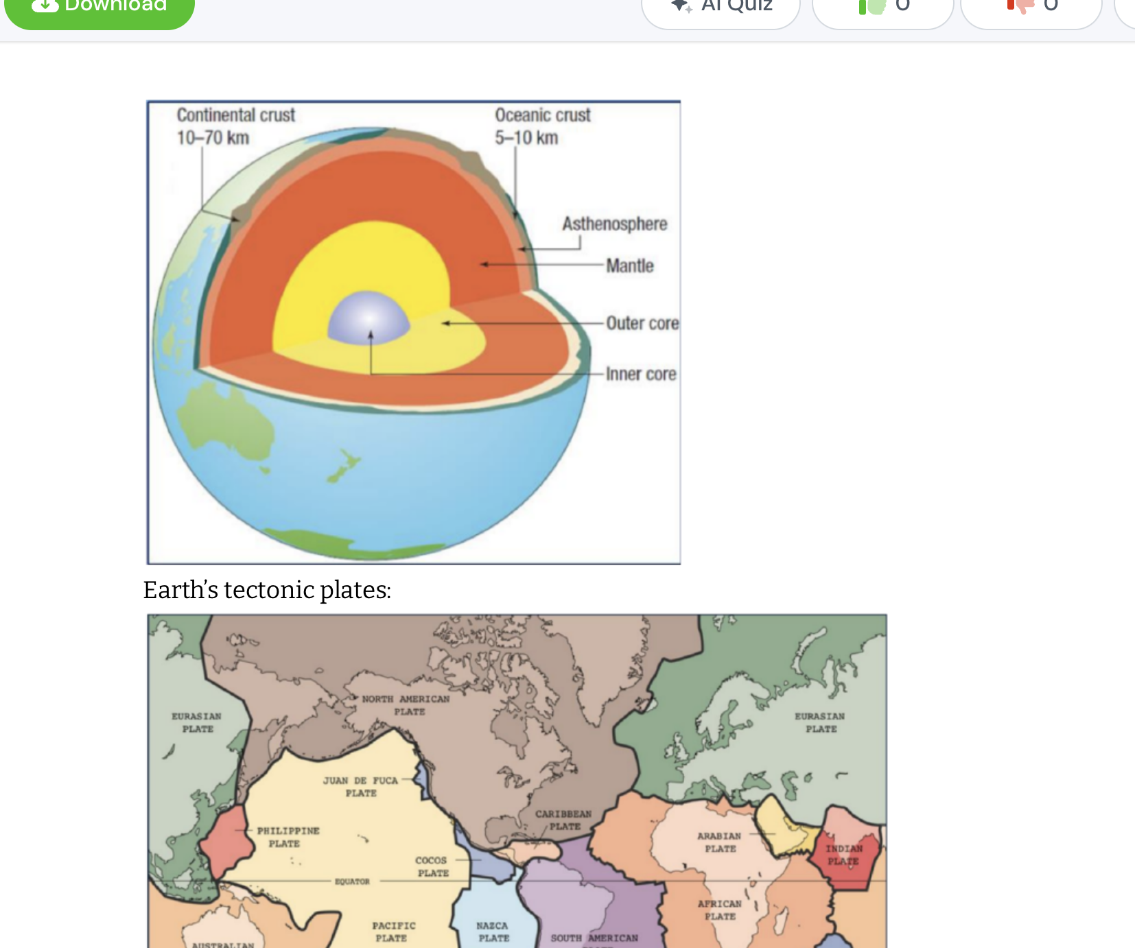
Geomorphic Processes: The main processes that change landscapes are called geomorphic processes. These occur because the Earth is made up of four main layers – the crust, the mantle, an outer core and an inner core.
The Earth’s crust, where we live, floats on a thin molten layer called the asthenosphere.
The crust is then broken up into several pieces we call tectonic plates. These plates are always moving over the molten asthenosphere.
So the land we are standing (or sitting) on now is slowly moving. The plates move because of large heat currents in the mantle. We notice this movement of the tectonic plates when earthquakes occur or volcanoes erupt.
Convection currents: Heat from Earth’s core pushes tectonic plates across the mantle.
There are seven major plates: African, Antarctic, Eurasian, Indo-Australian, North American, Pacific and South American.
It is the heat from Earth’s core that makes the plates move. In this bowl of water, the water that is heated by the flame rises. As it gets further from the flame, it cools and so it sinks again. This is called a convection current. Convection currents heat water. What would this current do to something that was floating on the surface of the water?
The same thing happens in Earth’s crust. The heat from the core rises, inding weak spots at the edge of tectonic plates. This heat then forces the plates apart.
Crust
Asthenosphere -earths crust floats
Mantle
Outer core
Inner core
5- Interconnections
Human Interaction with Water
Uses: Domestic, agricultural, industrial.
Impacts: Pollution, habitat destruction, climate change effects.
Global Connections
Trade and Resources: Water-intensive products (e.g., cotton).
Transboundary Water Issues: Conflicts and cooperation over shared water resources.
Cultural Significance
Religious and Social: Water’s role in cultural practices and traditions.
Globalisation
The world's increasing interconnectedness due to trade, communication, transport, and cultural exchange.
Definition: Globalisation refers to the process by which businesses, technologies, and cultures integrate and interact globally, leading to increased connections and interdependence between countries.
Key Technologies that Enable Globalisation:
a) Internet and telecommunications (faster communication and data exchange).
b) Transportation (e.g., airplanes and shipping containers, which move goods quickly and cheaply).
Trade: The exchange of goods and services globally.
Communication: Advances in technology (e.g., the internet) that connect people.
Transportation: Air travel, shipping, and rail networks making the movement of people and goods faster.
Cultural Exchange: The spread of ideas, customs, and social behavior between countries.
Interconnected Economies
Supply Chains: How products are made from materials sourced globally.
Multinational Corporations: Companies that operate in multiple countries, connecting economies through production and jobs.
Transport and Technology
Advancements in transport and technology have made the world more connected.
Transport: Airplanes, high-speed trains, and shipping have reduced travel time.
Technology: Smartphones and the internet allow instant communication.
Case Study: Global Fashion Industry
Fashion items are designed in one country, made in another, and sold worldwide.
Impacts include environmental pollution from manufacturing and the exploitation of workers in developing countries.
TNCs (Transnational Corporations)
Definition: A transnational corporation (TNC) is a large company that operates in multiple countries, producing and selling goods or services globally.
Examples:
a) Apple
b) McDonald's
c) Toyota
Tourism and Its Links Between Countries
Explanation: Tourism connects countries by promoting the flow of people, culture, and money. Travelers often share cultural experiences, contribute to the local economy, and create jobs, leading to increased international collaboration and understanding.
Advantages and Disadvantages of Tourism:
Advantage: Economic benefits—tourism can boost the economy by creating jobs and generating income for local businesses.
Disadvantage: Environmental impact—over-tourism can lead to pollution, depletion of natural resources, and destruction of ecosystems.
Tourism connects people to different places.
Positive Impacts: Economic growth, employment, cultural exchange.
Negative Impacts: Environmental damage, overcrowding, cultural erosion.
Managing Tourism's Impact
Example (Acropolis, Greece): To manage the large influx of tourists, efforts include limiting visitor numbers, restoring and preserving historical monuments, and creating sustainable tourism practices. These steps help protect the cultural heritage while minimizing environmental damage.
Links Created by Technology
Explanation: Technology has enhanced communication and connections between countries through the internet, social media, and smartphones. It allows businesses to operate globally and people to share information instantly, facilitating trade, knowledge sharing, and international collaboration.
Transportation Technology and Links Between Countries
Explanation: Advances in transportation, such as the development of jet airplanes and high-speed trains, have drastically reduced travel times, making global trade and tourism easier and faster. This has expanded access to new markets and destinations, creating stronger economic ties.
The Multiplier Effect
Explanation: The multiplier effect refers to the indirect economic benefits that result from a primary activity like tourism. For example, money spent by tourists at local businesses circulates in the economy, as those businesses pay wages to workers, who in turn spend their earnings locally, amplifying the economic impact.
Extreme and Adventure Tourism
Difference:
Extreme tourism involves visiting remote or dangerous locations and participating in risky activities, such as mountain climbing or bungee jumping.
Adventure tourism focuses on more accessible but thrilling experiences, such as hiking, scuba diving, or exploring natural landscapes.
6 - Water in the World
1. Water Cycle
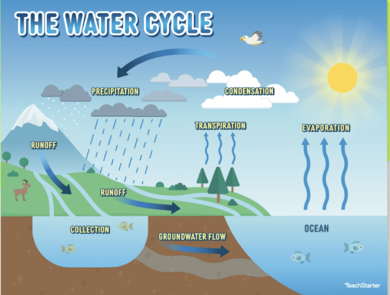
Key Processes: The water cycle includes steps like evaporation (water turns into vapor), condensation (vapor forms clouds), precipitation (rainfall), infiltration (water soaks into the ground), and runoff (water flows over land to rivers and lakes).
Processes:
Evaporation: Water turns into vapor due to heat.
Condensation: Water vapor cools and forms clouds.
Precipitation: Water falls back to Earth as rain, snow, hail or sleet.
Infiltration: Water seeps into the ground.
Runoff: Flows downward until reaching rivers, lakes, or oceans.
These processes are important because they regulate climate, support ecosystems, and provide drinking water.

Types of Water Bodies
Freshwater: Found in Rivers, lakes, groundwater and glaciers. It is only 3% of Earth's water, 2% of it is locked in ice caps or aquifers.
Saltwater: Found in oceans and seas, makes up the remaining 97% of Earth’s water.
Importance of Freshwater: Drinking, agriculture, sanitation.
Importance of Saltwater: Crucial for regulating Earth's climate, supporting marine ecosystems, and providing livelihoods through fishing and tourism.
Importance of Clean Water
Clean water is vital for human health, agriculture, and sanitation. Contaminated water can lead to diseases, reduce crop yields, and negatively impact economies, particularly in developing regions.
.Global Water Distribution
Statistics: 97% saltwater, 3% freshwater (2% is frozen).
Access to Water: Disparities in water access around the world.
Physical Scarcity: Lack of sufficient water resources.
Economic Scarcity: Lack of investment in water infrastructure. Causes include overuse, climate change, pollution, and population growth.
Most of the Earth's water (about 97%) is found in oceans as saline water. Only a small portion (around 3%) is freshwater, much of which is locked in glaciers or ice caps.
Water Management
Issues: Pollution, overuse, water scarcity.
Solutions: Conservation, sustainable practices, technology.
Sustainable Water Use: Methods to manage water resources effectively.
Conservation: Reducing water waste.
Recycling: Treating wastewater for reuse.
Desalination: Turning saltwater into freshwater.
Case Study: Murray-Darling Basin
Australia’s largest river system.
Used for irrigation, but also faces issues with drought and overuse.
Sustainable practices are needed to protect it from long-term damage.
Saline Water
Definition: Saline water is water that contains a high concentration of dissolved salts, making it unsuitable for drinking or agriculture without desalination.
Freshwater Sources in Australia
Examples:
a) Rivers (e.g., Murray River)
b) Groundwater (e.g., Great Artesian Basin)
c) Lakes and reservoirs
Issues with Water Use
Example: Over-extraction of groundwater for agriculture and industry can lead to depletion, causing long-term damage to ecosystems and reduced water availability for future use.
Importance of Clean Water
Clean water is vital for human health, agriculture, and sanitation. Contaminated water can lead to diseases, reduce crop yields, and negatively impact economies, particularly in developing regions.
Threats to Freshwater Supply
1. Climate Change: Changes in rainfall patterns and increased droughts reduce the availability of freshwater.
2. Pollution: Industrial waste, agricultural runoff, and untreated sewage can contaminate freshwater sources, making them unsafe for human use..
7 - Shaping landscapes
While tectonic activity causes the Earth’s surface to be uneven (think of mountains
and volcanoes), gradational forces work to smooth out the landscape. The landforms
and features created by tectonic processes come under attack when they are exposed to atmospheric processes and gravity. Gradational forces wear down the high places and ll in the low places.
The different types of gradational forces are weathering, erosion and deposition. The agents include wind, water, ice, sunlight and chemical decomposition.
Weathering - breakdown/decay not removal
Erosion - Worn down
Deposition - transported e.g. sand example
8 - Boundaries of tectonic plates
Convection currents:
Plate Boundaries: At the boundaries of tectonic plates, landforms are most obviously changing.
Boundaries of tectonic plates:
Divergent Plate Boundaries: Creates like valleys and volcanoes and stu through crust splitting
Oceanic crust splits from oceanic crust - a chain of underwater volcanoes e.g. mid-Atlantic ridge.
Continental crust splits from continental crust - Continental splits forming a valley. e.g. The African Rift Valley.
Convergent Plate Boundaries: Create examples such as mountains, volcanoes, and trenches through crust meet.
Continental crust meets continental crust - Mountains formed by the ‘collision’ e.g. The Himalayas
Oceanic crust meets continental crust -
Oceanic crust sinks back into the mantle, melts and produces volcanoes e.g.the Andies mountains
Oceanic crust meets oceanic crust - Forms a deep trench and a chain of volcanic islands e.g. Indonesia beaches/borders
9. Finding Area Reference, Longitude and Latitude, Compass Directions, and Grid Reference
Area Reference (AR) :
A four-digit number used in maps to indicate a general location within a grid.
Example : AR 3412 refers to the area where grid lines 34 (x-axis) and 12 (y-axis) intersect.
Longitude and Latitude :
Latitude : Horizontal lines that measure distance north or south of the equator (0°). Values range from 0° to 90° N (north) or 90° S (south).
Longitude : Vertical lines that measure distance east or west of the Prime Meridian (0°). Values range from 0° to 180° E (east) or 180° W (west).
Finding a Location : Coordinates are written as (Latitude, Longitude), e.g., Sydney: (-33.8688° S, 151.2093° E).
N and S is latitude while W and E is longitude
Compass Directions :
Cardinal Directions : North (N), South (S), East (E), West (W).
Intercardinal Directions : Northeast (NE), Southeast (SE), Northwest (NW), Southwest (SW).
Using a Compass : The needle always points to magnetic north, and you can use the compass rose for orientation.
Grid Reference (GR) :
A six-digit number that pinpoints a more specific location within a grid square.
How to find i t: The first three digits refer to the eastings (x-axis) and the last three refer to the northings (y-axis).
Example : GR 345123 refers to a precise point along grid line 34 on the x-axis and 12.3 on the y-axis.
