Geography- Unit 1
Introduction to Geography
What is Geography?
Geography is the study of the Earth.
• Word geography comes from the ancient Greek
words geo, meaning “Earth”, and grapho, which
means “I write.”
• Geographers try to understand where things are and why they are there.
Geographers attempt to explain the diverse characteristics of the Earth’s landscape; exploring topics such as population distribution, earth processes (e.g. earthquakes), the atmosphere and oceans, and international issues.
What are the two types of Geography?
Physical Geography
The study of non-human processes
relating to the earth (natural things).
– Examples:Glaciation (glaciers), Tectonism (movement of the earth’s continents), Vegetation patterns,Volcanism (volcanoes), etc.
Human Geography
The study of the distribution and organization of humans, and the human use of resources.
– Examples:e.g. demography, political geography, urbanization, immigration, economic geography
Getting to know Canada
There are 10 provinces in Canada
There are 3 Territories
Canada shares one border which is the U.S.A
the provincial capital of Newfoundland is St. John’s
What is the provincial capital of British Columbia is Victoria
the population of Canada to the nearest million is 38 (in 2021)
Name Canada's longest river:Mackenzie river (Northwest Territories)
two hemispheres where CAnada is located:Northern and Western hemispheres
the largest lake completely within Canada:Great Bear Lake (Northwest Territories)
Canada's largest trading partner is the USA
The city has the largest population in Canada is Toronto
The province that produces the largest quantities of oil and gas is Alberta
province or territory is the highest mountain in Canada -Yukon, Mt Logan (5959 m)
degrees latitude is the Arctic Circle 66.5o North
Name Canada's newest territory: Nunavut (since 1999)
Canadian province has a rainforest is British Columbia
Unit 1: Mapping
Topic 1: Mapping and types of maps
Definition
Map:simplified representation of the earth’s features drawn on a flat surface.
Types of Maps
There are three main types of maps:
General Maps/Road Maps: provide a variety of details such as roads, water bodies, parks, towns
and cities. Give a broad understanding of the location and features of an area
Thematic Maps: provide information about one particular detail. e.g. vegetation, average household income, population.
Topographic Maps: provide detailed information necessary for navigation/orientation. e.g. elevation
(contour lines), grid system, natural and human-made features
Map Esstenials
Title: indicates what the map represents
Border: sets the limits of the map.
Direction: (compass rose or north arrow)
Scale: indicates the difference between distances on the map and distances in the real world.
Legend: indicates the meaning of symbols used to represent real-world features (e.g.
cities, boundaries, rivers, train tracks,etc)
Date of publication: tells you how current the information is (Geography changes).
Horizontal Labels: to make the map easy-to- read.
Name of Cartographer: (take credit when its due.)
Date: (of Publication)
Compass rose
Compass:have several divisions of direction (they are referred to as ‘points’).
-Cardinal Points: the 4 main direction
(North, East, South, West)
-Ordinal Points: the 4 points between the cardinal points.
(Northeast, South east, Southwest, Northwest)
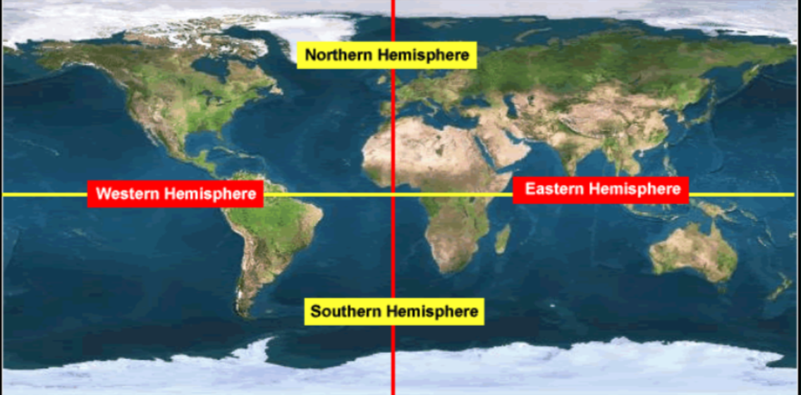
Hemispheres
Definition:
Hemisphere:are used to divide the earth into quadrants (quarters), using the cardinal points as a reference.
Northern Hemisphere, Southern Hemisphere,Eastern Hemisphere,Western Hemisphere
 ——————————————————————————————————————————————————————-
Latitude and Longitude
We us Longitude and Latitude to place the lines that distinguish one
hemisphere from another
Latitude: There are 90 degrees of latitude in two directions, both North and South. They are known as parallels, and their starting point is at the equator.
Longitude: There are 180 degrees of longitude in two directions, East and West. They are known as meridians, and their starting point is the Prime Meridian.
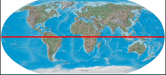
Importance of the equator
Equator: the line that runs horizontally along the center of the earth. It is equally distant from each of the poles. (0 degrees N and S)
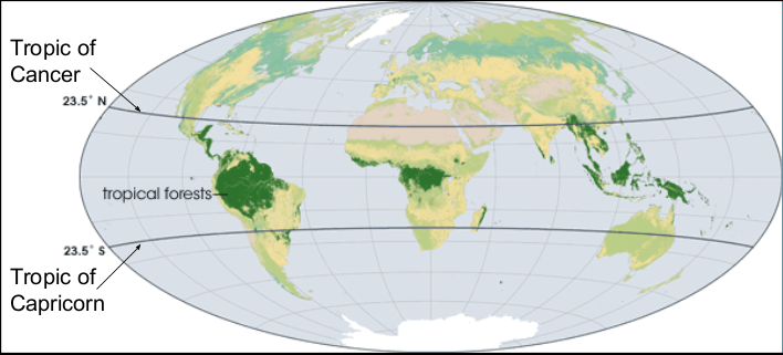
 The Tropics: Cancer and Capricorn
Tropic of Cancer: horizontal line at 23.5 degrees north of the equator. It is the northern limit of direct sunlight.
Tropic of Capricorn: horizontal line at 23.5 degrees south of the equator. It is the southern limit of direct sunlight.
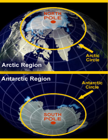
 The Circles: Arctic and Antarctic
The Arctic Circle: Horizontal line at 66.5 degrees north of the equator.
The Antarctic Circle:Horizontal line at 66.5 degrees south of the equator.
*Each receive no sunlight at opposite times during the year.
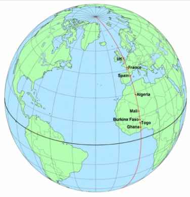
 The Prime Meridian
Prime Meridian: A vertical line that extends from one pole to the other (signifies0 degrees of longitude).It passes through Royal Observatory at Greenwich, England (part of London). It also passes through France, Spain, Burkina Faso, Mali, Togo, and Ghana.
 International Date Line
International Date Line: A vertical line that runs from one pole to the other. It
is exactly opposite to the Prime Meridian, and is considered 180 degrees, East and West.
his line passes through the pacific ocean.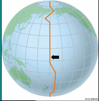 ——————————————————————————————————————————————————————
Map scale
Geographers need an accurate and consistent method to represent features on the Earth’s surface on a map. Therefore, the concept of scale was developed.
Scale is a measurement on a map that represents an actual distance on the Earth’s surface.
Scale is a relationship between actual distances and mapped distances. Scale can be represented in three different ways: (Pros and Cons to each)
Direct (Verbal) Statement (DS): a statement about a distance on the map in comparison to the represented distance in the real world.
e.g. “one centimetre represents four kilometres”
“three centimetres represents eight kilometres”
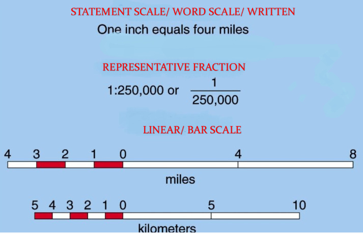 Linear Scale (LS): a straight line divided into units which can be used for measuring distance on a map.
Representative Fraction (RF): a fraction that involves no mention of units. Because units are ignored, whatever you assign to one side must be assigned to the other.
e.g. 1: 50 000 could become,
1 cm : 50 000 cm or,
1 m : 50 000 m or,
1 “size 11 boot” : 50 000 “size eleven boots”
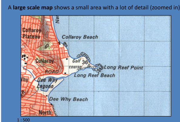
Large Scale and Small Scale Maps
Scale determines the amount of detail a map will show.
Small Scale Maps: show a small amount of detail over a large area.
e.g. 1:250 000, 1:500 000
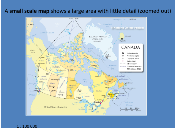 Large Scale Maps: show a large amount of detail and a small area.
e.g. 1:50 000, 1:25 000
*a map of the world that fits on an 8.5 x 11 inch piece of paper has a scale of 1: 100 million.
 ——————————————————————————————————————————————————————
Time zones
Longitude and time
The Earth rotates, or turns, one complete circle every 24 hours
A circle has 360 degrees
If we divide 360 degrees of longitude by 24 hours, we get 15 degrees per hour
The Earth rotates 15 degrees of longitude every hour
If you have a friend living 15 degrees of longitude to the east, the time there will be one hour later than your time
Time zones
As the Earth rotates, the sun is always directly over some point of longitude
At that point, it is noon
There are 24 time zones, one for each hour on the clock
Every place within a single time zone sets its clock to the same time
Ideally, each time zone stretches 15 degrees from east to west, and all the way from the North Pole to the South Pole
In reality, many countries shifted the time zone boundaries to match their own political boundaries
There are a few half-hour time zones in the world including Newfoundland
They set their clocks a half-hour ahead of the Atlantic region of Canada because they are slightly East of the other provinces\