Meteorology 1
Reports are observations of current weather conditions either taken by a human observer or
sensors.
Forecasts are predictions of future weather based on trends observed in reports and knowledge of common weather patterns.
pilot briefing
Aka aviation weather briefing services (AWBS)
A briefing service provided by NAV CANADA Flight Information Centers (Fle) to assist pilots during pre—flight planning and while en route.
Flight Service Specialists (FSS) are able to provide briefings, consultations and advice to pilots as they are highly trained to interpret meteorological reports and forecasts.
They can be contacted by phone at 866-WXBRIEF.
While en route, FSS can be contacted on the frequency found in the Canada Flight Supplement (CFS) or on a VNC.
Automatic Terminal Information Service
ATIS is a continuous broadcast of recorded information for arriving and departing aircraft.
Its purpose is to reduce frequency congestion by providing essential information to pilots before they contact the appropriate air traffic controller.
You must listen to the ATIS (if available) before contacting tower for take—off and before entering the control zone when landing.
CAVOK
No cloud below 5000 feet and no cumulonimbus clouds
Visibility is 65M or more
No precipitation, thunderstorms, shallow fog, or low drifting snow
weather reports
METAR
AWOS
PIREP
AIRMET
SIGMET
METARS
Coded weather observations taken by a qualified person every hour on the hour of the actual weather observed on the ground.
SPECI is used when significant changes in weather conditions occur off the hour.
CCA indicates a first correction has been made (CCB indicates a second correction, CCC is a third correction and so on).
routine meteorological report
METARs are actual weather conditions as observed from the ground. The information is gathered by a qualified human observer.
They are issued every hour on the hour and only represent the weather observed at that time. There may be slight variations in the weather between METARs.
When significant weather changes occur between scheduled METARs a special weather report known as a SPECI will be issued.
The reports are coded in a specific order and format. If a certain weather phenomena does not occur it is omitted; these are marked with an asterisk (*) on the following slide.
METAR contents
1. Report name 9. Present weather
2. Location identifier 10. Sky condition
3. Date and time of observation 11, Temperature and dewpoint
4. *Report modifier 12. Altimeter setting
5. Wind and gusts 13. *Recent weather
6. Variations in wind 14. Wind shear
7. Prevailing visibility 15. Remarks
8. *Runway visual range
1. Report name
Either METAR or SPECI will be indicated. METAR is a normal report, while SPECI is a special observations and indicates conditions are changing rapidly. More info on SPECI later in this presentation.
2. Location indicator
Reporting stations are assigned a four—character identifier by ICAO.
In Canada they start with a C followed by a W, Y, or Z.
A|l weather reporting sites are listed in the CFS
3. Date and time
The day of the month followed by time in UTC. It is assumed you know what month you are currently in.
2920002 means 29th day of the month at 2000Zulu
4. Report modifier*
The report modifier may contain two possible codes
AUTO is used when data for the report is gathered by an automated weather observation system (AWOS)
CCA is used to indicate a correction has been made to the original report.
CCA indicates a first correction. CCB indicates a second correction, and so
on
5. Wind and gusts
First 3 digits indicate direction the wind is coming from in degrees true
rounded to the nearest 10°.
Speed in knots is indicated by at least 2 digits. G indicates a gust.
Gusts are included if the gust factor is at least 5kts stronger than the average
wind speed and the total wind speed is at least 15kts.
30015625kt is decoded as winds coming from 300°True with average wind
speeds of 15kts and gusts up to 25kts
5. Wind and gusts
First 3 digits indicate direction the wind is coming from in degrees true rounded to the nearest 100.
Speed in knots is indicated by at least 2 digits. G indicates a gust.
Gusts are included if the gust factor is at least 5kts stronger than the average wind speed and the total wind speed is at least 15kts.
30015G25kt is decoded as winds coming from 3000 True with average wind speeds of l5kts and gusts up to 25kts
6. Variations in wind*
Included only if wind direction varies 600 or more over 10 minutes prior to publishing the report.
Directions are coded clockwise separated by a V
260V340 means wind direction is changing between 2600T and 3400 T.
7. Prevailing visibility
Reported in statute miles
If there are areas around the aerodrome with visibilities of half or less of the prevailing visibility it will be include in the remarks
In the example above, the prevailing visibility is 3/4 statute miles but to the
northwest of the aerodrome visibility is only 3/8 statute miles.
8. Runway Visual Range (RVR)*
Average visibility over 10 minutes from the touchdown zone of up to four runways.
Only included in a report if the prevailing visibility is 15M or less or if the
RVR is 6000' or less
R indicates it is an RVR.
R is followed by the runway the visibility is being reported for, then visibility
in feet or hundreds of feet and a trend indicator of D, U, or N which mean downward, upward, or no distinct change respectively
Ex. R33/4000FT/D means the visibility from the TDZ of runway 33 is 4000
feet and is expected to become worse.
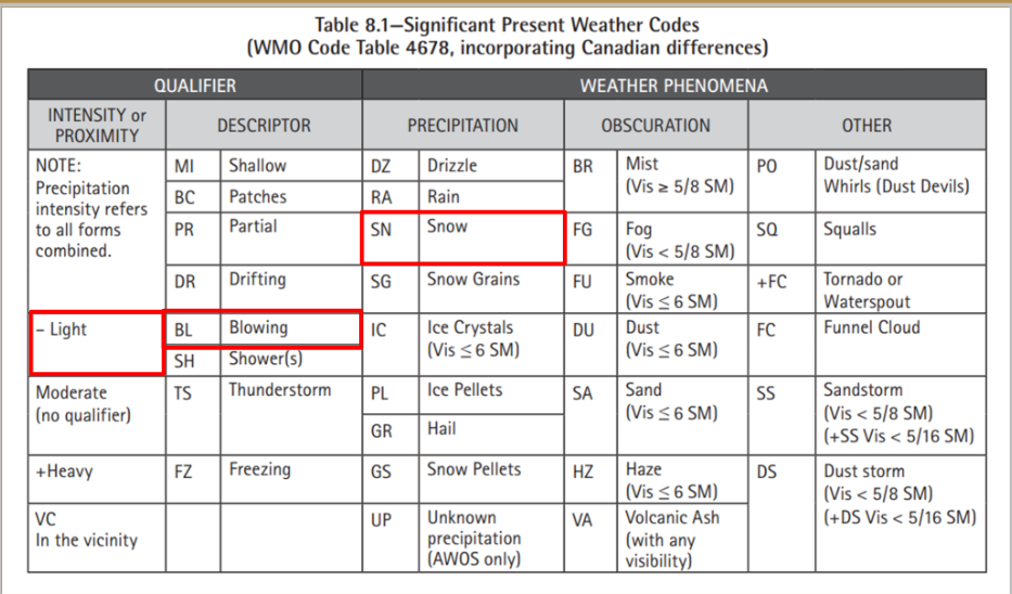
9. Present weather
Present weather includes any precipitation or obscuring phenomena. It is essential to remember all codes detailed in the present weather codes table
from the TC AIM
SN BLSN means light snow and blowing snow
10. Sky condition
There are 5 sky conditions based on cloud coverage used in weather reports and forecasts.
The sky is divided into 8 segments called oktas.
Coverage is determined by the number of oktas that can be filled with clouds.
BKN and OVC are considered "ceilings" for VFR pilots. They cannot fly above these clouds.
The height of the cloud base will be indicated in hundred of feet above ground level (AGL). Convective cloud will be indicated if they are present at that height. EN K008 means there are 5-7 oktas of clouds at 800 feet AGL.
Obscured sky (vertical visibility)
When the sky is obscured 3 digits preceded by W indicate the visibility in hundreds of feet.
Vertical visibility is also considered a ceiling because a pilot can not see the ground above
that height.
11. Temperature and Dew point
Given in degrees Celsius. Negative values are preceded by the letter M.
MOS/M08 decode as a temperature of -5°C and a dew point of -8°C.
12. Altimeter setting
An A followed by four digits.
Place a decimal after the second digit to decode the pressure reading into inches of mercury.
A2992 decodes to 29.92 inches of mercury.
13. Recent weather
Preceded by RE
May include freezing precipitation,- moderate or heavy rain, drizzle or snow; moderate or heavy ice pellets, hail, or snow pellets; moderate or heavy
blowing snow,- sandstorm or dust storm; thunderstorm,- or volcanic ash.
REFZRA is recent freezing rain
14. Wind Shear
Low Level Wind Shear within 1500' AGL along take off or approach path of a
runway will be indicated.
WS RWY33 means wind shear was encountered on runway 33.
15. Remarks
Preceded by RMK
May include cloud type and coverage (in oktas), general weather remarks, sea level pressure, and density altitude.
The above red section decodes to: the broken layer at 800 feet consists of 5 oktas of stratus fractus clouds; the overcast layer at 4000 feet consist of 3 additional oktas of stratocumulus clouds; visibility to the northwest of the aerodrome is 3/8SM; sea level pressure is 1013.4 hectopascals.
AWOS
Weather observed using AWOS will be shown as METAR AUTO or SPECI AUTO.
Weather cams are usually installed at these locations to verify weather conditions since a
wisp of cloud across a sensor can cause incorrect observations.
LWIS
A more basic system than AWOS.
The LWIS collects limited meteorological data, produces LWIS reports and transmits data to ATS facilities on the hour.
LWIS must comply with TC requirements and will provide information on:
a) Wind direction, speed, and gusts
b) Altimeter setting
c) Air temperature
d) Dewpoint
AUTO
AUTO reports are all other types of automatic aviation weather reports that report fewer than
the four required elements of a LWIS report.
AUTOs meet TC requirements and can be used for IFR flights.
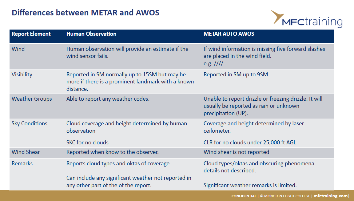
METAR/AWOS differences
There are some key differences between METARs made by human observation and METAR
AUTOs by an AWOS.
The following slide contains a table of differences. Any elements with no difference are not
included.
SPECI reqs
Special observations will be taken to report changes between scheduled reporting times.
The following 10 changes constitute a SPECI being created:
1. Ceiling
If there was a significant change in a ceiling that is 1500' or lower.
2. Sky condition
If a layer is observed below 1000 feet when there was no layer previously reported below
this height.
3. Visibility
Prevailing visibility decreases to less than 35M or fluctuates between visibilities below
35M.
4. Tornado, waterspout, or funnel cloud
If any of the above appear, disappear, or is reported by the public.
5. Thunderstorms
If a TS begins, increases in intensity to become heavy, or ends(with no TS activity observed
for 15 minutes).
6. Precipitation
If precipitation begins, ends or changes intensity.
7. Obstruction to vision
A SPECI is issued to report the beginning or end of freezing fog.
8. Wind
If the wind speed suddenly increases to double to previously reported value and is above
30 kts
If wind direction changes sufficiently to fulfill criteria required for a "wind shift"
9. Temperature
If temperature increases by 5°C or more ifthe previously reported value was 20°C or more.
Decreases to a reported value of 2°C or lower.
10.Volcanic eruption
A SPECI shall be issued when a volcano erupts
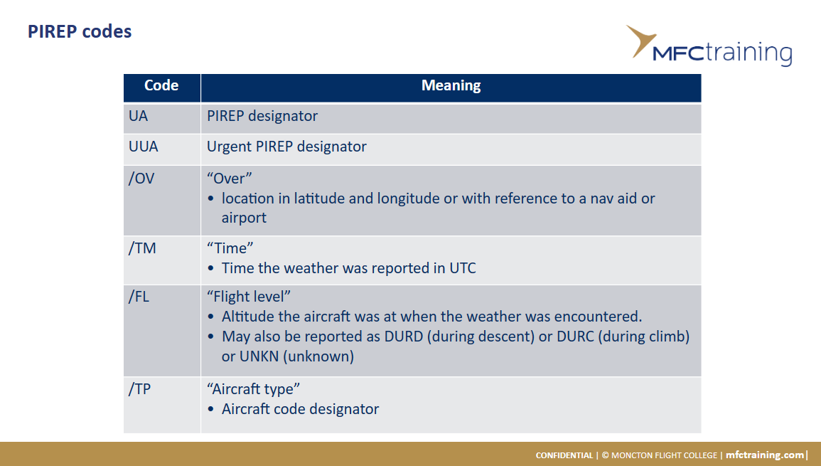
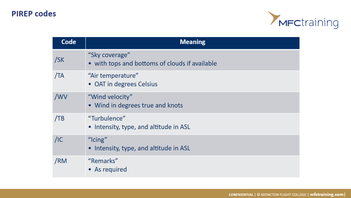
PIREPS (pilot reports)
Pilots are urged to volunteer reports of cloud tops, upper cloud layers, cruising level wind
velocity, and other meteorological information which may be significant to safe or
comfortable flight conditions.
The information is also used to update or confirm weather forecasts.
They are issued as reported and at the time of report.
“UACN10" or "UA" is used when reporting normal PIREPs.
"UACN01" or "UUA" is used for urgent PlREPs.
The suggested format when calling in a PIREP can be found on the back cover of the CFS.
AIRMET
A message issued by the meteorological watch office (MWO) to advise pilots of any weather
that may affect safety, which was not already included in a Graphic Area Forecast (GFA).
It will include any potentially hazardous conditions up to an including 24,000 feet.
WA designates an AIRM ET.
SIGMET significant in-flight weather warning messages
A message issued by the MWO to advise pilots of serious weather conditions that may affect the safety of aircraft operations.
There are 3 types of SIGMETs:
WS SIGMETs for thunderstorms, icing, mountain waves, low level wind shear, dust storms,
sandstorms, and radioactive clouds
WC SIGMETs for tropical cyclone
WV SIGMETs for volcanic ash
Reported as a WARNING to aircraft in flight.
WS is the most common type of SIGMET.
Forecasts
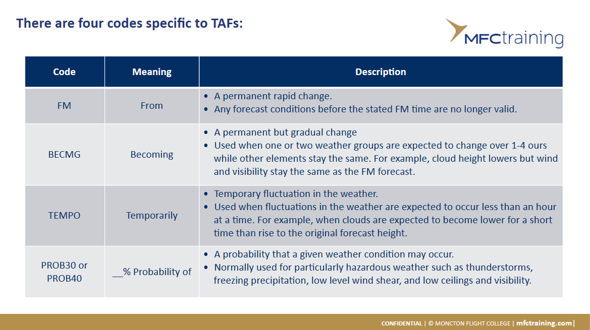
TAF
GFA
Upper winds
TAF
An aerodrome forecast gives the expected weather
conditions within a 5NM radius of the aerodrome with
the most probable time of occurrence.
TAFs are generally issued four times per day up to 30
minutes before the validity period. Validity times may vary
but they can be valid for up to 30 hours; the next issue
time is stated at the end of each TAF.
TAFs are coded similarly to METARs.
Winds are in degrees TRUE and cloud heights are given in
hundred of feet AGL.
graphic area forecast
Weather conditions to be expected over a particular
region at or below 24,000'.
New charts are published four times per day with
validity periods of 00002, 0600Z, 1200Z, and 18002.
The charts are issued approximately 30 minutes
before the validity time.
There are seven GFA domains readily available with
one more near the Arctic domain available upon
request.
graphic area forecast
There are two types of GFA charts:
1. Clouds and weather
2. Icing, turbulence, and freezing level 6 charts are issued four times per day.
Two charts valid at the beginning of the forecast period
Two charts valid 6 hours in the future
Two charts valid 12 hours in the future
There is an additional 12 hour forecast on the 12 hour clouds and weather chart that can be used for IFR
Faint outlines of land masses with the locations of main
airports are on both types of GFAs.
All speeds are expressed in knots.
All heights are in hundreds of feet ASL until otherwise noted.
Horizontal visibility is measured in statute miles.
Only standard meteorological abbreviations are used in a GFA.
Symbols on a GFA are the same as those found on other graphic meteorological charts such as the significant weather prognostic charts.
each GFA has four sections
Title Box
Legend Box
Comments Box
'Weather Information Box
title box
Chart Name
Issuing office
Region
Chart type
Date and time in UTC of Issue
Date and time in UTC the chart becomes valid
legend box
The legend box will contain difference symbols depending on the type of GFA chart.
Clouds and weather GFAs will have:
Thunderstorms (TS)
lce pellets (PL)
Freezing rain (FZRA)
Freezing drizzle (FZDZ)
Icing, Turbulence, and Freezing level GFAs will have:
Moderate icing (MDT ICG)
Severe icing (SEV ICG)
Moderate turbulence (MDT TU RB)
Severe turbulence (SEV TU RB)
In addition to meteorological symbols both types of charts will have a nautical mile scale to help determine distances.
Pressure or frontal systems will often have an associated direction and speed.
Using the distance scale, we can measure where certain weather will be between forecast validity periods.
spatial coverage qualifiers
Within a larger area, there could be spatial qualifiers that indicate specific weather for a part of
the area.
The qualifier changes depending on if the weather forms in unstable, convective air or stable, non-convective air.
decoding an FD upper wind and temp forecast
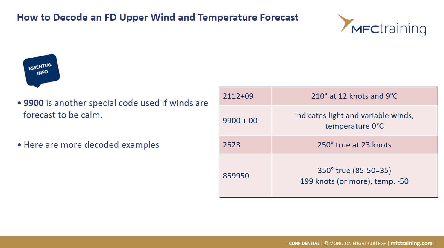
need to be able to read both FDs and FBs