Land
Earth’s layers:
Crust
Upper mantle
Lower mantle
Outer core
Inner core
*The crust and upper mantle make the lithosphere
*Upper and lower mantle is the Asthenosphere
Rock Cycle: The process of rock turning into three categories: sedimentary, metamorphic, and igneous.
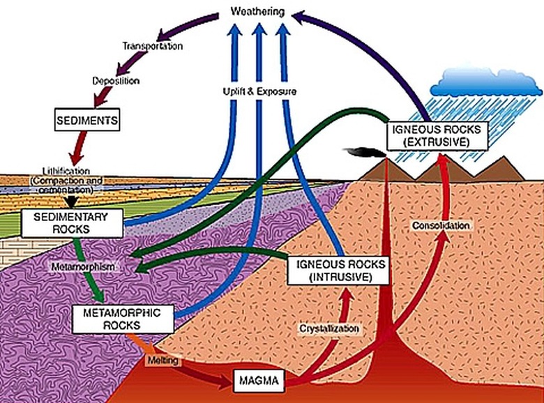
Plate Tectonics
Panagea- supercontient. All continents were once together about 200 million years ago.
Convergent Boundary Two tectonic plates are heading towards each other. | Transform Boundary Two tectonic plates sliding against one another. | Divergent Boundary Two tectonic plates pulling away from each other |
Tsunamis- Occur at a convergent boundary beneath the ocean. A huge amount of water is lifted, starting a wave.
Volcanoes- Convergent boundaries, subduction zone, magma rises to the surface.
Islands- A hot spot (magma underneath); magma rises to the surface, then cools in rock.
The hot spot is stationary, the island moves and the hot spot creates another island.
Island chains
Flooding and Foodplains
Floodplain: Lower (flat) region of land next to a river.
Flooding: River floods, but within the floodplain.
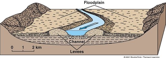
Deposition: The placing of water particles/materials in a new location.
The formation of a levee
slow
Erosion: The removal and transportation of particles/materials
The stream channel moves
fast
Reservoirs and dams were created to prevent rivers from overflowing.
Flood factors:
Dam/reservoir overflow
Heavy rain
Soil type
Impermeable surface- covered soil/no soil (cement) Urban areas.
Channel geometry- the amount of space for water to spread
Catchment area- the amount of area rain captures
Aggregation- The levee grows taller due to deposition.
Minerals
Inorganic solid materials- made of elements or one element
*coal/fossil fuels are NOT minerals
How minerals are collected:
Subsurface mining- Involves the extraction of minerals and resources from beneath the Earth's surface, usually via tunnels or shafts.
Surface mining- involves the removal of the overburden (the soil and rock covering a mineral deposit) to access resources near the surface.
Techniques include strip mining, open-pit mining, and mountaintop removal mining.
Pit mining - A specific form of surface mining that entails digging a large pit to access minerals, typically in an open-pit format.
The process includes blasting, drilling, and removing large quantities of soil and rock to access the mineral deposits.
California Mining: Glod Rush 1849
Hydraulic mining- The process begins by creating a water supply, often from nearby rivers or reservoirs, which is then directed through hoses. The high-pressure water jets are aimed at the gold-bearing rock, effectively eroding it and washing the debris into sluice boxes to capture the gold. Ban in 1884.
Impacts:
Loss of habitat
Tailings
Erosion/sedimentation
Sinkable
Acid drainage
Toxins released
Health problems
Soil
Ideal soil:
Water- 25%
Organic- 5%
Mineral- 45%
Air- 25%
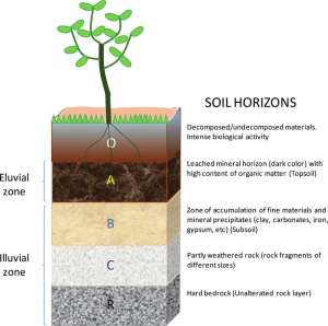
Horizon layers:
Topsoil (O)- organic material/ humus
Topsoil (A)- Mixed in organic material
O and A is the zone of leaching.
Leaching is the process of dissolving minerals/materials.
Subsoil (B)- Inorganic- dissolved nutrients
Zone of accumulation
Accumulation is the build-up of dissolved minerals/materials.
Weathered bedrock (C)
Solid bedrock (R)
Protecting Topsoil:
Dustbowl- wind blows topsoil away
Central valley- Salinzation
Soil Profiles:
Desert'
Temperature
Tropical
Deforestation due to leaching, not enough nutrients to help grow.
Water
97.5% saltwater
1.7% of freshwater- frozen within glaciers
< 1% usable water- in aquifers (groundwater), rivers, and lakes.
Frozen water:
Glaciers
Permafrost- frozen ground.
Snowpacks (usable)- melt and feed rivers/lakes.
Usable water:
Surface and groundwater
Runoff- active/excess water that land wasn’t able to absorb.
Watershed- a land area that collects and drains water into a common body of water.
Smaller sub-water sheds join and form a larger watershed.
Overland flow, rainfall
Wetlands- areas of land saturated with water, either permanently or seasonally.
Importance: support biodiversity, ecosystem services (filter water), percolation, and reduce flooding.

Create wells to collect groundwater deep enough for the unconfined or confined aquifer.
As you pump water out of the well, it creates a cone of depression.
Confined- limited, moves 1 foot a century
Unconfined- renewable, moves 1 foot a year/day.
The water table can go up and down. River water rises, and so does the water table.
Overdrawing Problems
Taking out water faster than it can renew.
Subsidence- sinking, losing groundwater storage. (Air in the gaps of soil)
Can recharge aquifers based on soil type.
Saltwater intrusion- occurs when wells are located near coastal areas. Since saltwater is denser than freshwater, it can sink below the groundwater. If wells are pumped too closely to the shoreline, saltwater can enter the groundwater supply.
Sustainable Groundwater Management Act 2014
Agencies formed for each basin (watershed) at risk.
Plans to prevent “undesirable” results.
The goal is to have sustainable water use by 2040.
Monitoring those with wells, limiting groundwater use.
Flood Control:
Channelized water- surrounded water with concrete.
Channelization- Reservoirs, dams, man-made lakes
Cons: Blocks migration of fish/aqua animals from going upstream.
Damages animals
Sedimentation- particles staying in water. Losing sand as most of our sand comes from rivers.
Displacement of people.
Aqueducts- active water being pumped to several locations.
Water Pollution
Two different categories based on source.
Point Source:
From pipes
Sewers
Industrial
Livestock, farm animals, waste entering nearby water. (animal feedlot)
Non-point Source:
Water intrusion from rain
Crop water
City rain runoff
Rural homes
A lot of pollution is nutrients.
Oxygen Sag Curve:
Oxygen levels drop due to nutrient/bacteria pollution.
Oxygen naturally occurs and flows at high levels.
Slowly recovers, but damages the ecosystem and aqua animals.
Pathogen Pollution- Human death from bacteria, fungi, viruses, and other pathogens.
Other pollutants:
POPS- Persistent organic pollutants that are man-made.
Stay in the atmosphere too long, causing health problems
Heavy metals
Oil
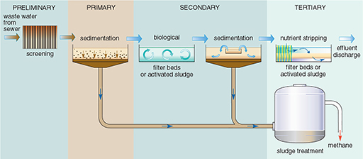
Wastewater Treatment
Preliminary- screening
Primary- sedimentation- sediment is taken away
Secondary-
biological- filter bed- put good bacteria- constantly moving for oxygen
sedimentation- UV, O3, Chorline - kills bad bacteria
Tertiary (optional)-pull out nutrients using filter beds- throw away(not good for drinking)/ recycle water.
Used for non-human food crops and construction because they need lots of water.
Conserving Water
Mainly used for irrigation '
Some power sources use a lot of water
Water Footprint:
How much water countries/ per capita are using.
Household water use
Virtual Water:
Not directly using.
A water bottle takes more water to make than it holds.
Amount of water used to produce food.
Beef- 1,850 gallons to feed the cows.
Amount of water used to produce products.
Pair of blue jeans- 2,900 gallons.
Alfalfa- a type of grass that requires a huge amount of water to grow.
Feeds livestock in the winter.
Water conservation:
Gray water systems- water from a household (toilets, sinks, washer) goes int a surge tank and is reused.