EAS 209 - Lecture 30
Barnum Brown
Lived from 1873–1963.
Worked for the American Natural History Museum.
Grew up on a farm.
Family reportedly struggled to choose a name for him after birth.
Eventually named after P.T. Barnum of Barnum Circus when the circus passed through town.
Attended Kentucky University.
Became involved in fossil collecting while assisting a professor with fieldwork.
Quickly demonstrated exceptional skill at locating fossils.
Developed a reputation as a naturally gifted fossil hunter.
Enjoyed fieldwork far more than classroom-based academic work.
Obtained employment with the American Natural History Museum while still at university.
Left university temporarily to pursue fossil collecting professionally.
Later accepted into graduate studies at Columbia University despite not having completed his undergraduate degree.
Did not complete graduate studies and eventually left Columbia.
Ultimately returned to Kentucky University and completed his undergraduate degree.
Became one of the most successful fossil collectors in history.
Discovered Tyrannosaurus rex.
Discovered numerous other dinosaur fossils.
Many major dinosaur museum collections around the world originated from fossils collected by Barnum Brown.
Contributed substantially to the development of dinosaur paleontology.
Known for conducting fieldwork while wearing a large fur coat.
Demonstrates that scientific success can come through exceptional field skills, not only academic study.
Recognized as an important scientist despite not following a conventional academic path.
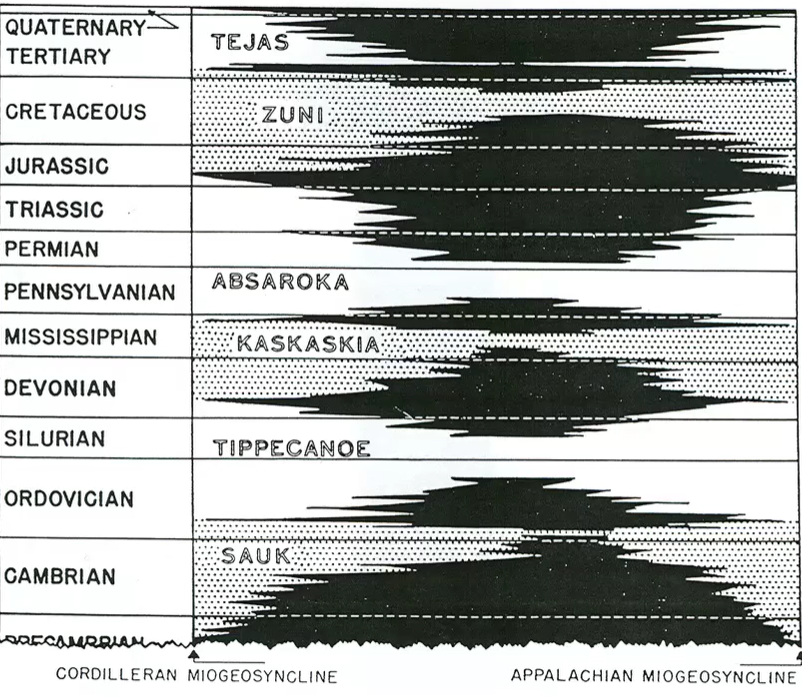
The Cretaceous Within the Zuni Sequence
The Cretaceous belongs to the Zuni Sequence.
Sea level continued rising through much of the Cretaceous.
Peak sea level occurred during the middle-to-late Cretaceous.
At maximum flooding:
Marine waters extended from the Cordillera in western North America to the Appalachians in the east.
Much of the continent was submerged.
Minor unconformities occurred during the sequence.
These unconformities did not necessarily extend across the entire continent.
After maximum flooding:
Sea level began to fall.
Regression followed the transgressive phase.

Global Geography During the Cretaceous
Example shown at approximately 100 million years ago.
Pangea was actively breaking apart.
South America and Africa were separating.
North America was split by a major inland seaway.
Antarctica still existed as a recognizable landmass.
India was isolated and moving northward.
India eventually collided with Asia.
Collision between India and Asia formed the Himalayas.
By approximately 80 million years ago:
Continental positions more closely resembled modern geography.
Inland seaway still divided North America.
Global sea level remained very high.
Comparison between 100 Ma and 80 Ma demonstrates continued sea-level rise during the Cretaceous.
Completion of Cordilleran Assembly
By the Cretaceous, most terrane accretion had already occurred.
Major components of British Columbia had largely assembled.
Components included:
Island arcs.
Ancient ocean floor fragments.
Continental fragments.
Submarine deposits.
Most of modern British Columbia was already present by this time.
Foreland Basin Formation
Himalaya–India collision used as an analogy.
Collision concentrates large amounts of crustal mass.
Concentrated mass causes loading of the lithosphere.
Lithosphere bends downward adjacent to mountain belts.
Resulting depression forms a foreland basin.
Similar process occurred beside the Cordillera.
Accreted terranes and mountain building loaded western North America.
Weight of mountains caused crustal sagging.
Sagging created the Alberta Foreland Basin.
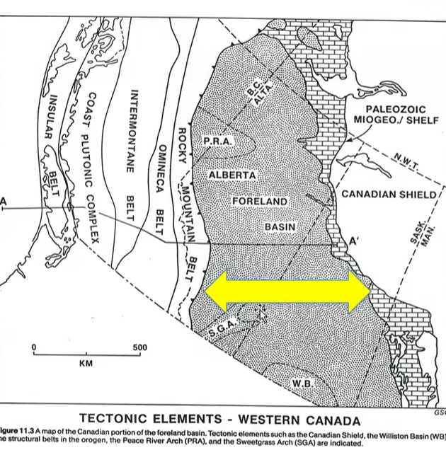
Alberta Foreland Basin
Primary location of Cretaceous sediment accumulation.
Formed because of loading associated with Cordilleran mountain building.
Basin was:
Wide.
Stable.
Long-lived.
Stability allowed development of:
Rivers.
Deltas.
Coastal plains.
Swamps.
Basin experienced relatively little tectonic activity after formation.
Became an ideal sediment trap.
Note: the Rocky Mountains is also known as the Foreland (Fold and Thrust) Belt.
Cordilleran Belts
Rocky Mountain Belt.
Omineca Belt.
Intermontane Belt.
Coast Belt.
Insular Belt.
These belts reflect different tectonic terranes and geological histories within the Cordillera.
Change in Sediment Transport Direction
Earlier Paleozoic successions commonly received sediment from the east.
Development of the Cordillera created a new western highland source.
During the Cretaceous:
Sediment was shed from west to east.
Newly uplifted mountains became major sediment suppliers.
Sediment transport direction therefore reversed compared to many earlier intervals.
Important Structural Features
Sweetgrass Arch
Remained an important structural high.
Eventually submerged during marine transgressions.
Continued influencing sediment distribution.
Peace River Arch
Previously became a basin during Carboniferous time.
Retained structural influence.
Continued affecting sedimentation patterns.
Foreland Fold and Thrust Belt
Rocky Mountain Belt also referred to as the Foreland Fold and Thrust Belt.
Area where rocks became:
Folded.
Faulted.
Thrust upward.
Represents the deformational front of mountain building.
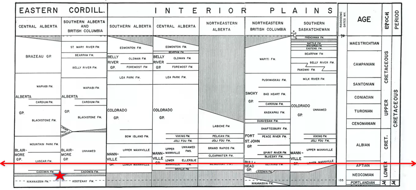
Stratigraphy Column:
Although the Nikanassin and Kootenay Formations are not completely Cretaceous in age.
Transverse that.
Cretaceous Stratigraphy Overview
Divided into:
Lower Cretaceous.
Upper Cretaceous.
Numerous regional formation names exist.
Names vary between:
Outcrop regions.
Subsurface regions.
Different geographic areas.
Important stratigraphic intervals include:
Aptian.
Albian.
Campanian.
Maastrichtian.
Relationship to Dinosaur Provincial Park Units
Belly River Group discussed previously.
Included:
Oldman Formation.
Dinosaur Park Formation.
Bearpaw Formation.
These units occur higher in the Cretaceous succession.
Current lecture focuses on older Lower Cretaceous units.
Jurassic–Cretaceous Boundary Units
Nikanassin Formation.
Kootenay Formation.
Both span the Jurassic–Cretaceous boundary.
Unique because they cross the period boundary rather than lying entirely within one system.
Major Sub-Cretaceous Unconformity
After Nikanassin deposition, a major period of erosion occurred.
Created a province-wide unconformity.
Represents a substantial gap in the geologic record.
Mountain building produced uplift and exposure.
Erosion removed large amounts of rock.
Unconformity extends across Alberta.
One of the most important surfaces in the western Canadian sedimentary basin.
Cadomin Formation
First major deposit above the sub-Cretaceous unconformity.
Represents earliest Cretaceous sedimentation after mountain building.
Consists largely of conglomerate.
Dominated by:
Quartzite clasts.
Chert clasts.
Very coarse-grained.
Contains abundant rounded pebbles.
Clast rounding indicates transport and abrasion.
Material likely eroded from uplifted Rocky Mountain source rocks.
Source of Cadomin Clasts
Chert likely derived from:
Permian deposits.
Pennsylvanian deposits.
Quartzite may have been derived from:
Gog Group quartzites.
Other resistant quartz-rich units.
Represents erosion of uplifted mountain belts.
Angular Unconformity
Mountain building tilted older strata.
Erosion truncated tilted beds.
Cadomin Formation deposited directly on eroded surface.
Relationship forms an angular unconformity.
Older rocks exposed at the surface ranged from:
Cambrian.
Ordovician.
Devonian.
Carboniferous.
Permian.
Triassic.
Jurassic.
At the beginning of the Cretaceous these rocks could have been exposed simultaneously at the land surface.
Cross-Section Through the Foreland Basin
Mountain loading created major subsidence adjacent to the Cordillera.
Thickest Cretaceous deposits accumulated closest to the mountains.
Basin deepened toward the mountain front.
Some Paleozoic units formed structural highs.
Examples include:
Rundle Group.
Banff Formation.
Wabamun Group.
Winterburn Group.
These highs influenced later sedimentation.
Origin of the Oil Sands
McMurray Formation.
Clearwater Formation.
Grand Rapids Formation.
Lower Manville Group.
Important hosts of Alberta oil sands.
Contain bitumen-rich sandstones.
Bitumen is highly viscous.
Requires:
Surface mining.
Steam-assisted recovery methods.
Different from conventional oil fields such as Leduc.
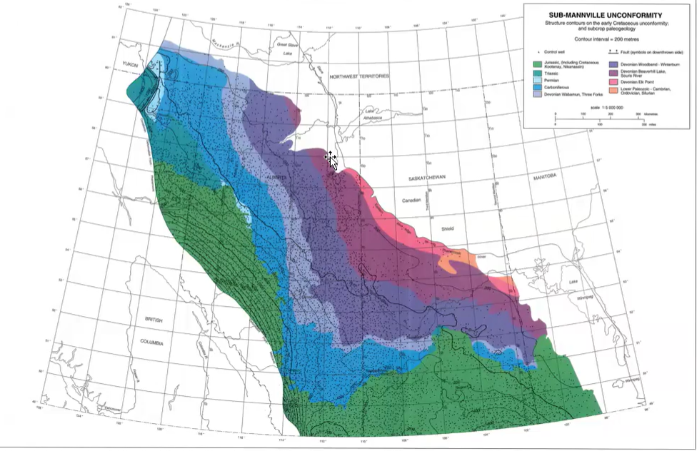

This angular unconformity is underlain by NW-SE trending subcrop belts that are progressively older from SW to NE.
The mountains pushed down all the deposits.
The squiggly line is the start of the Cretaceous.
The deposits in the Foreland Basin are thick. All the heaviness from the mountains formed a depression.
Moving east to northea
Asst → the Rundle, Banff, Wabamun, and Winterburn form a high.
Ends up bisecting the province.
Paleo-Highs and Sediment Distribution
Structural highs remained exposed during early Cretaceous sedimentation.
McMurray deposits filled low areas and valleys.
Deposits did not immediately cover all highs.
Different formations accumulated on opposite sides of structural highs.
McMurray–Gething Relationship
McMurray Formation deposited on one side of the structural high.
Gething Formation deposited on the other side.
Units are time-equivalent.
Deposited simultaneously.
Differ only because they formed in different geographic areas.
As time progresses, there is a sea level rise.
Fish Scale Zone:
A zone of fish debris practically covers the whole province as time continues to go on.
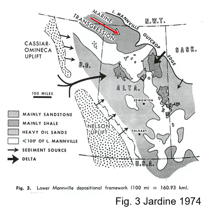
Lower Mannville Group
Thickness maps reveal locations of paleo-highs.
Following a period of erosion, invasion of the Boreal Sea occurred.
Deposits become thinner approaching highs.
Thick deposits accumulated in low areas.
Thickness therefore provides clues to ancient topography.

Cadomin Depositional Environment
The first unit to be deposited was the Cadomin Formation, a quartzite plus chert pebble conglomerate.
Cadomin Formation repesents alluvial fan and braided stream deposits flowing to NE.
Interpreted as an alluvial fan system.
Deposited along the base of newly formed mountains.
Alluvial fans formed from:
Seasonal runoff.
High-gradient streams.
Rapid erosion of uplifted terrain.
Deposits spread outward from point sources.
Comparable to cones of rubble seen along mountain fronts today.
Characteristics of Alluvial Fans
Mostly subaerial.
Formed on land.
Different from submarine fans.
Contain coarse sediment.
Deposited rapidly.
Commonly associated with:
High relief.
Steep gradients.
Active erosion.
Evidence Supporting Alluvial Fan Interpretation
Extremely coarse grain size.
Conglomeratic composition.
Limited geographic extent.
Thickest near mountain front.
Rapid thinning away from source.
Strong relationship to uplifted Cordillera.

Cadomin Thickness Distribution
Thickest adjacent to mountains.
Braided stream and braidplain deposits at foot of new mountains.
Does not extend across all of Alberta.
Restricted to western portions of the basin.
Fox Creek Escarpment marks approximate eastern limit.
Grain size becomes finer farther from source.
Demonstrates decreasing transport energy away from mountains.
Apron being formed through the erosion of the Rocky Mountains.
Flowing to the NE; thickness trends show Peace River Embayment was still active.
Cadomin Outcrop Examples
Hell's Gate Gorge
Near Grand Cache.
Displays thick Cadomin conglomerates.
Excellent exposure of alluvial fan deposits.

Kakwa Falls
Southwest of Grande Prairie.
Cadomin forms resistant cap rock.
Softer sandstone and shale occur beneath.
Water preferentially erodes softer units.
Creates overhangs and cave-like features.

Punchbowl Falls (Jasper Area)
Displays thick Cadomin conglomerate section.
Demonstrates large volume of sediment shed from early Rocky Mountains.
Transition to Gething and McMurray Deposition
After Cadomin deposition:
Large fluvial systems developed.
Major rivers crossed the foreland basin.
Depositional environments included:
Meandering rivers.
Floodplains.
Swamps.
Deltas.
River sands later became important oil-sand reservoirs.
Oil Sands Reservoirs
Hosted primarily within river-related sandstones.
Point-bar deposits especially important.
Meandering river systems produced extensive porous sand bodies.
These sand bodies later became reservoirs for bitumen accumulation.

Drainage Systems
Gething Formation sediments redistributed by NW-SE channels.
Spirit River Channel.
Edmonton Channel.
Peace River Channel.
Large river valleys transported sediment across the basin.
Rivers occupied low areas between structural highs.
A lot of these deposits have water in them.

Preservation of Continental Deposits
River migration buried floodplains and swamps.
Burial preserved:
Coal.
Plant material.
Dinosaur remains.
Floodplain sediments.
Preservation of continental environments is less common than marine environments.
Reading Manville Cross Sections
Root symbols indicate vegetated land surfaces.
Bell-shaped bodies represent river channels.
Coal layers represent swamps.
Gray shales represent marine incursions.
Stacked deposits record changing environments through time.
Marine Transgression
Sea level rose during deposition.
Boreal Sea advanced southward.
Marine shales became widespread.
Shoreline deposits developed.
Eventually marine influence spread across much of the basin.
Coal Formation Review
Swamps accumulated plant debris.
Organic matter became peat.
Burial compressed peat.
Water and volatile compounds removed.
Coal formed through compaction and heating.
Paleogeography During Gething–McMurray Time
Mountains located to the west.
Spirit River valley ran roughly parallel to mountain front.
Extensive fluvial systems occupied the basin.
Structural highs remained exposed.
Inland sea periodically advanced from the north.
Deltas formed where rivers entered marine waters.
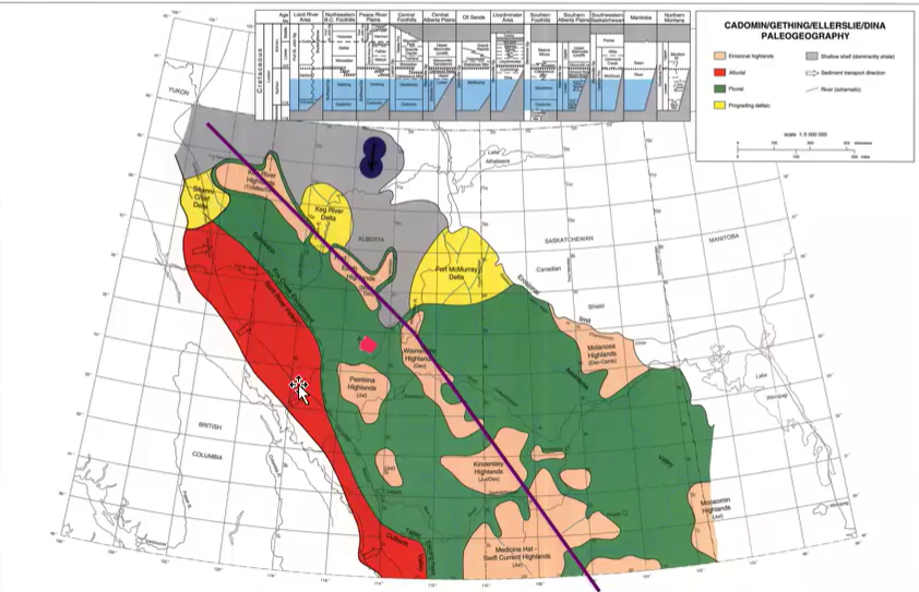
Towards the east, it thins as it onlaps a high or spine of resistant carbonates.
Glauconite
With continuing transgression of the Boreal Sea, the Gething grades into Glauconite.
A green mineral diagnostic of marine conditions.
Marine mineral.
Associated with the Boreal Sea.
Indicates marine conditions.
Presence confirms marine incursions into the basin.

ANS: False