EAS 209 - Lecture 24
Alexander von Humboldt (1769–1859)
German explorer, naturalist, geologist, botanist, and scientist.
Initially struggled academically but developed a strong interest in botany.
Worked in the mining industry while simultaneously attending lectures and collecting botanical specimens.
Known for exceptional energy, curiosity, and productivity.
Inherited wealth after his mother's death and used it to finance scientific expeditions.
Conducted extensive exploration throughout South America.
Climbed major peaks in the Andes Mountains and held a climbing speed record on one of the highest peaks for approximately 30 years.
Endured altitude sickness, fevers, and other hardships during expeditions.
Published numerous scientific works documenting observations from his travels.
Wrote more than 8,000 letters to encourage and support fellow scientists.
Personally funded scientific research conducted by other researchers.
Developed the concept of isotherms (lines connecting areas of equal temperature).
Associated with the Humboldt Equation and the Humboldt Current.
Advocated integrating science and the arts.
Considered one of the most influential scientific explorers in history.

End of the Kaskaskia Sequence
The Mississippian represents the final stage of the Kaskaskia Sequence.
Sea level continued rising into the Mississippian.
Maximum flooding occurred during the middle Mississippian.
Marine sediments extended across much of the Western Canada Sedimentary Basin.
Sea level began falling during the middle to late Mississippian.
The Kaskaskia Sequence ended shortly before the Pennsylvanian.
Falling sea level reduced the geographic extent of marine deposition.

Carboniferous Paleogeography
The Carboniferous includes the Mississippian and Pennsylvanian subdivisions.
Gondwana and Laurentia were beginning to converge.
Early stages of supercontinent Pangaea formation were underway (comes to be in the Permian).
Western North America remained an active tectonic margin.
Subduction was occurring along the western edge of Laurentia.
Island arcs developed above subduction zones.
Panthalassa Ocean formed the large global ocean surrounding much of the continents.
Paleo-Tethys Ocean developed within the assembling supercontinent.
These tectonic processes were important for the future development of western Canada and British Columbia.
Mississippian Terrestrial Environment
Alberta remained in tropical latitudes but had migrated approximately 15° northward from its Devonian position.
Conditions remained warm but were slightly farther from the equator.
Extensive swamp environments developed.
Large lycopod trees and other primitive tree-like plants dominated landscapes.
Distinctive bark patterns produced recognizable fossil impressions.
Seed-bearing plants continued diversifying.
Amphibians and early reptiles became increasingly important terrestrial vertebrates.
Giant insects were characteristic of Carboniferous ecosystems.
Extensive swamp deposits later became major coal-forming environments.
Most of the coal in Alberta comes from the Mississippian or some of the Cretaceous deposits.
Carboniferous Coal Formation
Thick accumulations of plant material accumulated within swamps.
Burial and preservation of organic matter led to coal formation.
Much of Alberta's coal resources originate from Carboniferous deposits.
Additional major coal deposits formed during the Cretaceous.
Carboniferous swamp environments are therefore economically significant.

Mississippian Stratigraphy
Devonian deposits are overlain by the Exshaw Formation.
The Exshaw Formation is overlain by the Banff Formation.
The Banff Formation is overlain by the Rundle Group.
The Rundle Group is overlain by the Mattson Group.
The Banff, Rundle, and Mattson units are the major Mississippian stratigraphic divisions discussed in this course.
Squiggly lines on the chart represent unconformities.
Major Mississippian Stratigraphic Units
Banff Formation.
Rundle Group.
Mattson Group.
Unconformities in Image
Squiggly contacts on stratigraphic columns represent unconformities.
Unconformities indicate periods of erosion or non-deposition.
Straight contacts indicate conformable deposition.
Conformable deposition represents continuous sediment accumulation without interruption.
The presence or absence of unconformities varies throughout the basin.
Some locations preserve continuous deposition while others record significant gaps in the rock record.
Time Gaps in the Stratigraphic Record
Greyed-out regions on stratigraphic charts represent intervals lacking preserved deposition.
Absence of rock does not necessarily mean nothing occurred during that time.
Deposits may never have formed or may have been removed by erosion.
Preservation varies considerably between different parts of the basin.

Major Regional Unconformities
The Devonian surface is considered a major unconformity.
The top of the Kaskaskia Sequence is also a major unconformity.
The upper Kaskaskia unconformity is commonly angular.
Angular unconformities form when rocks are tilted, uplifted, and eroded before younger sediments are deposited.
Mountain-building events contributed to development of these unconformities.
Loss of Devonian Reef Builders
The tabulate-stromatoporoid reef community went extinct during the Devonian extinction.
The craton was initially within tropical latitiues, but by the end of the Kaskaskia, northward migration by as much as 15 degrees latitude had occurred.
Marginally away from the equator.
Beneficial because swamps formed.
To backtrack to the Devonian, it appears by the mid-Devonian, the western margin had switched to an active one, with convergent plate tectonics.
Tabulate corals disappeared during the Frasnian–Famennian extinction event.
Stromatoporoid reefs also disappeared during the extinction.
Mississippian carbonate systems therefore differed from Devonian reef ecosystems.
Carbonate deposition continued despite loss of these important reef-building organisms.
Development of the Western Margin
Laurentia originally possessed a passive western continental margin.
Active tectonism began during the Devonian.
Subduction developed along the continental edge.
Mountain building began along western North America.
The Antler Orogeny produced the Antler mountain belt.
Orogeny refers to a mountain-building event.
Island Arc Development
Subduction generated volcanic island arcs.
Island arcs consisted of chains of volcanic islands similar to modern Hawaii.
Additional island arcs were transported toward the continent on oceanic crust.
Basins formed between island arcs and the continental margin. Basin that separates the island arc from the shore (inner arc basin).
Carboniferous - BC begins forming via subduction as time progresses.
These tectonic environments became important building blocks of future British Columbia.
Slide Mountain Ocean
A small ocean basin known as the Slide Mountain Ocean formed during the Carboniferous.
Continued convergence caused progressive subduction of this ocean basin.
Most of the basin was eventually destroyed.
Only small remnants remain preserved within western Canada.
Formation of British Columbia
British Columbia did not yet exist in its modern form during the Devonian.
Crustal fragments were progressively accreted onto western North America.
Terranes were added through repeated tectonic collisions.
Each accreted terrane represents a fragment of crust with a distinct geological history.
The process has been compared to repeatedly spreading layers of peanut butter onto bread.
This prolonged accretion explains the geological complexity of British Columbia.
Mystery of the Peace River Arch and West Alberta Ridge
The Peace River Arch and West Alberta Ridge were positive topographic highs during the Devonian.
During the Carboniferous both structures collapsed and became basins.
The Peace River Arch became the Peace River Embayment.
The West Alberta Ridge became the Prophet Trough.
The mechanism responsible for this collapse remains uncertain.
Some hypotheses suggest oblique tectonic compression may have produced extension in the basin interior.
Missing stratigraphic intervals make interpretation difficult.

Antler Orogeny Tectonic System
It is suggested Devonian-Mississippian event… the Antler Orogeny, or Cariboo Orogeny in NEBC.
Crust is subducting → rock melting → volcano formation. Other arcs are being carried towards the continent at the same time, hence a depression forms.
Compression = mountains are built.
Faulting also occurs, leading to horse and grobins.
Horses are upward parts and grobins are the collapsed parts in between the horse.
A prism forms with the slices of sediment.
Subduction generated volcanic arcs.
Oceanic crust descended beneath continental crust.
Partial melting produced magma and volcanic activity.
Compression produced mountain building.
Forearc basins developed between volcanic arcs and open ocean.
Backarc basins developed landward of volcanic arcs.
Foreland basins developed adjacent to mountain belts.
Sediment derived from mountains accumulated within these basins.
As more mass is accumulated, there’s compression on the crust called foreland basin.
Cratonic platform = undisturbed continental crust.
Major Tectonic Elements
Forearc basin.
Island arc.
Backarc basin.
Orogenic belt.
Foreland basin.
Cratonic platform.
Foreland Basin Development
Growth of mountain belts increased crustal loading.
The continental crust flexed downward beneath this load.
Flexure created a foreland basin adjacent to the mountains.
Thick sediment accumulations filled the basin.
Foreland basins became major depositional centres during the Mississippian.
Kootenay Terrane
The Kootenay Terrane represents crust accreted to western North America.
It formed part of the tectonic system associated with Carboniferous subduction.
The terrane contributed to later development of British Columbia.
Different accreted crustal fragments are assigned different terrane names.
Prophet Trough
The Prophet Trough developed where the West Alberta Ridge previously existed.
It formed part of the foreland basin system.
It served as an important sediment accumulation area.
Thick Mississippian deposits accumulated within the trough.
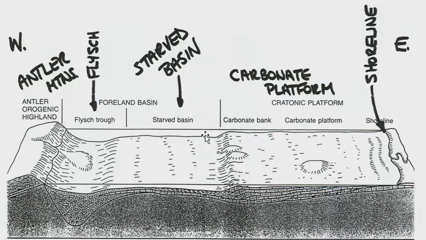
In Laurentia (image).
Foreland basin = where mountain deposits go. As mass accumulates into the mountains, it compresses down on the crust and makes it bend into this basin.
Starved basin = interval between the trough. This area does not get any sediment (hence the word “starved”).
To return to the Mississippian, the resulting EW profile across Laurentia was characterized by:
A broad carbonate platform in the east.
Then a starved basin (low sediment supply).
And finally a flysh trough (deep, narrow basin next to growing mountains) in west.

Three Major Regional Elements of the Mississippian
Carbonate Platform.
Prophet Trough.
Peace River Embayment.
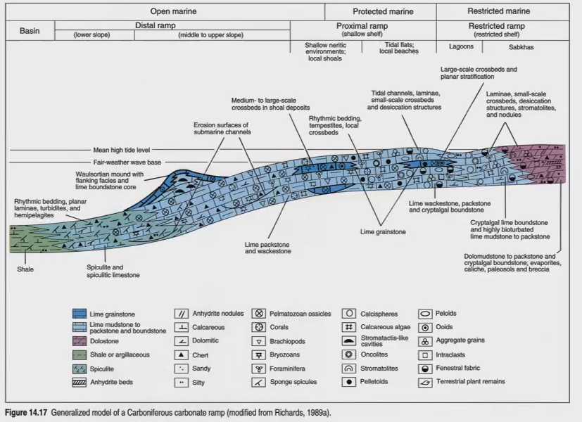
Carbonate Ramp:
Slight angle and slightly continuous (gently sloped).
Not the same as a carbonate platform.

Carbonate Platform
A ramp + a platform.
Developed during deposition of the Rundle Group.
Occupied the cratonic portion of the basin.
Supported abundant carbonate-producing organisms.
Hosted diverse marine ecosystems.
Produced many fossil-rich limestones.
Represented shallow marine depositional environments.
Difference Between Carbonate Ramp and Carbonate Platform
Carbonate ramps have a gentle, continuously sloping profile.
Carbonate platforms possess a broad, relatively flat platform surface.
Platforms are commonly associated with a distinct platform margin.
The Mississippian Rundle Group was deposited on a carbonate platform.
Common Carbonate Platform Organisms
Corals.
Brachiopods.
Bryozoans.
Crinoids.
Foraminifera.
Ooid-producing environments.
Prophet Trough:
Used to be the West Alberta Ridge.
Peace River Embayment
Formed through collapse of the former Peace River Arch.
Became a major depositional low.
Provided accommodation space for sediment accumulation.
Hosted deposition of the Mattson Group.
Presence of thick Mattson deposits confirms the arch had subsided.
Evidence for Collapse of the Peace River Arch
Mattson Group sediments accumulated directly where the arch previously existed.
Thick sediment accumulation requires accommodation space.
Essentially, it must have sunk.
An emergent island would not preserve thick basin-fill deposits.
Thickness patterns demonstrate significant subsidence occurred.
Horsts and Grabens
Horsts are uplifted fault blocks.
Grabens are down-dropped fault blocks.
Carboniferous faulting produced numerous horst and graben structures.
These structures influenced later sedimentation patterns.
Turbidites and other sediments preferentially accumulated within grabens.
Important Fault Systems
Fort St. John Graben is a major structural feature.
Numerous mapped faults define the margins of grabens and horsts.
These structures remained important throughout later geological periods.
Fault-controlled lows influenced Triassic and younger sedimentation.
Exshaw/ Bakken Formation
This formation spans the Devonian/Miss boundary transgression, rich in organic carbon; also high in U, therefore an excellent gamma ray radioactivity log marker.
Laterally continuous.
Equivalent to the Bakken Formation.
Straddles the Devonian–Mississippian boundary.
Represents a major marine transgression.
Rich in organic matter.
Characteristically black in colour.
Contains elevated uranium concentrations.
Produces strong gamma-ray log responses.
Easily recognized and correlated across large regions.
Highly laterally continuous.

Banff/Lodgepole Formation
In the Rockies, comprises a classic slope-former between the Palliser Formation (Devonian, below) and Rundle Group (Miss, above cliff formers).
It is mostly carbonates with much clastic material.
Lies above the Exshaw Formation.
Forms the transition between the Devonian Palliser Formation and the Rundle Group.
Consists primarily of carbonate rocks.
Includes some clastic sediments depending on location.
Acts as a slope-forming unit.
Thickness and lithology vary across the basin.
Becomes more clastic-rich toward the northwest.
Becomes more carbonate-rich toward the southeast.
Banff is the connecting group between the Rundle and the Palliser.
Rundle Group
Overlies the Banff Formation.
Represents development of the Mississippian carbonate platform.
Forms prominent cliffs throughout the Rocky Mountains.
Contains abundant fossils.
Includes units such as the Pekisko, Shunda, Turner Valley, and Debolt formations.
Rich fossil assemblages make it one of the most recognizable Mississippian units.
Common Rundle Group Fossils
Crinoids.
Bryozoans.
Brachiopods.
Corals.
Foraminifera.

Crinoids
Marine echinoderms commonly called sea lilies.
Possessed stalks composed of stacked disc-shaped ossicles.
Individual ossicles commonly resemble donuts with central holes.
Stalks often disarticulated after death.
Crinoidal limestones contain large accumulations of isolated ossicles.
Complete stems and crowns are occasionally preserved.
Comes in various different shapes.

Bryozoans
Colonial filter-feeding organisms.
Constructed branching or fan-shaped colonies.
Colonies housed numerous individual zooids.
Common components of Mississippian carbonate communities.
Rundle Group/Mission Canyon Formation:
In the Rockies, comprises the classic upper cliff-former of the Front Ranges; also includes the reservoir unit for the Turner Valley field SW of Calgary.
Evaporites, mostly salt, are found.

Chert in the Rundle Group
Large chert deposits occur within some Rundle Group units.
Chert = amorphous quartz.
Chert forms from silica-rich ooze.
Silica may originate from organisms such as sponges and other silica-producing organisms.
Lithified silica ooze becomes chert.
Flows along the bottom of the ocean.
Chert consists of microcrystalline or amorphous quartz.
Extremely hard and commonly used historically as flint.
Conglomerates within the Rundle Group
Some Rundle units contain conglomerates.
Conglomerates contain transported dolomite clasts.
Conglomerate of dolomite clasts in quartz sandstone matrix.
Clasts may be supported by a quartz sandstone matrix.
These deposits indicate episodes of erosion and sediment transport.
Field Localities
Mount Rundle exposes the Palliser Formation, Banff Formation, and Rundle Group.
Turtle Mountain contains fossil-rich Mississippian strata.
Where Frank slide occurred.
Crow's Nest Pass provides excellent Mississippian exposures.
Overlander Trail near Jasper exposes fossil-rich Pekisko Formation rocks.
Moose Mountain contains well-exposed Banff and Rundle strata.
Fossils are abundant at many of these locations.

ANS: B