Comprehensive Oceanography Study Guide: History, Geological Processes, Marine Sediments, and Coastal Dynamics
Fundamentals of Oceanography
Definition and Scope of Oceanography:
- Oceanography is the scientific study of the ocean, its surroundings, and the life within it.
- It operates as an interdisciplinary science integrating geology, physics, chemistry, and biology.
- Distinction from Marine Biology: Marine biology is specifically focused on marine organisms—their anatomy, physiology, and behavior. Oceanography encompasses these biological elements within the broader physical, chemical, and geological dynamics of the marine environment.
Sub-Disciplines of Oceanography:
- Geological Oceanography: Examines the structure, formation, and evolution of ocean basins, rock properties (such as paleomagnetism), seismic activity, and the origin, transport, and deposition of marine sediments.
- Physical Oceanography: Focuses on physical processes within the ocean, including wave generation (wind waves, swell waves, tsunamis), ocean currents, air-sea interaction, tropical cyclone dynamics, tidal forces, intertidal zonation, and the global conveyor-belt thermohaline circulation.
- Chemical Oceanography: Investigates the elemental composition of seawater, chemical cycles, processes controlling chemical variations, essential macronutrients, and marine pollution.
- Biological Oceanography: Studies marine organisms in relation to their physical and chemical environments, food webs, and ecological dynamics.
- Ocean Engineering: Focuses on the design, construction, and deployment of oceanographic equipment, submersibles, and monitoring instrumentation.
- Satellite Oceanography: Uses orbital remote sensing technology to monitor large-scale oceanic phenomena, sea surface temperature, currents, and topography.

- Global Ocean Metrics and Geography:
- Pacific Ocean:
- Surface Area: ().
- Average Depth: ().
- Deepest Feature: Mariana Trench at ().
- Atlantic Ocean:
- Surface Area: ().
- Average Depth: ().
- Deepest Feature: Puerto Rico Trench at ().
- Indian Ocean:
- Surface Area: ().
- Average Depth: ().
- Southern Ocean:
- Surface Area: ().
- Average Depth: Range of ().
- Arctic Ocean:
- Surface Area: ().
- Average Depth: ().
- Pacific Ocean:

- Physical Properties of Seawater:
- Seawater consists of a liquid matrix containing dissolved salts, organic compounds, and gases.
- Water density equation: .
- Solid Water (Ice): Forms an organized crystalline hexagonal matrix held by hydrogen bonds. Water expands upon freezing; as volume increases, density decreases, causing ice to float.
- Liquid Water: Hydrogen bonds continuously break and reform, creating liquid polymer chains.
- Gaseous Water: Water molecules gain enough kinetic energy to break all hydrogen bonds, dispersing freely into the gas phase.

Essential Seawater Macronutrients:
- Biological processes require high concentrations of essential macronutrients: Oxygen (), Carbon (), Nitrogen (), Hydrogen (), Phosphorus (), Sulfur (), Potassium (), Magnesium (), and Calcium ().
Biological Adaptations in the Pelagic Realm:
- Nekton: Free-swimming aquatic organisms capable of moving independently of water currents (e.g., adult fish, squids, marine mammals, and reptiles).
- Camouflage and Countershading: Dark coloration on dorsal surfaces combined with light coloration on ventral surfaces masks organisms against dark deep waters from above and light surface waters from below.
- Schooling Behaviors: Provides safety in numbers, creates the appearance of a singular large organism to deter predators, and creates coordinated evasive maneuvers to confuse attackers.
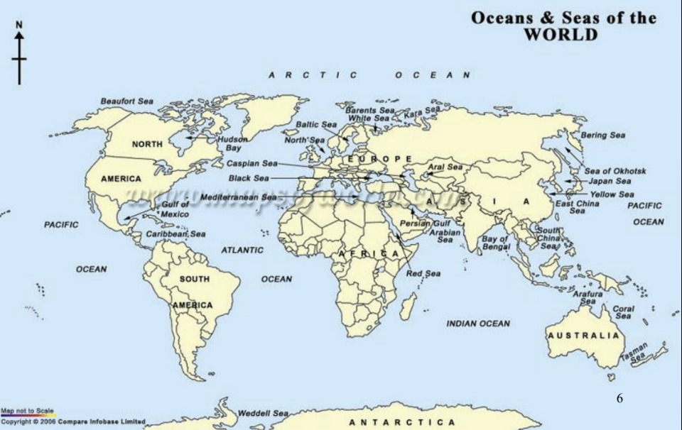
Geographical Distinction Between Oceans and Seas:
- Oceans: Massive, deep, open expanses of saltwater covering major portions of Earth's crust.
- Seas: Smaller bodies of saltwater, typically shallower, situated where land and ocean meet, and generally bounded or partially enclosed by land masses.
- The Sargasso Sea Exception: The Sargasso Sea in the North Atlantic is the only sea on Earth that lacks a terrestrial land boundary; it is defined entirely by surrounding ocean currents and floating Sargassum seaweed.
- Key Regional Seas of the Philippines: West Philippine Sea, Philippine Sea, Sulu Sea, Celebes Sea, Sibuyan Sea, Samar Sea, Visayan Sea, Camotes Sea, and Bohol Sea.
Historical Evolution of Ocean Exploration
- Ancient Maritime Explorers (1500 BC – 500 AD):
- Driven primarily by trade, territorial expansion, and food gathering.
- Egyptians: Pioneer shipbuilders who developed coastal piloting techniques.
- Phoenicians (2000 BC – 600 BC): Skilled navigators along the coasts of Egypt, Syria, Lebanon, and Israel. Navigated the Mediterranean Sea, Red Sea, and Indian Ocean, trading as far north as Great Britain. Circumnavigated the African continent around . Navigation relied on keeping visual contact with shorelines.

- Polynesian Oceanic Navigators (2500 BC – 800 AD):
- Colonized the Pacific ocean triangle, including Hawaii, Tahiti, Easter Island, Samoa, Tonga, Fiji, Tuvalu, Kiribati, Palau, and New Zealand.
- Utilized double-hulled voyaging canoes to navigate open oceans.
- Navigated without magnetic instruments, reading star paths, positions of the sun and moon, cloud formations, bird flights, species of marine life, and ocean wave dynamics.
- Constructed Stick Charts: Bamboo and wooden lattice frameworks where tied shells represented islands, and bent wooden strips mapped ocean wave swells deflected by island shorelines.


- Viking Explorations (800 AD – 1000 AD):
- First European transoceanic explorers, navigating the North Atlantic.
- Established colonies in Iceland (), Greenland (), and Vinland in Newfoundland, North America () led by Erik the Red, Bjarni Herjolfsson, and Leif Eriksson.
- Determined position by observing floating seaweed, sea bird species, whale presence, and using navigational tools:
- Sundial: Utilized the gnomon shadow from the sun to check latitude.
- Sun Stone: Crystals (calcite/Iceland spar) that polarized light, locating the sun's exact position on overcast or foggy days.

Classical Greek Science and Alexandria:
- Greeks were the first Mediterranean sailors to venture past the Strait of Gibraltar into the open Atlantic Ocean, observing boundary currents.
- Library of Alexandria: Center for early systematic scientific studies of the Earth and ocean.
- Eratosthenes: Chief librarian at Alexandria who calculated Earth's circumference to be approximately using shadow angles at Syene and Alexandria.
The Age of Discovery (1400s – 1800s):
- Motivated by European expansion, trade routes, and resource acquisition.
- Bartholomeu Dias (1487): Portuguese explorer who rounded the Cape of Good Hope, becoming the first European to enter the Indian Ocean from the Atlantic.
- Vasco da Gama (1498): Extended Dias's route around Africa, mapping the sea passage to India.
- Christopher Columbus (1451–1506): Made four transatlantic voyages starting in , seeking a western route to Asia and encountering the Americas.
- Vasco Núñez de Balboa (1513): Spanish explorer who crossed the Isthmus of Panama and sighted the Pacific Ocean.
- Ferdinand Magellan and Juan Sebastián Elcano (1519–1522): Led the first expedition to circumnavigate the globe. Magellan departed Spain in with ships and men, logging . Magellan was killed in the Philippines in . Juan Sebastián Elcano assumed command, guiding the sole surviving ship, the Victoria, back to Spain with surviving crew members after a voyage.

Scientific and Navigational Advancements (1700s–1800s):
- John Harrison (1728): Invented the mechanical Marine Chronometer, a spring-driven clock unaffected by ship motion, enabling accurate calculation of longitude at sea by comparing local solar time to Greenwich Mean Time (e.g., Manila coordinates at , ).
- James Cook (1728–1779): Led three major scientific voyages aboard HMS Endeavour, Resolution, and Adventure. Charted the South Pacific, New Zealand, eastern Australia, and the Pacific Northwest. Prevented scurvy by enforcing dietary consumption of Vitamin C. Killed in Hawaii in .
- Benjamin Franklin and Tim Folger (1769): Mapped the Gulf Stream current to optimize mail packet delivery times between North America and Europe.
- Alexander von Humboldt (early 1800s): Quantified physical ocean properties and ocean-atmosphere interactions.
- Matthew Fontaine Maury (1842/1847): U.S. Navy Officer known as the "Father of Physical Oceanography." Systematically compiled logbooks to create the first global bathymetric, wind, and current charts of the North Atlantic.
- Charles Darwin (1831): Served as naturalist aboard HMS Beagle. Formulated the subsidence theory of coral reef atoll formation (fringing reef to barrier reef to atoll) and collected bio-geographical data on finch beak variations in the Galapagos Islands that informed his theory of evolution by natural selection.
The HMS Challenger Expedition (1872–1876):
- The first oceanographic voyage devoted entirely to science.
- A refitted British corvette warship led by naturalist Charles Wyville Thomson and geologist John Murray, equipped with onboard chemical and biological laboratories, winches, and depth-sounding gear.
- Logged across all oceans, crossing the Antarctic Circle.
- Established deep-sea sounding stations, discovering the Mid-Atlantic Ridge and the Mariana Trench (recording a depth of or at Challenger Deep).
- Chemist William Dittmar analyzed seawater samples, confirming the Principle of Constant Proportions (the major ion ratios in seawater remain constant regardless of overall salinity).
- John Murray edited and authored the resulting Challenger Report over years, laying the foundation for modern geological oceanography.


Late 19th and Early 20th Century Pioneers:
- International expeditions: Norway (Vøringen, ), Germany (SS Pomerania and Crache), France (Travailleur and Talisman), Austria (Pola), USA (US Enterprise), Italy, and Russia.
- Victor Hensen: Coined the term plankton and pioneered quantitative plankton sampling.
- Alexander Agassiz: Advanced coral reef ecology and deep-sea dredging aboard the Albatross.
- Fridtjof Nansen: Intentionally froze his ship, the Fram, into Arctic ice to prove transpolar drift.
- Walfrid Ekman: Scandinavian physicist who mathematically explained wind-driven ocean current deflection and boundary dynamics (Ekman spiral).
- Polar Expeditions: Robert Peary reached the North Pole (); Roald Amundsen reached the South Pole ().
Modern Oceanographic Platforms (1900s–Present):
- German Meteor Expedition (1925): First to use acoustic echo sounders to continuously map seafloor topography across the South Atlantic.
- Ocean Drilling Programs: Deep Sea Drilling Project (DSDP, ) using the Glomar Challenger, followed by the Ocean Drilling Program (ODP) using JOIDES Resolution and Japan's Chikyu. Retrieved sediment cores proving seafloor spreading, continental drift, and that ocean crust is younger than .
- FLIP (Floating Instrument Platform): A research platform engineered to flip 90\text{^\text{o}} vertically in deep water to provide a stable, motionless platform for acoustic and wave research.
- Deep Submergence Vehicles (DSVs):
- Trieste (): Swiss-designed bathyscaphe operated by Jacques Piccard and Don Walsh that dived to the bottom of Challenger Deep.
- Alvin ( depth limit): Manned DSV responsible for discovering deep-sea hydrothermal vents and recovering a lost hydrogen bomb.
- Sea Cliff II ( depth limit).
- ROVs (Remotely Operated Vehicles): Tethered robotic vehicles such as Jason and Medea.
- SCUBA (1943): Self-Contained Underwater Breathing Apparatus developed by Jacques-Yves Cousteau and Émile Gagnon.
- Robert Ballard: Navy officer and researcher who discovered hydrothermal vents, the wreck of the RMS Titanic, the German battleship Bismarck, lost warships from the Battle of Guadalcanal, the aircraft carrier USS Yorktown, HMHS Britannic, and Lusitania.
- Satellite Remote Sensing: SEASAT (), TOPEX/Poseidon (), GOES-16, and the Jason satellite series (Jason-1, OSTM/Jason-2). Radar altimeters emit electromagnetic pulses to measure sea-surface height variations within accuracy, revealing global ocean currents, heat content, and underwater bathymetric structures.
Earth Structure and the Unifying Theory of Plate Tectonics
- Earth's Internal Layering:
- Compositional (Chemical) Layers:
- Continental Crust: Granitic composition; average thickness ; low density; dominated by Silicon () and Aluminum ().
- Oceanic Crust: Basaltic composition; average thickness ; dense; dominated by Silicon () and Magnesium ().
- Mantle: Silicate rock layer rich in Iron () and Magnesium ().
- Core: Metallic sphere composed predominantly of Iron (), Nickel (), and Sulfur ().
- Mechanical (Physical) Layers:
- Lithosphere: Rigid, brittle outer shell comprising the crust and uppermost mantle ( depth).
- Asthenosphere: Plastic, ductile layer of the upper mantle ( depth) capable of slow convective flow.
- Mesosphere: Solid lower mantle extending to the core boundary.
- Outer Core: Liquid metallic layer whose convection generates Earth's magnetic field.
- Inner Core: Dense solid metallic sphere due to extreme pressure.
- Compositional (Chemical) Layers:

- Historical Development of Tectonic Concepts:
- Abraham Ortelius (1596): Noted matching coastlines of the Americas, Europe, and Africa, suggesting tear by floods and earthquakes.
- Antonio Snider-Pellegrini (1858): Mapped identical fossil flora in European and North American coal deposits.
- Roberto Mantovani (1889): Proposed thermal expansion broke a single landmass apart.
- John Perry (1895): Demonstrated Earth's interior is fluid, proposing Earth's age far exceeded .
- Frank Taylor (1908): Proposed "continental creep" pushed landmasses toward the equator via tidal and gravitational forces.
- Alfred Wegener (1912) – Continental Drift Theory: Proposed all continents were once joined in a supercontinent named Pangaea surrounding a global ocean named Panthalassa. Wegener posited that continents plowed through stationary ocean floors.
- Evidences for Continental Drift: Geometrical jigsaw fit of continental shelves (confirmed by Sir Edward Bullard's computer model at depth contour); identical fossil distributions across oceans (Mesosaurus, Glossopteris); matching mountain belts (Appalachians in North America aligned with the Caledonian mountains in Scotland); paleoclimate anomalies (glacial till in tropical Africa/India and coal seams in Antarctica).
- The Missing Mechanism: Wegener could not explain how solid continental blocks could move through rigid oceanic crust; his proposed mechanisms (tidal forces and Earth centrifugal forces) were proven mathematically inadequate.
- Arthur Holmes (1929): Proposed mantle convection currents powered by radioactive decay as the thermal drive mechanism.
- Patrick Blackett (1950): Utilized paleomagnetism to show continents had shifted relative to Earth's magnetic poles over time.
- Harry Hess (1960/1962) – Seafloor Spreading: Proposed new oceanic lithosphere forms at Mid-Ocean Ridges (MORs) via upwelling magma and spreads laterally like a conveyor belt, sinking into deep ocean trenches at subduction zones.
- Vine-Matthews-Morley Hypothesis (1963): Confirmed seafloor spreading by analyzing magnetic anomaly stripes preserved in magnetite minerals on ocean floors. Earth's magnetic field reversals ( reversals recorded over the past , occurring roughly every ) produce symmetrical, mirror-image magnetic bands on either side of MOR axes.
- John Tuzo Wilson (1963) – Plate Tectonic Theory: Integrated continental drift, seafloor spreading, and transform faults into a unifying model. Lithospheric plates float on the asthenosphere, moving relative to one another. Driven by slab pull (dense subducting plate weight pulling the trailing plate), ridge push (gravitational sliding off elevated ridge crests), and mantle convection plumes.

Geologic Timeline of Planetary Reconstructions:
- : Continental collision and rift cycles begin regulating Earth's ocean, atmosphere, and carbon cycles.
- : Neoproterozoic supercontinent Pannotia rifts apart.
- (Ordovician): Landmasses drift north into Laurentia, Baltica, and Siberia; shallow seas support the Cambrian explosion of mineralized exoskeletons.
- (Carboniferous): Collision of Laurentia and Baltica forms Pangaea; collision uplifts the Appalachian and Caledonian mountains; triggers a major ice age.
- (Permo-Triassic): Permian-Triassic Mass Extinction ("The Great Dying"). Massive volcanic degassing released high levels of and , driving global warming, ocean acidification, and marine anoxia.
- (Cretaceous): The South Atlantic Ocean opens; India drifts northward toward Asia; Antarctica and Australia remain near the South Pole.
- (K-T Boundary): Bolide impact combined with Deccan Traps volcanism causes mass extinction of \thicksim 80 proposed \text{%} of animal species.
- : India collides with Asia, uplifting the Himalayas; Africa collides with Europe, uplifting the Alps.
- (Miocene): Modern planetary configuration emerges; elevated sea levels submerge Florida and large regions of Southeast Asia.
- : Last Glacial Maximum; continental ice sheets lower sea level, carving out the Great Lakes.
Plate Boundaries and Geological Processes:
- Divergent Boundaries: Plates pull apart under tensional forces. Magma upwells to construct new oceanic lithosphere, causing crustal thinning, shallow earthquakes, and linear rift valleys.
- Generates of new ocean floor globally per year.
- Fast Spreading: East Pacific Rise (); gentle, smooth bathymetric profiles.
- Slow Spreading: Mid-Atlantic Ridge (); steep, rugged slopes containing deep central rift valleys.
- Rifting Stages: Continental rift valley linear sea (e.g., Red Sea, Gulf of California) mature open ocean basin.
- Convergent Boundaries: Plates collide, destroying lithosphere via subduction or crustal shortening, accompanied by deep earthquakes.
- Oceanic-Continental Convergence: Dense oceanic plate subducts beneath buoyant continental plate, forming a deep ocean trench and a continental volcanic arc (e.g., Nazca plate subducting under South America, forming the Peru-Chile Trench and Andes Mountains).
- Oceanic-Oceanic Convergence: Older, colder, denser oceanic plate subducts beneath younger oceanic plate, forming a trench and an island volcanic arc (e.g., Mariana Trench and Mariana Islands).
- Continental-Continental Convergence: Buoyant continental masses resist subduction, colliding to uplift massive mountain ranges (e.g., Himalayas).
- Transform Boundaries: Plates slide past each other along strike-slip faults without producing or destroying lithosphere, producing frequent, shallow, high-intensity earthquakes (e.g., San Andreas Fault).
- Hotspots: Mantle plumes originating near the core-mantle boundary project stationary plumes of magma up through moving lithospheric plates, forming linear chains of progressive volcanic islands and seamounts (e.g., Hawaiian Islands–Emperor Seamount Chain extending ; Kauai is the oldest island, Hawaii is active, and Loihi is a submerged seamount projected to surface in ).
- Divergent Boundaries: Plates pull apart under tensional forces. Magma upwells to construct new oceanic lithosphere, causing crustal thinning, shallow earthquakes, and linear rift valleys.
Bathymetry and Seafloor Surveying Technologies
Bathymetric Measurement Overview:
- Bathymetry (, ) refers to mapping the underwater topography of ocean floors.
- Historical Soundings: First recorded measurement by Posidonius in the Mediterranean Sea () using a weighted hemp line.
- Traditional Depth Unit: Fathom ().
Acoustic Surveying Systems:
- Echo Sounding Principle: Transducers transmit conical beams of acoustic waves down through the water column. The sound pulse reflects off the seafloor and returns to a receiver.
- Depth Calculation Formula: where the nominal speed of sound in seawater , and is the recorded two-way travel time.
- Collects Bathymetry (depth via travel time) and Backscatter (acoustic signal intensity returned, indicating seafloor substrate hardness or presence of organisms).

Evolution of Sounding Technology:
- Precision Depth Recorder (PDR, 1950s): Utilized high-frequency focused sound beams with resolution, providing data used to produce the first global bathymetric maps confirming seafloor spreading.
- Multibeam Echo Sounders (e.g., Seabeam): Hull-mounted systems transmitting fan-shaped arrays of multiple sound frequencies simultaneously, mapping high-resolution swaths of seafloor up to wide.
- Side Scan SONAR (Sound Navigation and Ranging): Towed instrument packages emitting high-frequency acoustic beams outward to both sides of the tow-fish, rendering acoustic imagery of seafloor structures.
- GLORIA (1965–1993): Geological Long-Range Inclined Acoustical Asdic, developed for long-range seafloor mapping. Images display a central unmapped stripe known as the nadir zone, located directly beneath the transducer where the fan-shaped acoustic beam cannot register returns.
- Sea MARC: Sea Mapping and Remote Characterization system.
- Grade Variants: Commercial research-grade side scan sonar (e.g., CMax) vs recreational-grade systems (e.g., Hummingbird).
Satellite Altimetry and Bathymetric Inferences:
- Satellites (e.g., GOES-16, TOPEX/Poseidon, Jason series) utilize radar altimeters to measure precise sea-surface topography profiles.
- Massive subsea features (seamounts, ridges) exert local gravitational attraction, pulling seawater toward them and creating subtle bumps on the ocean surface that mimic underlying seafloor relief. Altimeters detect these height variations down to accuracy.
Sub-Surface Seismic Reflection Profiling:
- Uses high-energy, low-frequency sound bursts (air guns, chirps, or sparks) that penetrate through marine sediment into bedrock.
- Reflects off subsurface structural boundaries, creating cross-sectional profiles of sediment layers, volcanic basement rocks, and subsea fault zones (e.g., EdgeTech 3100 SB-216S Sub-bottom Profiler).
Subsea Telecommunications Infrastructure:
- Submarine fiber-optic cables carry 99 proposed \text{%} of all international transoceanic data transmissions using laser pulses inside glass tubes, providing higher speed, larger bandwidth capacity, and lower latency than satellite networks.
- Vulnerabilities: Commercial ship anchors, subsea earthquakes, turbidity currents, and rare shark bites.

Marine Geomorphology and Ocean Provinces
Water Column (Pelagic) Zonation:
- Neritic Province: Coastal, shallow water layer overlying continental shelves.
- Oceanic Province: Open ocean environment seaward of the shelf break.
- Vertical Depth Zones:
- Epipelagic Zone (): Sunlit photic zone; sufficient solar radiation for photosynthesis.
- Mesopelagic Zone (): Twilight mesophotic zone; faint light, insufficient for primary production.
- Bathypelagic Zone (): Completely aphotic dark midnight zone; contains \thicksim 75 proposed \text{%} of total living ocean volume.
- Abyssopelagic Zone (): Abyssal waters extending over deep ocean floor plains.
- Hadopelagic Zone (): Extremely deep waters enclosed within isolated oceanic trenches.
Major Geological Ocean Provinces:
- 1. Continental Margins: Submerged outer edges of continental blocks (21 proposed \text{%} of ocean floor area).
- Continental Shelf: Broad, gently sloping ( gradient) submerged continental platform extending from shoreline to shelf break.
- Continental Shelf Break: Abrupt topographic slope change transition from shelf to slope (occurring around incline).
- Continental Slope: Steeper inclines descending toward ocean basins. Cut by steep Submarine Canyons carved out by sediment-laden gravity currents.
- Turbidity Currents and Submarine Fans: Gravity-driven slurries of sediment and water, denser than ambient seawater, flow down submarine canyons, depositing graded sediment layers known as turbidites across broad submarine fan deltas at the base of the slope.
- Continental Rise: Thick accumulation of sediment transitioning between continental crust and oceanic crust at the base of the slope, blending into abyssal plains.
- 1. Continental Margins: Submerged outer edges of continental blocks (21 proposed \text{%} of ocean floor area).
Tectonic Classification of Margins:
- Active Margins (Pacific-Type): Associated with convergent or transform plate boundaries; highly active tectonically with frequent earthquakes and volcanism; characterized by narrow continental shelves and steep slopes terminating directly in deep oceanic trenches.
- Convergent Active Margins: Oceanic crust subducting beneath continental crust (e.g., western South America along the Andes).
- Transform Active Margins: Plates sliding horizontally past one another (e.g., coastal California along the San Andreas Fault).
- Passive Margins (Atlantic-Type): Face trailing edges of diverging plates far from active plate boundaries; tectonically stable with low seismicity; feature wide continental shelves, gentle slopes, and well-developed continental rises.
- Active Margins (Pacific-Type): Associated with convergent or transform plate boundaries; highly active tectonically with frequent earthquakes and volcanism; characterized by narrow continental shelves and steep slopes terminating directly in deep oceanic trenches.

- 2. Deep Ocean Basins: Cover over 50 proposed \text{%} of Earth's surface.
- Abyssal Plains: Extremely flat, featureless depositional expanses ( depth) formed by suspension settling of fine-grained clays and planktonic tests over basaltic crust. Most extensive in the Atlantic and Indian oceans.
- Volcanic Peaks:
- Seamounts: Submerged, cone-shaped extinct underwater volcanoes rising over above the seafloor.
- Guyots (Tablemounts): Flat-topped extinct volcanic seamounts eroded level by wave action prior to ocean crust subsidence.
- Abyssal Hills: Small, well-defined underwater hills rising less than above the abyssal floor, covering over 30 proposed \text{%} of the ocean bottom.
- Volcanic Islands: Volcanic peaks whose summits breach the sea surface (e.g., Hawaii).
- Deep-Sea Trenches: Deep, linear, steep-sided depressions formed by subducting tectonic plates; mark the deepest areas of the ocean floor, primarily concentrated along the Pacific Ring of Fire.
- Volcanic Arcs: Curving chains of active volcanoes located along subduction zones.
- Continental Arc: Built on continental crust where oceanic crust subducts beneath a continent (e.g., Andes Mountains).
- Island Arc: Built on oceanic crust where oceanic crust subducts beneath adjacent oceanic crust (e.g., Aleutian Islands, Mariana Islands).

- 3. Mid-Ocean Ridges (MOR): Continuous, interconnected underwater volcanic mountain ranges traversing ocean basins, formed at divergent plate boundaries.
- Oceanic Ridges vs. Oceanic Rises:
- Oceanic Ridges (Slow-Spreading): Spread at rates of ; characterized by steep, rugged bathymetry and deep, wide central rift valleys (e.g., Mid-Atlantic Ridge).
- Oceanic Rises (Fast-Spreading): Spread at rates of ; characterized by broad, gentle slopes and narrow, indistinct central rift valleys due to rapid magma output (e.g., East Pacific Rise).
- Associated Features:
- Central Rift Valleys: Deep, down-dropped fault blocks along ridge axes.
- Fracture Zones and Transform Faults: Seismic strike-slip transform faults cross-cut MOR axes, extending laterally into seismically inactive fracture zones.
- Pillow Basalts: Smooth, rounded lobes of volcanic basalt formed when low-viscosity lava erupts underwater and quenches rapidly against cold seawater.
- Hydrothermal Vents: Fissures where seawater penetrates ocean crust, heats near magma chambers, dissolves crustal metals, and vents into the ocean column. Classified by temperature into warm-water vents () and high-temperature black/white smokers.
- Oceanic Ridges vs. Oceanic Rises:
Marine Sediments: Classification, Transport, and Analysis
Paleoceanographic Significance:
- Marine sediment layers record environmental conditions in the overlying water column, such as surface water temperatures, nutrient levels, current patterns, volcanic events, atmospheric winds, plate motions, and biological extinctions.
- K-T Boundary Marker: Boundary clays formed contain high concentrations of the rare earth metal Iridium (), recording extraterrestrial bolide impact events.
Sediment Dynamics and Particle Sizes:
- Sediment Load Categories:
- Dissolved Load: Chemical ions in solution.
- Suspended Load: Fine particles kept aloft by water turbulence.
- Bed Load: Coarse material rolling, sliding, or bouncing along the bottom.
- Wentworth Scale (Phi Scale): Classifies sediment particle diameters ( in ) into logarithmic units: \text{Phi } (\text{φ}) = -\text{log}_2(D)
- Energy and Transport Mechanics: High-energy environments (strong waves/currents) transport coarse gravels and sands; low-energy environments allow silts and fine clays to settle.
- Sediment Maturity Indicators: Prolonged abrasion and weathering increase sediment maturity, characterized by: (1) decrease in silt/clay fraction, (2) increase in grain sorting, and (3) increased rounding of individual particles.
- Hjulström Diagram: Defines the flow velocity thresholds required to erode, transport, or deposit particles of varying diameters.
- Sediment Load Categories:
Classification of Marine Sediments by Origin:
- 1. Terrigenous (Lithogenous) Sediments:
- Derived from weathering and erosion of continental landmasses and volcanic island rocks.
- Mineralogy: Dominated by non-ferromagnesian silicates (Quartz, Feldspars, Micas, Aluminosilicate clays) and ferromagnesian minerals.
- Primary Composition of Earth's Crust: Oxygen (: 46.6\thicksim\text{&percent;}), Silicon (: 27.7\thicksim\text{&percent;}), Aluminum (: 8.1\thicksim\text{&percent;}), Iron (: 5.0\thicksim\text{&percent;}), Calcium (: 3.6\thicksim\text{&percent;}), Sodium (: 2.8\thicksim\text{&percent;}), Potassium (: 2.6\thicksim\text{&percent;}), Magnesium (: 2.1\thicksim\text{&percent;}).
- 1. Terrigenous (Lithogenous) Sediments:

* *Transport Vectors:*
* *Rivers:* Primary source delivering terrigenous sediment to margins.
* *Wind (Eolian):* Delivers fine atmospheric dust blowing from desert regions (e.g., Sahara, Gobi) into remote ocean basins, forming pelagic **red clays**.
* *Glaciers:* Icebergs calving off coastal glaciers carry entrained rocks and gravel out to sea, dropping unsorted **ice-rafted debris** onto the seabed as they melt.
* *Turbidity Currents:* High-speed sediment gravity flows (e.g., the Grand Banks earthquake triggered a turbidity flow moving at that severed transatlantic telegraph cables progressively down-slope).
* **2. Biogenous Sediments:**
* Derived from skeletal hard parts (shells, teeth, bones) of marine organisms.
* Classified as Macroscopic (large vertebrate bones, shells) or Microscopic (micro-plankton shells termed **tests**).
* *Classification:* Sediment containing 
* **Carbonate Dissolution Chemistry and Depth Thresholds:**
* Cold water under high hydrostatic pressure holds higher concentrations of dissolved , turning deep water slightly acidic and dissolving . * Lysocline: The ocean depth where calcite dissolution begins to occur noticeably. * Carbonate Compensation Depth (CCD): The saturation horizon depth where the rate of calcium carbonate supply equals the rate of dissolution. Below the CCD, no calcareous oozes preserve, leaving only siliceous oozes or pelagic red clays.


* **3. Authigenic (Hydrogenous) Sediments:**
* Formed by direct chemical precipitation of dissolved minerals from seawater, driven by temperature changes, pressure variations, or hydrothermal fluid input.
* *Non-biogenous Carbonates:* Aragonite needles and oolites precipitating in warm supersaturated surface waters.
* *Phosphorites:* Crusts or nodules rich in phosphate (>30 proposed \text{% } \text{P}_2\text{O}_5) formed on high-productivity continental shelves.
* *Manganese Nodules:* Dark oceanic concretions growing extremely slowly () around a central nucleus (fish bone, shark tooth, rock). Rich in Manganese ( - steel production), Copper ( - electrical wiring), Nickel ( - stainless steel), and Cobalt ( - high-strength alloys).
* *Evaporites:* Salt deposits formed in shallow, restricted seas with high evaporation rates (e.g., Mediterranean Sea). Composed of Halite (), Anhydrite (), and Gypsum (\text{CaSO}_4 \text{·} 2\text{H}_2\text{O}).
* **4. Cosmogenous Sediments:**
* Inorganic extraterrestrial particles including micrometeorites and glassy **tektites** ejected during meteorite impact events.
- Marine Sediment Sampling Instruments:
- Dredges: Heavy net frames dragged along the bottom to grab surface rocks.
- Gravity Corer: Steel tube weighted at the top, penetrating into sediment.
- Piston Corer: Uses a internal sliding piston triggered upon sea-bottom contact, driving the hollow core barrel down to extract long sediment cores.
- Box Corer: Retrieves large, undisturbed square blocks of surface sediment.
- Rotary Drilling: Industrial drilling rigs mounted on research ships (JOIDES Resolution) to cut deep rock core samples.
- Sediment Traps: Moored funnels anchored above the seabed with automated sample collector carousels to capture settling organic particulates, measuring carbon flux for global carbon cycle models.

Coastal Dynamics and Erosion Management
- Mechanics of Coastal Erosion:
- Coastal erosion is defined as the net loss of coastal sediment, resulting in shoreline retreat (landward movement of the high-water line).
- Occurs whenever sediment removal by wave energy, longshore currents, and tidal action exceeds sediment input from rivers, cliff degradation, and biological production.
- Philippine Survey Metrics: Out of of surveyed coastline, 50 proposed \text{%} is experiencing erosion. Erosion rates are highest along siliciclastic coasts (e.g., La Union); stable or accreting shorelines occur in areas like Verde Island Passage (VIP).

- Primary Causes of Coastal Erosion:
- 1. Shifts in River Mouth Positions: Diversion of river paths starves adjacent coasts of terrigenous sediment supply. For example, the redirection of the Agno River channel in the by the US Army Corps of Engineers alleviated inland flooding but starved Labrador of sediment, causing severe erosion, while causing accretion at Lingayen.
- 2. Beach Mining and Aggregate Extraction: Commercial extraction of pebbles and magnetite sand removes natural armor from foreshores.
- Pebble Extraction: Municipal extraction rates of accounted for 87 proposed \text{%} of localized retreat.
- Magnetite Sand Mining: Magnetite is a heavy mineral that protects beaches from wave erosion. Removing magnetite sand along of La Union coast destabilized beach deposits, causing shoreline retreats of and deepening nearshore waters by ..
- 3. Degradation of Coastal Habitats: Healthy ecosystems (coral reefs, seagrass beds, and mangroves) function as natural wave attenuators, absorbing 70\text{--}90 proposed \text{%} of incoming wave energy. Degradation of coral reefs (e.g., Pamilacan Island) removes natural offshore wave buffers, shifting wave breaking directly onto shorelines and halting biogenic sediment production (foraminifera, shell fragments, corals).

*   **4. Hard Coastal Structures:** Interrupt natural **littoral transport cells** (closed sediment cycling loops containing sources, pathways, and sinks).
    *   *Solid-Based Piers/Ports:* Act as barriers to longshore drift, trapping sediment on the updrift side while starving downdrift beaches.
    *   *Groins (Groynes):* Structures extending perpendicular to shorelines designed to trap sand updrift; causes accretion updrift but severe erosion downdrift.
    *   *Seawalls:* Vertical concrete walls built parallel to the coast. Seawalls reflect incoming wave energy directly downward, scouring sand off the beach face in front of the wall and accelerating beach loss.

* **5. Sea-Level Rise (SLR) and Extreme Storm Events:**
* **Bruun Rule:** As sea level rises, the beach profile translates landward and upward proportional to SLR rates. Predicted shoreline erosion magnitude is the magnitude of vertical SLR.
* *Global Sea-Level Rise Rate:* Global mean sea level rose at 3.2 ± 0.4 proposed mm/year between .
* *Storm Surges:* High-energy wave events during typhoons rapidly scour coastal sediments, shifting sand into offshore deep sinks.
- Coastal Erosion Management Strategies:
- Establish Historical Trends: Utilize historical aerial photography, satellite shoreline tracing, and bathymetric mapping to calculate precise shoreline movement rates.
- Identify Root Triggers: Differentiate between natural causes (river channel migration, storm surges) and human activities (sand mining, seawall placement) to select suitable interventions.
- Hazard Avoidance (Easement Policies): Enforce setback regulations such as Article 51 of the Water Code of the Philippines, which prohibits permanent private structures within designated coastal zones to allow natural shoreline migration.
- Relocation: Moving infrastructure and human settlements out of high-risk erosion zones (deltas, eroding sand spits).
- Soft Engineering Measures (Preferred First Line):
- Beach Nourishment: Mechanically adding sand matching the grain size and color of native sediments to the eroding beach system. Costly and requires ongoing maintenance (e.g., South Carolina nourishment costs range between $5,000\text{--}$50,000 proposed \text{per linear foot}).
- Ecosystem Rehabilitation: Re-planting mangroves, restoring seagrass beds, and implementing coral reef protection programs to absorb wave energy and maintain biogenic sand generation.
- Regional Approach: Shoreline management must be planned across full littoral transport cells rather than piecemeal within local political or municipal boundaries.