Earth science
Earth sci notes
Earthquakes occur when energy is released inside the Earth.
This energy could come from rocks breaking or from explosions within the Earth.
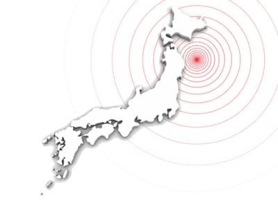
Earthquakes occur at fault lines when tectonic plates move suddenly. The exact point on the fault line where the earthquake starts is called the focus. 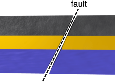 |
The point on the Earth's surface directly above the focal point of the earthquake is the epicentre.
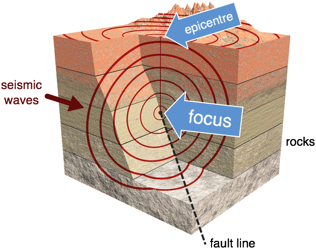
Plate boundaries have more earthquakes than the centres of plates.
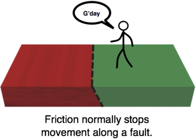
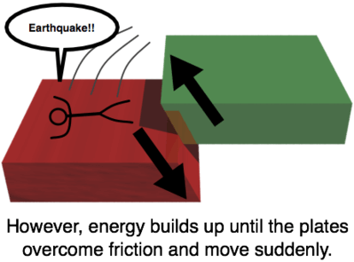
This is because friction between neighbouring plates causes energy to build up at the boundary where they meet.
When that energy is finally released, an earthquake happens.
The energy causes the ground to shake violently and even change its shape.
Energy travels through the Earth, or across its surface, as seismic waves.
Scientists use instruments called seismographs (or seismometers) to detect and record these waves. Seismic waves come in two main types: P-waves and S-waves.
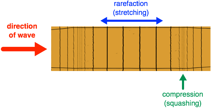
P-waves are longitudinal, like sound waves. S-waves are transverse, like waves on water. Let's have a closer look at the two types of waves.
When a P-wave passes, the particles in rocks vibrate by spreading out and squashing together in a repeating cycle.
Where the particles are spread out, it is called a rarefaction.
Where they are squashed together, it is a compression. All longitudinal waves show rarefaction and compression - including sound waves!
When an S-wave passes, the particles in rocks vibrate from side to side in a repeating cycle.
The vibration is at right angles to the direction the wave moves in.
When we draw the wave, it has high points called peaks and low points called troughs. All transverse waves show peaks and troughs - including water waves!
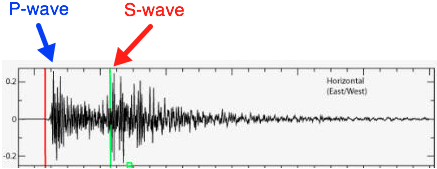
P-waves travel faster than S-waves. This means that P-waves are recorded by seismographs before the S-waves are.
Evidence of the Earth's Structure, S-waves can only travel through solids. This is how we know the Earth has a liquid outer core - S-waves can't penetrate it!
A seismogram is the output from a seismometer.
Most of the time, when the ground isn't shaking, the seismometer traces a straight line onto paper. But during an earthquake, shaking of the ground is recorded on the paper as a wiggly line. 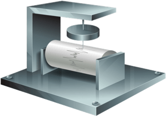 |


On seismograms, we can see when the P-waves and S-waves arrive at the seismometer. This can give us some useful info, like how far away the epicentre is!
Let's look at an example, so you can try out being a seismologist for yourself.
P-waves travel faster than S-waves, so they always reach a seismometer first. That is why they're called primary waves!
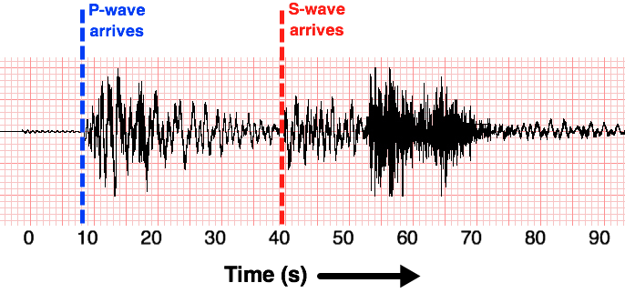
You can see when the P-wave arrives and starts the first major shake. A bit later, the S-wave (secondary wave) arrives and also leaves a trace. The seismogram shows time along the bottom, in seconds
Earth quakes
break down the key ideas for earthquakes such as what is an earthquake , and why , tectonic plates and why they shift and why it causes earthquakes and what are faults and what the types of faults are?
Sure! Here’s a breakdown of key ideas related to earthquakes:
What is an Earthquake?
An earthquake is the shaking of the Earth's surface caused by the sudden release of energy in the Earth's lithosphere. This release creates seismic waves that travel through the Earth, resulting in ground shaking.
Why Do Earthquakes Occur?
Earthquakes primarily occur due to the movement of tectonic plates. These plates are rigid segments of the Earth's crust that float on the semi-fluid asthenosphere beneath them. The movement of these plates can lead to stress accumulation and eventual failure, resulting in an earthquake.
Tectonic Plates and Why They Shift
Tectonic plates shift due to several factors:
- **Mantle Convection:** Heat from the Earth’s core causes convection currents in the mantle, driving the movement of tectonic plates.
- **Slab Pull:** Older, denser plates sink into the mantle at subduction zones, pulling the rest of the plate along.
- **Ridge Push:** At mid-ocean ridges, newly formed plates are elevated and push away from the ridge due to gravity.
Causes of Earthquakes
- **Stress Accumulation:** As tectonic plates move, they may become locked due to friction. Over time, stress builds up until it exceeds the strength of the rocks.
- **Sudden Release of Energy:** When the stress becomes too great, the rocks break or slip along faults, releasing energy as seismic waves and causing an earthquake.
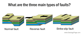
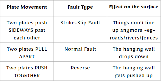
What Are Faults?
Faults are fractures in the Earth's crust where blocks of rock have moved relative to each other. They are the surfaces along which earthquakes often occur.
Types of Faults
1. **Normal Faults:** Occur when the crust is extended. The hanging wall moves down relative to the footwall.
2. **Reverse (Thrust) Faults:** Occur when the crust is compressed. The hanging wall moves up relative to the footwall.
3. **Strike-Slip Faults:** Involve lateral movement where two blocks slide past each other horizontally. The movement is mainly horizontal.
Summary
Earthquakes result from the movement and interaction of tectonic plates, leading to stress buildup and sudden release along faults. Understanding these concepts helps in comprehending the nature and causes of seismic activity.
Friction between tectonic plates builds up and the pressure is released as an earthquake.
Earthquakes are a release of energy
Earthquake damage decreases further away from the earthquake-as energy is lost
• focus is source of an earthquake
• epicentre is the point directly above the source of the earthquake on the surface.
• Describe fault types: transform fault=Slip strike, reverse and normal.
Final Exam revision (Key achieved ideas)- There are THREE questions, one on each of Earthquakes, Volcanoes and Tsunamis. Use the context/location given in your answer. The key ideas are the same for the last 8 years of papers-learn them!
Earthquake question
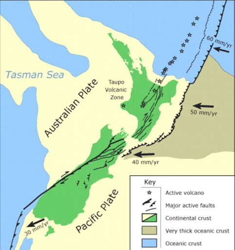
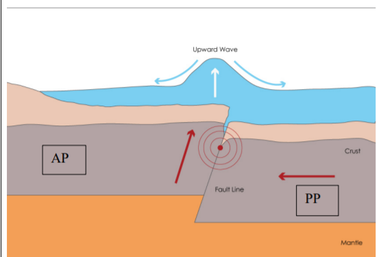
• Pacific plate subducts under the Australian plate (EXCEPTION at Puysegur Trench in south of Sth Island it's the reverse where Australian subducts under Pacific plate-see picture below)
• The Pacific Plate is (oceanic/dense) and the Australian Plate is (continental/less dense).
• The Pacific plate is made out of basalt.
• Friction between tectonic plates builds up and the pressure is released as an earthquake.
• describe earthquake as a release of energy
• earthquake damage decreases further away from the earthquake
• focus is source of an earthquake
• epicentre is the point directly above the source of the earthquake on the surface.
• Describe fault types: transform fault (Alpine)=Slip strike, reverse and normal.
• Damage on the surface structures depends on underlying soil, water content and rock OR the quality / build of the structure.
• Pacific Plate subducting (going under) puts the Australian Plate under stress, causing fractures / stress / earthquakes / uplift.
• Compression (pushing together) of crust generates ruptures / faults and the Earthquakes will be shallow with a long time / interval between events.(Alpine fault)
Tsunamis
Describe what a tsunami is (a displacement of water) and how it can be triggered by a landslide, or by an earthquake.
• Describes what a landslide is.• Describes water displacement.
.• Landslide movement causes water to be displaced.
• how a submarine (underwater) landslide could lead to a tsunami
• how a seafloor earthquake could lead to a tsunami
• tsunami carries energy which leads to a wave
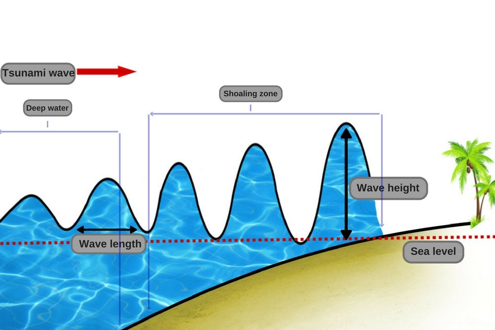
• waves increase in height / smaller wavelength (they arrive more often) as they approach land/Waves slow due to friction
• waves low in height / larger wavelength (they arrive more slowly in the deep ocean/Wave travel fast
• Monitoring tsunamis in the Pacific is difficult because of the wave height being small and frequency (wavelength) being long (far away from land-see diagram below), so they are hard to see/detect.
• summit-to-valley-floor (big drop) landslides will generate a lot of material and energy
• amount of material in the landslide is proportional to the water displaced (compare dropping a brick vs pebble)
• Uplift of the sea floor / reverse fault will generate displacement of water above. Pushes lots of water up
• Narrow width of canyon like the Cook Strait means little or no opportunity for water displacement / energy to be lost
Certainly! Here’s a breakdown of what a tsunami is, how it can be triggered, and how we measure and understand its behaviour as it moves from ocean to land.
### What is a Tsunami?
A tsunami is a series of large ocean waves typically caused by significant disturbances in or near a body of water. These disturbances can lead to the displacement of water, generating waves that can travel across entire ocean basins.
### How Tsunamis are Triggered
1. **Earthquakes:**
- **Subduction Zones:** Most tsunamis are triggered by undersea earthquakes, particularly at tectonic plate boundaries, where one plate is forced under another (subduction). This sudden vertical movement displaces a large volume of water, creating powerful waves.
- **Magnitude:** Generally, a magnitude of 7.0 or greater is needed to generate a tsunami.
2. **Landslides:**
- **Underwater Landslides:** A landslide occurring on the ocean floor can displace water, creating tsunamis.
- **Above-water Landslides:** Landslides that occur near coastlines can also generate tsunamis if the falling debris displaces enough water.
3. **Volcanic Eruptions:** Explosive volcanic eruptions, especially those that cause significant land displacement or trigger underwater explosions, can also create tsunamis.
4. **Meteorite Impacts:** Although rare, large meteorite impacts in oceans can displace water and generate tsunamis.
### Measuring Tsunamis
1. **Tsunami Buoys:**
- **DART System:** The Deep-ocean Assessment and Reporting of Tsunamis (DART) system uses buoys equipped with sensors to detect changes in water pressure, allowing for real-time monitoring of tsunami waves in deep water.
2. **Tide Gauges:**
- Used along coastlines to measure the height and arrival time of tsunami waves as they approach land. This data helps in assessing the tsunami’s impact.
3. **Numerical Models:**
- Scientists use computer models to simulate tsunami generation, propagation, and inundation, which helps predict wave behaviour and potential impacts on land.
### Behaviour from Ocean to Land
- **Wave Speed:** In deep water, tsunami waves can travel at speeds over 500 mph (800 km/h), making them fast but often undetectable due to their small wave height (typically less than a foot).
- **Wave Height:** As tsunamis approach shallower coastal waters, they slow down, and the wave height increases dramatically due to wave energy being compressed. This phenomenon is known as "wave shoaling."
- **Inundation:** The waves can inundate coastal areas, causing flooding. The height of the waves can vary greatly depending on the underwater topography and coastal features.
- **Multiple Waves:** Tsunamis often consist of multiple waves, with the first wave not always being the largest. Subsequent waves can arrive minutes apart and can be more destructive.
### Summary
Tsunamis are powerful ocean waves primarily triggered by undersea earthquakes or landslides, capable of travelling vast distances. They are measured using advanced buoy systems and tide gauges, and their behaviour is characterised by rapid wave speeds in deep water, significant height increases as they approach land, and the potential for multiple damaging waves. Understanding these factors is crucial for tsunami preparedness and response.
Sure! Here’s a breakdown of the concepts related to landslides, water displacement, and their connections to tsunamis.
### What is a Landslide?
A landslide is the movement of rock, earth, or debris down a slope due to gravity. Landslides can occur on land or under the ocean (submarine landslides) and can be triggered by factors such as heavy rainfall, earthquakes, volcanic activity, or human activities.
### Water Displacement
Water displacement occurs when an object, such as a landslide, moves into a body of water, pushing the water out of the way. This can create waves or disturbances on the surface of the water.
### Landslide Movement Causes Water to be Displaced
When a landslide occurs, especially if it happens underwater or near a coastline, the mass of moving material can displace a significant volume of water. This displacement creates waves that can propagate outward, potentially leading to a tsunami.
### How a Submarine Landslide Could Lead to a Tsunami
- **Trigger:** A submarine landslide can be triggered by factors such as earthquakes, volcanic eruptions, or heavy sediment accumulation.
- **Displacement:** When the landslide occurs, it displaces a large amount of water. This rapid movement creates waves that can travel across the ocean.
- **Tsunami Formation:** If the volume of displaced water is substantial, it can generate a tsunami, which can impact coastal areas.
### How a Seafloor Earthquake Could Lead to a Tsunami
- **Sudden Movement:** A seafloor earthquake occurs when there is a sudden shift in tectonic plates along fault lines beneath the ocean.
- **Vertical Displacement:** This movement can cause the seafloor to suddenly rise or fall, displacing water above it.
- **Wave Generation:** The displaced water generates waves, leading to a tsunami that radiates outward from the epicentre of the earthquake.
### Tsunami Carries Energy Which Leads to a Wave
- **Energy Transfer:** Tsunamis carry energy through the water column. This energy is transferred to the water, creating waves that travel across the ocean.
- **Wave Characteristics:** Tsunami waves have long wavelengths and can travel at high speeds in deep water.
### Waves Increase in Height and Decrease in Wavelength as They Approach Land
- **Wave Shoaling:** As tsunami waves approach shallow coastal waters, they slow down due to friction with the seafloor, causing their wavelengths to decrease and their heights to increase.
- **Increased Frequency:** The waves arrive more frequently as they slow down, leading to potentially dangerous surges upon reaching land.
### Waves Low in Height and Larger Wavelength in Deep Ocean
- **Deep Water Characteristics:** In the deep ocean, tsunami waves have long wavelengths (up to several hundred kilometres) and relatively low heights (often less than a metre).
- **Fast Travel:** These waves can travel at speeds over 500 mph (800 km/h) without being noticed by ships or coastal observers due to their low height.
### Summary
Landslides, both on land and underwater, can displace water, leading to tsunami formation. Submarine landslides and seafloor earthquakes create significant water displacement, generating waves that carry energy across the ocean. As these waves approach land, they slow down and increase in height, becoming potentially hazardous. In contrast, in deep ocean waters, tsunami waves are fast, low, and have long wavelengths, making them difficult to detect.
Volcanos
Here’s a breakdown of hotspot formation, the types of volcanoes associated with it, and the types of eruptions:
General Idea of Hotspot Formation
- **Hotspot Definition:** A hotspot is an area in the mantle where heat rises as a thermal plume from deep within the Earth. This heat causes melting of the mantle material, creating magma that can rise to the surface, forming volcanoes.
- **Not a Plate Boundary:** Unlike most volcanic activity that occurs at tectonic plate boundaries, hotspots are located within tectonic plates. An example is the Auckland Volcanic Field (AVF) in New Zealand, where volcanic activity is not related to the interaction of tectonic plates.
Types of Volcanoes Associated with Hotspots
1. **Shield Volcanoes:**
- **Description:** These volcanoes have broad, gentle slopes and are formed by the eruption of low-viscosity basaltic lava that can flow over long distances.
- **Example:** The Hawaiian Islands are primarily composed of shield volcanoes formed by a hotspot.
2. **Stratovolcanoes (or Composite Volcanoes):**
- **Description:** These volcanoes are characterised by steeper profiles and are formed from alternating layers of lava flow, ash, and volcanic rock. They can be found where magma is more viscous.
- **Example:** Mount St. Helens in the United States is a stratovolcano.
3. **Volcanic Fields:**
- **Description:** A volcanic field is a region with numerous small volcanoes, often with various types of eruptions and formations.
- **Example:** The Auckland Volcanic Field consists of a series of volcanic cones and craters.
4. **Caldera:**
- **Description:** A caldera is a large depression formed when a volcano erupts and collapses into itself, usually after a massive explosive eruption.
- **Example:** Yellowstone Caldera is a well-known example formed by hotspot activity.
Types of Eruptions
1. **Effusive Eruptions:**
- **Description:** In effusive eruptions, magma rises through the surface and flows out as a low-viscosity liquid known as lava. These eruptions are generally characterised by low gas content, resulting in less explosive activity.
- **Typical Products:** The lava flows can create broad shield volcanoes and lava plateaus.
2. **Explosive Eruptions:**
- **Description:** These eruptions are characterised by more viscous (sticky) magma with a high gas content, which can lead to significant pressure buildup and violent eruptions.
- **Phreatomagmatic Eruptions:** These occur when magma comes into contact with water, resulting in explosive reactions due to rapid vaporisation.
- **Typical Products:** Explosive eruptions can produce ash clouds, pyroclastic flows, and volcanic bombs, often leading to the formation of stratovolcanoes.
Summary
Hotspots are areas in the mantle where magma rises to the surface, forming various types of volcanoes, such as shield volcanoes, stratovolcanoes, and calderas. Eruptions at these hotspots can be either effusive, producing low-viscosity lava flows, or explosive, involving high-viscosity magma with significant gas content. Understanding these processes helps in assessing volcanic activity and potential hazards associated with hotspot volcanism.
• Steam is created from the hot magma in contact with water.
• Scoria (made of basalt, contains gas and cooled quickly, high temp/low viscosity=runny) causes a low ring (shield) to form around the crater (AVF).
• Rate of cooling of the lava-fast cool traps gas-leaves holes like pumice and scoria.
• Less silica means the lava has low viscosity and less gas.
• Subduction under Taupo Volcanic Zone TVZ as Pacific Plate (PP) subducts and melts beneath Australian Plate (AP) due to PP being more dense than AP. Usually andesite volcanoes like Ruaphehu. The calderas are Taupo and Okataina (Rhyolitic). Heat from basalt magma melts the continental crust forming rhyolitic magma.
• Geysers are made up of groundwater heated by moving magma through a narrow opening in the crust.
• Due to the magma being sticky (high silica) it traps gas (high gas) thus a more explosive eruption.
• The alternating layers of ash and lava which produce a stratovolcano/cone.
Initial eruption / pyroclastic flow layer as a mixture of ash and gases.
• trapped gases are released explosively.(dacite/rhyolitic-see table below) MORE GAS=MORE explosive
Basaltic: forms shield volcanoes
Andesitic: forms cone shaped volcanoes
Rhyolitic: forms dome and caldera volcanoes
NZ-Kermadecs a subduction volcanic arc, the hotspot Auckland Volcanic Field, Okataina and Taupo Volcanic Zone (subduction boundary)
• trapped gases being released explosively (to produce first stage of eruption, ash, pumice or caldera formation) • (second stage) as rhyolitic lava in the form of domes and sea floor lava flows.
• Basaltic lava is low in silica / not very viscous (runny) / low in gas content / usually not explosive.(unless contacts water) • Dry eruption may form a cone of loose material / scoria cone. • Eruption may form a gentle sided / shield volcano like AVF.
• TWO characteristics of rhyolitic magma e.g.: - relatively low temperature (750–850 °C) - highly viscous - contains high quantity of trapped gases - silica rich.
Formation of caldera from magma containing a high quantity of gases / highly explosive eruption. • After a caldera eruption dome formed from degassed / viscous lava OR magma forced out by sinking crust (post eruption) or magma chamber collapse.
Magma TYPE ‘BAR’ NZ Example SHAPE LAVA Features |
Basaltic (Effusive &/or Explosive). Least Explosive type Auckland V Field (Rangitoto) Shield ( or small scoria cone) Runny (Low Viscosity) (Approx 45% Silica). Hottest, Low gas |
Andesitic (Effusive &/or Explosive) (Dacite is between Andesitic and Rhyolitic) Taranaki Cone Thick Viscous (sticky) so slower flowing, Intermediate Silica (52%+) |
Rhyolitic (Usually Explosive). Most Explosive type Tarawera/Taupo Dome/Caldera High Silica (70%+), Very viscous (stiff). Coolest high gas |