3e Soil Movement
total available water-holding capacity
accounts for all plant available water
soil properties differ between horizions
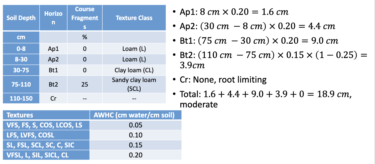
total awhc example
see slides for calculations
estimating total awhc using texture
texture is a primary factor influencing soil moisture retention
the plant available water in a horizon can be estimated as follows:
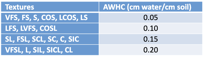
for example, if a soil horizon had a loamy, very fine sand (LVFS) texture and was 27cm thick, the awhc is
27cm soil *.10cm water/cm soil=2.7 cm water
coarse fragments are excluded from this estimate because rocks don’t hold water
if a soil horizon was 35cm thick, had 20% coarse fragments and a sandy clay structure (SC) the awhc is:
AWHC = 35cm soil x 0.15 cm water/cm soil x (1-0.20) = 4.2 cm water
when estimating total awhc you MUST:
calculate to a depth of 150 cm or depth of root limiting layer
assume the bottom horizon extends to 150 cm if the hole was only dug to a shallower depth
root limiting layers include:
r horizons
cr horizons
“water retention class” is determined as follows:

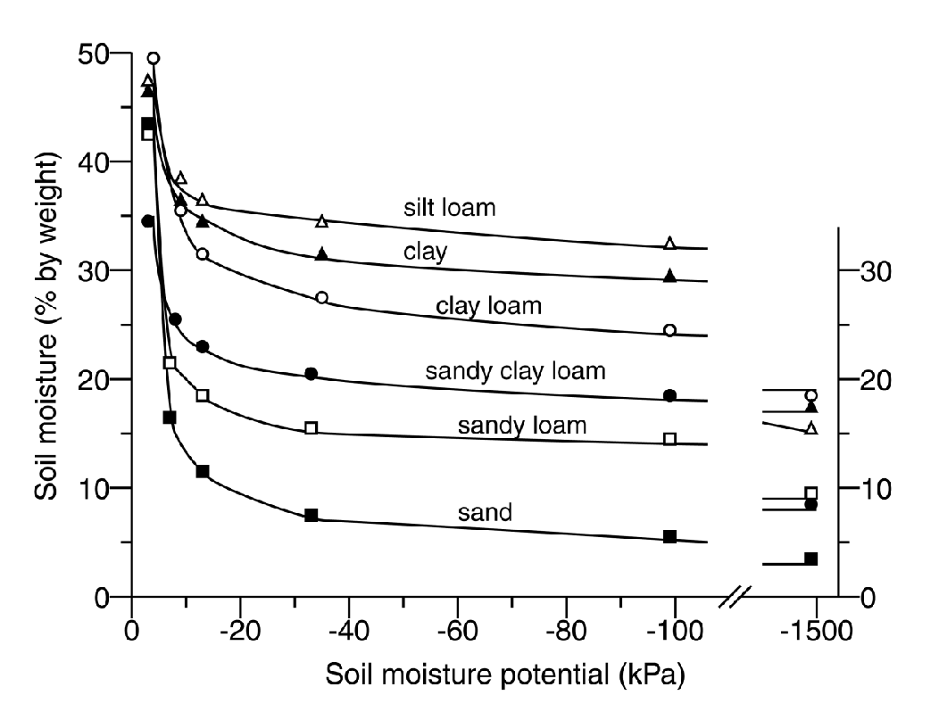
soil moisture retention curve
aka:
water content-matric potential curve
soil moisture curve
soil moisture characteristic curve
soil moisture characteristic
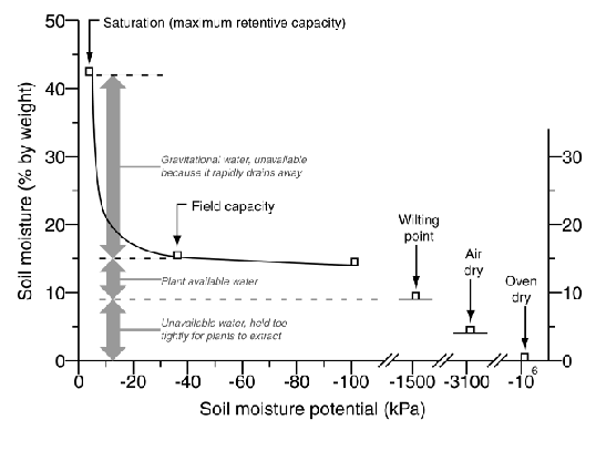
a graph depicting the relationship between soil moisture content and soil tension
soil moisture potential range
0 kpa(water table) to -106kpa (oven dry)
sometimes graphed on a log scale
sometimes graphed w a break in the axis
gravimetric method
“gold standard”
requires destructive sampling
water content = (wet weight - dry weight)/dry weight
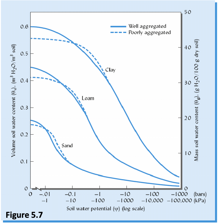
soil moisture retention curve and texture
clays:
high surface area
high porosity
most water storage
sands:
lowest surface area
lowest porosity
least water storage
loams:
in the middle
tensiometer
consists of a water filled stiff plastic tube, a porous tip, and a vacuum gauge
water is pulled out of the tensiometer and into the soil by tension
a vacuum forms in the tube equal to the tension of the soil near the tip
neutron probe
one of the more accurate moisture measurement methods
detects density of the slow neutron cloud surrounding the probe/detector
the wetter the soil, the more dense the cloud
tdr probe (time domain reflectomatry)
developed originally for sensing breaks in buried power lines
electrical pulse sent out and reflected back to sensor
time it takes depends on soil moisture