Geological and Environmental Sciences Exam Notes
Solar System Formation (Nebular Theory)
Nebula forms from hydrogen, helium, and heavier elements from stars.
Gravity pulls gas/dust inward, forming an accretionary disk.
Proto-Sun forms at the disk's center.
Dust concentrates in inner rings, ice in outer rings.
Fusion starts; the Sun ignites.
Dust and ice form planetesimals via collisions.
Planetesimals collide, forming a proto-Earth.
Gravity shapes proto-Earth into a sphere; core and mantle differentiate.
Protoplanet collision forms a debris ring.
The Moon forms from the ring.
Atmosphere develops from volcanic gases.
Oceans form from condensed moisture and comets.
Earth Formation
Protoplanetary disk.
Orbit clears.
Chunks collide into planetesimals.
Planetismals amalgamate, growing larger.
Irregular proto-Earth forms.
Interior heats, softens.
A Mars-sized protoplanet collides 4.5 billion years ago.
Debris forms a ring around Earth.
The moon forms and clears the debris orbit.
Gravity reshapes the moon into a sphere.
Early Earth
4.54 Ga (billion years old).
Extremely hot with constant volcanic eruptions.
Volcanic gases form the early atmosphere (H2O, CO2, NH4, CH4).
Tons of asteroid/protoplanet impacts until ~3.85 Ga.
Surface melts and remelts.
Impact energy separates heavy and light elements, forming core, mantle, crust, hydrosphere, and atmosphere.
Water present by 3.85 Ga, potentially from comets, chemical reactions, or volcanoes.
Earth cools; water condenses, forming oceans.
CO2 dissolves into oceans, precipitates into solids, and is trapped in the crust.
Oceans full of dissolved iron (Fe).
Atmosphere
Early atmosphere: H2O, CO2, NH4, CH4; greenish and cloudy.
No free oxygen initially.
Outgassing from Earth’s interior.
Water condenses, forming oceans.
CO2 dissolves into oceans, becomes trapped in rocks in the crust.
Modern Atmosphere
Nitrogen (N2): 78.08%
Oxygen (O2) - 20.95%
CO2 - 0.04%
O2 entered the atmosphere after photosynthesis evolved (1.8 Ga), significant O2 by 600 Ma.
Radioactive Decay Law
= decay constant
Parent = radioactive isotope (e.g., )
Daughter = stable isotope (e.g., )
Earth's oldest materials dated to 4.54 billion years (4.54 Ga).
Earth's age is constrained by measuring both Earth rocks and meteorites.
Earth's Structure (Chemistry and Physics)
Driving principles: pressure, temperature, gravity.
Based on chemistry and physics.
Crust (least dense) - Solid.
Mantle (denser) - Solid/Plastic.
Outer Core (most dense) - Liquid.
Inner Core - Solid.
Common elements: C, N, Fe, Ni, Si, O, Mg, S, Al, H, Na, Ca, K.
Crust: Major O, Si; Minor Fe, Al, Ca, Mg, Na, K, S
Mantle: Major Mg, O, Si; Minor Ca, Fe, Al
Outer Core: Fe, Ni, Minor O, S
Inner Core: Fe, Ni
Atmosphere/Biosphere: Major N, O, C, H; Minor P, S
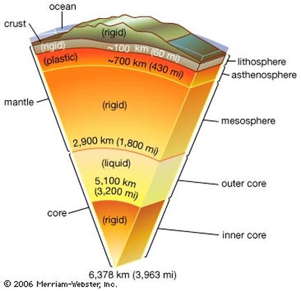
Earth's Interior - Seismic Waves
Earthquakes act like ultrasounds.
P-waves (primary, compression): fast, move through solids and liquids.
S-waves (secondary, shear): slower, move only through solids.
Reflection and refraction occur when passing through different densities.
Surface waves: Love (horizontal shearing) and Rayleigh (rolling).
Mohorovičić Discontinuity ("Moho")
Boundary between crust and mantle.
~35 km below continents, ~7 km below ocean crust.
Defined by increased seismic wave velocity.
Earth's Layers
Crust: Rigid, variable thickness and composition, 0.1-1% of Earth’s radius.
Lithospheric Mantle: Rigid, olivine, pyroxene, garnet, 35-100km depth.
Upper Mantle: Rigid, low-velocity zone (1-6% melt). Minerals change to spinel+perovskite.
Lower Mantle: Solid, minerals change to periclase + perovskite, densely packed
Outer Core: Liquid, Fe + Ni alloy.
Inner Core: Solid, Fe + Ni alloy.
Significance of Liquid Outer Core
Liquid outer core + Earth's rotation = magnetic field due to rotating spiral currents.
Results: Compass points north, Earth protected from solar wind by the magnetosphere.
Protects satellites (GPS) and electric grid.
Van Allen Belts trap charged particles.
Continental Drift (Alfred Wegener)
Continents fit together like a jigsaw puzzle.
Similar rocks, geologic structures, and fossils across the Atlantic.
Hypothesis: Continents were joined in a supercontinent ("Urkontinent" or "Pangaea").
Evidence for Continental Drift
Fit of continents (modern coastlines).
Locations of past glaciers (Paleozoic Era Ice Age = 280-260 Ma).
Climate belts.
Fossil distribution.
Matching geologic units (Pre-Cambrian rocks in S. America and Africa, Appalachian Mountains).
Paleomagnetism
Magnetic field generated by convection in the outer core and can reverse.
Magnetic declination: Angle between magnetic north and geographic north.
Magnetic signal recorded in rocks (sediments and cooled lavas).
Paleopoles: Past positions of Earth’s magnetic poles.
Magnetic anomalies: Differences between expected and measured magnetic field strength.
Bathymetry
Study of underwater topography using SONAR.
Mid-Ocean Ridge (MOR)
Submarine mountain belt at divergent oceanic plate boundary.
Sea Floor Spreading
New crust forms at mid-ocean ridges; old crust consumed elsewhere.
Spreading Rate: Atlantic = 2 cm/year, Pacific = 10 cm/year
Evidence: Sediments get older and thicker away from ridge axis, oldest oceanic crust is ~200 Ma.
Continental and Oceanic Crust
Oceanic Crust
Thinner
Denser
Low silica content ()
Continental Crust
Thicker
Less Dense
High silica content ()
Plate Tectonics
Lithosphere floats on asthenosphere (Isostasy).
Plate Boundaries
Divergent: Plates move apart, creating new crust (e.g., mid-ocean ridges, continental rifting).
Convergent: Plates move toward each other, consuming crust (e.g., subduction zones, continent-continent collisions).
Oceanic/Oceanic: One subducts; older, colder, denser plate subducts.
Continental/Oceanic: Creates volcanic arc; subducted crust melts and makes new crust with volcanic range.
Continental/Continental: collide, creates mountain ranges like Appalachians.
Transform: Plates slide past each other horizontally.
Features of Convergent Plate Boundaries
Earthquakes: Wadati-Benioff Zone.
Accretionary Prism: Sediment and rock scraped off downgoing plate.
Basins: Back-arc and fore-arc.
Trench: Deep trough bordering volcanic arc.
Transform Boundaries
Plates slide past each other, horizontal motion.
Fracture zones: Narrow bands of vertical fractures.
Special Cases
Triple Junctions: Three plates intersect.
Hot Spots: Isolated volcanoes from mantle plumes.
Margins
Active: Coincides with plate boundary (e.g., Coast of California).
Passive: Does not coincide with plate boundary (e.g., East Coast of US).
Orogeny
Mountain building, uplift, and deformation.
Deformation
Brittle: Cracking and fracturing.
Plastic: Bending and flowing.
Geologic Structures
Folds: Bends or wrinkles in rock layers (anticlines, synclines, monoclines, domes, basins, plunging folds).
Joints: Natural cracks in rocks (columnar jointing).
Faults: Fractures where rocks slide past each other (dip-slip, strike-slip, oblique-slip).
Veins: Seams of minerals in open joints.
Shearing Stress: moves one part sideways past another part
Foliation: layering formed by mineral alignment or compositional banding in metamorphic rock, differential pressure + shear stress.
Mountain Building and Plate Tectonics
Subduction zones (oceanic-continental).
Continental collisions (continent-continent).
Continental rifting.
Geologic Maps and Cross Sections
Geologic Maps: Show rock unit distribution.
Cross Sections: Depict subsurface contacts.
Strike and Dip: Measurements used to create maps and cross-sections
PART 2: MINERALS, IGNEOUS, SEDIMENTARY & METAMORPHIC ROCKS
1. Minerals
Crystal lattice: ordered atomic structure → physical properties.
Silicate groups: isolated, chain, double chain, sheet, framework.
Variable composition: solid solution series (e.g., olivine).
Mineral growth: from cooling magma, evaporation, hydrothermal activity.
Human uses: electronics (quartz), construction (calcite), pigments.
2. Igneous Rocks
Partial melting: source rock determines melt chemistry.
Fractional crystallization: mafic minerals crystallize first.
Assimilation: surrounding rock melts into magma.
Mafic lava = low viscosity (flows easily), Felsic lava = explosive.
Intrusions:
Dike: vertical.
Sill: horizontal.
Laccolith: dome-shaped.
Batholith: large, deep-rooted (e.g., Sierra Nevada).
3. Volcanism
Effusive eruptions: basaltic, low gas.
Explosive eruptions: rhyolitic, gas-rich.
Hazards: ashfall, pyroclastic flows, lahar (mudflows), gas release.
Monitoring: seismicity, gas emissions, ground deformation.
4. Sedimentary Rocks
Texture reflects transport history: well-sorted & rounded = long transport.
Lithification: compaction + cementation.
Environments:
Terrestrial: alluvial fans, rivers, deserts, lakes.
Coastal: beaches, deltas.
Marine: continental shelf, reef, deep sea.
Biochemical indicators: fossil types, shell composition.
Evaporites: form in restricted basins (e.g., halite, gypsum).
5. Metamorphic Rocks
Grades:
Low: slate, phyllite.
Medium: schist.
High: gneiss, migmatite.
Facies: mineral assemblages reflecting T/P conditions.
Tectonic settings:
Subduction zones: blueschist.
Continental collisions: high-grade regional.
Shock metamorphism: impacts (e.g., meteor craters).
PART 3: RESOURCES, GEOLOGIC TIME & RADIOACTIVE DATING
1. Energy Resources
Fossil fuels: formed in anoxic environments, buried over geologic time.
Coal: from terrestrial plant matter in swamps.
Oil: marine plankton → kerogen → crude oil.
Gas hydrates: methane in ice lattices under deep-sea sediments.
Renewable energy: solar, wind, hydro, geothermal.
Environmental effects: greenhouse gases, acid rain, habitat destruction.
2. Mineral Resources
Strategic minerals: essential for technology (REEs, lithium).
Ore enrichment:
Mechanical: panning, sluicing.
Chemical: smelting, leaching.
Sustainability: recycling, reducing use, finding alternatives.
Reclamation: restoring land after mining.
3. Geologic Time
Time units:
Eon: Phanerozoic (visible life).
Era: Paleozoic, Mesozoic, Cenozoic.
Period: Jurassic, Cretaceous, etc.
Major events:
Cambrian Explosion (~541 Ma): rise in diversity.
Permian Extinction (~252 Ma): largest mass extinction.
K-T Boundary (~66 Ma): dinosaur extinction.
Quaternary (~2.6 Ma–now): ice ages, humans.
4. Radiometric Dating
Decay chains: multiple steps from parent to stable daughter.
Closure temperature: below this, radiometric clock starts.
Concordia diagram: used in U-Pb dating to check reliability.
Dating techniques:
Fission track: tracks from spontaneous nuclear decay.
Luminescence: trapped electron release dates last exposure.
Applications: archaeology, climate change, plate motion studies.