GEOGRAPHY - Coastal Environments
Wave Action & Erosion
Coasts are the meeting point of land and sea and are an open system with inputs (sediment), transfers (longshore drift), stores (beach) and outputs (water).
Coastal processes are divided into two parts:
Marine processes: offshore (water-based)
Terrestrial processes: onshore (land-based)
These processes are then sub-divided into:
Wave action
Erosion
Transportation
Weathering
Mass movement
It is these activities that are responsible for producing distinctive landforms found on the coast
Wave Action
Waves are marine processes. They erode, transport and deposit material
Waves are formed by winds blowing over the surface of the sea
The height and strength of a wave is dependent on 3 factors:
The fetch
The amount of time the wind blows
The strength of the wind
The greater the strength, time and fetch of the wind, the larger the wave
As a wave approaches the coast and enters shallower water, friction from the sea bed causes the wave to lean forward and eventually crest and break onto the beach
The movement of water up the beach is called the swash, and the return movement is the backwash
Types of Waves
There are two types of waves:
Destructive waves erode the beach
Constructive waves are beach builders
Comparison of Wave Type
| Constructive Wave | Destructive Wave |
Swash | Strong | Weak |
Backwash | Weak | Strong |
Wavelength | Long with low height | Short with high height |
Frequency | Low (6–8 per minute) | High (10–12 per minute) |
Type of beach | Sandy: depositional | Shingle: erosional |
 Erosion
Destructive waves erode the coastline in four ways:
Hydraulic Action
Attrition
Corrosion
Abrasion
Transportation
Material arrives from:
Eroded cliffs
Longshore drift
Constructive waves
River discharge
In the water, material is moved through:
Traction
Saltation
Suspension
Solution
Longshore Drift
It is the main process of deposition and transportation along the coast
The prevailing wind pushes the waves at angle to the beach
As the waves break, the swash carries material up the beach at the same angle
As the swash retreats, the backwash carries the material down the beach at right angles (90°)
The process repeats, transporting material along the beach in a zig-zag movement

Weathering
This is the breakdown of rock in-situ. Weathering does not involve the movement of material, making it different from erosion
Sub-aerial weathering describes coastal processes that are not linked to the action of the sea
It includes:
Freeze-thaw weathering (mechanical)
Salt weathering
Weathering weakens cliffs and makes them more vulnerable to erosion
Mechanical weathering physically breaks up rock:
One example is freeze-thaw or frost shattering
Water gets into cracks and joints in the rock
When the water freezes it expands and the cracks open a little wider
Over time, pieces of rock split off the rock face, whilst big boulders are broken into smaller rocks and gravel
Chemical weathering occurs when rocks are broken down by a chemical process:
Rainwater is slightly acidic through absorbing carbon dioxide from the atmosphere
This reacts with minerals in the rock, creating new material
Rock-type affects the rate of weathering; e.g. limestone chemically weathers faster than granite
The warmer the temperature, the faster the chemical reaction
Biological weathering takes place when rocks are worn away by living organisms:
Trees and other plants can grow within the cracks in a rock formation
As the roots grow bigger, they push open cracks in the rocks, making them wider and deeper
Over time, the growing tree eventually forces the rock apart
Tiny organisms like bacteria, algae and moss can grow on rocks
These produce chemicals that break down the surface layer of the rock
Burrowing animals, such as rabbits, disturb the ground
This destabilises the rock above the burrow
Increasing pressure on any cracks
Eventually, pieces fall off the rock
Mass Movement
Mass Movement
The downhill movement of material under the influence of gravity
Throughflow and runoff caused by heavy rain can also make cliffs more unstable and increase the likelihood of mass movement
It includes landslides, slumping and rockfalls
What influences the type of movement?
The angle of slope (steeper is faster)
Nature of regolith
Amount and type of vegetation
Water
Type and structure of rock
Human activity
Climate
Types of movement
Soil Creep:
Speed is below 1cm per year
Common in humid climates
When soil expands, individual particles are lifted up at right angles to the slope
Soil also expands when it freezes, gets wet or is heated up in the sun
When the soil shrinks again, the particles fall straight back down
Soil creep takes a long time because the soil moves only a millimetre to a few centimetres at a time
Flow:
It occurs on slopes between 5° and 15°
Usually, after the soil has become saturated with a flow of water across the surface
Vegetation can be flattened and carried away with the soil
Speeds range from 1 to 15km per year
Slide:
A movement of material 'en masse' which remains together until hitting the bottom of a slope
Fall:
Slopes are steep and movement is rapid
Caused by a number of reasons:
Extreme weathering—freeze-thaw action—can loosen rocks that become unstable and collapse
Rainfall: too much rain will soften the surface, leading to the collapse of the slope
Earthquakes can dislodge unstable rocks
Hot weather can dry out soil, causing it to shrink and allowing rocks to fall
Slump:
Usually found on weaker rock types (i.e. clay) that become saturated and heavy
This is common at the coast and is also known as rotational slip
It involves a large area of land moving down the slope in one piece
Due to the nature of the slip, it leaves behind a curved surface

Erosional Landforms
Headland and bay
Found in areas of alternating bands of resistant (hard) and less resistant (soft) rocks running perpendicular to oncoming waves (discordant coastline)
Initially, less resistant rock (e.g. clay) is eroded back, forming a bay
A bay is an inlet of the sea where the land curves inwards, usually with a beach
The more resistant rock (e.g. limestone) is left protruding out to sea as a headland

Headland and bay formation
Cove
A cove forms where the coastline has bands of resistant and less resistant rock running parallel to the oncoming waves (concordant coastline)
There is usually a band of resistant rock facing the oncoming waves, with a band of softer rock behind
Wave processes of abrasion, corrosion and hydraulic action will exploit faults in the resistant rock and erode through to the softer rock
Further wave action will erode the softer rock quickly, which will leave behind a circular cove with a narrow entrance to the sea
Wave refraction within the cove spreads out the erosion in all directions, creating the typical horseshoe shape
Lulworth Cove in Dorset, UK, is a good example of a cove

The formation of coves
Cliff and wave-cut platform
Cliffs are shaped through erosion and weathering processes
Less resistant rock erodes quickly and will form sloping cliff faces
Steep cliffs are formed where there is harder rock facing the sea
A wave-cut platform is a wide gently sloped surface found at the foot of a cliff:
As the sea attacks the base of a cliff between the high and low water mark, a wave-cut notch is formed
Abrasion, corrosion and hydraulic action further extend the notch back into the cliff
The undercutting of the cliff leads to instability and collapse of the cliff
The backwash of the waves, carries away the eroded material, leaving behind a wave-cut platform
The process repeats and the cliff continues to retreat, leading to a coastal retreat

The formation of cliffs and wave-cut platforms
Cave, arch, stack and stump
Found on a headland due to wave action and sub-aerial weathering
Any weaknesses in the headland are exploited by erosional processes of hydraulic action, abrasion and corrosion
As the crack begins to widen, abrasion will begin to wear away at the forming cave
The cave will become larger and eventually break through the headland to form an arch
The base of the arch continually becomes wider and thinner through erosion below and weathering from above
Eventually, the roof of the arch collapses, leaving behind an isolated column of rock called a stack
The stack is undercut at the base by wave action and sub-aerial weathering above until it collapses to form a stump

Stack formation
Depositional Landforms
Beach
Form in sheltered areas such as bays
Deposition occurs through constructive wave movement, where the swash is stronger than the backwash
Beach formation usually occurs in the summer months when the weather is calmer
Sometimes sand from offshore bars can blow onto the shore by strong winds
Blown sand can create sand dunes at the backshore of a beach
Spit
An extended stretch of sand or shingle that extends out to sea from the shore
Spits occur when there is a change in the shape of the coastline
Or the mouth of a river, which prevents a spit from forming across the estuary
A spit may or may not have a 'hooked' end, depending on opposing winds and currents
A good example is Spurn Point, which stretches for three and a half miles across the Humber Estuary in the northeast of England
Stages of Formation:
Sediment is transported by longshore drift
Where the coastline changes direction, a shallow, sheltered area allows for deposition of sediment
Due to increased friction, more deposition occurs
Eventually, a spit slowly builds up to sea level and extends in length
If the wind changes direction, then the wave pattern alters and results in a hooked end
The area behind the spit becomes sheltered
Silts are deposited here to form salt marshes or mud flats

Spit formation
Bar
When a spit grows across a bay, and joins two headlands together
A bar of sand is formed (sandbar)
Sandbars can also form offshore due to the action of breaking waves from a beach

Bar formation
Lagoon
A lagoon is where a small body of water is cut off from the sea
A lagoon may form behind a bar or tombolo
Lagoons do not last forever and may fill with sediment and form new land
Tombolo
A tombolo is formed when a spit joins the mainland to an island
Chesil Beach in Dorset is a tombolo, as the mainland is joined to the Isle of Portland
Barrier Island
Barrier islands form parallel to the coast
The main difference between a bar and barrier island is that a bar joins two headlands, whereas a barrier island is open at one or both ends

Deposition landforms
Influence of Geology
Geology shapes the coastline over time, place and space
A coastline made up of softer rocks such as sands and clays will be easily eroded by destructive waves to form low, flat landscapes such as bays and beaches
Coastlines of more resistant, harder rock will take longer to erode and produce rugged landscapes such as headlands
The differences between hard and soft rocks will also impact the shape and characteristics of cliffs
| Hard Rock | Soft Rock |
Shape of cliff | High and steep | Generally lower and less steep |
Cliff face | Bare rock and rugged | Smoother; evidence of slumping |
Foot of cliff | Boulders and rocks | Few rocks; some sand and mud |
Geology, therefore, shapes the coastline vertically through the height and profile of a cliff and horizontally with bays and headlands
Influence of Vegetation
The longer a coastal landform has existed, the more likely it will be colonised by vegetation
Over time, vegetation will 'fix' a feature (e.g. a sand dune)
Vegetation adaptation is important in order to survive coastal conditions
Vegetation has to cope with high levels of salt in both air and soil
The largest influence of vegetation is to assist in protecting and preserving coastal landforms such as sand dunes, salt marshes and mangroves
Influence of Sea-level Changes & People
Rising sea levels produce submergent coastlines, with rias and fjords
Falling sea levels produce emergent coastlines, with relic features such as raised beaches, cliffs with caves, arches etc.
Sea levels have risen and fallen many times in the past
During the last Ice Age, sea levels fell as the water was locked up in glaciers and ice sheets, rising again as the ice melted
Sea levels are linked to global warming and will have a significant effect on many low-lying coasts and islands
Many Pacific Ocean islands, such as Kiribati and Tuvalu are at risk of being completely submerged by rising sea levels
This issue is made worse as many of the world's densely populated areas are located on coastal lowlands
New York and Miami in the US are major cities vulnerable to sea-level rise as the cities are built at sea level
Influence of People
Human Activity
Human activities, either intentionally or not, transform the features and landscape of a coastline:
Settlement - coasts have always been a place of attraction and residence for people
Economic Development - exploitation through fishing, farming, trade, tourism and energy production
Coastal Management - controlling the coastline to protect human interests
Through any or all of the above, the natural landscapes and features of the coast can be changed, thereby changing the coastline over time, space and place
Distribution & Features of Coral Reefs
Distribution of Coral Reefs
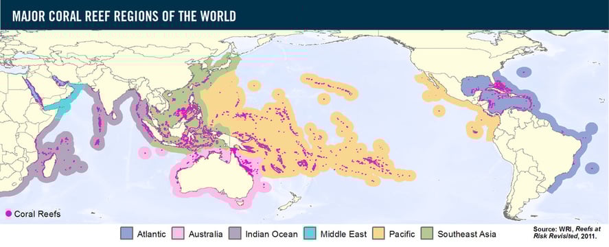
Coral reefs are large deposits of calcium carbonate built entirely of living organisms called coral polyps
Corals are scattered throughout the tropical and subtropical Western Atlantic and Indo-Pacific oceans, generally within 30°N and 30°S latitudes
Western Atlantic reefs include these areas: Bermuda, the Bahamas, the Caribbean Islands, Belize, Florida, and the Gulf of Mexico
The Indo-Pacific ocean region extends from the Red Sea and the Persian Gulf through the Indian and Pacific Oceans to the western coast of Panama
Corals grow on rocky outcrops in some areas of the Gulf of California
The Great Barrier Reef in northern Australia is renowned for its great biodiversity and size and can be seen from space
Their distribution is controlled by four factors:
Temperature
Light
Water depth
Salinity
What are the features of Coral Reefs?
Main Features of Coral Reefs
| Global Features |
Temperature | Corals cannot tolerate water temperatures below 18°C but grow best at 23°C – 29°C. Some can stand temperatures as high as 40° C for short periods. This is why coral reefs normally grow between the Tropic of Capricorn and the Tropic of Cancer |
Light | Corals need light for photosynthesis due to the algae, called zooxanthellae, that live in their tissue |
Water | Corals are generally found at depths of less than 25m where sunlight can penetrate. The water must also be clear and clean to allow for optimum photosynthesis to occur |
Salinity | Since corals are marine animals they need salty water to survive, ranging from 32-42% saltwater |
At a local level, other factors will affect development:
Wave action - corals need well-oxygenated, clean water and wave action provides this
Exposure to air - although corals need oxygenated water, they cannot be exposed to air for too long or they will die
Sediment - all corals need clear, clean water. Any sediment in the water will block normal feeding patterns by reducing the availability of light affecting the photosynthesis of the microscopic algae 'zooxanthellae' living in polyp tissue. The corals provide algae with a home and compounds for photosynthesis. In return, the algae produce food, and oxygen and help remove wastes
Types of Coral Reefs
Fringing Reefs - these are reefs that form around a land mass
Barrier Reefs - these are found parallel to the shore but are separated by a channel of water:
The Great Barrier Reef in the Coral Sea, off the coast of Queensland, Australia is a good example of a barrier reef.
It is the world's largest coral reef system with over 2,900 individual reefs and 600 islands that stretch for over 2,300 kilometres and can be seen from space
Atolls - horseshoe-shaped rings, consisting of a coral rim that encircles a lagoon
Distribution & Features of Mangroves
Distribution of Mangroves
Both mangroves and coral reefs are found in warm tropical waters, however, unlike the sensitive coral reefs, mangroves are highly adapted to changing conditions
This has made them the most successful ecosystems on Earth
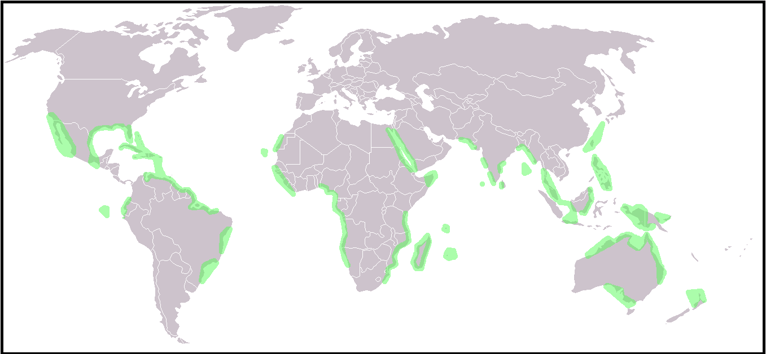
Global Distribution of Mangroves
Originate from Southeast Asia and spread across the globe
Mainly found in warm tropical waters and coastal swamps within 30° N and S of the equator
Some have adapted to more temperate conditions and have colonized as far south as New Zealand's North Island
They grow in the intertidal zone of the coast
South-East Asia has mangroves with the highest biodiversity in the world
Characteristics of Mangroves
Mangroves are trees that live on the coastline
They sit in water between 0.5 to 2.5 metres high
They range in size from small shrubs to trees over 60m high
They have numerous tangled roots that grow above ground and form dense thickets
They need high levels of humidity (75 - 80%) and rainfall per annum (1500 - 3000 mm)
The ideal temperature is around 27° C but are adapting to more temperate climates
The mangrove root system is complex, with a filtration system to keep salt out
Some have snorkel-like roots that stick out of the mud to help them take in air
Others use 'prop' roots or 'buttresses' to keep their trunks upright in the soft sediment at the tidal edge

Prop Roots Mangrove Root Systems Snorkel Roots
It is the roots that trap mud, sand and silt which eventually builds up the intertidal zone into the new land
At the same time, the mangrove is colonizing new intertidal areas
The fruits and seedlings of mangroves can float and can travel many kilometres on ocean currents
As they drift with the incoming tide, they become lodged in the mud and begin to grow, colonizing new areas
Distribution & Features of Sand Dunes
Distribution of Sand Dunes
Coastal sand dunes are found all over the world
They are the accumulation of sand, shaped into mounds and ridges by the wind
Found at the back of a beach, above the maximum reach of the tide

Global Distribution of Coastal Sand Dune Systems
Coastal sand dunes develop best when:
There is a wide beach and large quantities of sand
The prevailing wind is onshore
There is a large tidal range to allow time for the sand to dry
There are suitable locations for the sand to accumulate
Characteristics of Sand Dunes
Sand dunes can be small ridges or large hills usually found at the back of a beach
They can extend backwards for many miles as well as along the beach
They are an important ecosystem supporting unique flora and fauna that have adapted to live within the dune system
Dunes are vulnerable to erosion by natural processes and human activity:
It is common to see vulnerable sections of dunes fenced off to prevent public access, or for paths to be laid to prevent people from eroding the dunes further
Formation of a Sand Dune
Wind-blown sand is deposited against an obstruction - pebble or driftwood
As more sand particles are caught, the dunes grow in size, forming rows at right angles to the prevailing wind
Over time, the ridges of the dunes will be colonized and fixed by vegetation in a process called succession
The first plants (pioneer species) have to deal with:
Salinity
Lack of moisture as sand drains quickly (highly permeable)
Wind
Temporary submergence by wind-blown sand
Rising sea levels
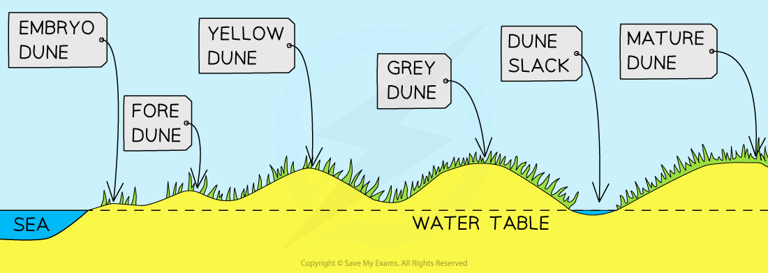
Coastal Sand Dune Succession
Embryo Dunes
Wind-blown dried sand is trapped by debris and deposition begins
Pioneer species such as Lyme Grass and Sea Couch Grass begin to colonise
There is little soil content and high pH levels (alkaline)
Embryo dunes are very fragile and reach a maximum height of 1 metre
Fore Dunes
The embryo dunes bring some protection against the prevailing wind
This allows other species of plant to grow such as Marram Grass
Marram grass begins to stabilise the dune with its root system
These plants add organic matter to the dunes making the dunes more hospitable for plants that later grow
A microclimate forms in the dune slack
Maximum height is 5 metres
Yellow Dunes
These are initially yellow but darken as organic material adds humus to the soil
Marram grass still dominates the vegetation, but more delicate flowering plants and insects are found in the dune slacks
20% of the dune is exposed, down from 80%
Height does not exceed 8 metres
Grey Dunes
Grey dunes are more stable, with less than 10% of exposed sand and have a good range of biodiversity
Soil acidity and water content increase as more humus is added
Shrubs and bushes begin to appear
Height is between 8 - 10 metres
Mature Dunes
As the name suggests, these are the oldest and most stable of the dunes
They are found several hundred metres or more from the shoreline
The soil can support a variety of flora and fauna such as oak trees and alders (climax vegetation)
This is the final stage in succession which is known as the climax community stage
Distribution & Features of Salt Marshes
Distribution of Salt Marshes
Salt marshes are found all over the world and are not temperature dependant
Like mangroves, they are an ecosystem of the intertidal zone
They are typically very flat, with numerous channels running through them
They form in:
Coastal areas that are well sheltered, such as inlets and estuaries where fine sediments can be deposited
Areas behind spits and artificial sea defences where tidal waters can flow gently and deposit fine sediments
They form in brackish water
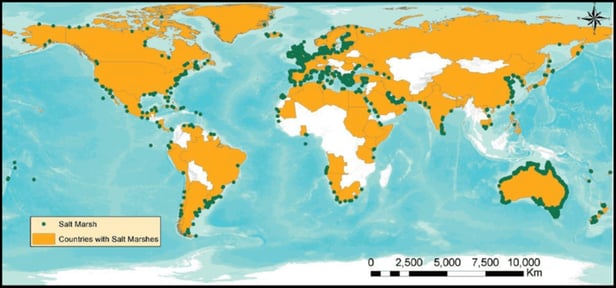
Global Distribution of Salt Marshes
Features of Salt Marshes
Salt marshes are communities of nonwoody, salt-tolerant plants
They begin as tidal mud flats, gaining height as more sediment is deposited
This builds up to and above the level, and frequency of tidal flooding ensuring that the soil never dries out and remains muddy and sticky
Pioneer species of halophyte plants begin to colonise
As these plants die and add nutrients to the soil, sediment builds up. This makes the conditions more favourable and other species start to develop.
The process of the development of vegetation, over time is known as succession. In a salt marsh, this is known as a halosere
The lower marshes are flooded daily by the rising tide.
They are good coastal defences in some areas, acting as a natural buffer against coastal erosion and flooding
However, in many areas they have been reclaimed for agriculture or development, and are threatened by human activities
Characteristics of Coral Reef Ecosystems
An ecosystem is a community of interacting biotic and abiotic organisms
All ecosystems, whether on land or in water function in the same way
All survive by nutrient cycling around three stores:
Biomass
Litter
Sea Water

Nutrient Cycle of a Coastal Ecosystem
Nutrient Cycle of Coastal Ecosystems
Overview of Coastal Nutrient Cycling
| Mangroves | Sand Dunes | Salt Marsh | Coral |
Nutrient Store | Mud /Sand | Mud /Sand | Mud / Sand | Sea Water Rivers Entering On-Shore Currents |
Biomass Store | Plants Animals | Plants Animals | Plants Animals | Coral Polyps Seaweed Fish, Crustaceans & Invertebrates |
Litter | Plants Animals | Plants Animals | Plants Animals | Dead Coral Polyps Seaweed Fish, Crustaceans & Invertebrates |
Degrades In | Water | Water | Water | Sea water |
Transfers | Water | Land | Water | Tidal & Ocean Currents |
THREATS:
Industrialisation
The Value of Coastal Ecosystems
All ecosystems offer people a range of opportunities – goods and services
Goods – a material resource that can be extracted and used
Services – general benefits and advantages
Coastal ecosystems can provide the following:
Goods | Services |
Fish Shellfish Salt | Protection from: Storms Coastal flooding Rising sea levels |
Fishmeal Animal feed | Harbours Natural Shelter |
Seaweed for: Food Industrial Use Medicines | Recreation Leisure opportunities |
Land for: Building Farming | Biodiversity Wildlife habitats |
Construction Materials: Sand Timber (Mangrove) | Natural waste treatment |
Industrial Threats
Threats to Coral Reefs
Coral reefs are easily stressed by human action, if the stress persists, then the death of the reef soon follows
Pollution, overfishing and quarrying of coral for building stone
Industrialisation is responsible for rising sea temperatures and sea-level rise, putting coral reefs under threat
Rising sea temperatures increase levels of coral bleaching
Threats to Mangroves
Pollution, overfishing and deforestation for aquaculture
Clearance for land development particularly in developing countries
Threats to Sand Dunes
Least threatened at a global level due to value being mainly tourism and leisure
Local level the biggest threat is sand mining
Threats to Salt Marsh
Industrial pollution
Ideal sites for nuclear power stations
Clearance for development - commercial and private
Development can lead to increased noise and light pollution which may affect wildlife behaviour and nesting
Agricultural Practices
Threats to Coral Reefs
Overfishing reduces the number of grazing fish that keep coral clear of algae
Fishing using explosives damage coral reefs
Commercial farming
Fertiliser runoff
Pesticide overspray
Threats to Mangroves
Aquaculture - intense fish and shrimp farms
Pesticide use
Antibiotics used in aquaculture practices
Clearance for farm development particularly in developing countries
Threats to Sand Dunes
Destabilisation due to grazing animals on dunes
Threats to Salt Marsh
Drained and cleared for farming
Eutrophication through heavy use of fertilisers
Pollution from pesticides and herbicides
Slurry run-off from cattle
Tourism
Threats to Coral Reefs
Tourism is the biggest threat globally and locally to coral reefs
58% of all coral reefs are at threat from human activity
Any contact with the human body is likely to kill coral immediately around the point of contact
Propellers and anchors directly damaging corals from boat tours
Pollution through diesel spills
Threats to Mangroves
Clearance of mangroves to build hotels and other tourist attractions
Diversion of fresh water to hotels etc
Disturbance of habitats
Collection of souvenirs by tourist
Tours in waterways and pollution through spills of boat fuel
Threats to Sand Dunes
Largest threat to sand dunes due to trampling of delicate, unfixed dunes
Driving using 4x4 or quadbikes over sand dunes
Sporting events - sand surfing etc
Collecting shells and driftwood
Pollution from rubbish left by tourists
Car parks
Sand mining for building hotels
Development of seaside towns
Threats to Salt Marshes
Tourism is limited to the local level and nature reserves
Roads have divided salt marshes cutting off parts of it
Trampling by visitors
Dog walkers letting dogs roam and disturb the wildlife
Noise from local tourist areas may disturb the wildlife
Deforestation
Threats to Coral Reefs
Clearance of coastal forests and mangroves disturbs natural flows of water and nutrients leading to stress and coral bleaching
Removal of coral reef for stone building or tourist sales
Any destruction of coral reef leaves the coastline open to coastal flooding and storm surges
Threats to Mangroves
Removal of the trees leads to the collapse of the ecosystem
Leaves the coast open to storms, flooding and coastal retreat
Mangrove wood is used for timber and fuel
Cleared to reduce malaria - unsupported evidence that this works
Threats to Sand Dunes
Removal of trees destroys the mature dunes and allows for dune migration
Leaves coast open to storms and flooding
Threats to Salt Marshes
Real threat is through industrialisation and agriculture
Conflict Between Development & Conservation
Careful management of coastal regions is necessary for sustainability
Coastal environments have multiple uses:
Development such as homes, shops, roads etc.
Nature reserves
Industry such as ports, fishing and aquaculture
Tourism
Agriculture
These different activities bring people and ecosystems together and there becomes a competition for space
Conflict arises when coastal development is given a higher priority than coastal conservation
Conflict Between Coastal Users
Coastal users and wildlife are referred to as stakeholders
Each stakeholder has a different priority or need
Wildlife want an unpolluted, safe and quiet environment
Local residents want jobs, clean beaches, affordable housing and schools
Tourists want beaches, hotels, B&Bs, entertainment, holiday homes, and marinas
Employers want building space, offices, and factories
Developers want areas by the sea for tourists—hotels, duplexes, golf courses
Fishermen want harbours, unpolluted waters, and ease of access to the sea
Farmers want well-drained land, sheltered from prevailing winds
Government and Councils want to build offshore wind farms and coastal defences
Transport companies want good road networks, well-connected ports and terminals
The different needs of stakeholders often conflict as they compete for the same resources
Relationship between Stakeholders and Coastal Zone Issues
Stakeholder Activity | Consequences | Outcomes |
Agriculture | Fertiliser and pesticide overuse, increased livestock density, overwater abstraction, animal waste disposal, land reclamation | Species and habitat loss, eutrophication, water pollution, coastal squeeze |
Urbanisation and Transport | Change of land use (car parks, ports, etc.) waste disposal, pollution, water abstraction, hard road surfaces | Increased flooding, congestion, pollution, loss of habitats, increase in weeds and invasive species |
Tourism and Recreation | Harbours, marinas, waste disposal, fuel spillages, change of land use, water abstraction, effluent disposal | Congestion and pollution (noise, light, visual, aroma), loss of habitats, loss of species, litter and fuel spills |
Fisheries and Aquaculture | Ports, fish processing facilities, trawlers, road networks, lorries, fishing gear, fish farm pollution, water abstraction | Overfishing, pollution on beaches, habitat damage, water pollution, aroma, visual and noise pollution from trawlers, and increased seagull activity |
Industry | Land use change, change in tidal range, power stations (nuclear and gas), natural resource extraction, road networks, cooling water/abstraction, waste pollution (chemical, biological, nuclear, etc.). | Thermal pollution, habitat destruction, change and loss, water eutrophication, water pollution, visual eyesore |
The level of conflict varies depending on who and what the needs are
This can be shown in a conflict matrix
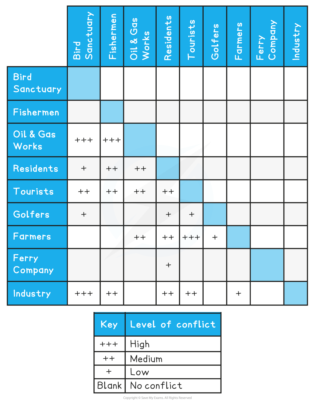
Conflict Matrix
Causes of Coastal Flooding
Coastal flooding results from a number of factors:
Storm surges - a rapid rise in sea level caused by really low-pressure storms (e.g. tropical storm)
Storm tides - occur when there is a combination of high tide and low-pressure storm
Tsunamis - large sea waves due to underwater earthquakes. The closer to the coast, the bigger the impact
King tides
Sea level rise due to global warming
High river discharge after a storm - when combined with a spring tide, water in the estuary cannot discharge into the sea causing a backflow of water and flooding
The worst flooding arises from a combination of any of these
The biggest impacts are felt by emerging countries, although the biggest economic cost is are to developed countries
Prediction & Prevention of Flooding
Prediction
Early warning systems allow communities to prepare (evacuate or take shelter) before flooding occurs
Two methods are used to help forecast coastal flooding:
Past records (diaries, newspapers, government/council records etc)
These will identify areas that are at high risk of flooding and their frequency
Modern technology - GIS, satellite and computer monitoring, weather stations (local and national) etc
These allow for forecasting and tracking potential hazard events i.e.
Tropical storms - track the storm's path and associated storm surge
Earthquakes - size and position if underwater and possible tsunami outcome
Both these methods of forecasting help officials to say when and where the event will occur
It indicates the possible strength and scale of the flooding, and the likelihood of damage and death
Prevention
Prevention is about taking action that reduces or removes the risk of coastal flooding
Actions include:
Flood defences
These are built along high-risk stretches of coast
Emergency centres
Centrally placed on higher ground where people can be safe from flooding
Early warning systems
Allows for preparation or evacuation of an area
Education
Informing local people on what to do if and when a flood occurs
Planning
Planning any new development away from high-risk-areas
Designing buildings to cope with low levels of flooding
Elevating buildings so that flood waters can pass underneath
Floodproof buildings with raised foundations (fixed or mechanical)
Reinforced barriers
Dry floodproofing - sealing a property so that floodwater cannot enter
Wet floodproofing - allows some flooding of the building
Buffer zones
Areas of land are allowed to flood before reaching settlements
This allows the energy in the surge to dissipate slowing down the distance the floodwater will travel
It can mean moving people away from the coast which could be controversial
Coastal Strategies
Management of coastal regions is performed by identifying coastal cells
This breaks a long coastline into manageable sections and helps identify two related risks:
The risk of erosion and land retreat
The risk of flooding
Identification allows resources to be allocated effectively to reduce the impacts of these risks
The 'cost-benefit' is easier to calculate using coastal cells
Shoreline Management Plans
Shoreline Management Plans (SMP) set out an approach to managing a coastline from flooding and erosional risk
The plans aim to reduce the risk to people, settlements, agricultural land and natural environments (salt marshes etc.)
There are four approaches available for coastal management, with differing costs and consequences:
Hold the line
Long term approach and the most costly
Build and maintain coastal defences so the current position of the shoreline remains the same
Hard engineering is the most dominant method used with soft engineering used to support
Advance the line
Build new defences to extend the existing shoreline
Involves land reclamation
Hard and soft engineering is used
Managed realignment
Coastline is allowed to move naturally
Processes are monitored and directed when and where necessary
Most natural approach to coastal defence
Mostly soft engineering with some hard engineering to support
Do nothing
Cheapest method, but most controversial of the options
The coast is allowed to erode and retreat landward
No investment is made in protecting the coastline or defending against flooding, regardless of any previous intervention
Decisions about which approach to apply are complex and depend on:
Economic value of the resources that would be protected, e.g. land, homes etc
Engineering solutions - it might not be possible to 'hold the line' for moving landforms such as spits, or unstable cliffs
Cultural and ecological value of land - historic sites and areas of unusual diversity
Community pressure - local campaigns to protect the region
Social value of communities - long-standing, historic communities
Hard Engineering Methods
Hard engineering involves building some form of sea defence, usually from concrete, wood or rock
Structures are expensive to build and need to be maintained
Defences work against the power of the waves
Each type of defence has its strengths and weaknesses
Protecting one area can impact regions further along the coast, which results in faster erosion and flooding
Hard engineering is used when settlements and expensive installations (power stations etc) are at risk - the economic benefit is greater than the costs of building structures
Hard Engineered Defences
Strategy | Description | Advantages | Disadvantages |
Sea Wall | A wall, usually concrete, and curved outwards to deflect the power of the waves | Most effective at preventing both erosion and flooding (if the wall is high enough) | Very expensive to build and maintain It can be damaged if the material is not maintained in front of the wall Restricts access to the beach Unsightly to look at |
Groynes | Wood, rock or steel piling built at right angles to the shore, which traps beach material being moved by longshore drift | Slows down beach erosion Creates wider beaches | Stops material moving down the coast where the material may have been building up and protecting the base of a cliff elsewhere Starves other beaches of sand. Wood groynes need maintenance to prevent wood rot Makes walking along the shoreline difficult |
Rip-rap | Large boulders are piled up to protect a stretch of coast | Cheaper method of construction Works to absorb wave energy from the base of cliffs and sea walls | Boulders can be eroded or dislodged during heavy storms |
Gabions | Wire cages filled with stone, concrete, sand etc | Cheapest form of coastal defence Cages absorb wave energy Can be stacked at the base of a sea wall or cliffs | Wire cages can break and they need to be securely tied down Not as efficient as other coastal defences |
Revetments | Sloping wooden or concrete fence with an open plank structure | Work to break the force of the waves Traps beach material behind them Set at the base of cliffs or in front of the sea wall Cheaper than sea walls but not as effective | Not effective in stormy conditions Can make beach inaccessible for people Regular maintenance is necessary Visually unattractive |
Off-shore barriers | Large concrete blocks, rocks and boulders are sunk offshore to alter wave direction and dissipate wave energy | Effective at breaking wave energy before reaching the shore Beach material is built up Low maintenance Maintains natural beach appearance | Expensive to build Can be removed in heavy storms Can be unattractive Prevents surfing and sailing |
Soft Engineering Methods
Soft engineering works with natural processes rather than against them
Usually cheaper and do not damage the appearance of the coast
Considered to be a more sustainable approach to coastal protection
However, they are not as effective as hard engineering methods
Soft Engineered Defences
Strategy | Description | Advantages | Disadvantages |
Beach replenishment | Pumping or dumping sand and shingle back onto a beach to replace eroded material | Beaches absorb wave energy Widens beachfront | Has to be repeated regularly which is expensive Can impact sediment transportation down the coast |
Fencing, hedging, and replacing vegetation | Helps to stabilise sand dunes or beaches Reduces wind erosion | Cheap method to protect against flooding and erosion | Hard to protect larger areas of coastline cliffs |
Cliff regrading | The angle of a cliff is reduced to reduce mass movement | Prevents sudden loss of large sections of cliff Regrading can also slow down wave cut notching at the base of cliffs as wave energy is slowed | Does not stop cliff erosion |
Managed retreat | Existing coastal defences are abandoned allowing the sea to flood inland until it reaches higher land or a new line of defences | No expensive construction costs Creates new habitats such as salt marshes | Disruptive to people where land and homes are lost The cost of relocation can be expensive Compensation to people and businesses may not be paid |
There are conflicting views about using a particular type of engineering for coastal defence
Most coastal managers aim to use a range of methods depending on the value of what is being protected
This method is known as Integrated Coastal Zone Management (ICZM)
ICMZ aims to use a combination of methods to best reflect all stakeholder needs