EAS 209 - Lecture 29
John "Jack" Horner
Paleontologist from Montana.
Inspiration for the character "John Allen" in Jurassic Park by Michael Crichton.
Never completed a university degree.
Took many geology and paleontology courses but dropped out.
Has dyslexia and found traditional schooling difficult.
Worked for several years operating heavy equipment in his brother's gravel company.
Maintained a strong passion for paleontology despite leaving university.
Wrote to numerous museums seeking employment opportunities.
Received multiple offers, including positions associated with Princeton, the University of Toronto, and Los Angeles.
Chose to work at Princeton with his wife and child.
Started as a museum assistant curator.
Later promoted to research associate.
Wrote research grants despite not having a PhD.
Required supervisors to formally sign grant applications.
Conducted independent research and became highly productive scientifically.
Published numerous papers and became recognized for his research abilities.
Eventually returned to Montana and continued museum-based research.
Proposed that some dinosaurs nested communally after discovering nesting sites and egg clutches.
Suggested dinosaurs may have provided parental care.
Famously proposed that Tyrannosaurus rex was primarily a scavenger.
Later modified that interpretation toward T. rex being more of an opportunistic feeder.
Served as a paleontology consultant for the Jurassic Park films.
Continues to be active in paleontology.
Has supervised graduate students.
Represents an example of success through persistence and passion despite taking a non-traditional academic route.
Recognized as an important scientist despite lacking formal graduate degrees.
Jurassic Dinosaurs Mentioned
Discussion provided for interest only and not required for exams.
Examples of Jurassic dinosaurs:
Stegosaurus.
Brachiosaurus.
Pterodactyl.
Allosaurus.
Diplodocus.
Archaeopteryx.
Tyrannosaurus rex was not Jurassic; it lived during the Cretaceous.
The film Jurassic Park contains many dinosaurs that actually lived during the Cretaceous.
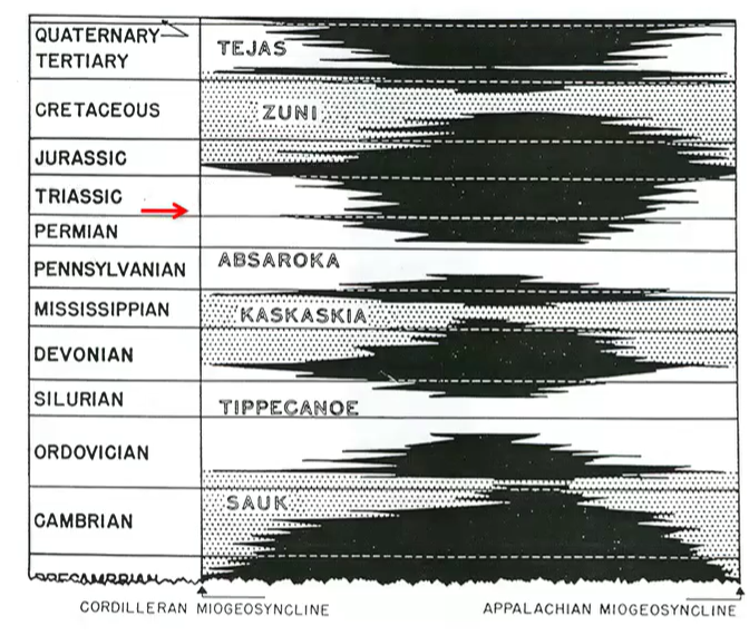
The Absaroka/Zuni Boundary is E/M Jurassic, but in WCSB, the M/L Jurassic boundary is more significant.
The sequence boundaries and the time period boundaries don’t always match.
Transition from the Absaroka Sequence to the Zuni Sequence
Transition occurs during the Jurassic.
An unconformity separates the sequences.
After the unconformity, sea level begins rising again.
Rising sea level is recorded in the preserved rock record.
Sequence boundaries do not necessarily correspond with geologic period boundaries.
In western Canada, the Middle-to-Late Jurassic boundary is particularly significant.
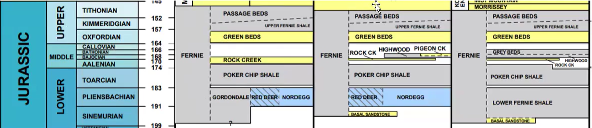
Jurassic Stratigraphy in Western Canada
Jurassic divided into:
Lower (Early).
Middle.
Upper (Late).
Presence of an important unconformity marked by missing stratigraphy.
The Fernie Formation represents most Jurassic rocks throughout Alberta and much of western Canada.
Fernie Formation contains several subdivisions:
Nordegg carbonate platform in southern Alberta.
Poker Chip Shale.
Rock Creek Member (sandstone-rich).
Passage Beds.
Cretaceous rocks overlie the Jurassic succession.
Mountain stratigraphy differs from subsurface stratigraphy.
Outcropping units often receive different names from subsurface units.

Burial History and Development of the Foreland Basin
Burial history of pre-Jurassic units (e.g. Exshaw Formation) shows abrupt increase in subsidence rate… transition of the basin to a foredeep.
Burial-history diagrams show depth through time.
Increasing burial reflects Cordilleran mountain building and terrane accretion.
Accreted island arcs, continental fragments, and oceanic fragments increased crustal loading.
Additional weight compressed the crust.
Compression produced subsidence.
Subsidence formed the foreland basin.
Based on the mass of the rock being piled up through compression, causing sagging.
Early terrane accretion began during the Triassic–Jurassic transition.
Initial accretion was insufficient to create major subsidence.
Significant subsidence began during the Late Jurassic.
Rocks were progressively buried to great depths.
Some rocks reached depths exceeding those encountered in modern drilling operations.
Example shown used Devonian and Carboniferous Exshaw Formation rocks near Fernie, British Columbia.
Diagram tracked burial depth of a specific rock package through geologic time.
Changes in Sediment Transport During the Jurassic
As we get into the Jurassic: accompanied by a change in sediment transport direction, with westerly-sourced clastic wedges and conglomerates (i.e. Cordilleran source).
Thinning of sediments to the east.
There are a number of Jurassic resources, as follows: phosphate, gypsum,
Basin configuration changed significantly.
Sediment transport directions changed.
Seaway geometry evolved.
Earlier sediment sources were primarily from the east.
Evidence later indicates significant sediment input from the west.
Western sediment source developed due to terrane accretion.
Accreted terranes formed a peninsula-like landmass.
Open ocean conditions became restricted.
Sediments thin eastward.
Jurassic basin increasingly received western-derived sediment.
Jurassic Resources
Phosphate
Potential is seen in the Lower Jurassic Nordegg Formation, but is currently subeconomic. It makes a terrific gamma ray log marker.
Occurs in Lower Jurassic Fernie Formation deposits.
Not economically significant at present.
Useful as a subsurface marker bed.
Slightly radioactive.
Radioactivity is detectable on gamma-ray logs.
Produces a distinctive signature in borehole geophysical logs.
Oolitic Phosphate
Consists of phosphate-rich ooids.
Ooids form as grains roll back and forth in shallow wave-agitated water.
Ooids are coated grains.
Comparable to grains moving in a beach swash zone.
These “swashes” move the grains back and forth slowly.
Algal coatings accumulate around grains.
Constant rolling produces concentric coatings.
Result is spherical coated grains.
Example shown from Crowsnest Pass.
Gypsum
Mined in Manitoba.
This is mined at Amaranth… Southern Manitoba.
The anhydrite of the Amaranth formation has undergone hydration.
Formed through rehydration of anhydrite.
Gypsum and anhydrite are interchangeable depending on water content.
Removing water from gypsum creates anhydrite.
Adding water to anhydrite creates gypsum.
Oil and Gas
Some Jurassic oil and gas exists.
Economic importance is relatively limited.
Not comparable to:
Oil sands.
Devonian Leduc reef production.
Coal
Major Jurassic resource.
Particularly abundant in the Mist Mountain Formation of the Kootenay Group.
Coal-bearing rocks are widespread in the Rocky Mountain region.
Important exposures occur near Fernie and Crowsnest Pass.

Jurassic Cross-Section and Basin Development
Cross-section extends west-to-east across the basin.
Upper Jurassic to Lower Cretaceous coal is hosted by Mist Mountain Formatoin of Kootenay Group.
Includes:
Sweetgrass Arch (the image refers to the sweetgrass arch). .
Williston Basin.
Deposits thin toward the Sweetgrass Arch.
Lower Jurassic contains evaporites at the base.
Evaporites correspond to low sea-level conditions near the Jurassic unconformity.
Shales, siltstones, and mudstones dominate much of the Jurassic succession.
Kootenay Group contains important coal-bearing units.
Coal-Bearing Units in the Rockies and Foothills
Younger Jurassic rocks occur to the north.
Older Jurassic rocks occur to the south.
Mist Mountain Formation contains substantial coal resources.
Grassy Mountain became the focus of proposed mining projects.
Proposed strip-mining operations generated significant public opposition.
Other important coal-bearing units include:
Luscar Formation.
Gates Formation.
Coal Valley deposits.
Wapiti area deposits.
Coal mining also occurred in parts of Alberta north of Edmonton near Wabamun Lake.
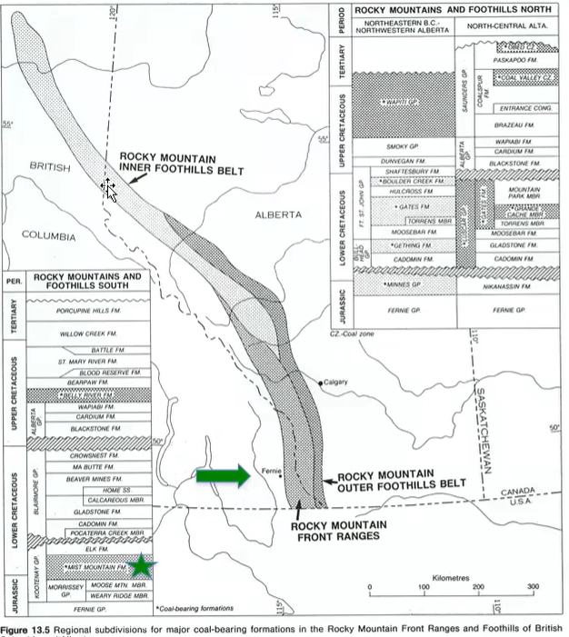
In simple terms, younger to the north, older to the south.
Jurassic is mostly coal-bearing.
Stipoli formations are being mined.
Jurassic Paleogeography
Fernie Sea occupied much of western Canada.
Cordillera was beginning to form.
Terranes were accreting onto western North America.
Accretion created a peninsula-like landmass.
Open ocean conditions became restricted.
Seaway entered from the north.
Sediment entered from both east and west.
Development of a foredeep occurred due to tectonic loading.
Extensive swamps formed around the seaway.
Western margin became the primary area of coal formation.
Fernie Sea:
The so-called Fernie Sea was a Jurassic foredeep, resulting from mountain folding; coal formed in fluvio-deltaic sediments deposited on its western margin.
River input bringing in sediment (coming from the east from the west).
Coal formed on the western margin.
Coal Formation
Coal formed from abundant vegetation accumulating in swampy environments.
Woody plant material accumulated in stagnant water.
Stagnant water limited oxygen availability.
Low oxygen slowed decomposition.
Organic matter was preserved rather than consumed.
Preserved organic matter initially formed peat.
Burial and compression transformed peat into coal.
Heating and compaction removed water and volatile compounds.
Carbon concentration increased through time.
Essentially:
Vegetative organic matter, especially lignified/woody materials, accumulates in stagnant water, is buried and thermally matured.
Volatiles (e.g. H, O, N) are driven off, leading to increased C content and latent hear, and decreasing moisture and porosity; rank increases.

Coal Rank Progression
Peat:
Initial stage.
Organic-rich plant material.
Contains many impurities and water.
Lignite:
Soft brown coal.
Formed through burial and compaction.
Better fuel source than peat.
Bituminous Coal:
Formed through further burial and heating.
Common fuel source for power generation.
Anthracite:
Highest-grade coal.
Produced by extensive heating and metamorphism.
Very hard.
Black and shiny.
Consists largely of concentrated carbon.
Large volume reduction occurs during coal formation.
Approximately ten metres of peat may produce only about one metre of coal.
Note: The progression to a more nearly pure C product.
High (bituminous [to semi-anthracite]) rank of these WCSB coals is due to tectonic burial.
As well, compression and thrust faulting has led to thickening.
Grassy Mountain Coal Deposit
Located near the Frank Slide area.
Coal seams are concentrated within a fold.
Folding thickens the coal zone.
Structural thickening increases economic attractiveness.
Historic mining has occurred in the area.
Proposed large-scale strip mining generated controversy.
Introduction to Dinosaur Provincial Park
Dinosaur Provincial Park is located near Brooks, Alberta.
Situated along a river.
Contains campgrounds and tourist facilities.
Considered a major paleontological destination.
Drumheller and the Royal Tyrrell Museum are also highlighted as important dinosaur-related attractions.

Oldman Formation
Very finefine grain sandstone.
Typically Braided River Deposition.
Sediment from the SW.
Sandstone mature, mainly quartz with love %age of volcanic lithics.
Through cross-stratification, climbing ripples.
Represents the oldest unit discussed during the field trip.
Depositional environment interpreted as a braided river system.
Modern analog shown using the South Saskatchewan River.
Dominated by:
Very fine-grained sandstone.
Fine-grained sandstone.
Sediment source came primarily from the southwest.
Sediment considered mature.
Grains were transported long distances.
Grains became worn and rounded during transport.
Composition is mostly quartz.
Contains minor volcanic material.
Displays trough cross-stratification.
Indicates channelized river deposition.
Contains climbing ripples.
Indicates relatively fast-flowing water.
Represents a braided river environment with multiple shifting channels.
Braided River Characteristics
Braided rivers occupy a broad area called a braid plain.
Individual channels do not occupy the entire braid plain at one time.
Multiple channels weave and cross one another.
Channels continually shift position.
No permanent fixed channel exists.
Channels migrate across the braid plain through time.
Commonly associated with:
Higher-energy water.
Coarser sediment.
Areas closer to mountain sources.
Greater slope and higher discharge contribute to braided conditions.
Dinosaur Park Formation
Fine to medium grain sandstone.
Typically a Meandering river system.
Sediment coming from the NW.
Volcanic fragments are common.
Lateral accretion surfaces.
Younger than the Oldman Formation.
Deposited in a meandering river system.
Contains:
Fine-grained sandstone.
Medium-grained sandstone.
Distinct from braided river deposits because rivers occupy defined channels.
River channels are stable enough to maintain recognizable pathways.
Channels curve and loop through the landscape.
Sediment source shifted dramatically.
Sediment now arrived primarily from the northwest.
Increased abundance of volcanic material.
Indicates a significant change in regional sediment supply.
Suggests increased volcanic activity during deposition.
Represents an important environmental transition from the Oldman Formation.
Meandering River Characteristics
Rivers occupy a single defined channel.
Channel follows a winding path.
River loops repeatedly across the landscape.
Unlike braided rivers, water is not spread across a braid plain.
Sediment and water remain concentrated in a channel.
Channel migrates gradually through time.
Produces distinctive sedimentary structures and deposits.
Bearpaw Formation
An old seaway.
Transgression and marine.
Dark ray to brown marine shales.
Youngest unit discussed during the field trip.
Represents a marine environment.
Deposited during a marine transgression.
Consists primarily of marine shale.
Indicates return of the sea into the region.
Contains marine fossils such as ammonites.
Many ammonites became preserved as ammolite.
Ammolite
Produced from certain ammonite fossils.
Preserves iridescent shell material.
Displays bright reflective colors.
Comparable to the sheen observed inside modern shells.
Commonly used in jewelry.
Jewelry production often involves breaking apart fossil specimens.
Instructor notes that many beautiful fossils are destroyed in this process.
Ammolite is considered visually spectacular despite the loss of fossil integrity.

Cretaceous Seaway Evolution
Jurassic seaway began developing from the north.
During the Early Cretaceous:
Seaway connected fully with the Gulf of Mexico.
North America became divided by a major inland sea.
During the Late Cretaceous:
Sea level began to retreat.
Seaway became less extensive.
Marine incursions still occurred periodically.
Large portions of the continent remained influenced by marine conditions.
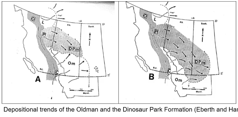
Changing Sediment Sources Through Time
Oldman Formation:
Sediment primarily derived from the southwest.
Dinosaur Park Formation:
Sediment primarily derived from the northwest.
Volcanic content increased in younger deposits.
Change may reflect tectonic activity associated with terrane accretion.
Regional drainage systems were reorganized.
New volcanic source regions became important contributors.

Thin Section Analysis
Rocks can be cut into very thin slices for microscopic study.
Thin sections are approximately 30 microns thick.
Thin enough to transmit light.
Examined using petrographic microscopes.
Different minerals interact with light differently.
The way they react to light is diagnostic.
Optical properties allow mineral identification.
Quartz in Thin Section
Quartz transmits light effectively.
Shows characteristic behavior under polarized light.
Changes color depending on light polarization.
Common component of the sandstone.
Volcanic Fragments in Thin Section
Often appear darker.
Commonly transmit light poorly.
Frequently require reflected-light techniques for study.
Increase in abundance within Dinosaur Park Formation deposits.
Information Obtained from Thin Sections
Grain size.
Grain shape.
Grain roundness.
Mineral composition.
Relative abundance of volcanic versus non-volcanic material.
Transport history of sediment.

Dinosaur Provincial Park Landscape
Famous for badlands topography.
Contains numerous hoodoos and erosional features.
Exposes extensive Cretaceous deposits.
Provides excellent opportunities to observe sedimentary structures and fossils.
Oldman Formation–Dinosaur Park Formation Boundary
Visible in outcrop.
Color change might initially suggest the wrong boundary location.
Actual stratigraphic boundary occurs at a specific horizon rather than simply where colors change.
Demonstrates importance of careful geological observation rather than relying solely on color differences.
Safety Considerations in Dinosaur Provincial Park
Cretaceous rocks contain abundant clay.
Bentonite clay becomes extremely slippery when wet.
Wet conditions make hiking hazardous.
Surface can behave almost like glare ice after rainfall.
Hiking is discouraged during rainy weather.
Southern Alberta contains rattlesnakes.
Visitors should:
Remain alert.
Stop if a rattle is heard.
Seek medical attention immediately if bitten.
Stop 1: Ripple Marks in the Oldman Formation
Ripple marks preserved within sandstone.
Comparable to ripples forming today after rainfall or flowing water.
Represent sediment movement in the braided river system.
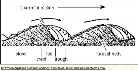
Cross-laminated foresets are clearly visible.
Similar sedimentary structures were observed during the Jasper field trip.
Ripple Formation
Sediment grains move up the stoss side of a ripple.
Grains avalanche down the lee side.
Accumulation on the lee side creates foreset beds.
Stoss side commonly erodes away.
Foresets are preferentially preserved.
Foresets record ancient flow directions.
Determining Paleocurrent Direction
Direction can be inferred from foreset orientation.
Sediment effectively "slides" down the lee side.
Flow direction corresponds to the direction of sediment movement down foresetsh

Stop 2: Unionid Steinkerns
Steinkern: Is when sediment fills in and lithifies around the organism and creates a mold. The shell later dissolves from the ground water leaving a cast of the mold.
The narrow end of Unionids typically face upstream to paleocurrent flow. h0Feature consists of steinkerns rather than true fossils.
Organism itself has dissolved away.
Sediment filled the interior of the shell.
Sediment later lithified.
Result is a natural internal mold.
Represents the original shape of the organism without preserving original shell material.
Unionids
Type of mollusk.
Occur in dense accumulations forming mollusk beds.
Useful for reconstructing ancient water flow directions.
Using Unionids to Determine Paleocurrents
Living unionids orient their shell openings upstream.
Orientation allows them to filter incoming water.
Fossil orientations can therefore indicate ancient current directions.
Modern examples from Alberta's Battle River show similar behavior.

Stop 3: Hadrosaur Bone
Hadrosaurs are commonly called duck-billed dinosaurs.
Example shown is Parasaurolophus, which belongs to the hadrosaur group.
A hadrosaur leg bone was observed preserved within the sediment.
Fossil bones are often associated with reddish or rusty coloration.
Rust coloration forms because organic matter affects local redox conditions during decay.
These redox changes can cause iron minerals to precipitate around the fossil.
Fossil bones can often be recognized by:
Linear surface textures.
Striations on the exterior.
Internal porous structure.
The internal texture resembles small cavities or holes.
The appearance s similar to porous toffee or honeycomb candy.
This porous texture helps distinguish fossil bone from ordinary rock.
Bone Beds
Bone beds contain concentrated accumulations of fossil bones.
Dinosaur Provincial Park contains numerous bone-rich horizons.
Bone beds commonly display rusty coloration associated with organic decay.
Fossil decay changes local chemical conditions.
These chemical changes can lead to precipitation of iron-rich minerals.
Mineral precipitation may produce reddish concretions.
Concretions and Fossils
Rounded reddish nodules may contain fossils.
These nodules form because microbial decomposition alters surrounding chemistry.
Iron-rich minerals precipitate around the decaying organic matter.
The fossil becomes enclosed within a concretion.
Breaking open a concretion may reveal the fossil inside.
Concretions therefore often serve as indicators of fossil preservation.
Characteristics of Fossil Bone Fragments
Exterior often displays linear textures or striations.
Interior displays a porous structure.
Rib fragments commonly appear elongated and tubular.
Numerous fragments become concentrated at the surface through erosion.
Rainstorms expose bones from surrounding sediment.
Wind further removes sediment and concentrates resistant bone fragments.
Repeated erosion gradually creates bone-rich surface accumulations.
Preservation and Exposure of Bone Beds
Fossils originally buried in sediment.
Rainfall erodes surrounding rock.
Wind removes finer sediment.
Resistant bone fragments remain behind.
Repeated erosion events increase fossil concentration at the surface.
Bone beds therefore represent both original fossil accumulations and subsequent erosional concentration.

Stop 4: Ornithomimid Quarry
Ornithomimids are dinosaur relatives similar to Gallimimus.
Instructor references the running herd scene from Jurassic Park.
Royal Tyrrell Museum operates fossil quarries within Dinosaur Provincial Park.
One quarry produced an Ornithomimid skeleton.
Skeletons recovered from these sites contribute significantly to dinosaur research.
Changing Interpretations of Dinosaurs
Early reconstructions portrayed dinosaurs as giant reptiles.
Dinosaurs were often shown with:
Tight skin.
Scaly bodies.
Lizard-like appearance.
New fossil discoveries changed these interpretations.
Feather impressions have been discovered on some dinosaurs.
Evidence suggests many dinosaurs were feathered.
Modern reconstructions often depict dinosaurs more like large birds.
Dinosaurs are increasingly viewed as bird-like rather than reptile-like.
Instructor humorously describes them as "big scary birds."
Current reconstructions are considered more scientifically accurate than older models.
Plant Fossils
Dinosaur Provincial Park preserves leaf impressions.
Fossil leaves can preserve:
Stems.
Veins.
Overall leaf shape.
Many leaf fossils closely resemble modern leaves.
These fossils provide information about ancient vegetation.
Plant fossils help reconstruct ancient ecosystems and climates.

Meandering River Deposits
Meandering river deposits occur within the Dinosaur Park Formation.
Ancient channels can be recognized in outcrop.
Channels appear thicker in some areas and thinner in others.
Thick portions represent deeper parts of the river.
Channel geometry reveals ancient river morphology.
Channel Architecture
Meandering rivers have:
A steep side.
A gently sloping side.
Thickest sediment accumulation commonly occurs near the deeper portion of the channel.
Channel margins become thinner away from the deepest section.
Ancient channels can therefore be reconstructed from preserved sediment geometry.
Channel Migration
Meandering rivers remain confined within channels.
However, channels migrate laterally through time.
Due to differences in velocity of the water.
Ancient channel positions can be identified from preserved sediment packages.
Successive channel margins record movement of the river.
In the example shown, the river migrated northward.
Multiple abandoned channel positions remain preserved in the stratigraphic record.

Modern Analog: Ucayali River
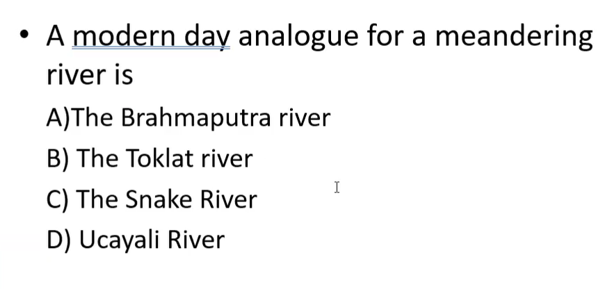
Ucayali River in Peru serves as a modern example.
Historical imagery shows river movement through time.
River behaves like a slowly moving snake.
Meanders migrate across the floodplain.
Migration occurs because water velocities vary within bends.
Velocity Differences in Meandering Rivers
Water on the outside of a bend travels farther.
Faster flow develops on the outside of bends.
Water on the inside of a bend travels a shorter path.
Slower flow develops on the inside of bends.
These velocity differences control erosion and deposition.
Cut Banks
Located on the outside of river bends.
Experience the fastest water flow.
Subject to active erosion.
Develop steep slopes.
River continually removes sediment from the cut bank.
Erosion causes channel migration.
Point Bars
Located on the inside of river bends.
Experience slower water flow.
Sites of sediment deposition.
Sediment accumulates gradually over time.
Produce gently sloping surfaces.
Record lateral migration of the river.
Formation of Oxbow Lakes
Continued erosion can cause a river bend to intersect itself.
River eventually creates a shorter pathway.
Original meander loop becomes abandoned.
Isolated water body forms.
This abandoned channel segment is called an oxbow lake.
Oxbow lakes preserve evidence of former river positions.
Thalweg
Thalweg is the deepest part of the river channel.
Located near the outside bend where flow is fastest.
Represents the zone of greatest erosional energy.
Often associated with cut-bank development.
Summary of Meandering River Components
Cut bank:
Fast water.
Erosion.
Steep slope.
Point bar:
Slow water.
Deposition.
Gentle slope.
Thalweg:
Deepest part of channel.
Maximum flow velocity.
Oxbow lake:
Abandoned meander loop.
Practical Example: Riverbank Erosion
Houses built on cut-bank sides of rivers are vulnerable.
Example given using the North Saskatchewan River in Edmonton.
Continuous erosion undercuts slopes.
Eventually slope failure and collapse can occur.
Cut-bank locations are therefore poor choices for long-term construction.
Trough Cross-Stratification in Channels
Commonly develops within river channels.
Forms as sediment migrates and accumulates.
Preserved within channel-fill deposits.
Useful for identifying ancient river environments.
Dinoturbation (Dino Footprint):
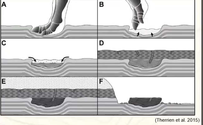
The sediment is squished down because a dinosaur stepped there.
Dinosaur Footprints
Dinosaur footprints are preserved in some sediments.
Footprints form when dinosaurs walk across soft sediment.
Weight compresses underlying layers.
Deformed sediment remains preserved after burial.
Additional sediment later fills the depression.
Preservation records both the footprint and associated deformation.
Footprint Formation Process
Dinosaur steps into soft mud.
Sediment compresses beneath the foot.
Foot is withdrawn.
Depression remains.
New sediment fills the depression.
Burial preserves the structure.
Later erosion exposes the footprint.
Trackway Interpretation
Three-toed footprints are visible in some examples.
Footprints provide evidence of dinosaur movement.
Trackways reveal behavior and locomotion.
Museums near Grande Prairie have preserved extensive dinosaur trackways.

Hoodoos and Badlands Erosion
Hoodoos are common in Dinosaur Provincial Park.
Form primarily through erosion.
Wind is an important erosional agent.
Rainwater also contributes significantly.
Erosion preferentially removes softer sediment.
Resistant sediment remains standing.
Stages of Hoodoo Formation
Landscape initially exists as a plateau.
Erosion creates gullies and valleys.
Wind and runoff exploit weaknesses in the rock.
Continued erosion isolates pillars.
Remaining pillars become hoodoos.
Additional erosional features include:
Fins.
Windows.
Cliffs.
Isolated pinnacles.
ANS: D