Hazardous environments
Some places are more hazardous than others
Characteristics, distribution and measurement of different types of natural hazards including tropical cyclones, earthquakes and volcanoes
Natural hazards are extreme natural events that have the potential to cause death, injury, or disruption to human activity and the environment.
Types of hazards studied:
Earthquakes: Sudden shaking of the ground caused by stress release along faults or tectonic boundaries.
Volcanoes: Eruptions of molten rock, ash, gases, and pyroclastic material from the Earth’s interior.
Characteristics of tropical cyclones
Very strong winds (often over 120 km/h)
Heavy rainfall → flooding and landslides
Storm surges → coastal flooding
Circular shape, eye at the centre, bands of rain and wind around
Distribution:
Earthquakes:
Concentrated along tectonic plate boundaries (especially convergent and transform).
High activity in the Pacific Ring of Fire, parts of Asia, and the Mediterranean.
Volcanoes:
Also found along tectonic plate boundaries, especially subduction zones.
Hotspots exist in isolated locations (e.g., Hawaii, Iceland).
Cyclones:
Found in tropical regions between the Tropic of Cancer and Capricorn
Develop over warm oceans (above 27°C)
Common in the Atlantic, Pacific and Indian Oceans
Move westward due to trade winds, then curve away at higher latitudes
Measurement:
Earthquakes:
Richter Scale: Measures magnitude (logarithmic), most commonly used and most effective
Moment Magnitude Scale (MMS): Replaces Richter for large quakes; considers seismic moment.
Mercalli Scale: Measures intensity (effects felt by people).
Volcanoes:
Volcanic Explosivity Index (VEI): Scale 0–8 based on volume of erupted material and cloud height.
Limitations:
Ash is not the main product of all hazardous volcanic eruption.
While some eruptions are explosive with rock and she blasted from the vent, others are effusive with lava flowing from the vent.
Therefore, the VEI is only suite to the assessment of on type of volcanic eruption
Tropical cyclones:
Saffir–Simpson scale (Category 1–5 based on wind speed)
Measured using satellites, radar, aircraft reconnaissance
Causes of volcanic and earthquake hazards, including the role of plate boundaries and hotspots
Plate tectonics: The Earth's lithosphere is divided into large plates that move due to convection currents in the mantle.
Plate boundaries:
Constructive (Divergent)
Plates involved: Typically Oceanic-Oceanic or Continental-Continental
Motion: Plates pull apart due to rising convection currents; cracks and fissures allow magma to escape; new crust is formed as magma cools
Effect: New land is created; magma erupts and cools on the surface
Landforms: Undersea mountain ridges (e.g. Mid-Atlantic Ridge); volcanic islands (e.g. Iceland)
Volcanic activity: Frequent volcanic activity; lava is runny and eruptions are gentle
Seismic activity: Frequent but small earthquakes
Example: Iceland, Mid-Atlantic Ridge
Destructive (Convergent) – Oceanic-Continental
Plates involved: Oceanic plate and Continental plate
Motion: Oceanic plate (denser) subducts under continental plate; driven by convection currents
Effect: Oceanic crust destroyed at subduction zone; intense pressure and friction melt the oceanic plate
Landforms: Deep ocean trenches (e.g. Peru-Chile trench); fold mountains (e.g. Andes); volcanoes
Volcanic activity: Explosive and dangerous volcanic eruptions; magma is viscous
Seismic activity: Frequent and strong earthquakes
Example: Andes Mountains
Destructive (Convergent) – Oceanic-Oceanic
Plates involved: Two oceanic plates
Motion: One oceanic plate subducts beneath the other; generates pressure and melting in the mantle
Effect: Formation of ocean trenches and volcanic island arcs
Landforms: Ocean trenches; underwater mountain chains; volcanic islands
Volcanic activity: Yes, explosive underwater volcanoes
Seismic activity: Yes, frequent and strong earthquakes
Example: Philippine Trench
Collision (Convergent) – Continental-Continental
Plates involved: Two continental plates
Motion: Plates collide but neither subducts; crust is forced upward
Effect: No crust destroyed; formation of massive mountain ranges
Landforms: Fold mountains (e.g. Himalayas)
Volcanic activity: No volcanoes
Seismic activity: Yes, strong earthquakes
Example: Mount Everest, Himalayas
Conservative (Transform)
Plates involved: Any two plates sliding past each other
Motion: Plates slide past each other; pressure builds up and is suddenly released
Effect: No crust is created or destroyed; movement causes sudden jolts
Landforms: Cracks, faults; sometimes mountains
Volcanic activity: No volcanic activity
Seismic activity: Yes, frequent and powerful earthquakes
Example: San Andreas Fault (California)
Hotspots:
Occur away from plate boundaries.
Stationary plumes of magma rise through the mantle, melting the crust.
Example: Hawaiian Islands chain.
Earthquakes:
An earthquake is a sudden and brief period of intense ground shaking
This occurs when plates move against each other, creating friction and leading to a build up to pressure which is eventually released
Energy is released in series if waves
The ground movement can be both vertical and horizontal
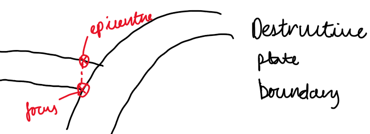
The centre of the earthquake underground is called the focus
The point on the surface above the focus is the epicenter; this is where there is most intense ground shaking
The amount of damage caused by a earthquake depends on the depth of the focus and the type of rock, as well as the development of a country and the location of the epicentre
The worst damage happens when the focus is close to the surface and the rocks are soft
Earthquakes under the sea can produce tsunamis
Volcanoes:
There are two broad types of volcanic eruptions:
At constructive plate margins and hot spots, eruptions are gentler, more regular, and involve runny lava
At destructive margins, eruptions are more violent, infrequent, and irregular
Examples:
Mt Stromboli – Destructive
Bardarbunga, Iceland – Constructive
Papua New Guinea – Destructive
Kilauea, Hawaii – Constructive (hot spot)
Eruptions occur due to gas pressure building up in the mantle
Volcanoes form from repeated eruptions and deposited material
Runny magma causes gentle eruptions and shield volcanoes
Sticky magma causes explosive ash eruptions and cone volcanoes
Hazards of volcanoes:
Tephra
Tephra includes volcanic rock, ash, pumice, and lava bombs blasted into the air. It rises high due to its heat and is highly disruptive—coating surfaces, entering openings, and damaging engines. In aircraft, tephra melts and clogs turbines, stalling engines. It can move at speeds up to 100 km/h.
Pyroclastic Flow
A fast-moving, ground-hugging mix of hot rock and gas that destroys nearly everything in its path. Speeds exceed 80 km/h with temperatures from 200–700°C. It doesn't rise like ash but surges outward from the vent.
Lava
Molten rock flowing from eruptions, either gently or explosively. It destroys anything in its path but usually moves slowly enough for evacuation.
Poisonous Gases
Released during eruptions, harmful gases like sulphur dioxide, carbon dioxide, and hydrogen fluoride threaten people, animals, and crops. CO₂ from Lake Nyos (Cameroon, 1986) suffocated 1,700 people.
Lahar
A hot or cold mix of water and volcanic debris that rushes down slopes and valleys. In 1985, a lahar from Nevado del Ruiz buried Armero, Colombia.
Flooding
Eruptions under ice caps cause sudden, massive floods. In Iceland, these are called Jökulhlaups.
Tsunamis
Massive waves triggered by violent eruptions or caldera collapses, like Krakatoa (1883), where tsunamis drowned 36,000 people.
Landslides
Volcanic landslides occur when steep, weakened slopes collapse—sometimes triggered by eruptions or triggering them. They can range from 1 km³ to over 100 km³.
Climate Change
Large eruptions can eject enough debris to cool global temperatures. Tambora (1815) and Pinatubo (1991) both caused noticeable climate effects.
Primary Hazards
Ash/Tephra
Pyroclastic Flows
Lava Flows
Gases
Secondary Hazards
Lahars
Flooding
Tsunamis
Fires
Landslides
Climate Change
Tropical cyclones:
Ocean temperature must be above 27°C to provide heat and moisture
Warm seas supply heat and water vapor, which fuels the storm
Moist air rises and condenses, releasing energy
Needs warm water down to 50–60 m to keep feeding the cyclone
Low atmospheric pressure → rising air and cloud formation
Air converges into low-pressure zones and is forced upward
Rising moist air cools and condenses into clouds
Condensation releases heat, lowering pressure further and strengthening the system
Wind shear (change in wind speed/direction with height) must be low
Low shear keeps the storm structure upright and organized
High shear disrupts vertical growth and can weaken the cyclone
Coriolis force (caused by Earth’s rotation) makes storms spin → needed for cyclones to form
Deflects winds, creating a rotating system around the low-pressure center
Too weak at the equator, so cyclones form at least 5° away
Rotation helps form the eye and spiral cloud bands
Hazards have an impact on people and the environment
Reasons why people continue to live in areas at risk from hazard events
Fertile land: Volcanic soils are nutrient-rich and support agriculture (e.g., Java, Indonesia).
Economic opportunities: Tourism, geothermal energy, and mining around volcanoes and tectonic zones.
Cultural/historical ties: Generations of families living in hazard zones often feel attached to their land and communities.
Lack of alternatives: Poorer communities may have no financial means to relocate or access safer housing.
Risk perception: People may underestimate risk, especially if previous events were infrequent or low impact.
Technological optimism: Belief in hazard prediction, early warning systems, and improved engineering.
Some countries are more vulnerable than others
Physical: low-lying coastlines more exposed to storm surges and flooding
Social: high population density increases impact
Economic: poorer countries lack resources for defences, evacuation and recovery
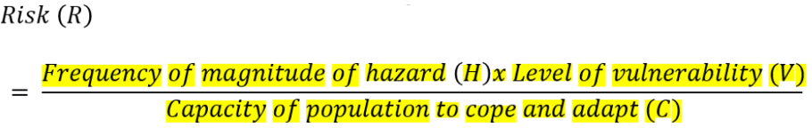
Risk equation:
Shorter-term and longer-term impacts of one earthquake, one volcano, and one tropical cyclone hazard
Earthquake: Haiti (2010)
Short-term:
7.0 magnitude quake near Port-au-Prince.
Over 230,000 deaths and 300,000+ injured.
1.5 million left homeless.
Hospitals, roads, and government buildings collapsed.
Long-term:
Slow reconstruction due to poverty and weak government.
Rise in homelessness and unemployment.
Disease outbreaks (e.g., cholera).
Aid dependency and economic stagnation.
Volcano: Mount Eyjafjallajökull, Iceland (2010)
Short-term:
Eruption caused an ash plume that disrupted air travel across Europe.
Over 100,000 flights cancelled, affecting 10 million passengers.
Local flooding due to glacier melt (jökulhlaup).
Long-term:
Increased tourism due to global attention.
Strengthened monitoring systems and emergency plans.
Economic losses for airlines and European trade temporarily.
Cyclones haiyan, Philippines 2013
Short-term impacts:
Strong winds destroyed homes, power lines, crops
6300 deaths, thousands missing
Storm surge flooded coastal towns
Long-term impacts:
Millions homeless and reliant on aid
Spread of disease due to lack of clean water
Loss of livelihoods (farming, fishing, tourism)
Slow rebuilding of infrastructure and economy
Some countries are more vulnerable (physically, socially and economically) than others to the impacts of natural hazards
Physical vulnerability:
Proximity to coastlines or tectonic boundaries.
Poor terrain for evacuation (e.g., mountainous or isolated).
Poor-quality building materials or structures.
Social vulnerability:
Low levels of education or disaster awareness.
Limited access to healthcare and emergency services.
High population densities in hazard-prone areas (e.g., informal settlements).
Economic vulnerability:
Low GDP and limited resources for preparation and response.
Dependence on agriculture (high risk from flooding/drought).
Inadequate insurance coverage or infrastructure investment.
Case studies of hazard management for an earthquake in a developed country and a developing country
Turkey Syria earthquake:
Background information
A magnitude 7.8 earthquake struck on 6 February 2023, followed by a second powerful aftershock of magnitude 7.5. These were two of the strongest earthquakes to hit the region in over a century.
The epicentre was near Gaziantep, a major city in southern Turkey, close to the Syrian border. The quake impacted a wide area, including Kahramanmaraş, Hatay, and areas of northwestern Syria.
Over 59,000 people died, including more than 50,000 in Turkey and over 8,000 in Syria, making it one of the deadliest disasters in modern Turkish history.
More than 230,000 buildings in Turkey alone were destroyed or severely damaged, including homes, hospitals, and schools.
The earthquake occurred along the East Anatolian Fault, which is known for its tectonic activity due to the collision between the Anatolian, Arabian, and Eurasian plates.
Preparation for earthquakes
Turkey has modern building codes, but enforcement has been inconsistent. Many buildings that collapsed were not constructed to withstand strong seismic activity, even though they were in a known earthquake zone.
Corruption and a lack of regular inspections meant that some developers used substandard materials or ignored regulations.
Syria, already weakened by over a decade of civil war, had minimal capacity for disaster preparation. Damaged infrastructure, limited government control in some areas, and displacement of millions made earthquake readiness nearly impossible.
Early warning systems and public drills were not widespread, especially in rural or war-affected zones.
Short term impacts
Social impacts included mass casualties, with tens of thousands injured and millions left homeless. Families were separated, and thousands of children were orphaned.
Economic impacts were severe, including the destruction of roads, airports, factories, and businesses. The disruption to the supply chain affected goods, services, and fuel availability.
Political impacts emerged quickly, especially in Turkey, where the government faced intense criticism for a slow and disorganised initial response. In Syria, the fractured political landscape and lack of unified governance made coordinated relief very difficult.
Long term impacts
Social impacts continue with millions displaced in temporary shelters. Long-term trauma, mental health problems, and disruption to children's education are ongoing issues.
Economic impacts include an estimated cost of over $100 billion in damages in Turkey. Rebuilding efforts will take years and have slowed national and regional economic growth.
Political impacts include increased public pressure on the Turkish government to improve disaster management. In Syria, the disaster further complicated humanitarian access and deepened the hardship in already vulnerable communities.
Short-Term Relief:
Emergency medical aid shipments: Over 800 tons of medical supplies—including antibiotics, surgical kits, and trauma care items—were delivered to hospitals and mobile clinics in the affected areas.
Financial assistance: Direct Relief provided over $10 million in emergency funding to aid immediate search and rescue operations and support urgent healthcare needs.
Local partnerships: Worked closely with local NGOs such as AKUT and the Syrian American Medical Society to coordinate fast and effective aid delivery.
Support for displaced populations: Distributed hygiene kits, personal care items, and essential supplies to those living in temporary shelters and camps.
Treatment for injuries and chronic illnesses: Ensured availability of critical medications and equipment to address both earthquake-related trauma and ongoing health conditions.
Long-Term Relief:
Mental health support: Funded trauma prevention programs and provided psychosocial support services to help individuals cope with the psychological aftermath.
Mobile rehab services: Deployed mobile physiotherapy units to assist in the rehabilitation of injured survivors, particularly in rural or remote areas.
Ongoing medical aid: Continued sending shipments of medical supplies focused on maternal health, primary care, and support for healthcare workers.
Healthcare infrastructure investment: Supported the rebuilding and strengthening of health systems to improve disaster preparedness and resilience.
Training for local responders: Organized emergency response training for medical professionals and first responders to better equip them for future disasters.
Factors that impacted the response
Freezing winter temperatures made search and rescue more dangerous and increased the risk of hypothermia for survivors.
The scale of the disaster overwhelmed local services and emergency response units.
Damaged infrastructure, including roads and airports, made it difficult to reach remote or heavily damaged areas quickly.
In Syria, political divisions, sanctions, and ongoing war significantly hindered the delivery of aid, especially to opposition-held areas.
How successful was the response
The response saved many lives, especially with the help of international teams and local volunteers.
However, there was widespread criticism of delays in reaching victims, especially in the early days, and a lack of coordination in some regions.
In Syria, access issues and political barriers meant that some areas received very limited assistance.
The disaster exposed serious gaps in preparedness and planning, prompting governments and aid organisations to re-evaluate strategies for future earthquake-prone zones.
Japan 2011 Earthuake and Tsunami:
Background information – location, facts and figures
A magnitude 9.0 undersea megathrust earthquake struck off the northeastern coast of Honshu, Japan, near Sendai, at 2:46 PM (local time) on 11 March 2011.
It was the most powerful earthquake ever recorded in Japan and the fourth largest in the world since modern records began.
The earthquake occurred at a destructive (convergent) plate boundary, where the Pacific Plate is subducting beneath the North American Plate.
It triggered a massive tsunami, with waves reaching up to 40.5 metres (133 feet) and travelling as far as 10 km inland.
The tsunami was responsible for the majority of deaths and destruction.
Over 20,000 people were confirmed dead or missing, and hundreds of thousands were displaced.
The disaster caused a major nuclear accident at the Fukushima Daiichi Power Plant, with radiation leaks and long-term evacuations.
Preparation for earthquakes
Japan is highly earthquake-prone and has some of the world’s most advanced earthquake preparedness, including:
Early warning systems that can give people seconds to act.
Strict building regulations that ensure structures can withstand strong shaking.
Regular public earthquake and tsunami drills, especially in coastal areas.
Despite these measures, the tsunami was far more powerful than expected, overwhelming defences like sea walls in many locations.
Nuclear facilities such as Fukushima had protective measures, but the tsunami knocked out backup power, causing a failure in cooling systems and a radiation release.
Short-term impacts – social, economic, political
Social: Around 16,000 confirmed deaths, more than 6,000 injured, and 2,500 missing. Entire communities along the coast were destroyed, and survivors faced cold weather, trauma, and shortages of food and water.
Economic: Estimated damage was $235 billion, making it the costliest natural disaster in history. Ports, roads, railways, and factories were damaged or destroyed, severely disrupting supply chains.
Political: The government faced criticism for confused communication and delays, particularly concerning evacuation procedures at Fukushima.
Long-term impacts – social, economic, political
Social: Many survivors lived in temporary housing for years. Emotional trauma, PTSD, and increased suicide rates were reported, especially among elderly survivors.
Economic: Long-term economic effects included power shortages and reduced industrial output. Agricultural and seafood exports were affected by fears of contamination.
Political: There was widespread debate over the future of nuclear energy in Japan, leading to the temporary shutdown of all nuclear reactors and stricter regulations.
Short-Term Relief:
Initial funding and medical resources: Set up the Japan Relief and Recovery Fund with $600,000 in startup aid and allocated $15 million in medical inventory for trauma care.
Essential non-food supplies: Delivered necessities like diesel, kerosene, sanitary items, sleeping bags, and batteries to displaced families and relief shelters.
Food distribution: Provided food staples including fruit, rice, milk, and tea to affected communities where access to groceries was cut off.
Shelter support: Assisted local organizations in operating and supplying evacuation centers and temporary shelters for people forced from their homes.
Long-Term Relief:
Funding for Japanese aid groups: Granted over $5.5 million to 13 local NGOs working on sustained recovery and rebuilding initiatives.
Community facility restoration: Helped renovate public spaces such as mobile libraries and community farms to promote social cohesion and economic recovery.
Health and radiation safety: Supported public education on radiation exposure and funded child protection programs related to environmental safety.
Psychological well-being: Invested in mental health initiatives to aid those traumatized by the disaster, especially children and elderly survivors.
Rebuilding for resilience: Helped rebuild safe playgrounds and other communal infrastructure, and strengthened relationships with local groups to improve readiness for future disasters.
What factors impacted the response?
Japan’s preparedness and training helped reduce casualties from the earthquake itself.
However, the scale of the tsunami and nuclear disaster overwhelmed initial responses.
Cold weather, damaged infrastructure, and communication breakdowns slowed down rescue efforts.
The nuclear crisis created fear, confusion, and logistical challenges in evacuation and aid distribution.
How successful was the response?
The earthquake and tsunami response was widely praised, with effective rescue efforts and high levels of international cooperation.
The response to the Fukushima nuclear disaster was more controversial due to early delays, confusion, and lack of transparency.
Japan has since made major improvements to disaster readiness, including stricter nuclear safety laws and better public communication.
Recovery has taken years, and while many communities have been rebuilt, some areas remain uninhabitable due to radiation.
Earthquakes present a hazard to many people and need to be managed carefully
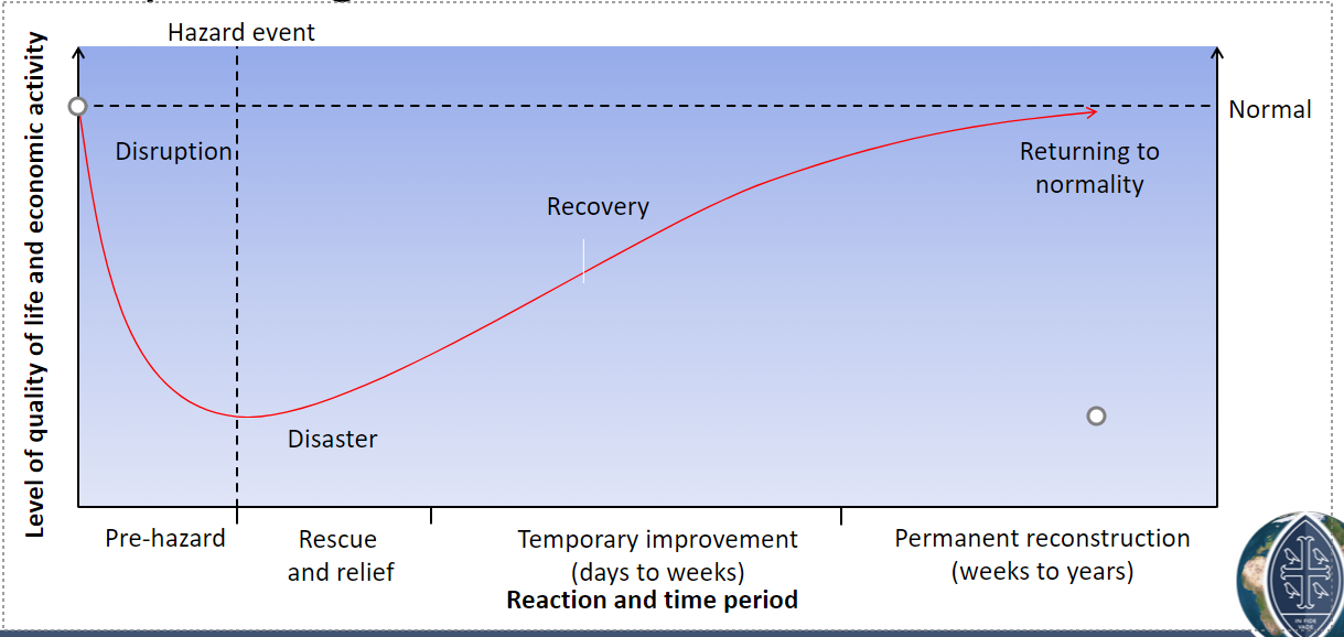
Disaster recovery graphs:
How will a disaster recovery graph differ in a developed country compared to a developing country? -
Developed country:
Level of disaster would be lower due to better infrastructure and possible more previous warning systems
The recovery trajectory would be faster and the return to normality would be sooner
Developing country:
Disaster might be more severe due to no pre warning and less effective yielding infrastructure
The road to recovery would take longer and the recovery line would be slower and more gradual
Preparation for earthquakes (warning and evacuation, building design, remote sensing and GIS)
Early warning systems:
Seismic sensors detect shockwaves and send alerts seconds before shaking.
When an earthquake begins, fast P-waves emanate from the focus
These are detectable byseismometers, it hardly felt by people
Automatic warnings are then sent via TV,radio, the internet, mobile phones giving people up to a minutes warning of destructive S-waves
Japan has a sophisticated nationwide system.
Evacuation and drills:
Regular public drills in high-risk countries (e.g., Japan's Disaster Prevention Day).
Evacuation routes clearly marked in public buildings and schools.
Earthquake-resistant buildings:
Base isolators, flexible steel frames, and cross-bracing absorb shock.
Retrofitting older buildings in high-risk areas.
Remote sensing and GIS:
Use of satellite imagery to monitor changes in land and fault activity.
GIS mapping used to identify high-risk zones and infrastructure vulnerability.
Techonology:
In some countries apps will alert you if an earthquake is expected or you might get a text
Satellite images immediately after an event are increasingly being used to help with rescue operations
GIS paired with remote sensing can provide useful innovation such as location of settlements and areas at risk of landslides.
This helps to understand the degree of risk
Longer-term planning (risk assessment, hazard mapping and rebuilding programmes)
Risk assessment:
Identify vulnerable populations and infrastructure.
Analysis of past events and likelihood of recurrence.
Hazard mapping:
Mapping of active faults and previous earthquake zones.
Used in land-use planning and insurance zones.
Rebuilding programmes:
Reconstruction of infrastructure using quake-resistant design.
Zoning regulations to prevent rebuilding in unsafe areas.
Community resilience training and public education.
Short-term responses and relief (emergency aid, shelter and supplies)
Immediate deployment of rescue teams and paramedics.
Provision of temporary shelters, food, clean water, and sanitation.
Establishment of communication centers for coordination.
Support from international organizations and NGOs.
Use of helicopters, drones, and satellite communication for search and delivery in remote areas.
For cyclones specifically:
Preparation for tropical cyclones
Satellite tracking and monitoring to give warnings
Evacuation routes and shelters in coastal areas
Education programmes to inform people how to respond
Strong building design to withstand winds and flooding
Short-term responses
Emergency aid: food, water, medical care
Temporary shelters for displaced people
Rescue operations after flooding and wind damage
Longer-term planning
Risk assessment and hazard mapping → identify high-risk coastal zones
Coastal defences such as sea walls and mangroves
Rebuilding homes and infrastructure to cyclone-resistant standards
International aid and long-term economic recovery plans
Management to modify loss:
Emergency aid
E.g. bottled water, medical supplies, tents, food packs
Disaster response teams and equipment:
E.g. helicopters and heavy lifting equipment
Search and rescue strategies
Insurance for buildings and businesses
Resources for rebuilding public services
E.g schools and hospitals, and help for individuals to rebuild homes and businesses
Rescue and relief:
Requires a coordinated and well equipped emergency service
Involves:
Releasing people trapped in collapsed buildings
Using lift gear
Restoring basic services
Proving medical help
Distributing. Emergency rations
Who responds:
If the disaster is a major one, it is likely to attract relief from international organisations e.g. UN, Oxfam, Red Cross
HICs less likely to ask for international help
Restoration and rebuilding:
In HICs, most of the restoration/rebuilding is paid for by personal insurance
Governments work often have the capacity to invest and rebuild key infrastructure
Poor countries will often rely on loans from the world bank
Impacts on development
Appraisals and long term planning:
An inquest looking back at the disaster and assessing how well or otherwise the emergency works
It is done to consider whether anything could be done to reduce the impact if a similar event were to happen again
Do the risks need to be reassessed?
Do warning systems need to be improved?
Are evacuation procedures adequate
Can arrangements for delivery of emergency aid be improved?