Living with the Physical Environment
Natural Hazards
A natural hazard is a naturally occurring event that is a threat to a population. Natural hazards negatively affect a population by causing loss of life, injuries, and damage to important infrastructure that people rely on.
Types of Natural Hazard
Geological hazards: hazards caused by the process on the land.
Example: volcanoes, earthquakes, landslides, mudflows
Hydrological hazards: hazards caused by the movement of water on the land.
Example: flooding
Atmospheric hazards: hazards caused by the water.
Example: tropical storms, tornadoes, droughts
Factors affecting Hazard risks
Hazard risk is the probability (i.e. the likelihood or the chance) that a natural hazard will actually affect a population.
The risk a hazard poses is dependent on a population's exposure to the hazard as well as the population's vulnerability to the hazard.
If a population is more exposed to a hazard, then the hazard risk is higher.
For example, if someone lives next to an active volcano, they are at higher risk than someone who lives 100 miles away from the active volcano.
If a population is more vulnerable to the hazard (meaning they lack the resources to deal with the effects of a hazard) the risk is also higher.
For example, if a population has poor access to healthcare or rescue services, they are at a higher risk of the hazard affecting the population.
Tectonic Hazards
Plate Tectonic Theory
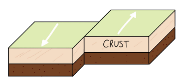
The word tectonic refers to the structure of the Earth's crust, the outside layer of the Earth. The crust is broken up into huge slabs of rock called tectonic plates.
The physical processes that these tectonic plates undergo cause movements within the Earth, which - in turn - create earthquakes and volcanic eruptions.
These hazards are therefore referred to as tectonic hazards.
As previously mentioned, the Earth's crust is split up into multiple large slabs called tectonic plates.
These plates range from tens to hundreds of kilometers thick, and are either classed as continental crust which makes up our land (old, less dense and thick) or oceanic crust which makes up the ocean floor (younger - but still very old! - dense and thin).
Plates move due to the movement of the liquid magma deep within the Earth. The movement of magma creates convection currents, which are flows of heat.
Below is a diagram of how convection currents work inside the Earth:
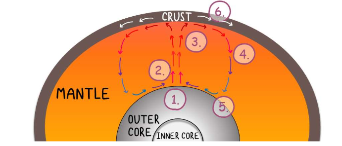
The core heats up the magma in the mantle
The hot magma is less dense than its surroundings, so it rises upwards
When it reaches the top, it cools
It becomes more dense, and therefore sinks back down to the bottom
It is heated up again, and the cycle continues
The plates, which lie on top, are pushed and pulled by the convection currents in the magma
Tectonic plates move very slowly in relation to each other and in different directions. They move next to each other, towards each other, away from each other, and sometimes they can be pushed over and under one another.
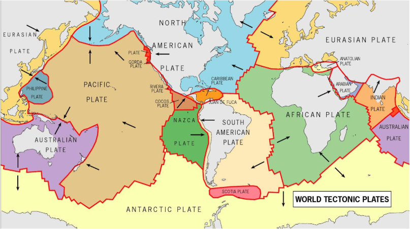
The global distribution of plates can be seen below. Where the plates meet - indicated in red - is known as a plate margin.
The arrows indicate the direction that the plates are moving.
The Global Distribution of Tectonic Hazards
Tectonic hazards occur on plate margins.
There is a clear pattern of volcano and earthquake distribution along plate margins, such as along the west of North America and South America, or in the Atlantic Ocean between Africa and South America.
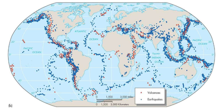
An example of an area with high volcanic and earthquake activity is The Ring of Fire, which is located in the Pacific Ocean.
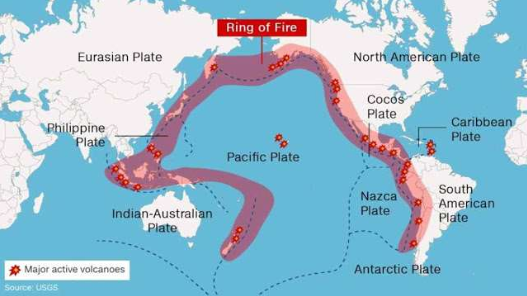
The earthquakes and volcanoes follow the margins between the Pacific tectonic plate and other plates.
Earthquakes occur along plate margins due to plate movements causing vibrations.
Volcanoes occur along certain plate margins as magma (molten rock found underground) feeds volcanoes, and this magma can get to the surface at certain plate margins.
Volcanoes do not always occur on plate margins (like in the middle of the Pacific Plate shown in the map above).
This is where the magma breaks through the middle of the plate and travels up to the surface, which is known as a hotspot.
Plate Margin Processes
Plate margins interact in different ways depending on the direction they are moving in relation to each other.
This controls the types of landforms that are created at margins, as well as the type of tectonic hazard generated.
Three types of plate margin:
Constructive - Plates move away from each other.
Destructive - Plates move towards each other.
Conservative - Plates move alongside each other.
Constructive Plate Margins
At a constructive plate margin, the plates are moving away from each other.
When the two plates are pulled apart, magma rises in between the gap left by the two plates separating.
Lava (when magma is above ground, it is classed as lava) then pours out onto the surface.
Volcanoes form in the areas where lava pours out.
This lava is usually runny and free-flowing, which creates flatter volcanoes. Earthquakes also occur here as the plates shake and vibrate when they move apart.
This process can happen on continental crust (left) or oceanic crust (right).
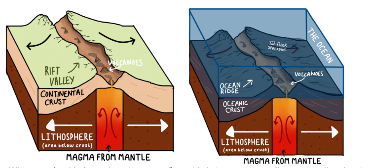
When new land is formed on the ocean floor, this is known as sea floor spreading (as the floor spreads and gets wider).
When lava cools, it forms rock.
Over time, this rock builds up and can form islands, for example Iceland is a volcanic island.
Iceland sits on the Mid-Atlantic ridge, which is where the lava pours out from.
Destructive Plate Margins
At a destructive plate margin, the plates move towards each other.
This causes one of the plates to subduct (sink) below the other into the mantle, where it is destroyed.
In the diagram below, oceanic crust is moving towards continental crust.
This is happening off the west coast of South America where the Nazca Plate is subducting below the South American Plate.
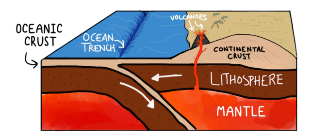
Destructive plate margins cause earthquakes and volcanoes due to the following processes:
The denser oceanic crust is subducted below the continental crust
The plate that is subducting leaves a deep ocean trench
Friction between the two plates causes strong, deep earthquakes
The oceanic crust is melted as it is pulled deeper into the mantle, creating magma.
This magma causes pressure to build up under the crust.
Eventually the magma pushes out through weaknesses in the crust, creating explosive volcanoes.
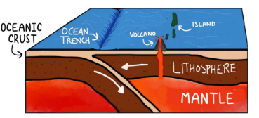
This process can also happen between two oceanic crust plates, where the denser plate sinks below and islands in the ocean can form.
For example, the Mariana trench.
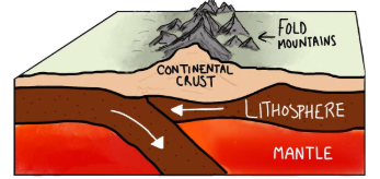
When two continental plates meet, neither plate can subduct below the other.
The crust is instead crumpled upwards by the pressure building between two plates, creating fold mountains.
An example of this is the Himalayas, which formed due to the Indian Plate and Eurasian Plate colliding.
Conservative Plate Margins
At a conservative plate margin, parallel plates move in different directions or at different speeds in relation to each other.
When these plates move side by side, friction builds between the plates.
The friction builds up over many years, and eventually the pressure becomes so large that the plates eventually move in a sudden jolt.
This releases a lot of energy which sends vibrations through the ground. This is an earthquake.
On oceanic crust, this movement can displace a lot of water, which causes large waves
called tsunamis.
On continental crust, fault lines can occur where the ground is cracked by the movement.
There are no volcanoes on conservative plate margins because no magma is being generated.
The Effects of Tectonic Hazards
Primary effects: The effects that are directly caused by the natural hazard itself.
For example, people being killed or injured when an earthquake causes buildings to fall down, or lava and ash damaging infrastructure.
Secondary effects: The effects that are a result of the primary effects.
For example, homelessness due to homes being destroyed, or a tsunami or landslide caused by the original earthquake.
The Responses to Tectonic Hazards
The term 'responses' refers to how the local community, the government, and international organizations/governments react to a hazard so that the effects can be reduced as much as possible. Responses are either classed as immediate or long-term.
Immediate responses: Actions taken as soon as the hazard happens and in its immediate aftermath (hours, days, and potentially a week or so after the event).
Immediate responses usually aim to reduce loss of life and provide vital aid and resources.
For example: search and rescue, medical care, food and water, shelters for those who have lost their homes.
Long-term responses: Actions taken after the immediate responses when the effects of the hazard have been minimized (weeks, months, and years after the event).
Long-term responses aim to restore normality and reduce risk in the future.
For example: rebuilding infrastructure and homes, cleaning up the effects of the hazard, building defense mechanisms, setting up warning systems.
Reasons why people continue to live in Hazardous Places
The benefits that Tectonic Hazards Bring
Volcanic eruptions disperse ash and debris, rich in nutrients, onto surrounding lands.
As these materials settle, they enrich the soil, making it highly fertile.
This fertility supports thriving agriculture, which becomes a significant source of income for residents.
Consequently, people are drawn to these areas for the economic opportunities afforded by farming on volcanic soil.
Hazards are Monitored and Managed.
Advancements in monitoring technology for tectonic hazards allow for the development of warning systems.
These systems can detect precursors to events like volcanic eruptions (such as bulging, seismic activity, and steam) or large ocean earthquakes that may trigger tsunamis.
With the ability to provide timely alerts, people living in hazardous areas are more likely to stay, confident that risks can be mitigated through evacuation protocols and early warnings.
Infrequency of Tectonic Events.
Despite being located near tectonic margins where hazards like earthquakes are a possibility, some of the world's largest cities, such as Osaka, San Francisco, and Manila, thrive due to their rich cultural and lifestyle offerings.
Infrequent occurrences of tectonic hazards lead many residents to overlook the risks, especially when hazards like major earthquakes may not have been experienced in recent memory.
For some, the benefits of their area's lifestyle and culture outweigh the perceived risks associated with tectonic hazards, especially if the likelihood of such events happening within their lifetime is considered low.
Hazard Management
Monitoring - detecting and recording physical changes and warning signs.
Predicting - using monitoring as well as historical trends and computer based modeling to predict when a tectonic event may occur.
Protecting - increasing the resistance of a pollution to tectonic hazards by physically designing things that will withstand tectonic hazards.
Planning - having systems in place, such as evacuation routes, so that if an event does occur, the population is prepared in advance.
Weather Hazards
Global Atmospheric Circulation
The way our atmosphere circulates around the Earth impacts global weather and climate patterns, as the movement of air around the globe influences the temperature and humidity.
Atmospheric Circulation: The atmosphere is the layer of air surrounding the Earth's surface which extends hundreds of kilometers high.
Global Atmospheric Circulation Model
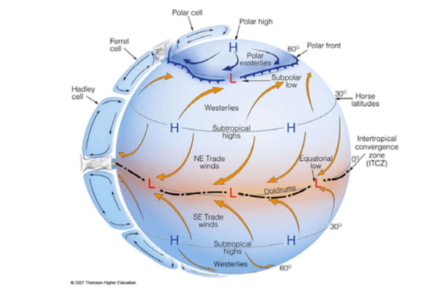
The three cells are:
The Hadley Cell: At the equator, hot, moist air rises, moves to higher latitudes (30") and sinks.
The Ferrel Cell: At around 60° either side of the equator, moist air rises, any travels to lower latitudes at around 30° where it sinks, along with air traveling from the equator.
The Polar Cell: At 60° north or south of the equator, moist air rises, and travels to the poles (90°), where it sinks.’
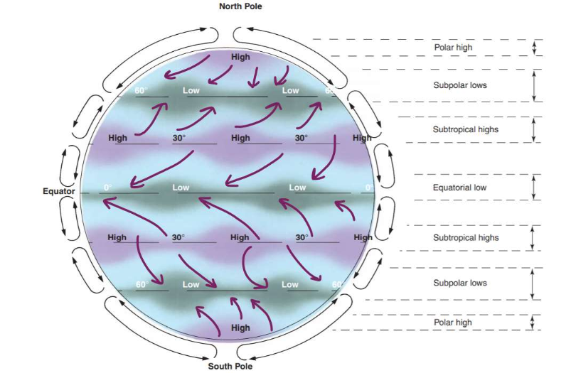
Pressure Belts
These air circulations create different areas of pressure.
When air rises, it creates an area of low pressure underneath.
When air sinks, it creates an area of high pressure.
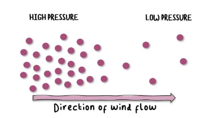
Wind
Wind is created when air particles move. Air particles will always move from an area of HIGH PRESSURE to an area of LOW PRESSURE.
Coriolis Effect: Because the Earth rotates on its axis, circulating air is deflected toward the right in the Northern Hemisphere and toward the left in the Southern Hemisphere.
Atmospheric Circulation affects Climate and Weather
Climate at the Equator
The sun shines directly on the equator, meaning it is consistently warmer than - for example - at the poles where the sunlight is less direct.
Hot, moist air rises here, creating an area of low pressure (equatorial low).
When the moist air rises, it condenses to form rain clouds. This causes the climate at the equator to be humid and very rainy.
Tropical rainforests are found here due to the warm and wet weather.
Climate at the Subtropics
Dry air sinks at the subtropics, meaning it forms an area of high pressure.
Clouds do not form here because the air isn't rising, so it is very dry.
This is where we find many of the world's deserts.
It is very hot in the day because of the intense sunlight, but very cold at night because there are no clouds to retain heat.
Climate at Subpolar Latitudes
At around 60° north or south of the equator there is a low pressure belt, causing the climate to be cloudy and wet.
The climate here is not as warm as the sun shines less directly than at the equator.
Tropical Storms
A tropical storm is a very large, spinning storm that forms in the tropics.
Tropical storms have high winds and torrential rain, and usually affect small islands and coastal regions.
Causes of Tropical Storms
Temperature: Ocean temperatures must be around 26 - 27°C and at least 50 metres deep.
Warm water provides the storm with energy.
This is why storms form during late summer, when the ocean has had time to heat up.
Air pressure: Must be in areas of unstable air pressure - usually where areas of high pressure and low pressure meet - so that warm air rises more readily and clouds can form (this air must also be humid for cloud formation).
Warm air rises because it is less dense than cold air.
Wind shear: Winds must be present for the swirling motion to form, but not too strong or the storm system will be ripped apart in the early stages.
Rotation: Tropical storms only form around the equator, between 5-30° either side of the equator, but tropical storms will not form on the equator.
The Coriolis Effect is the effect of the Earth's rotation on weather events.
The storm spins because the Earth is spinning; but there is no Coriolis Effect at the equator, hence why these storms will only form a certain distance away from it.
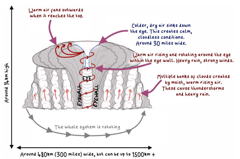
Tropical Storm Formation
Warm, moist air rises, leaving an area of low pressure below. This causes warm air from the surroundings to move into this low pressure area and rise too. Overall, warm air is constantly rising and accumulating in the atmosphere.
When the warm air rises, it eventually cools. This moist air will then condense and form large thunderstorm clouds.
The whole system is spinning due to the Coriolis effect. In the southern hemisphere, the storms spin clockwise; in the northern, anticlockwise.
The constant additions of energy from the warm air causes the storm to spin faster and generate higher wind speeds. At 75 mph the storm can be classed as a category 1 tropical storm.
The storm develops an eye in the center. This is an area of extremely low pressure where cool, dry air descends. The weather within the eye is relatively calm and cloud free. Surrounding the eye is the eyewall, the most intense and powerful area of the storm. Warm, moist air rapidly rises here, with extremely high winds and torrential rain.
When the tropical storm reaches a coast, the low pressure and high winds will cause a large amount of sea water to be pushed onto the coast, which is called a storm surge. When the storm reaches land, it no longer has a supply of energy (warm, moist air from the sea) and the eye eventually collapses and the storm dissipates. Heavy rain can persist for days.
Tropical Storm Structure
Effects of Climate Change on Tropical Storms
Distribution refers to where the tropical storms are formed, and where they move to.
Frequency refers to the number of tropical storms.
The intensity of a tropical storm is how much power the tropical storm has (e.g. its wind speed) which is measured using a scale of 1-5. Category 1 is the lowest intensity, Category 5 is the highest intensity.
Effects of Tropical Storms
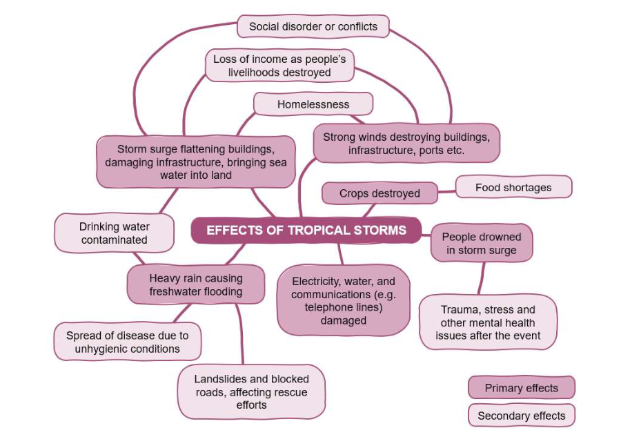
Primary effects: The effects that are directly caused by the tropical storm itself.
For example, strong winds knocking over power lines.
Secondary effects: The effects that are a result of the primary effects.
For example, landslides caused by flooding.
The Responses to Tropical Storms
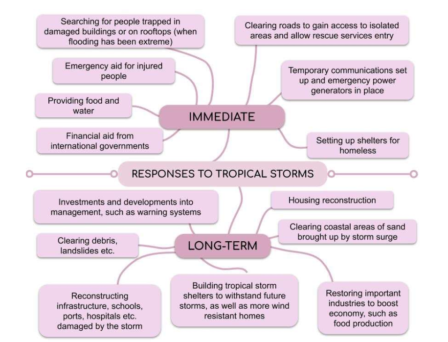
Tropical Storm Management
Monitoring: detecting and recording warning signs of storm formation and movement
Predicting: using monitoring as well as historical trends and computer based modelling to predict where the tropical storm will hit, when it will hit, and the duration of the storm.
Protecting: Increasing the resistance of a population to the tropical storm by physically designing things that will withstand the effects.
Planning: Having systems in place, such as evacuation routes, so that if a tropical storm does occur, the population is prepared in advance.
Weather Hazards in UK
When we talk about the weather of a place, we are usually referring to the daily conditions that a place experiences, such as the temperature, how windy it is, how much cloud cover there is/ how sunny it is, and if there's any precipitation (rain, snow, hail etc.).
Types of Weather Hazards:
Prolonged rainfall
Thunderstorms
Extreme cold and Heavy snow
Strong winds
Droughts and extreme heat
Climate Change
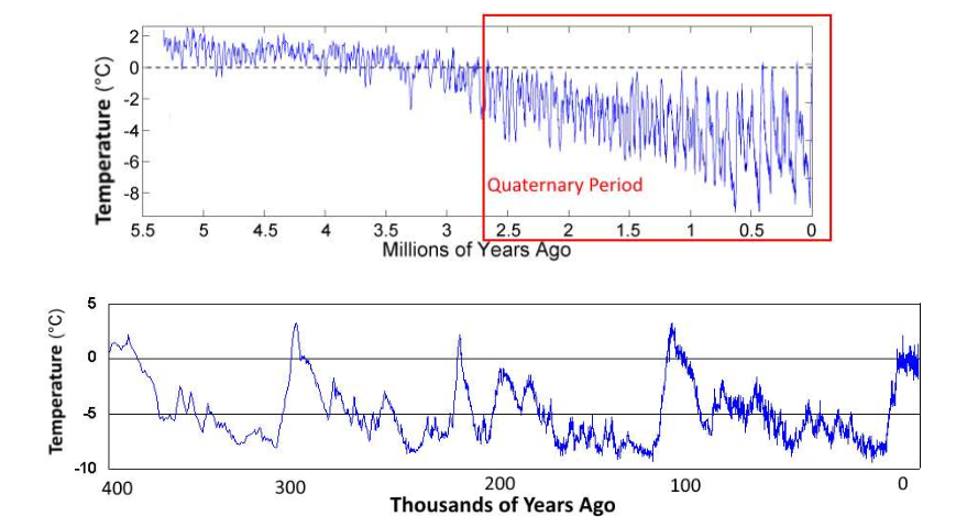
During Earth’s History
When we hear the phrase 'climate change', we might think about the changes in our climate over the last few decades: rising temperatures in the air and the sea, more intense tropical storms, severe droughts etc.
However, the climate of the Earth has gone through dramatic changes throughout its history.
Some major fluctuations in temperature have occurred in the Quaternary Period.
The Quaternary Period is the geological time period that started 2.6 million years ago, and extends into the present.
During the Quaternary period, there have been many fluctuations between the colder glacial periods and warmer interglacial periods.
Current Evidence of Climate Change
Sea Level Rise: Sea level rise is one of the most visible and measurable impacts of climate change.
It occurs primarily due to two factors: thermal expansion of seawater and the melting of land-based ice (such as glaciers and ice sheets).
As global temperatures increase, polar ice caps and glaciers melt at accelerated rates, contributing significantly to rising sea levels.
Additionally, warmer temperatures cause seawater to expand, further elevating sea levels.
This rise in sea level poses a significant threat to coastal communities, leading to increased flooding, erosion, and saltwater intrusion into freshwater sources.
Decay of Glaciers: Glaciers are large masses of ice that move slowly over land surfaces, sculpting landscapes and feeding freshwater systems.
Climate change has led to the rapid melting and retreat of glaciers worldwide. Increased temperatures cause glaciers to lose more mass through melting than they gain through snowfall, resulting in net mass loss.
This phenomenon is observed across various regions, from the Arctic to the Himalayas.
The decay of glaciers has profound implications for water resources, ecosystems, and human activities dependent on glacial meltwater, such as agriculture and hydropower generation.
Additionally, the loss of glaciers contributes to rising sea levels.
Changes in Ecological Patterns: Climate change is disrupting ecosystems and altering ecological patterns in numerous ways.
One significant impact is shifts in the distribution and abundance of species.
Warmer temperatures can force species to migrate poleward or to higher elevations in search of suitable habitats, leading to changes in species composition and biodiversity.
Additionally, altered precipitation patterns affect vegetation dynamics, leading to changes in forest composition, range shifts in plant species, and increased risk of wildfires in some regions.
Changes in ecological patterns can have cascading effects on ecosystem services, such as pollination, nutrient cycling, and water purification, with implications for human well-being and livelihoods.
Natural Causes of Climate Change
Orbital Changes: Earth's orbit around the Sun undergoes cyclic variations over long periods, affecting the distribution of solar radiation received by different parts of the planet.
There are three primary orbital parameters that influence climate: eccentricity, obliquity, and precession.
Eccentricity: Eccentricity refers to the shape of Earth's orbit around the Sun.
It varies over a cycle of about 100,000 years, transitioning between more circular and more elliptical orbits.
When the orbit is more elliptical, there are greater seasonal temperature differences, potentially impacting climate patterns.
Obliquity: Obliquity, or axial tilt, refers to the angle between Earth's rotational axis and its orbital plane.
This angle varies between approximately 22.1 and 24.5 degrees over a cycle of about 41,000 years.
Changes in obliquity can influence the severity of seasons, with higher obliquity leading to more extreme seasons.
Precession: Precession refers to the wobbling motion of Earth's axis of rotation, which gradually changes the orientation of the axis relative to the fixed stars.
This motion operates on a cycle of about 26,000 years and affects the timing of seasons in different hemispheres.
Solar Output: Variations in the Sun's energy output, known as solar irradiance, can influence Earth's climate.
While the Sun's energy output is relatively stable over short timescales, it undergoes small fluctuations over longer periods.
These fluctuations can impact climate variability, though their effects are generally smaller compared to other factors.
Volcanic Activity: Volcanic eruptions can have significant short-term effects on climate. When volcanoes erupt, they release large amounts of ash, gases (such as sulfur dioxide), and aerosols into the atmosphere.
These particles can reflect sunlight back into space, leading to a temporary cooling effect on the Earth's surface.
Additionally, sulfur dioxide can react with water vapor to form sulfate aerosols, which can linger in the atmosphere for months to years, further contributing to cooling.
Human Causes of Climate Change
The Greenhouse Effect: The greenhouse effect is a natural process whereby certain gases in the Earth's atmosphere trap heat from the Sun, preventing it from escaping back into space and thereby warming the planet's surface.
Without the greenhouse effect, Earth would be much colder and less hospitable to life.
However, human activities, particularly the burning of fossil fuels and deforestation, have intensified this effect by increasing the concentration of greenhouse gases in the atmosphere.
The Enhanced Greenhouse Effect: The enhanced greenhouse effect refers to the intensification of the natural greenhouse effect due to human activities.
By burning fossil fuels such as coal, oil, and natural gas for energy, humans release large amounts of carbon dioxide (CO2) and other greenhouse gases into the atmosphere.
These gases trap more heat than would occur naturally, leading to global warming and associated climate changes.
Fossil Fuels: The burning of fossil fuels for energy production is the largest single contributor to human-caused climate change.
When fossil fuels are burned for electricity, transportation, heating, and industrial processes, they release carbon dioxide (CO2) and other greenhouse gases into the atmosphere.
The combustion of coal, oil, and natural gas accounts for the majority of anthropogenic CO2 emissions.
Agriculture: Agriculture is another significant contributor to climate change, primarily through the production of methane (CH4) and nitrous oxide (N2O), both potent greenhouse gases.
Activities such as rice farming, livestock production, and the use of synthetic fertilizers release methane and nitrous oxide into the atmosphere.
Rice Farming: In flooded rice paddies, anaerobic conditions promote the production of methane by microorganisms. Methane is then released into the atmosphere during the growth and harvesting of rice crops, contributing to global warming.
Livestock: Ruminant animals such as cows and sheep produce methane as a byproduct of their digestive processes. Additionally, manure management and livestock feed production also contribute to methane and nitrous oxide emissions.
Deforestation: Deforestation, primarily for agricultural expansion, logging, and urban development, releases large amounts of carbon stored in trees and forest soils into the atmosphere as CO2.
Forests act as carbon sinks, absorbing CO2 through photosynthesis and storing it in biomass and soil.
When forests are cleared or degraded, this carbon is released, contributing to increased greenhouse gas concentrations in the atmosphere.
Greenhouse Gas Levels and Climate Change: The accumulation of greenhouse gases in the atmosphere, particularly CO2, methane, and nitrous oxide, has led to a rise in global average temperatures, changes in precipitation patterns, melting ice caps and glaciers, rising sea levels, and other impacts associated with climate change.
These changes pose significant risks to ecosystems, biodiversity, human health, and socio-economic systems worldwide.
Effects of Climate Change
Rising Temperatures: Global average temperatures have been increasing, leading to more frequent and intense heat waves.
Higher temperatures can have detrimental effects on human health, agricultural productivity, and ecosystems, including increased heat-related illnesses, reduced crop yields, and stress on wildlife and plant species.
Extreme Weather Events: Climate change is linked to an increase in the frequency and severity of extreme weather events, such as hurricanes, droughts, floods, and wildfires.
These events can cause widespread destruction of infrastructure, loss of life, displacement of communities, and disruption of food and water supplies.
Melting Ice Caps and Glaciers: Rising temperatures have accelerated the melting of ice caps and glaciers, particularly in polar regions.
This contributes to rising sea levels, threatening coastal communities with flooding and erosion, and disrupting marine ecosystems and habitats.
Sea Level Rise: As ice caps and glaciers melt and ocean waters expand due to warmer temperatures, sea levels are rising globally.
This poses a significant risk to low-lying coastal areas, increasing the frequency of coastal flooding, storm surges, and saltwater intrusion into freshwater sources.
Ocean Acidification: Increased levels of carbon dioxide (CO2) in the atmosphere are being absorbed by the world's oceans, leading to ocean acidification.
This can harm marine life, particularly shell-forming organisms like corals, mollusks, and plankton, with cascading effects on marine ecosystems and fisheries.
Shifts in Ecosystems: Climate change is causing shifts in the distribution and abundance of species, disrupting ecosystems and altering ecological relationships.
Some species may migrate to higher latitudes or elevations in search of suitable habitats, while others may face extinction due to habitat loss or reduced food availability.
Impacts on Agriculture and Food Security: Changes in temperature and precipitation patterns can affect crop yields, livestock productivity, and food availability.
Shifts in growing seasons, increased pest and disease pressure, and water scarcity pose challenges to agricultural systems, jeopardizing food security for vulnerable populations.
Health Risks: Climate change exacerbates various health risks, including heat-related illnesses, respiratory problems from air pollution, waterborne diseases from flooding, and vector-borne diseases like malaria and dengue fever spreading to new regions.
Vulnerable populations, such as children, the elderly, and those living in poverty, are particularly at risk.
Economic Impacts: The impacts of climate change can have significant economic consequences, including damage to infrastructure, disruptions to supply chains, increased healthcare costs, loss of livelihoods in sectors like agriculture and tourism, and challenges for insurance and financial markets.
Managing Climate Change
Mitigation:
Carbon Capture: Carbon capture and storage (CCS) technologies involve capturing carbon dioxide (CO2) emissions from industrial processes or directly from the atmosphere and storing it underground or using it for other purposes.
CCS can help reduce emissions from sources like power plants, cement factories, and industrial facilities, thereby mitigating climate change.
Tree Planting: Afforestation (planting trees in areas that were previously forested) and reforestation (restoring forests in areas that have been deforested) can help sequester carbon dioxide from the atmosphere through photosynthesis.
Forests act as carbon sinks, absorbing CO2 and storing it in biomass and soil, thereby mitigating climate change and providing other ecosystem benefits such as biodiversity conservation and soil conservation.
International Agreements: International agreements, such as the Paris Agreement under the United Nations Framework Convention on Climate Change (UNFCCC), aim to facilitate global cooperation in addressing climate change.
These agreements set targets for reducing greenhouse gas emissions, promote technology transfer and financial assistance to developing countries, and establish mechanisms for monitoring and reporting progress on climate action.
Adaptation:
Changing Agricultural Systems: Climate change poses challenges to agriculture due to shifting temperature and precipitation patterns, increased pest and disease pressure, and water scarcity.
Adaptation strategies include developing drought-resistant crop varieties, implementing water-efficient irrigation techniques, practicing agroforestry to enhance resilience, and diversifying agricultural practices to reduce vulnerability to climate impacts.
Water Supply Management: Climate change can affect water availability and quality, leading to increased competition for water resources among different sectors and regions.
Adaptation measures include improving water efficiency and conservation practices, investing in water infrastructure and storage facilities, implementing rainwater harvesting and groundwater recharge systems, and enhancing water governance and cooperation mechanisms.
Managing Sea Level Rise: Rising sea levels pose significant risks to coastal communities, infrastructure, and ecosystems.
Adaptation strategies include implementing coastal protection measures such as seawalls, dikes, and beach nourishment, restoring coastal wetlands and mangroves to provide natural buffers against storm surges, regulating coastal development and land use to minimize exposure to sea level rise, and planning for managed retreat in areas that are most vulnerable to inundation.
Ecosystems
An ecosystem is a natural system in which a community of plants and animals interact with each other and their physical environment.
Interactions: Ecosystems involve interactions between:
Biotic Components: Living organisms, such as plants and animals.
Abiotic Components: Non-living environmental factors like climate (temperature, humidity, precipitation), light exposure, soil type, etc.
Scales of Ecosystems:
Small-scale Ecosystems: Local ecosystems, such as those found in a freshwater pond or on the seashore.
Global-scale Ecosystems: Large regions of the world with similar environmental conditions (especially climate, vegetation, and soil type). These are referred to as biomes.
Energy Flow: Ecosystems consist of different organisms that produce and transfer energy through the system.
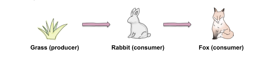
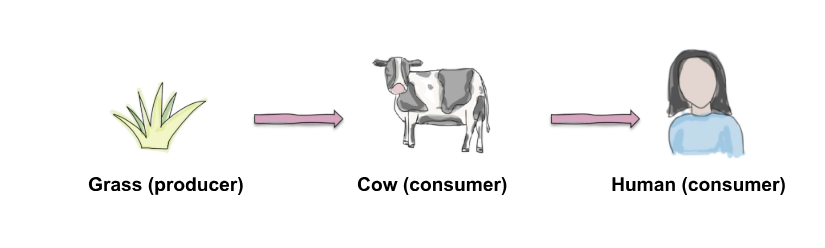
Producers
Definition: Organisms that convert energy from the environment (mainly sunlight) into sugars (glucose).
Process: This conversion happens through photosynthesis.
Example: Plants are primary producers as they use sunlight to produce glucose.
Consumers
Definition: Organisms that receive energy by consuming (eating) living organisms.
Types of Consumers:
Primary Consumers: These eat producers.
Example: Rabbits eat grass (a producer).
Secondary Consumers: These eat primary consumers.
Example: Foxes eat rabbits (primary consumers).
Energy Source: Consumers get their energy either from producers directly or by consuming other consumers.
Decomposers
Definition: Organisms that break down organic material (e.g., dead plants and animals or feces) and release the nutrients back into the soil.
Role in Ecosystem: These nutrients are then absorbed by plants, facilitating growth.
Examples: Fungi and bacteria are primary decomposers.
Food Chains
A food chain represents the linear flow of energy and nutrients through an ecosystem, demonstrating how each organism feeds on the one below it and is, in turn, preyed upon by the one above it.
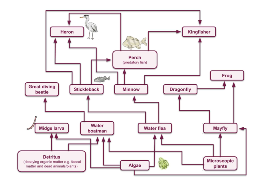
Food Webs
Food webs provide a more comprehensive and realistic depiction of energy flow and nutrient cycling in an ecosystem compared to food chains.
They illustrate the complex interconnections among various organisms, highlighting how multiple food chains interlink.
Nutrient Cycling
Nutrient cycling is the process by which nutrients move through an ecosystem, cycling between the biotic (living) and abiotic (non-living) components.
This process is crucial for sustaining life, as it ensures that essential elements are recycled and made available for use by different organisms.
Carbon Cycle
Photosynthesis: Plants, algae, and cyanobacteria absorb carbon dioxide (CO₂) from the atmosphere and convert it into organic matter using sunlight.
Respiration: Organisms (plants, animals, microbes) break down organic matter, releasing CO₂ back into the atmosphere.
Decomposition: Decomposers (bacteria, fungi) break down dead organisms, returning carbon to the soil and atmosphere.
Combustion: Burning of fossil fuels and biomass releases stored carbon as CO₂.
Nitrogen Cycle
Nitrogen Fixation: Conversion of atmospheric nitrogen (N₂) into ammonia (NH₃) or related compounds by nitrogen-fixing bacteria and archaea, often in association with plant roots.
Nitrification: Conversion of ammonia to nitrite (NO₂⁻) and then to nitrate (NO₃⁻) by nitrifying bacteria.
Assimilation: Plants absorb nitrate and ammonia from the soil and incorporate them into organic molecules.
Ammonification: Decomposition of organic nitrogen back into ammonia by decomposers.
Denitrification: Conversion of nitrate back to N₂ gas by denitrifying bacteria, releasing it into the atmosphere.
Phosphorus Cycle
Weathering: Phosphorus is released from rocks and minerals through weathering processes and becomes available in soil and water.
Absorption: Plants absorb inorganic phosphate from the soil.
Incorporation: Phosphorus is incorporated into organic molecules like DNA, RNA, and ATP.
Decomposition: Decomposers break down organic matter, releasing phosphate back into the soil.
Sedimentation: Phosphorus can precipitate out of water and form sedimentary rock, which may eventually be uplifted and weathered again.
Water Cycle (Hydrological Cycle)
Evaporation: Water evaporates from surface water bodies and soil into the atmosphere.
Transpiration: Plants release water vapor into the atmosphere through small openings called stomata.
Condensation: Water vapor in the atmosphere cools and condenses to form clouds.
Precipitation: Water returns to the Earth as rain, snow, sleet, or hail.
Runoff and Infiltration: Water flows over land into water bodies or infiltrates into the soil to replenish groundwater.
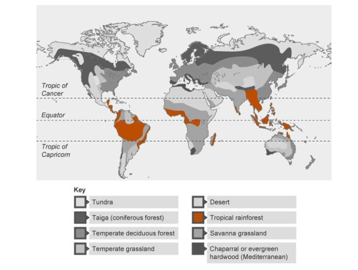
Global Ecosystems
Global ecosystems, also known as biomes, are large-scale ecological units that represent the major types of natural communities found on Earth.
Each biome is characterized by distinct climate conditions, flora, and fauna, which together form a unique environment.
Climate:
The primary determinant of the type of biome found in a particular region.
Temperature, precipitation, and seasonal variations influence the kinds of plants and animals that can thrive there.
Geography:
Includes the latitude, altitude, and geographic features (such as mountains, oceans, and rivers) that affect climate and, consequently, the types of ecosystems present.
Biodiversity:
Each biome supports a specific set of species that have adapted to the environmental conditions.
Biodiversity within biomes contributes to the stability and resilience of ecosystems.
Interdependence:
Within each biome, species interact with each other and with their physical environment, forming complex food webs and nutrient cycles that maintain ecosystem health and functionality.
Major Types of Global Ecosystems (Biomes)
Tropical Rainforests:
Location: Near the equator (e.g., Amazon Basin, Congo Basin).
Climate: Warm and wet year-round with high rainfall.
Flora and Fauna: Dense, diverse vegetation; numerous animal species including insects, birds, and mammals.
Savannas:
Location: Tropical and subtropical regions (e.g., African savannas, Brazilian cerrado).
Climate: Warm with distinct wet and dry seasons.
Flora and Fauna: Grasslands with scattered trees; large herbivores like elephants and predators like lions.
Deserts:
Location: Around 30° latitude north and south (e.g., Sahara, Arabian Desert).
Climate: Very low rainfall, extreme temperatures.
Flora and Fauna: Sparse vegetation; adapted species like cacti, reptiles, and small mammals.
Temperate Forests:
Location: Mid-latitude regions (e.g., Eastern North America, Europe).
Climate: Moderate rainfall, distinct seasons.
Flora and Fauna: Deciduous and coniferous trees; diverse animal species including deer, birds, and insects.
Grasslands (Prairies/Steppes):
Location: Interior continents (e.g., North American prairies, Eurasian steppes).
Climate: Moderate rainfall, can be seasonal.
Flora and Fauna: Dominated by grasses; herbivores like bison and predators like wolves.
Taiga (Boreal Forests):
Location: Northern latitudes (e.g., Canada, Russia).
Climate: Long, cold winters; short, mild summers.
Flora and Fauna: Coniferous trees; animals like moose, bears, and lynxes.
Tundra:
Location: Arctic regions and high mountain tops.
Climate: Very cold, low precipitation, short growing seasons.
Flora and Fauna: Low-lying vegetation like mosses and lichens; adapted animals like caribou and arctic foxes.
Mediterranean:
Location: Mediterranean Basin, parts of California, Chile, South Africa, and Australia.
Climate: Mild, wet winters and hot, dry summers.
Flora and Fauna: Evergreen shrubs, drought-resistant plants; diverse animal species.
Aquatic Biomes:
Marine: Oceans, coral reefs, and estuaries with distinct zones (intertidal, pelagic, abyssal).
Freshwater: Lakes, rivers, wetlands with varied ecosystems depending on water flow and nutrient availability.
Tropical Rainforests
Definition:
A warm, wet ecosystem.
Located within the Tropics (between the Tropic of Cancer and the Tropic of Capricorn).
Amazon Rainforest:
The world's largest rainforest.
Known for its lush, dense vegetation typical of rainforests.
Distribution of Tropical Rainforest
Tropical Rainforest Characteristics
Climate Characteristics
Rainfall
Extremely High Rainfall: Tropical rainforests are among the wettest biomes in the world.
Annual Rainfall: Exceeds 2000 mm per year, more than double the rainfall the UK receives.
Seasonal Rainfall: Distinct wet season with monthly rainfall often exceeding 200 mm.
Humidity: Tropical rainforests are very humid due to the high amount of rainfall.
Temperature
High Temperatures: Around 26-27°C.
Consistent Temperatures: Little seasonal variation, staying consistent throughout the year.
Equatorial Sun: High and consistent temperatures are due to the sun shining directly on the equator year-round.
Plant and Animal Characteristics
High Biodiversity: Over half of the world's plant and animal species are found in tropical rainforests.
Upper Canopy:
Home to birds and flowers.
Characterized by very tall, fast-growing trees.
Canopy:
Inhabited by mammals such as monkeys and sloths.
Understory:
Located beneath the canopy.
Habitat for insects, snakes, frogs, and other animals, which stay away from predators on the forest floor.
Some predators, like jaguars, also hunt in this layer.
Forest Floor:
Inhabited by rodents, larger mammals, and decomposers like fungi.
Rich in decaying organic matter.
Plant Adaptations
Buttress roots
Buttress roots are large, above-ground roots that form ridges at the bases of large tropical trees.
Adaptation:
These roots are an adaptation to nutrient-deprived, waterlogged soils.
They allow trees to remain stable without the need to grow roots deep into the soil.
Function:
Stability: Buttress roots keep tall trees stable.
Air Supply: Being above ground ensures the roots receive enough air.
Leaf Structure
Drip-Tips
Tapered ends of leaves that allow excess rainfall to quickly drip off.
Prevents leaves from staying too wet and rotting.
Flexible Stems
Stems that can move to find light.
Important for survival as the dense canopy blocks light from reaching the lower levels of the rainforest.
Lianas
Type: Woody vines.
Adaptation: Thrive in the dark lower levels of tropical rainforests.
Growth:
Roots grow in the ground.
Vines climb and wrap around trees to reach the canopy.
Function: Access nutrients from the forest floor and light from the canopy.
Epiphytes
Type: Plants that live on the surface of other plants.
Nutrient Source: Receive nutrients from the host plants.
Adaptation:
Grow high up in the canopy.
Receive more sunlight due to the dense and dark forest floor.
Animal Adaptations
Poisons and Venoms
Adaptation: To protect against predators, many animals have developed poisons or carry venoms.
Examples:
Ants, spiders, snakes, and frogs can paralyze and kill other animals.
Some animals sting or bite when threatened, while others are poisonous to eat.
The golden poison frog has enough poison to kill 10 people.
Physical Characteristics
Tree-Dwelling Adaptations:
Primates: Spider monkeys have very long limbs and strong tails to swing between trees and avoid predators.
Claws: Some animals have strong claws for climbing trees.
Geckos: Special pads that stick to leaves and trees to assist with climbing.
Camouflage
Blending In: Some animals camouflage by blending in with sticks and vegetation to hide from predators.
Example: Leaf-tailed geckos have tails that look like leaves, making them difficult to spot.
Size
Adaptation to Dense Vegetation: Many animals are smaller to move easily through the dense growth.
Example: Jaguars in tropical rainforests are significantly smaller than those found elsewhere, usually not exceeding 6 feet in length. This smaller size helps them navigate the dense forest.
Deforestation
The permanent and large-scale removal of trees.
Purpose: Often done for timber or to clear land for agriculture.
Impact: A significant threat to the delicate tropical rainforest ecosystem.
Rates of Deforestation
Global Trends:
Deforestation remains a serious ecological issue globally.
Annual rates of deforestation are decreasing overall.
Brazil:
Deforestation has fallen by nearly 80% since 2004.
Similar trends are observed in many other countries with tropical rainforests.
Indonesia:
Experiencing very high deforestation rates, unlike the global trend of decreasing rates.
Causes and Impacts of Deforestation
Subsistence Farming
Farmers produce enough food for themselves and their families, not for profit.
Slash-and-Burn Method:
Trees are cut down and used for building materials or sold.
The land is left to dry out.
Remaining shrubbery is burnt to clear land quickly, and ash releases nutrients into the soil.
Soil becomes infertile after a few years, so land is left to recover (historically 20-100 years), and farmers move to a new area.
Sustainability: Traditionally sustainable, allowing land to recover.
Current Issues: Increased population and lack of education lead to less recovery time (5-8 years), permanently altering the rainforest ecology. Poorly controlled fires can cause wildfires.
Commercial Farming
Agriculture intended to make a profit.
Impact on Deforestation:
Massive contributor to tropical deforestation.
Large areas cleared for plantations (e.g., soy, palm oil) or cattle ranches.
Much deforestation for commercial agriculture is done illegally with little regard for environmental impacts.
Logging
Cutting down trees for wood, sold as timber or processed into products.
Popular Woods: Tropical hardwoods are highly valued and can sell for high prices.
Clear Felling (Clear Cutting):
All trees in an area are cut down, including young trees.
Impact: Leads to significant deforestation and habitat destruction.
Road Building
Purpose: Provides access for transportation of goods, and allows heavy machinery into areas for construction, logging, and mining.
Impact:
Large stretches of land are deforested.
Many animals are killed on roads.
Chemicals from roads can wash into the ecosystem, causing environmental damage.
Mineral Extraction
Resources: Metals, gemstones, and fossil fuels.
Impact:
Requires clearing large areas for roads and mines.
Causes severe environmental degradation.
The ecosystem is unlikely to recover, leaving vast areas bare for hundreds of years.
Energy Development
Hydroelectric Power:
Rapidly growing in tropical rainforests (80% of Brazil's energy from hydroelectric power).
Utilizes large rivers and drainage basins.
Impact:
Dams cause deforestation by flooding large areas to create reservoirs.
Tropical rainforests are flat, so more land is flooded than necessary.
Destruction of terrestrial habitats and displacement of indigenous communities.
Population Pressure
Historical Context:
Overpopulation in urban areas in the 20th century led governments to encourage migration to rural tropical rainforests.
Example:
Indonesia's "transmigration" schemes moved 825,000 families from Java to rural areas between 1950-1990.
Impact:
Increased population pressure on rainforest land.
The Value of Tropical Rainforest
Natural Resources: They are rich in biodiversity, providing habitat for numerous plant and animal species.
These forests yield valuable resources such as timber, medicinal plants, fruits, and nuts, which are essential for both local communities and global markets.
Clean Water: Rainforests play a crucial role in regulating the water cycle.
They absorb rainfall, reduce soil erosion, and help in maintaining freshwater sources such as rivers and streams.
Clean water from rainforests is vital for both local communities and downstream regions.
The Atmosphere: Rainforests are often referred to as the "lungs of the Earth" because they absorb carbon dioxide during photosynthesis and release oxygen.
They also help in regulating climate patterns and stabilizing global temperatures.
Research: Tropical rainforests are hotspots for scientific research.
They offer unique opportunities for studying diverse ecosystems, biodiversity, medicinal plants, and climate change impacts.
Research conducted in these ecosystems contributes to our understanding of ecology, conservation, and sustainable development.
Carbon Sink: Rainforests store vast amounts of carbon in their biomass and soil.
This makes them crucial in mitigating climate change by acting as carbon sinks, absorbing and storing atmospheric carbon dioxide.
Communities: Indigenous peoples and local communities have deep cultural and traditional connections to tropical rainforests.
These forests provide them with food, shelter, medicine, and livelihoods through activities such as agriculture, hunting, and gathering.
Preserving rainforests is essential for safeguarding the rights and well-being of these communities.
Wildlife: Tropical rainforests support an incredible diversity of wildlife, including endangered species such as orangutans, jaguars, and various bird species.
These forests serve as critical habitats for wildlife conservation, ensuring the survival of numerous species and maintaining ecological balance.
Sustainable Management of Tropical Rainforest
Selective Logging and Replanting: Instead of clear-cutting large swathes of forest, selective logging targets specific trees for harvest while leaving the majority of the forest intact.
This approach minimizes ecological disturbance and promotes forest regeneration.
Replanting or reforestation efforts further enhance ecosystem resilience by restoring degraded areas and maintaining biodiversity.
Ecotourism: Ecotourism provides economic incentives for rainforest conservation while raising awareness about the value of these ecosystems.
By offering visitors opportunities to experience nature responsibly, ecotourism supports local communities and encourages sustainable land management practices.
It can also help diversify income sources, reducing reliance on activities that may harm the environment, such as logging or agriculture.
International Agreements: International agreements, such as the Paris Agreement and the Convention on Biological Diversity, play a crucial role in addressing global challenges like climate change and biodiversity loss.
These agreements facilitate cooperation among nations, promote sustainable development practices, and provide frameworks for conserving tropical rainforests on a global scale.
Initiatives like REDD+ (Reducing Emissions from Deforestation and Forest Degradation) provide financial incentives for countries to protect their forests and reduce carbon emissions.
Conservation and Education: Conservation efforts focus on protecting key biodiversity hotspots, establishing protected areas, and implementing sustainable land-use policies.
Education and outreach programs engage local communities, policymakers, and the public in understanding the importance of rainforest conservation and promoting stewardship of natural resources.
By fostering a sense of environmental responsibility and empowerment, education contributes to long-term conservation efforts.
Hot deserts
Hot desert biomes are mostly found in a band around the Tropic of Cancer and Tropic of Capricorn
Approximately 20% of the Earth's surface is covered by hot desert ecosystems including in the following areas:
North America: The Mojave and Sonoran Deserts of the USA and Mexico
South America: The Sechura Desert in Peru and the Atacama Desert in Chile
Africa: The Sahara, Kalahari, Namib and Somali Deserts
Middle East: The Arabian Desert
Asia: The Dasht-e Lut in Iran, the Gobi, Turkestan, Thar and Taklamakan Deserts
Oceania: The Australian Deserts such as the Simpson and Great Victorian deserts
Characteristics
Location
15° - 30° north and south of the equator (tropical and sub-tropical)
North Africa - Sahara, Southern Africa - Kalahari and Namib, Australia. Middle East
Annual Precipitation
Below 250mm
When rainfall does occur, it is often short torrential downpours
Temperature Range
Daytime temperatures can reach 50°C but average around 25°C
Night-time temperatures below 0°C
Diurnal range is large up to 45°C
Annual range is around 15°C
Seasons
Summer and winter
Humidity
Low often between 10-30%
Soils
Tend to be saline - evaporation draws salts to the surface (salinisation)
Thin, sandy, grey and rocky
Contain little organic matter
Not very fertile
Biodiversity
Low biodiversity - 5000-6000 plant species, many invertebrates and up to 20 species of bird
Plants include cacti, yucca
Animals include spiders, scorpions, camels, lizards
Factors influencing the hot desert climate
High pressure all year which means the air is descending and warming so precipitation does not occur because the air is not rising
Prevailing winds are often from over land masses which means they contain little moisture
Some deserts are in a rain shadow so there is little rainfall
Cold ocean currents on the west side of continents may reduce summer temperatures due to the cooling effect of the ocean
Influence of pressure systems
Hot deserts form between 15°- 30° north and south of the equator as a result of the atmospheric pressure systems
Air rises at the equator and when it reaches the upper atmosphere it moves north and south
The air cools and starts to sink
This creates a zone of high pressure at about 30° north and south of the equator
Due to the sinking air, warm air cannot rise, condense and form clouds, resulting in high aridity
Interdependence in a Hot Desert
Nutrient cycle
The growth of plants is limited due to the extremes of temperature and lack of water
The nutrient cycle is very slow
Most nutrients are stored in the soil
Plant and Animal Adaptations
Plants | Animals |
|---|---|
Low growing - this helps to avoid water loss due to strong winds | Camels have a range of adaptations including two sets of eyelashes and nostrils which close to keep sand out of their ears and noses. They also store fat in their humps so they can survive for long periods without food or water |
Thick stems - used to store water | Fennec Fox - have large ears which help them to lose heat |
Shallow roots - these spread out near the surface to catch whatever rain falls | Burrowing - many animals burrow to avoid the intense day time heat |
Long roots - some plants have long tap roots instead of shallow roots to reach water deep underground | Insects and reptiles have waterproof skin to reduce water loss |
Small leaves or needles - the smaller surface area reduces water loss | Nocturnal - some animals hunt at night to avoid the daytime heat |
Biodiversity Issues
Low levels of precipitation and high temperatures in many areas of hot deserts lead to low biodiversity
Where water is available there are higher levels of biodiversity
When rainfall does occur in desert areas a desert bloom may follow
Seeds and bulbs which have laid dormant germinate
In the Atacama Desert desert blooms may occur between September and November when rainfall is unusually high
This can lead to over 200 species of flowers blooming, attracting insects and lizards
Threats to hot desert biodiversity are mainly human activities including:
Mining
Climate Change
Fuelwood gathering
Opportunities and Challenges of Hot Deserts
Opportunities
Hot deserts provide a range of opportunities for development including:
Energy
Solar energy in areas such as the Mojave, Desert
Wind including the Tarfaya complex in the Sahara Desert
Coal mining such as the Thar coalfield
Mineral extraction
Reserves of a range of minerals include copper, uranium, and coal in the USA Western Desert, phosphorus and gypsum in the Thar Desert
Tourism
Desert safaris in the Kalahari Desert
Horseback riding in the Namib Desert
Staying in a traditional Ger (Mongolian Yurt) in the Gobi Desert
Balloon flights such as those over the Namib Desert
Agriculture
Irrigation enables large scale agriculture in areas such as the Arabian Desert and Gobi Desert
Subsistence farming occurs in many desert environments
Challenges
The harsh desert environments pose a range of challenges for any development
Extreme temperatures: which can reach 50°C
This leads to high levels of evaporation and water shortages
Make working difficult
Accessibility
There is a lack of roads due to low population
Pipelines, roads and railways need to be built to withstand the high temperatures
Sand often covers the roads
Most of the desert areas are inaccessible
Water supply
Water is often scarce due to low precipitation
River flow is often unreliable
Demand for water has increased as the population increases and there are more activities in the desert
Desertification
Causes of Desertification
Desertification is caused by both natural factors and human activities
It can be argued that many of the natural causes may be made worse by human activity and climate change
Natural Causes | Human Causes |
|---|---|
Soil erosion leads to the loss of nutrients. Plants are unable to establish and grow | Overgrazing means the vegetation has all gone due to the numbers of animals or the land does not have chance to recover |
Rainfall patterns have become less predictable leading to drought and any vegetation dying due to lack of water | Over-cultivation leads to all the nutrients being taken up by crops leaving none for future vegetation to grow |
Reduced vegetation means that nutrients are not added to the soil through the decomposition of dead organic matter | Deforestation removes shade for the soil and means there are no roots which bind the soil together. This increases soil erosion, whilst decreasing infiltration and interception |
Any rain that does fall is often in short, intense bursts, leading to increased surface run off and soil erosion | Population growth puts increased pressure on the land as people raise more animals and grow more crops |
Strategies to Reduce the Risk of Desertification
Halting and reversing desertification means tackling the causes
There are a variety of possible methods that can be used
Water management
Contour stones or bunds can be used to increase infiltration
Earth dams can be used in the wet season to store water
Drip irrigation can be used to water crops more efficiently
Education
Education including:
Sustainable farming methods including agroforestry and crop rotation, which help to keep the soil healthy
Family planning to reduce population growth
Agroforestry
This combines agriculture with forestry, which means some trees remain, which:
Decreases deforestation
Provides shade as well as increasing infiltration and interception, which reduces soil erosion
Provides organic matter from the trees and adds nutrients to the soil
Afforestation
Tree planting, such as the Great Green Wall across the Sahel, helps to reverse desertification in several ways:
The roots help to bind the soil together reducing soil erosion
The canopy offers shade helping to prevent the soil from drying out and also reducing soil erosion from rainfall landing directly on the soil
Nutrients in the soil are replaced by falling leaves and branches
The trees increase animal and insect activity which helps improve soil quality
Contour stones or bunds
These help to reduce soil erosion by:
Preventing the soil from being blown or washed away
Reduce overland flow
Ensuring that dead organic matter stays in one place and can decompose adding nutrients to the soil
Additionally they increase infiltration of water into the soil
Cold Environments
Cold environments are regions that experience sustained below freezing (0°C) temperatures, resulting in a short growing season and highly adapted wildlife.
They are located at high latitudes (surrounding polar regions) that experience less intense sunlight, or at high altitudes (on mountains).
Polar - areas surrounding the poles (90°N and 90°S), such as Antarctica or Greenland.
Tundra - Areas at high latitudes with low temperatures and short growing seasons.
Tundra is characterized by consistently frozen ground (permafrost), which can thaw seasonally in lower latitude regions. E.g. areas of Canada and Russia.
Alpine - Cold, mountainous regions with snowy conditions and warmer summers, such as the Himalayas and the Alps.
Characteristics of Cold Environments
Tundra | Polar | |
|---|---|---|
Climate | Temperatures range from -50°C in winter to 10°C in summer (average is between -6°C and -12°C) Permanent darkness in winter and permanent sunlight in summer Precipitation is low with less than 380mm Clearly defined seasons | Temperatures very rarely rise above 0°C with winter temperatures plummeting to -40°C and below Precipitation is low with no more than 100mm per year Winters are long, cold and windy Icecaps permanently cover polar regions Clearly defined seasons of cold summers and even colder winters |
Soil | Thin, acidic soil and not very fertile Has a layer of permafrost (up to 450m) below the active soil layer containing large amounts of trapped methane, a greenhouse gas | Polar regions have little or no soil as they are covered by ice sheets |
Plants | No trees due to permafrost, but some small, short trees grow in warmer, sheltered areas Vegetation growth is slow and low Grasses are the most common with mosses and lichens Any flowering plants have a rapid life cycle and are very bright to attract insects | Very few plants but some lichens and mosses are found on rocks Warmer coastal regions of Antarctica may see a few grasses |
Animals | Diversity is low but not as low as polar regions Polar bears, wolves, caribou/reindeer, snow geese and arctic foxes and hares are common Goats and sheep live in mountainous areas In summer, insects, birds and other wildlife emerge as the active soil layer melts | Diversity is very low Penguins in the Antarctic and polar bears in the Arctic Snowy owls, whales, seals and walrus |
People | Largely inhabited Large indigenous populations Oil and gas workers in the larger towns and cities | Almost uninhabited Scientific research for part of the year in Antarctica Indigenous people live in some Arctic regions |
Interdependence in Cold Environments
The living (biotic) and non-living (abiotic) in cold environments are closely linked
If one component changes, the others are affected
They are 'inter-dependent' on each other for survival
The low biodiversity of the cold, dry climate means this interdependence is fragile and easily disrupted or damaged
If temperatures increase (e.g. due to global warming) more sea ice melts in the summer
Animals such as seals and polar bears rely on sea ice for breeding and hunting
So, if it disappears these animals are threatened
Other examples of interdependence include:
Antarctica has very few plants, making phytoplankton in the sea the most important producers and form the basis of the food chain
Phytoplankton > krill > fish > penguins
Phytoplankton rely on the nutrient-rich sea currents rising to the surface from deep waters
If this didn't happen the whole ecosystem could collapse
Plant cover is low causing plants to grow slowly but also to decompose slowly
This makes the soil low in nutrients, further reducing the ability of further growth
Herbivores, like reindeer, rely on plants like mosses to survive, but they also provide nutrients to the soil through their dung, from eating the plants
Plants also rely on herbivores to help them reproduce as animals spread seeds through their dung and on their fur
Carnivores, like wolves, will follow the herbivores as they search for vegetation
The tundra in summer, has greater plant cover, allowing surface plants to absorb heat from the sun and preventing the permafrost below from thawing
The permafrost provides water and diluted nutrients for plants and any damage to the permafrost will cause it to melt, leading to flooding and stopping plant growth
It also releases trapped greenhouse gases (methane) – leading to increased global warming, and changes to the climate of cold environment, threatening plants and animals as a cycle
Plants and Animal Adaptations
The tundra biome has about 400 varieties of flowers but only 48 different animals
Plants in the tundra need to adapt to wet summers and dry winters:
Summer: Top layer of soil thaws producing boggy and waterlogged land
Winter: Frozen soil and long, dark winters
Animals need to adapt to cold, dry, snowy conditions, as well as wet summers
Animal | Plants |
|---|---|
Some animals hibernate to conserve energy and survive the winter, e.g. Arctic ground squirrels hibernate for 7-8 months of the year and can survive even if their body temperature drops below freezing. | Most plants become dormant to survive the cold, dark winters |
Animals are well-insulated e.g. thick fur like polar bears or blubber like seals. This reduces the amount of energy they have to use to keep warm. | Plants are small and round-shaped to provide protection from the wind. |
Many birds migrate to warmer area during winter – Arctic terns live in the Arctic during the northern hemisphere summer then fly to the Antarctic for the southern hemisphere summer. | Most plants have shallow roots because the permafrost prevents any further growth. Leaves are generally small, and this limits moisture loss. The Caribou Moss has hollow stems and will become dormant until next rainfall. |
Many animals have white coats in winter for camouflage – this helps predators sneak up on prey, and for prey to hide in the snow. Arctic hares are white, this makes them harder for predators to spot against the snow. | The warmer, wetter summer is very short, so most plants have adapted to a growing season of just 50-60 days. They are very bright and vibrant to attract as many insects as possible for pollination. |
Many animals have physical adaptations, such as short legs: round, squat bodies: layers of fur and insulating blubber. The Musk Ox grows two layers of fur. Warm air is trapped in the shorter layer. The longer layer is over 60cm long. Its hooves are large and hard, allowing it to break the ice and drink the water beneath. | Many plants use underground runners or bulbs instead of seeds to reproduce because the growing season is so short. |
Biodiversity Issues
Adaptation takes time, but changes to an ecosystem can be fast
Cold environments have very low biodiversity (particularly Antarctica)
Low biodiversity means when the population of one species changes it can affect the population of dependent species – e.g. changes in the number of Arctic hares affect the number of Arctic foxes (their predators)
Global warming is causing some species to move towards the poles, where it is cooler to cope with temperature rises elsewhere
Those species that have already adapted, such as the polar bear, have nowhere else to go and are at risk of extinction
Opportunities of Cold Environments
Cold environments provide opportunities but are put at risk by the development and exploitation of resources
Opportunities include:
Mineral extraction
Energy
Fishing
Tourism
Mineral extraction:
There are valuable reserves of gold, silver, iron ore and copper
Many countries are increasing their mining activities beneath the tundra
Russia has exploited a large portion of the tundra to extract minerals
Energy
Gas and oil are abundant
The US government is extracting oil from the oilfields near Prudhoe Bay, Alaska
Heat from the terminal buildings, workers homes and transport to and from the oil fields has led to permafrost melt and buildings subsiding
Fishing
The cold coastal waters have good fish stocks
These waters attract commercial fishing
The deep, cold water is ideal for unusual fish which command a high price in markets around the globe
Overfishing had led to fish stocks being depleted
Tourism
Places such as Antarctica have seen an increase in the number of tourists
Approximately 170,000 tourists visited Antarctica in 2020
Adventure tourism to extreme cold environments is a growth industry for countries and local communities
Challenges of Cold Environments
Development brings challenges that need overcoming:
Relief/physical geography
The rugged and mountainous terrain, make these areas inaccessible for vehicles to deliver goods and materials for development and day-to-day living
Extreme temperature
Very low temperatures and long hours of darkness make building anything difficult
Infrastructure
Building roads, railways and pipelines for water and electricity supplies is very difficult on frozen ground that is liable to melt
Pipelines need to withstand freezing as they cannot be buried underground due to the permafrost
Buildings
If the permafrost layer begins to melt, the ground will become unstable with possible landslides
Creating solid foundations for buildings is difficult (frozen and unstable ground) making any further development difficult
Value of Cold Environments
Wilderness areas are wild, natural environments that are mostly unchanged by people
They are mainly undisturbed, undeveloped, and usually uninhabited
They are considered important and worthwhile areas to protect because:
They provide niche habitats for organisms, which protect biodiversity
Scientists can research plants and animals in their natural habitats
Comparing natural ecosystems to managed ecosystems is useful
They are the last remaining areas that are unaltered by human activity
Cold environments are fragile and take a long time to recover if damaged
Climate change is one of the main threats to extreme environments
Other factors which can damage them are mainly caused by humans
Plant growth is already very slow: If plants are damaged (e.g. by vehicle tyres) they take even longer to regrow, if at all
As species are already highly specialised, they would find it difficult to adapt to further change: e.g. polar bears are adapted to hunt on sea ice and their number are decreasing as sea ice melts earlier each year
Pollution: Oil spills, such as the Exxon Valdez, have caused environmental catastrophes in the past
Land degradation: Permafrost melting due to buildings heating up land, especially around big urban centres
Management of Cold Environments
In order for cold environments to survive, there needs to be some sustainable management
Sustainable management:
Makes sure an environment can recover quickly from any use
Prevents damage to the environment
Helps local people get benefit from their environment
Helps local people understand the benefits
Basic management strategies include:
Using geothermal power where available
Having conservation zones to protect Arctic fauna and flora
Promoting native cultures
Protecting the environment from pollution
Promoting ecotourism
Use of technology
Sustainable management at a local level:
Iceland uses many sustainable energy supplies. Because it is volcanic, the heat under the earth can be harnessed for Geothermal Energy. The steam from the heat drives turbines to generate electricity but is also used to heat greenhouses where crops are grown
How global actions can protect:
One example of how global actions have protected a polar region is the 1961 Antarctic Treaty
It is one of the most successful international agreements, which restricts commercial exploitation of Antarctica
Following this, the 1998 Protocol on Environmental Protection to the Antarctic Treaty set out rules about what can be done there:
No new activities are allowed until their impact has been thoroughly assessed
Cruise ships to the area, are restricted to no more than 500 passengers
There are visitor quotas of 100 and no more
No military or nuclear activities
Climate change is damaging the Arctic, and in 2008, polar bears were placed on the Endangered Species List
Government role:
Regulation of development is needed to prevent damage to the environment e.g. mineral and energy mining can cause ground and water pollution and logging activities destroy habitats
Environmental protections laws can be put in place, such as the 1964 Wilderness Act which designates wilderness areas but also protects them from future development, large parts of Alaska have protection laws in place
Investing in environmental science work such as NOAA National Oceanic and Atmospheric Administration in the USA, which works to protect marine habitats and fisheries and check if any activities are sustainable.
Conservation groups:
Conservation groups have less power than governments, but they can put pressure on governments to protect cold environments at risk or damaged
Groups such as Greenpeace and World Wild Fund for Nature (WWF) encourage sustainable management and pressure governments to prevent any actions that would cause damage
They collect data and information independent of governments and monitor the reliability of other data
Create petitions, lobby and campaign for change
Report on issues and release findings to the public and governments, which spreads awareness on issues and boost donations
UK Physical landscapes
A landscape is defined as:
The character of an area, resulting from the action and interaction of natural and human elements
A landscape's character will depend on its initial geology, which gives a landscape its relief, which in turn attracts human action/interaction, for example:
Slate, (a type of resistant rock) found in the mountains of North Wales, attracted people to quarry for roofing material and generated over four-fifths of all British slate during the Industrial Revolution
The UK has a varied landscape with uplands, lowlands and important rivers
The uplands are found mostly in the north and west of the country: Northern Ireland, Scotland, Wales and north England (e.g. Lake District, Grampian Mountains and Snowdonia etc.)
The lowlands are in the south and east of the UK: Central and southern England (e.g. Cotswolds, Norfolk and South Downs)
Most cities are in lowland areas and often on main river courses such as Liverpool on the Mersey, Bristol on the Severn estuary and River Avon etc.
There are three types of rock, and the type depends on how the rock was formed:
Igneous rock
Form when magma from the mantle cools down and hardens
As it cools, crystals form in the rock
Igneous rocks are hard and more resistant to erosion e.g. granite and basalt
Sedimentary rock
Layers of sediment is compacted together until they become solid rock
There are two main types in the UK:
Limestone and chalk come from the tiny shells and skeletons of dead sea creatures
Limestone is harder than chalk, but both are less resistant to erosion
Clays and shales are made from mud and clay minerals, and are much softer than limestone and chalk
Metamorphic rock
When rock (igneous, sedimentary or older metamorphic rock) is put under pressure and heat (but not melted), the original rock becomes a new type of rock
This new rock becomes harder and more compact e.g. shale becomes slate and with more pressure and heat, slate becomes schist
In the UK, the uplands are mostly igneous and metamorphic rock, with the softer sedimentary rock found in the lowlands of the south, southeast and central UK
Past tectonic activity has shaped the UK's landscape:
Plate movement has moved the UK from the tropics, where it was partially submerged in warm shallow water which formed the limestones of the Peak District, parts of south Wales and south-west England
The chalks and clays of England are the youngest rocks of the UK
These formed in the swamps and shallow seas before the tectonic plates moved the UK to its present position
When the plates collided, it forced the rocks to fold and uplift creating the mountain ranges of the uplands: Scottish Highlands, Snowdonia, and the Lake district etc.
The pressure and heat created the slate, shale and schist of the uplands
The UK used to be much closer to a plate boundary than it is now, and volcanic activity formed the granite (igneous rock) of the upper landscape: The Giant's Causeway in Northern Ireland is made of huge hexagonal columns of basalt
Coastal landscapes in the UK
The coast is the boundary area where land and sea meet. It is a dynamic and transitional zone influenced by both terrestrial and marine processes.
Physical Features: Coasts exhibit diverse physical features shaped by factors such as geology, climate, and ocean conditions.
These features include sandy beaches, rocky cliffs, coastal dunes, estuaries, tidal flats, and barrier islands.
Ecological and Economic Importance: Coasts are crucial ecological habitats supporting diverse marine and terrestrial species.
They also provide economic opportunities through activities such as fishing, tourism, shipping, and recreation.
Vulnerability: Coasts are vulnerable to various natural and anthropogenic threats, including sea-level rise, coastal erosion, storm surges, pollution, habitat degradation, and overdevelopment.
Coastal Management: Effective coastal management is essential to protect and sustainably utilize coastal resources.
Coastal management plans and policies aim to balance the needs of different stakeholders while conserving biodiversity and ecosystem services.
Measures may include beach nourishment, dune restoration, mangrove conservation, zoning regulations, and sustainable development practices.
Community Engagement: Successful coastal management often involves the active participation of local communities, governments, non-governmental organizations, scientists, and other stakeholders.
Community engagement helps ensure that management decisions are inclusive, equitable, and reflect local knowledge and priorities.
Adaptation to Climate Change: With the increasing impacts of climate change, adaptation strategies are essential for building resilience along coastlines.
These strategies may include shoreline protection measures, ecosystem-based approaches, land-use planning, and the incorporation of climate change considerations into coastal management plans.
Constructive and Destructive Waves
Constructive Waves:
Characteristics: Constructive waves are typically low-energy waves with long wavelengths and low height-to-length ratios.
They are characterized by gentle breaking and tend to approach the shore at an angle.
Effects on Coastline: Constructive waves deposit sediment and build up the beach.
They contribute to the formation and maintenance of sandy beaches by transporting sand and other sediments shoreward.
Associated Conditions: Constructive waves are often associated with calm weather conditions and relatively low wave heights.
They are common during periods of light wind and small swells.
Destructive Waves:
Characteristics: Destructive waves are high-energy waves with short wavelengths and high height-to-length ratios.
They break forcefully and tend to approach the shore more directly.
Effects on Coastline: Destructive waves erode sediment and can cause damage to coastal structures such as buildings, seawalls, and infrastructure.
They remove sand and other sediments from the beach, leading to shoreline retreat and coastal erosion.
Associated Conditions: Destructive waves are often associated with stormy weather conditions, including strong winds, large swells, and high wave heights.
They are prevalent during storms, hurricanes, and other extreme weather events.
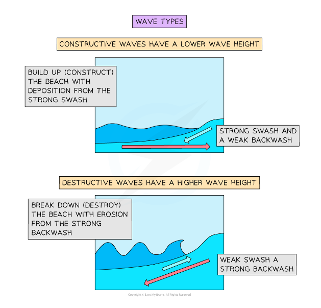
Main Processes at the Coast
Erosion: this is the process by which waves and currents remove sediment from the shore, cliffs, or dunes.
It can be caused by a range of factors, including storms, tides, and sea-level rise.
Transportation: Material is moved along the coast by water and wind.
The main form of transportation is longshore drift
Deposition: is where sediment is deposited along the coast.
This can occur when waves and currents lose energy, or when sediment is carried by rivers and deposited at the coast.
Weathering: Weathering is the process by which rocks and other materials are broken down by physical and chemical processes.
Mass movement: The downhill movement of material under the influence of gravity
Processes of Coastal Erosion
Hydraulic action: This is the process by which waves exert pressure on rocks and cliffs, leading to erosion.
The force of the water can break off pieces of rock and cause the cliff face to become unstable.
Abrasion: the process by which sediment is removed from the coast by the action of waves carrying sediment and other debris, which can cause erosion of the shoreline or cliffs.
Corrosion: is also known as solution, is the process by which waves and currents dissolve soluble rocks, such as limestone or chalk, and carry the dissolved material away, leading to erosion.
Attrition: This is the process by which sediment on the coast is worn down and broken up into smaller pieces by the action of waves and currents, leading to erosion and loss of sediment.
Coastal Landforms (Result of Erosion)
Headlands and Bays:
Formation: Headlands and bays are formed along discordant coastlines where alternating bands of hard and soft rocks run perpendicular to oncoming waves.
The soft rock, such as clay, erodes more quickly, forming a bay, while the harder rock, such as limestone, remains as a headland protruding into the sea.
Features: Headlands are rocky promontories jutting out into the sea, while bays are sheltered coastal indentations with sandy beaches.
Headlands often experience erosion on their exposed sides, leading to the formation of sea cliffs.
Cliffs and Wave-Cut Platforms:
Formation: Cliffs are steep rock faces formed by the erosion of coastal rock by waves and other processes.
As the cliffs retreat due to erosion, they leave behind a flat, wave-cut platform at their base.
Features: Cliffs can be vulnerable to erosion and collapse, especially in areas with high rates of erosion.
The wave-cut platform is a flat surface created by the action of waves undercutting and eroding the base of the cliff.
Caves, Arches, and Stacks:
Formation: Caves, arches, and stacks are formed through the erosion of coastal cliffs by waves.
Initially, wave action erodes softer rock, such as sandstone or shale, creating sea caves.
As erosion continues, caves may extend through the cliff, forming arches. Eventually, the arch collapses, leaving behind a stack, which is a tall pillar of rock isolated from the mainland.
Features: Stacks are often tall and slender, with rugged, vertical sides.
They can be found along coastlines with cliffs composed of contrasting rock types, where erosion rates vary between the softer and harder rocks.
Longshore Drift
Longshore drift is a coastal process whereby waves and currents move sediment along the shore in a zigzag pattern parallel to the coastline.
Formation: Longshore drift occurs when waves approach the shore at an angle.
As the waves break, they carry water and sediment up the beach face at an angle.
Gravity then pulls the water and sediment straight back down the slope of the beach, perpendicular to the shoreline.
This results in a net movement of sediment in a direction parallel to the shore.
Mechanism: The zigzag movement of sediment is caused by the repetitive action of waves breaking at an angle to the shoreline.
Each breaking wave carries sediment diagonally up the beach face, and gravity pulls it straight back down.
As a result, sediment is transported laterally along the shoreline with each wave.
Factors Influencing Longshore Drift:
Wave Angle: Longshore drift is most pronounced when waves approach the shore at an angle rather than perpendicular to the coastline.
Wave Energy: Higher-energy waves are more effective in transporting sediment along the shore through longshore drift.
Beach Slope: The steepness of the beach slope can influence the efficiency of longshore drift, with gentler slopes facilitating greater sediment transport.
Effects: Longshore drift plays a significant role in shaping coastal landforms and sediment distribution.
It contributes to the formation of features such as spits, tombolos, and bars, as well as the erosion and deposition of sediment along the shoreline.
Longshore drift also influences coastal processes such as beach erosion and accretion, shoreline changes, and the movement of sediment in coastal environments.
Coastal Landforms (Result of Deposition)
Spits:
Formation: Spits are long, narrow stretches of sand or sediment that extend from the mainland out into the sea.
They are typically formed by the process of longshore drift, where sediment is transported along the coast by waves and currents. When the sediment reaches a bend or change in the coastline, it accumulates and forms a spit.
Characteristics: Spits are characterized by their elongated shape and may curve slightly at the end due to changes in wave direction or sediment supply.
They often feature a wider, sandy beach on their seaward side and may develop salt marshes or dunes on their landward side.
Examples: Examples of spits include the Chesil Beach in England and the Sandy Hook Spit in New Jersey, USA.
Tombolos:
Formation: A tombolo is a sandbar or spit that connects an island to the mainland.
It forms when sediment is deposited by waves and currents in a specific location, typically at the end of an island.
Over time, the sediment accumulates and connects the island to the mainland, forming a tombolo.
Characteristics: Tombolos often have a narrow neck where the island connects to the mainland, with wider sandy areas extending seaward.
They may feature beaches, dunes, and vegetation similar to those found on spits.
Examples: Examples of tombolos include the one connecting St. Ninian's Isle to the mainland in Scotland and the one linking Mont Saint-Michel to the coast of Normandy, France.
Bars:
Formation: Bars are submerged or partially submerged sandbars that form offshore, parallel to the shoreline.
They are created by the movement of sediment by waves and currents, which causes the sediment to accumulate in a particular location offshore.
Characteristics: Bars may be visible at low tide or remain submerged depending on their depth and location.
They can influence wave patterns and currents along the coastline and may create shallow areas known as shoals.
Examples: Bars are common features in coastal areas around the world, including along barrier islands, lagoons, and estuaries.
Coastal Processes
Wave Types & Characteristics
The coast can be defined as:
The meeting point between land and sea
Coastal processes are divided into two parts:
Marine processes: Offshore (water-based)
Terrestrial processes: Onshore (land-based)
These processes are further divided into:
Wave action
Erosion
Transportation
Weathering
Mass movement
These processes produce the distinctive landforms found around our coastlines
Wave action
Waves are marine processes that erode, transport and deposit material
Waves are formed as winds blow over the surface of the sea
The height and strength of a wave are dependent on 3 factors:
The fetch
The amount of time the wind blows
The strength of the wind
The greater the strength, time and fetch of the wind, the larger the wave
As a wave enters the shallow water of the coast, friction from the seabed causes the wave to lean forward and eventually crest and break onto the beach
The movement of water up the beach is called the swash, and the return movement is the backwash
There are two types of waves:
Destructive waves erode the beach
Constructive waves are beach builders
Constructive Wave | Destructive Wave | |
|---|---|---|
Swash | Strong | Weak |
Backwash | Weak | Strong |
Wavelength | Long with low height | Short with high height |
Frequency | Low (6–8 per minute) | High (10–12 per minute) |
Type of beach | Sandy: depositional | Shingle: erosional |
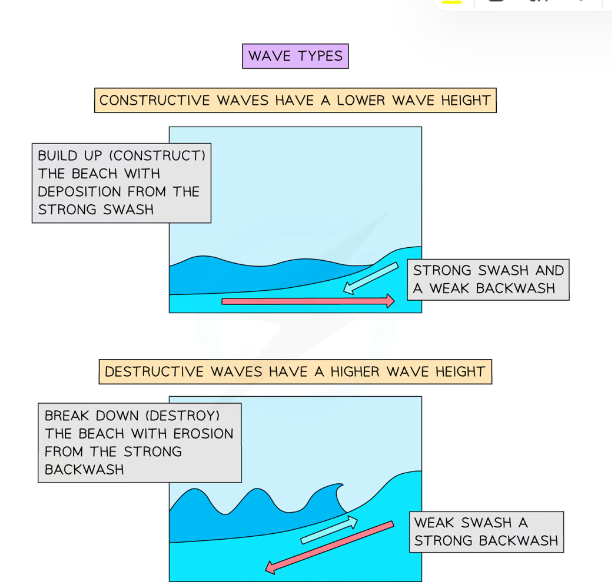
Weathering
Weathering is best defined as:
The break-down of rock in-situ
Weathering does not involve the movement of the material; this is what makes it different from erosion
Sub-aerial weathering describes coastal processes that are not linked to the action of the sea
It includes freeze-thaw weathering (mechanical) and chemical weathering
Weathering weakens cliffs and makes them more vulnerable to erosion
Mechanical weathering physically breaks up rock
Freeze-thaw or frost shattering is where:
Water gets into cracks and joints in the rock
When the water freezes it expands and the cracks open a little wider
When the water thaws, the crack contracts, releasing pressure on the crack
Over time, repeated freezing and thawing, widens the crack until pieces of rock split off the rock face, whilst big boulders are broken into smaller rocks and gravel
Chemical weathering occurs when rocks are broken down by a chemical process:
Rainwater is slightly acidic through absorbing carbon dioxide from the atmosphere
This reacts with minerals in the rock creating new material
Rock-type affects the rate of weathering e.g. limestone chemically weathers faster than granite
The warmer the temperature, the faster the chemical reaction
Biological weathering takes place when rocks are worn away by living organisms:
Trees and other plants can grow within the cracks in a rock formation
As the roots grow bigger, they push open cracks in the rocks making them wider and deeper
Over time the growing tree eventually prizes the rock apart
Burrowing animals, such as rabbits, disturb the ground above the burrow, which puts pressure on any cracks, eventually leading to pieces falling off the rock
Mass Movement
Mass movement is:
The downhill movement of material under the influence of gravity
Throughflow and runoff caused by heavy rain can also make cliffs more unstable and increase the likelihood of mass movement
It includes landslides, slumping and rockfalls
The type of movement is determined by:
Angle of slope (the steeper the slope the faster the movement)
Nature of regolith
Amount and type of vegetation
Water
Type and structure of rock
Human activity
Climate
Soil Creep:
Common in humid climes with the movement of less than 1cm per year
Soil expands when it freezes, gets wet or is heated up in the sun
As the soil expands, it lifts at right angles to the slope
When the soil shrinks, it falls straight back down
Soil creep takes a long time because the soil moves only a millimeter to a few centimeters at a time
Flow:
Occurs on slopes between 5° and 15° with speeds between 1 to 15km per year
Usually happens after the soil has become saturated with a flow of water across the surface
Vegetation is flattened and carried away with the soil
Slide:
A movement of material 'en masse' which remains together until hitting the bottom of a slope
Fall:
Slopes are steep and movement is rapid
Caused by a number of reasons:
Extreme weathering: Freeze-thaw action can loosen rocks that become unstable and collapse
Rainfall: Too much rain will soften the surface leading to the collapse of the slope
Earthquakes can dislodge unstable rocks
Hot weather can dry out soil causing it to shrink and allowing rocks to fall
Slump:
Usually found on weaker rock types (i.e. clay), that become saturated and heavy
This is common at the coast and is also known as rotational slip
It involves a large area of land moving down the slope in one piece
Because of the way it slumps, it leaves behind a curved indented surface
Erosion
Destructive waves are responsible for the majority of erosion that happens along a coast
They carve the coastline in three main ways:
Hydraulic Power/Action
Attrition
Abrasion
There is also a fourth way that waves erode along the coast and that is by corrosion
Transportation
Material in the sea arrives from many sources:
Eroded from cliffs
Transported by longshore drift along the coastline
Brought inland from offshore by constructive waves
Carried to the coastline by a river
Once in the water, the material is moved in different ways:
Traction
Saltation
Suspension
Solution
Deposition
Deposition will happen when transported material is dropped from the sea water
This occurs when the velocity (speed) of the water flow slows down
This means there is not enough force to hold/suspend the material in the water anymore, and it is dropped onto the ground
Beaches are formed of sediment deposited in bays
Salt Marshes and mudflats are formed in sheltered estuaries, usually behind spits
Depositional Landforms
Beaches
Beach formation usually occurs in the summer months when the weather is calmer
Form in sheltered areas such as bays through deposition via constructive wave movement, where the swash is stronger than the backwash
Blown sand can create sand dunes at the backshore of a beach
When a constructive wave carries sediment up the beach, the largest material is deposited along the upper reach of the swash
As the backwash moves back down the beach, it loses water and therefore energy as it travels due to the porosity of the sand
Consequently, the deposition of sediment gets progressively smaller, and the beach is therefore, sorted by wave deposition, with the smallest mud particles settling in the low-energy environment offshore
If a destructive wave forms due to a storm, then large shingle is thrown above the usual high tide level to form a ridge at the top of the beach called a berm
Sand dunes
Sand dunes are a dynamic environment, with quick changes
Sandy beaches usually have sand dunes at their rear, because of strong onshore winds transporting dried, exposed sand
Sand grains are trapped and deposited against any obstacle (rubbish, rocks, driftwood etc) and begin to form embryo dunes
Dune ridges move inland due to onshore winds pushing the seaward side to the leeward side
It is the interaction of winds and vegetation that helps form sand dunes
Formation of a sand dune
Windblown sand is deposited against an obstruction: Pebble or driftwood
As more sand particles are caught, the dunes grow in size, forming rows at right angles to the prevailing wind
Over time, the ridges of the dunes will be colonized and fixed by vegetation in a process called succession
The first plants (pioneer species) have to deal with:
Salinity
Lack of moisture as sand drains quickly (highly permeable)
Wind
Temporary submergence by wind-blown sand
Rising sea levels
Embryo dunes
Wind-blown dried sand is trapped by debris and deposition begins
Pioneer species such as Lyme Grass and Sea Couch Grass begin to colonise
There is little soil content and high pH levels (alkaline)
Embryo dunes are very fragile and reach a maximum height of 1 metre
Fore dunes
The embryo dunes bring some protection against the prevailing wind
This allows other species of plant to grow such as Marram Grass
Marram grass begins to stabilise the dune with its root system
These plants add organic matter to the dunes making the dunes more hospitable for plants that later grow
A microclimate forms in the dune slack
Maximum height is 5 metres
Yellow dunes
These are initially yellow but darken as organic material adds humus to the soil
Marram grass still dominates the vegetation, but more delicate flowering plants and insects are found in the dune slacks
20% of the dune is exposed, down from 80%
Height does not exceed 8 metres
Grey dunes
Grey dunes are more stable, with less than 10% of exposed sand and have a good range of biodiversity
Soil acidity and water content increase as more humus is added
Shrubs and bushes begin to appear
Height is between 8 - 10 metres
Mature dunes
As the name suggests, these are the oldest and most stable of the dunes
They are found several hundred metres or more from the shoreline
The soil can support a variety of flora and fauna such as oak trees and alders (climax vegetation)
This is the final stage in succession which is known as the climax community stage
Coastal Management
Hard Engineering Strategies
Sea walls
Concrete walls that are placed at the foot of a cliff to prevent erosion. They are curved to reflect the energy back into the sea.
Advantages
Effective at protecting the base of the cliff.
Sea walls usually have promenades so people can walk along them.
Disadvantages
Waves are still powerful and can break down and erode the sea wall.
Expensive - approximately £2,000 per metre.
Rock armour
Large boulders placed at the foot of a cliff. They break the waves and absorb their energy.
Advantages
Cheaper than a sea wall and easy to maintain.
Can be used for fishing.
Disadvantages
They look different to the local geology, as the rock has been imported from other areas.
The rocks are expensive to transport.
Gabions
Rocks are held in mesh cages and placed in areas affected by erosion.
Advantages
Cheap - approximately £100 per metre.
Absorbs wave energy.
Disadvantages
Not very strong.
Looks unnatural.
Groynes
are wooden or rock structures built out at right angles into the sea.
Advantages
Builds a beach - which encourages tourism.
They trap sediment being carried by longshore drift.
Disadvantages
By trapping sediment it starves beaches further down the coastline, increasing rates of erosion elsewhere.
They look unattractive.
Soft Engineering Strategies
Beach nourishment
Sand is pumped onto an existing beach to build it up.
Advantages
Blends in with the existing beach.
Larger beaches appeal to tourists.
Disadvantages
Needs to be constantly replaced.
The sand has to be brought in from elsewhere.
Reprofiling
The sediment is redistributed from the lower part of the beach to the upper part of the beach.
Advantages
Cheap and simple.
Reduces the energy of the waves.
Disadvantages
Only works when wave energy is low.
Needs to be repeated continuously.
Dune nourishment
Marram grass planted on sand dunes stabilises the dunes and helps to trap sand to build them up.
Advantages
Relatively cheap.
Maintains a natural-looking coastline.
Disadvantages
Can be damaged by storm waves.
Areas have to be zoned off from the public, which is unpopular.
Managed Retreat
Managed retreat is the controlled flooding of low-lying coastal areas. If an area is at high risk of erosion, managed retreat could be an option. It usually occurs where the land is of low value, for example farm land.
Advantages
This is a cheap option compared to paying for sea defenses.
Creates a salt marsh which can provide habitats for wildlife and a natural defense against erosion and flooding.
Salt marshes are diverse ecosystems supporting many species.
Disadvantages
Land is lost as it is reclaimed by the sea.
Landowners need to be compensated - this can cost between £5,000 - £10,000 per hectare.
River landscapes in the UK
Drainage Basins
A drainage basin (or catchment area) is the area of land where precipitation collects and drains off into a common outlet, such as into a river, bay, or other body of water.
It includes all the surface water from rain, snowmelt, and nearby streams that flow downhill into the common outlet, as well as the groundwater beneath the earth's surface.
River Stages
Upper Course:
Characteristics: Steep gradient, V-shaped valleys, narrow channels, and often interlocking spurs.
Processes: Dominated by vertical erosion (downcutting).
Landforms: Waterfalls, rapids, and gorges.
Middle Course:
Characteristics: Moderate gradient, wider and shallower valleys, and meandering channels.
Processes: Balance of erosion (lateral) and deposition.
Landforms: Meanders, oxbow lakes, and river cliffs.
Lower Course:
Characteristics: Gentle gradient, wide floodplains, and very wide channels.
Processes: Dominated by deposition.
Landforms: Floodplains, levees, and deltas.
Velocity of Water
The velocity of water in a river is the speed at which water flows through the channel.
It is influenced by the gradient of the riverbed, the channel shape, and the volume of water.
Generally, velocity increases from the upper course to the lower course due to decreased friction and increased discharge.
Fluvial Processes and Landforms
Erosional Processes
Abrasion: The process by which the river’s load (sediment, rocks) grinds against the river bed and banks, wearing them away.
Attrition: The process by which particles carried by the river collide and break into smaller, smoother pieces.
Hydraulic Action: The force of the water itself breaks rock particles away from the river bed and banks.
Corrosion (Solution): The process by which acidic water dissolves soluble minerals from the bed and banks, particularly in limestone and chalk areas.
Transportation Processes
Solution: Minerals are dissolved in the water and carried along in solution.
Suspension: Fine light material is carried along in the water.
Saltation: Small pebbles and stones are bounced along the river bed.
Traction: Larger boulders and rocks are rolled along the river bed (although this term is not mentioned in the prompt, it completes the list of transportation processes).
Deposition
Deposition occurs when the river loses energy and drops the sediment it is carrying.
This can happen in the lower course of the river where the water is slower, in areas of shallower water, or where the river enters a larger body of water like a lake or the sea.
River Landforms
Upper Course
Interlocking Spurs: Ridges of hard rock around which a river winds.
Found in the upper course, these spurs interlock as the river cuts its path through the landscape.
Waterfalls: Occur where a river flows over a vertical drop or cliff.
Formed by differential erosion, where hard rock overlays softer rock, leading to the softer rock eroding away more quickly.
Gorges: Narrow, steep-sided valleys formed as waterfalls retreat upstream over time, cutting into the landscape.
Middle Course
Meanders: Large bends in the river formed by lateral (sideways) erosion and deposition.
The outside of the bend experiences more erosion (forming river cliffs), while the inside sees more deposition (forming point bars).
Ox-Bow Lake: Crescent-shaped lakes formed when a meander is cut off from the main river, usually during a flood when the river takes a shorter course.
Lower Course
Floodplains: Flat areas of land adjacent to the river that flood during periods of high discharge.
They are built up by layers of alluvium (silt and clay) deposited during floods.
Levees: Raised banks along the river formed by the deposition of sediment during flood events. These can be natural or artificial.
Estuaries: Wide river mouths where the river meets the sea.
Characterized by tidal influence and a mix of freshwater and saltwater, with extensive mudflats and salt marshes.
Flooding
Human Factors Increasing Flood Risk
Urbanisation: Increases surface runoff due to impermeable surfaces like roads and pavements, reducing natural infiltration.
Deforestation: Reduces the number of trees that can intercept rainwater, increasing surface runoff.
Capacity of the River: Reduced by sedimentation or artificial modifications, which can limit the river's ability to contain high flows.
Physical Factors Increasing Flood Risk
Rate and Volume of Rain: Intense or prolonged rainfall can overwhelm river systems, leading to floods.
Geology: Impermeable rocks and soils increase surface runoff, while permeable ones allow more infiltration, reducing flood risk.
Topography: Steep slopes encourage rapid runoff into rivers, increasing flood potential.
Storm Hydrographs
Features of Storm Hydrographs
Peak Precipitation: The highest point of rainfall during a storm event.
Rising Limb: The part of the graph that shows the increasing river discharge as rainfall enters the river.
Peak Flow (Discharge): The maximum flow in the river during the storm event.
Lag Time: The delay between peak precipitation and peak discharge, indicating how quickly the rainfall reaches the river.
Falling Limb: The part of the graph that shows the decreasing river discharge as the river returns to normal levels.
Base Flow: The normal day-to-day discharge of the river, fed by groundwater.
Types of Flooding
Flash Flooding: Sudden and severe floods typically caused by intense rainfall over a short period. These occur with little warning and can cause significant damage.
Subdued Flooding: Develops more slowly, typically from prolonged rainfall, and can last longer.
It allows more time for warning and evacuation but can cover larger areas and cause extensive damage.
Management of Drainage Basins
Drainage Basins
A drainage basin (or catchment area) is the geographical area drained by a river and its tributaries.
Effective management of drainage basins is crucial to mitigate flooding, ensure water quality, and maintain ecological balance.
Sustainable Management
Sustainable management of drainage basins aims to balance the economic, cultural, social, and environmental values while minimizing adverse impacts.
Strategies focus on long-term viability, community involvement, and preserving natural processes.
Choosing a Management Strategy
Economic Value of the Land: Areas with high economic importance (e.g., urban centers, agricultural land) may prioritize flood protection and water management to protect investments and livelihoods.
Cultural or Social Value: Land with cultural or historical significance might be managed to preserve heritage sites and maintain community identity.
Environmental Value: Management strategies may aim to protect biodiversity, maintain natural habitats, and ensure the health of ecosystems within the basin.
Soft Engineering Strategies
Floodplain Zoning: Regulates land use within floodplains to prevent development in high-risk areas, reducing flood damage.
It preserves the natural floodplain and its ability to absorb floodwaters.
Wetlands: Creation or restoration of wetlands to act as natural sponges, absorbing excess water during heavy rains and slowly releasing it, reducing flood peaks and enhancing water quality.
Hard Engineering Strategies
Dams: Built across rivers to control water flow, store water, and generate hydroelectric power.
They can significantly reduce downstream flooding but can be expensive and have environmental impacts.
Embankments: Raised banks along river edges to contain water within the channel during high flow.
They provide immediate flood protection but can lead to increased flooding downstream.
Dredging: Removing sediment from the riverbed to increase channel capacity and improve flow.
This reduces flood risk but can disturb aquatic habitats.
Channel Straightening: Modifying river channels to increase the velocity of water flow, reducing the likelihood of flooding in certain areas.
However, it can increase erosion and downstream flooding.
Flood Relief Channels: Constructing additional channels to divert excess water away from high-risk areas, reducing pressure on the main river channel.
Flood Management
Sandbags: Temporary barriers constructed using sand-filled bags to protect properties and infrastructure during flooding events.
They are cost-effective and easy to deploy.
Temporary Flood Barriers: Portable barriers that can be quickly erected in response to flood warnings.
They offer flexible protection and can be moved as needed.
Road Closures: Shutting down roads in flood-prone areas to prevent accidents and allow emergency services to operate efficiently.
It helps in managing traffic and ensuring public safety during floods.
Glacial landscapes in the UK
Ice was a powerful force in shaping the physical landscape of the UK.
The last ice age, known as the Devensian glaciation, had a significant impact on the country's topography, creating various landforms through processes of erosion, transportation, and deposition.
Maximum Extent of Ice Cover
During the last ice age, the maximum extent of ice cover in the UK reached as far south as the Bristol Channel and covered much of Scotland, Ireland, Wales, and northern England.
This extensive ice sheet profoundly influenced the landscape, leaving behind distinct glacial features.
Glacial Processes
Freeze-Thaw Weathering
Process: Water enters cracks in rocks and freezes. As it freezes, it expands by about 9%, exerting pressure on the rock.
Repeated cycles of freezing and thawing cause the rock to break apart.
Impact: Contributes to the breakdown of rock in glacial environments, providing material for erosion and transportation.
Erosion
Abrasion: Occurs when rocks and debris embedded in the glacier base scrape and grind against the bedrock as the glacier moves.
This process smooths and polishes the underlying rock.
Plucking: Happens when the glacier freezes onto bedrock, and as it moves, it pulls pieces of rock away.
This process creates jagged landscapes and contributes to the glacier's erosive power.
Movement and Transportation
Rotational Slip: Occurs in corries (cirques), where the glacier moves in a circular motion. This movement deepens the corrie basin and creates a steep back wall.
Bulldozing: The glacier pushes debris in front of it as it advances. This process transports large amounts of material and can form terminal moraines at the glacier's snout.
Deposition
Why Glaciers Deposit Sediment: When glaciers melt, they lose the energy needed to carry debris, leading to the deposition of sediment. The type of sediment deposited can vary based on the glacier's environment and the material it carries.
Till: Unsorted and unstratified material deposited directly by the ice. It includes a mix of clay, sand, gravel, and boulders.
Outwash: Sorted and stratified material deposited by meltwater streams flowing from the glacier. It typically consists of sands and gravels and forms features like outwash plains and eskers.
Distinctive Glacial Landforms
Landforms Resulting from Erosion
Corries (Cirques)
Characteristics: Armchair-shaped hollows with steep back walls and a lip at the front.
Formation: Formed by rotational slip and freeze-thaw weathering.
Snow accumulates in a hollow and compresses into ice. The glacier erodes the hollow through plucking and abrasion, creating a deep basin.
The lip is often formed from deposited moraine.
Arêtes
Characteristics: Sharp, knife-edge ridges.
Formation: Formed when two adjacent corries erode back towards each other. The steepening of the sides and the narrowing of the ridge between them create an arête.
Pyramidal Peaks
Characteristics: Sharp, pointed mountain peaks.
Formation: Formed when three or more corries erode back towards a central point, creating a steep, pyramidal shape.
Truncated Spurs
Characteristics: Blunt-edged ridges that descend into the valley.
Formation: As glaciers move down pre-existing river valleys, they cut through the spurs of the valley sides, truncating them and creating steep cliff-like features.
Glacial Troughs (U-shaped Valleys)
Characteristics: Wide, flat-floored valleys with steep, straight sides.
Formation: Formed as glaciers move through river valleys, they erode the sides and floor through abrasion and plucking, transforming a V-shaped river valley into a U-shaped valley.
Ribbon Lakes
Characteristics: Long, narrow lakes occupying a glacial trough.
Formation: Formed in U-shaped valleys where softer rock has been eroded more deeply by the glacier, or where a terminal moraine has dammed the valley.
Hanging Valleys
Characteristics: Smaller valleys that join the main glacial trough at a higher level, often with waterfalls.
Formation: Formed when smaller tributary glaciers join a larger glacier. The larger glacier erodes the valley floor more deeply than the tributary glaciers, leaving the tributary valleys hanging above the main valley.
Landforms Resulting from Transportation and Deposition
Erratics
Characteristics: Large boulders that are different in composition from the local geology.
Formation: Transported and deposited by glaciers, often over long distances from their source area.
Drumlins
Characteristics: Elongated hills of glacial till with a steep stoss side and a gentle lee side.
Formation: Formed under moving ice. The exact mechanism is debated, but they are generally thought to be shaped by ice moving over and reshaping previously deposited glacial till.
Types of Moraine
Terminal Moraine: Ridge of debris deposited at the furthest point reached by a glacier.
Lateral Moraine: Debris deposited along the sides of a glacier.
Medial Moraine: Ridge of debris found in the center of a glacier, formed when two glaciers meet and their lateral moraines combine.
Ground Moraine: A blanket of till deposited under a glacier.
Example of an Upland Area in the UK Affected by Glaciation
The Lake District
Location: Cumbria, Northwest England.
Major Landforms of Erosion:
Corries: e.g., Red Tarn near Helvellyn.
Arêtes: e.g., Striding Edge.
Pyramidal Peaks: e.g., The summit of Helvellyn.
Glacial Troughs: e.g., Borrowdale and Langdale valleys.
Ribbon Lakes: e.g., Ullswater and Windermere.
Hanging Valleys: e.g., Grisedale, leading into Ullswater.
Major Landforms of Deposition:
Erratics: Large boulders scattered around the area, often differing from the local rock.
Drumlins: Found in the southern part of the Lake District, particularly around the area of Kendal.
Moraines: Terminal moraines can be seen at the ends of some valleys, such as at the southern end of Lake Windermere.
Economic Activities in Glaciated Upland Areas
Overview of Economic Activities
Tourism
Glaciated upland areas offer spectacular landscapes, attracting tourists for hiking, climbing, skiing, and sightseeing.
Examples: Lake District, Scottish Highlands, Snowdonia.
Farming
Primarily sheep and cattle grazing due to the rugged terrain and poor soil fertility.
Farming maintains traditional landscapes and supports rural communities but is often low-income.
Forestry
Planting and harvesting of trees for timber and paper production.
Provides economic benefits and supports biodiversity, but can alter natural landscapes.
Quarrying
Extraction of stone, slate, and other materials.
Important for local economies but can cause significant landscape disruption and environmental issues.
Conflicts Between Different Land Uses
Tourism vs. Farming: Tourists can damage farmland, disturb livestock, and create litter, conflicting with farming operations.
Tourism vs. Conservation: High visitor numbers can lead to footpath erosion, wildlife disturbance, and littering, conflicting with conservation efforts.
Forestry vs. Conservation: Large-scale forestry operations can disrupt habitats and biodiversity, conflicting with conservation goals.
Quarrying vs. Tourism: Quarrying operations can be visually intrusive, noisy, and environmentally damaging, detracting from the natural beauty that attracts tourists.
Example: The Lake District
Attractions for Tourists
Natural Beauty: Scenic landscapes, lakes, mountains (e.g., Scafell Pike), and valleys.
Outdoor Activities: Hiking, climbing, boating, and cycling.
Cultural Sites: Historic villages (e.g., Grasmere), homes of famous poets like William Wordsworth, and Beatrix Potter's house.
Social, Economic, and Environmental Impacts of Tourism
Social Impacts
Positive: Creates jobs in hospitality, retail, and guiding services. Preserves local traditions and cultures through visitor interest.
Negative: Can lead to overcrowding, traffic congestion, and pressure on local infrastructure.
Seasonal jobs may lead to economic instability for residents.
Economic Impacts
Positive: Significant contributor to the local economy through spending on accommodation, food, and activities. Supports local businesses.
Negative: Can cause inflation in property prices, making it difficult for locals to afford housing.
Dependency on tourism can make the economy vulnerable to downturns.
Environmental Impacts
Positive: Funding for conservation efforts through tourism revenue.
Negative: Footpath erosion, littering, and pollution. Increased pressure on natural resources and wildlife disturbance.
Strategies to Manage the Impact of Tourism
Footpath Maintenance: Repairing and maintaining paths to reduce erosion and protect landscapes. For example, the Fix the Fells project in the Lake District.
Zoning: Designating specific areas for different activities to minimize conflicts and protect sensitive areas.
Sustainable Transport: Promoting public transport, cycling, and walking to reduce traffic congestion and pollution. For example, park-and-ride schemes and improved bus services.
Visitor Education: Providing information on responsible behavior, conservation efforts, and the impacts of littering and wildlife disturbance.
Capacity Management: Limiting the number of visitors in certain areas during peak times to prevent overcrowding and environmental damage.
Supporting Local Businesses: Encouraging tourists to use local services and products to benefit the local economy and reduce the carbon footprint associated with travel.