Water systems & Water Sensitive Design
Working with integrated systems: Water-Sensitive Urban Design and Nature-based solutions for water
How to work with water?
Relationship between Humans and Water?
humans over time, power dynamic where infrastructure and enginuity capacity to control water and direct throguh building capacity how to store, transport, move water.
before had to look at settelements in relation to water sources
negotiate availability of water to live in tenuous environments from freshwater aspect
Water ties land and people together
ridge to reef (Samoa) are a moananui living system, the whole of catchment understanding grounded in an understanding of water
ki uta ki tai is maori interpretation of the system
How to integrate into projects?
infrastructure repurposed
rain gardens to prevent water from hitting (runoff into) buildings but harbours and other networks of water
wetlands, can be made wetlands either as completely resotrative or available for open space while doing its main job of filtering.
Water Systems
Main Points
Fua’iala is fundamentally a water system, water system catching is a core part of regeneration over many generation
Water is a cycle and whole system, constantly transitioning
We can’t isolate it eg fresh water
Ground water deep time scales
Water run off short time scales
Flood damage based erosion short scale, irrigation can be long time scales
Time spent with water, young landscapes have smaller waterbodies, older landscapes
water in constant relationship with existing landscape
Beaches don’t exist without rivers causing coastal erosion and depositing material
Fertile crescent shows this new understanding of water, grains are good for sustaining us and does not perish.
In Nineveh city, Sennacherib design had water infrastructure from there hanging gardens of babylon that drew water across hundreds of km fom persian mountain rnage through aquaduct systems and below ground structured tunnels (Qanat) arrives in the city to create luscious vegetative environments
Qanat multiple wells to be built and tunnel and grade to transport water in a straight line while using where water is naturally below ground to feed into it (water tables)
Archimedes is known for it but these people did it couple hundred years before
romans were widely known for aquaducts
Water ways vertical to create vertical gardens
screw systems were used to raise water vertically
The hanging gardens of Babylon was ruled by Nebuchadnezzar II is known for these, because he was significant leader. Babylon included city of Nineveh and all the mesopotamian basin.
Egyptian residence the enclosed building was small compared to the garden area which had a pool of water to provide water for the family, it is an air conditioning system
each house oriented so water source drew prevailing breezes across the water cooling the air and into the homes
most significant constructed face oriented towards the sun for passive heating and water source was on the other side to draw air across and through the most open face of the house and cool it down
clay absorbed moisture which helped with cooling
Roman residences influencd by Greek
use of atrium and peristyle gardens and roof structure to collect water into the home to be used
peristyle gardens, away from street of a house (back) wth water in the garden
Rome structure
aquaduct from middle east to transition water across long distances to crete incredible public fountains
public work done by leaders of Rome to win favour over the people of Rome, creating infrastructure that benefits them
existing stormwater systems use a lot of was built in Roman context
streets during rain would become running rivers so gaps of rasied stone across the road to walk over the roads when it got flooded but still allowed chariots to still move
China rice terraces
terracing system that move water to grow rice
Modes of water interaction with ground surface
ocean, rain, flooding
Moananui Living systems, living in relationship with a water system

Extended Talk
thinking about groundwater, these are deep time scales, but when you're thinking about things like surface runoff, those are really acute short time scales. When you're thinking about erosion over time, those are long time scales. But when you were thinking about flood damage based erosion, so that fast, high energy erosion, that can happen on really short scales. So, time is a really key consideration as well.
So, we can often tell a lot about a landscape, and the form of it based on its relationship to water or the amount of time that it has spent with water. So, young landscapes typically have much smaller water bodies. They, for example, like if we think about the Southern Alps, that's old material, but as a landscape, it's constantly evolving because those maunga in the Southern Alps of aotearoa are continuing to grow, The tectonic plates are pushing them up, and they're continuing to get bigger. And so the water is in a constant relationship with that shifting landscape. And therefore, its impact is tempered by that shifting environment. And then, as we move down through the landscape, you think about, this South Island of New Zealand landscape So you have this kind of mountainous hinterland, which is, you know, when it gets into those alpine zones, it's really kind of raw, rocky environment. And then as you come forward, you get kind of the kind of rolling hill environments. And that's kind of, more eroded landscapes. They've had more interactions with water. They're obviously at various points, being parts of the pathway of the various rivers. So if you think about the incredible range of large scale rivers in the South island, for example. Many of those hills probably are even depositions. So material that's been deposited by those waterways over time. And then you get down onto the Canterbury Plains. And that's essentially where all of these rivers spread out and drop all of their material. And they're big, and they're wide, and they're flat, and the river has made pretty much all of those flood plain environments. And it's made up of the material that these rivers have accumulated over time from these mountainous landscapes and redeposited them. And it feeds all of our coastal systems. So we don't have beaches unless we have rivers doing the erosive work. And depositing that material. We don't have a responsiveness or a climate adaptive flexibility to things like coastal erosion and sea level rise. If our rivers aren't able to do this, or if we take that material out too soon. So when we add humans into the situation, um, it becomes more complicated. Water has been doing its things since the very foundation of our planet and has been relating to its physical context.
much more settled communities due to new understanding of capacity of water, which became the foundation of civilisation and cities. The best evidence of this happening in the fertile crescent. An environment where wild grains were privileged and were able to be domesticated as a result of this new relationship with water, this new understanding of our capacity to control and direct water availability. And the wonderful thing about grains is they're an excellent food base that allow us to sustain ourselves for an extended period of time. Yeah. It's also quite easy to grow up in large quantities and it doesn't perish. So it's a great foundational food source.
And some of the water infrastructure that comes from this part of the world is pretty unbelievable. There is, archeological evidence of the hanging gardens of Babylon. So a huge water infrastructure project. In an arid (very hot) essentially, part of the world. that drew water across 100s of kilometres from the kind of Persian mountain range, into the city, through an aqueduct, and Connaught system. So water travelling above ground in constructed aqueduct systems, and below ground in constructed tunnels, which is the Qanat system. And that below ground's important because if you're in an arid climate, the water doesn't evaporate as readily. And then it arrives in this city at such a scale, that you can create these lush, vegetated environments, right?
This guy is also responsible for, um, the 1st example or the 1st documented example of what we now understand is Archimedes' Water Screw. Which is a really crazy mechanical system. So this is one of the 1st examples of that and was able to essentially lift water up over significant distances vertically to then create these incredible vertical garden structures. So, Archimedes has renouned for it. But probably got it from these guys who were here at least a 1000 years sooner. So this is the artist's representation, and this is a fragment of a panel at the time that depicts depicted in a stylised version, the actual garden. So you can see here these waterways, you can see these constructed aqueducts You can see the vegetation on significant layers, and then this is the based on the archeological foundations that have been found in what is now modern day Iraq. So, this is the evidence, which is pretty cool. So, Sennechrib was a significant leader, king/Sultan, is from the Assyrian empire at the time, and he talks about his garden. He talks about his control, and he talks about his power of water, and he talks about his ways of using water, the water and the gardens that it's able to create as a way of showing not just his wealth, but his power, and then also his benevolence, like his ability to then gift that to the people of the world. So, over great distance, I had a water course directed to the environs of Nineveh, and Nineveh is where the city is, joining together the waters, over steep sided valleys, I span an aqueduct of white limestone blocks, and I made those waters flow over it. So this is before the Romans were doing aqueducts. This was before the Greeks or before Alexander the Great had travelled into this part of the world. He created clay mounds as if by divine intelligence. For cylinders and screws in order to draw water up all day long. So that's the description of what is now understood to be the basic Archimedes screw structure. So he essentially created a well system with a screw inside it that drew the water vertically. And ropes and bronze wires and bronze chains are like fancy metals. Instead of shadoof, which is a bucket system that is suspended on a stick that was used, like it uses a pivot point to be able to lift the water up from deep into well systems, for example. So rather than using that system, this screw system allowed him to consistently lift water up across these large vertical distances. He raised the height of the surroundings of the palace to be a wonder for all people's high garden, imitating the ominous mountains. Now, the reason why that's important is because his wife was imported to Nineveh, brought to Nineveh. and he built this garden to give his wife somewhere that reminded her of home. And if you guys remember the story of the hanging Gardens of Babylon, it talks about a love story, it talks about a king who built the hanging gads of Babylon for his wife. Interestingly, the king that is attributed, who sat in Babylon at the time of which those writings happened by the Roman scholars, he wasn't so keen on the wife. So, it's another reinforcement of evidence that suggests that this is probably where those stories started.
Anyway, these incredible gardens included a range of plants that were not native to this area. So, this transportation of water, this control of water, across extensive distances, enabled exotic plant species to be grown on mass. To create gardens and spaces where they wouldn't otherwise have existed. And result of that is that there's now food resources available in this city that would not otherwise have been available locally in the same way. But there is also a microclimate that gets created as a result of these plants. So you increase the humidity in the air. You create the shading and the capacity to cool as a result of the water. And so, that's kind of a water relationship that becomes a significant part of cities following this point. From the Western world.
Here are some archeological drawings. of actual components, foundations of these aqueducts, versus artists renditions of the scale of these across the landscape. This is like 1000 BC. Pretty incredible Acts of engineering. That would have had quite significant, if you think about our modern catchments, would have had a really significant impact on the surrounding landscape. So this river, that this waterway crosses, is now being bridged by four arches. But What happens if that river wants to flood? What might that mean for the surrounding valley? So the human relationship with water is already complicated. And this map gives a sense of how far these waterways travelled. So here is Nineveh. And these are the canals here, and these dark lines, and then these dotted lines going up into the mountains in the distance. Hundreds of kilometres, thousands across most of Iraq and countries to the north, this is another system that comes from the same part of the world. This is the Qanat system, so they function based on a really steady incline or decline towards the water's destination, underground, again, for sometimes 100s of kilometres. So this requires multiple wells to be built and then it requires tunnelling and engineering below ground, at a perfect grade to move that water across the landscape, in a straight line, because that's the most efficient way to move the water. And taking the advantage of a relationship to the water table, so where the water naturally is below ground, to feed this. But also by being below ground, so you see it kind of flowing out into the fields. So it's doing irrigation. So you not only have to know where the water table is in the distance, you need to know how far down it is. You have to be able to map across the surface where your wells are going to go down, and then you have to connect those underground, all of the time, you're using human power, A 1000 BC, relatively rudimentary, probably metal based, but still hand tools. But our cities are built on this. And so this is the famous hanging gardens of Babylon. As you can see, it happened almost 600 years later. These particular hanging gardens of Babylon. And that is predominantly because he was the significant leader in the space. He may well have had lush gardens like this. but the people who wrote about it were Roman and they weren't alive in either his lifetime or in Sennucherib . So they're not personal accounts, they're long story narrative accounts across time. And this is what is considered to be a popular artist's representation based on the building styles of that time in this city, Babylon. Babylon, at this point, was actually an empire that included the city of Nineveh. It stretched across the whole Mesopotamian person, particularly the neo Babylonian Empire. Also got all the way to Egypt.
So, it's not until 100 BC. Well, actually 250 BC. that we start to get the officially recognised accounts that made this one of the 8 wonders of the world. So these guys could not have been alive at the time at which these were believed to have existed. But it's still interesting because it talks about how incredible feats of infrastructure and incredible capacity to move water echos through time.
So this is a really lovely example. The Egyptians are incredible because they love to keep records of everything in their tombs. to carry through into the afterlife. And so we have this incredible resource, rich resource that allows us to understand not just what, about, the way Egyptians lived, but also the how and the why. So this is a really lovely example of a wealthy Egyptian home. You can see that the home actually is a relatively small part of the precinct. the enclosed building, and actually, there's a large enclosed garden as part of it, and most importantly, in an arid climate in the tropical kind of band, the world A large pool of water, and that pool of water in the garden had a dual purpose. Purpose one was that it provided the drinking water, the cooking water, the washing water, for the family that lived in the home. And purpose too, which is perhaps the most important purpose, it is an air conditioning system. So every single one of these houses was orientated. so that the water source drew the prevailing breezes, across the water, cooling the air, and then into the homes. So, the houses were orientated so that their most built face, so there most significant constructive face, was oriented towards the sun. Because it has the benefit of both passive heating, which is useful, but also it has a shading responsibility. And then the water source was on the other side, so in this case, on the northern side and it would then draw the air across, cool the air that would then go into the most open face of the house and cool the inside of the house down. That also had really cool systems where their buildings were made of clay, which absorbed the moisture, and that also did cooling. Another example from Roman residences, which, of course, were influenced heavily by Greek, and by Egyptian residences, is the use of the atrium and the peristyle garden and the roof structures to bring water inside the home, it actually probably had triple purpose. there was a collecting water value in atrium. So, the roofs were angled to bring the water in so that they could collect it for the house use. It also provided a cooling role. So it, again, was about circulating and cooling, and the property, and then there was the added water feature value. And then, and the peristyle gardens, which are the gardens towards the back of the house, so away from the street frontage, typically. You would again have water as part of that garden, and there was a mix of different ways that that happened. If you're really rich, you might have fountains, so that was moving water. And perhaps the less wealthy would have a pool again, that would be collecting water, and that water would be used to support the growing predominantly of vegetables, but also some ornamentals as part of that house. So the Romans learned a lot about water, and how to work with it, and how to use it to their best advantage. From the many different places that their empire reached out to.
So they bought the aqueduct systems back from the Middle East. They were able to, because of that, water was able to be transitioned across long distances, they will be able to use it to create these incredible public fountains. Because as, at that point, a democracy, you needed the people to vote you into power. Yeah, to reinforce your power. And so there were lots of actions of public work, that were undertaken by the leaders of Rome, to gun of a favour, of the Roman people. So things like public bathhouses. With complex heating systems. so that they could wash regularly, public bathrooms, toilets, and sanitation systems that were city level infrastructure. Most of which, interestingly enough, is still used in many of these big Roman cities. So, sewerage systems, stormwater systems still use the same underground infrastructure that was often built in the Roman context. They also understood how water worked in terms of their road systems. So they knew that if they paved more of their environment, that when it did rain, and remembering that Italy and many of these city environments were pretty hot, and so rain was something that wasn't regular, it wasn't a damp environment, it was a predominantly dry environment. So when it did rain, they knew that it was going to move across the ground pretty quickly because the ground was pretty hard. Yeah, it wasn't gonna absorb, really and they designed their streets to accommodate that. So their streets during rainy days, or rainy weeks, depending on how they came across, would become running rivers. And you can see these blocks if they're crossing the street, and they have a gap in them to allow the water through, but also to allow the carts to continue to navigate down these streets. And here's an example of some of the underground sewage systems. They're incredible examples of terraced systems that enabled large scale rice in this instance, large scale rice agriculture and mountainous environments that wouldn't otherwise have supported the growing of a crop. So it's simple terracing system, captured the water that was naturally flowing through this environment, creating ideal habitat for rice. At scale so these incredible landscapes, and you can see how big they are about understanding how water works and harnessing it to support, to support large scale, large scale production. So when we think about what do we need to think about the multiple different modes in which it moves and interacts with the ground surface? So We have kind of water that moves in large bodies. It might not be fierce looking, but it has huge power.
So I'm gonna remind you of this quote from 1st year, if you guys remember, that water or wai means water, but it also means memory and who? I think that's really important in this context because Water, and many of the interactions, the negative interactions that we might have with it in urban environments in particular, is because we've forgotten how that water works. We're not thinking about how water moves within the environments that we're living in. We're thinking in short term human life scales rather than in long-term deep knowledge understandings of how water works. But also in the who of the water, we can understand more of that because we can ground that water and the indigenous knowledge is that help us to understand the depth of it, but also in where that water comes from, what it touches, what it interacts with before it gets to us. And then also what it will interact with after it's past, past us. So it's a useful way of framing and understanding of water. This is another slide you guys have seen before. This was an exercise in trying to map the mini courses of the Mississippi River. And then realising that actually that was impossible. Because the river was so actively moving. that you couldn't, you can't truly map the watercourse across time. You can only map it for a point in time. And that's one of the biggest challenges that we have as a human urban species is that we like everything to fit into maps and plants. We like to build physical things that are gonna last for a long time. And water doesn't really adhere to that. principle. It'll rub up against it. It'll kind of, you know, entertain the idea for a while. But fundamentally, it's not really listening. And so if we go back to this idea that water ties the land and the people together, it's the thing that keeps us in check. It's the thing that gives us life. It's the thing that helps us to understand how we relate to the wider world. That's a really useful framing of water when you're thinking about whole of catchment systems like you are, Hawana. And going back, again, lots of slides from 1st year, I apologise for the repetition, but sometimes it's good to refresh. This idea of kia uta kitai → mountain to sea, or I'm sure you've heard ridge to reef. These are Moananui living systems. They are Fua’iala they are the whole of catchment understandings. that is grounded in an understanding of water. And this is the Maori iteration of this system. And as we know, from the last 2 years, the maori iteration of the system, is the baby child in the knowledge evolution across the Pacific of this relationship to water at a system scale.
We were the last to be populated by humans. So, this is the last system to evolve from that shared ancestral knowledge that came initially through rarotonga through the Tapari system. But also very closely connected In terms of that navigation relationship. So, catchment thinking is really important. We need to think about everything together. We need to think about it from the atmospheric relationship. So water as gas. water is part of air, water as clouds, or rain waiting to fall. As well as water as a physical liquid source. Both moving across the surface of the land, but also soaking into and feeding the groundwater below the ground surface. And then connecting into the ocean environment that saline environment. And also constantly evaporating and refeeding the air This is the Ahupua such an incredible understanding of how humans can live within a water system, in relationship with a water system. So we think, where am I in relationship to the catchment? Human. Larger scale human connection happens in the lower catchment or the upper lower catchment and the lower mid catchment zone. About the point where if we think about, the South Island again, if we think about Canterbury Plains, this is the hills before you get into the alpine zone. So we're outside of flood risk, and we're outside of salt, significant salt influence, so that we can grow crops. But we're still within reach of these resources, and we're within reach of these wider Nahi resources. The land here is too steep to live on, and here is just right. This is the Goldilocks zone, so to speak. So the sphere of influence is really important. When you're looking at your, um, at your catchment in Savai, think about where am I putting my where am I putting my buildings? Where do they sit within this whole catchment? Think about it from a group perspective. How do they relate to one another? What I'm doing in the upper catchment? What does that mean for the mid catchment? And then what does that mean for the lower catchment? Because your responses will be different. for each of those spaces based on the relationship to that wider water system or they should be.
Main Points
Impervious surface levels rise above the catchment how it affects
capacity for absorption, flow rate (from obstructions)
ground water for drinking, longest time to filter and purify, least likely to get heavy metal solutants found in surface water
Pollution part of water system in the air, disruption in ground water recharge, more draw of water resources due to designing taller buildings that allow populaition to densify within an area.
Shading water controls evaproration rate of water
Buildings and hard surfaces are only bad when they do not consider water
WSD in the Auckland Unitary Plan
land use planning and development
what we do to build on the land
understanding water solutions is across nested scales not just development of site, so wider region, but needs to have both regional and site
protecting and enhancing water resource systems
replicating natural processes

Resource: Water Sensitive Design for StormWater - Auckland Council
When having vegetation around city means when water flood, soak, and flow, then built infrastrcuture less likely to be harmed during environmental threats

what types of landscape is water moving across, what ecosystems do we need to acknowledge and value in the way of design

catchments have different conditions because upper tends to be steepest, mid is more flat, lower is more flood prone
Using things like
Green walls, roofs
Habitation for flora and fauna
Recreational opportunities
Flood parks used to flood water in areas that do not have important activities eg sports
Riaparian buffers balance environemtnal systems and biodiversity with agricultural production
Extended Talk
all of the things that the water wants to do and all of the ways in which the environment is contributing or supporting those actions. If the impervious surface levels start to shift that relationship, then you need to think about what the impact is then on what these systems, these ecosystems are able to do in compensation for that.
So here's that diagram again with impervious surfaces and built structures there's less capacity for absorption. And therefore, there's less groundwater being recharged.
Groundwater is the water that we draw on for drinking in your wells and your bores for irrigation. It's the water that's had the longest time to filter and purify. So least likely, but not completely unlikely,to have the heavy metal pollutants that you get from the surface.
There's also less vegetation cover to slow the water down as it moves towards its lowest point. So it's able to gather speed. And there's more built structures to interrupt it along the way. when the water bumps up against a hard surface, the way that it moves across that surface and then past that particular obstruction changes the flow rate of the water. And the impact of it as it meets those surfaces. So all of that is happening in this context as well.
And so you start to see where those problems are. We have pollution being part of the evaporating water system into the air. We're seeing disruption to groundwater recharge. We're seeing disruption to overland flow and absorption capacity of their environment, but we're also seeing much more significant draw on water resources due to increasing population capacity when you build big buildings.
And so when we think about creating water sensitive environments, what we're looking for is a way to balance or give back some of the things that the water needs to function. As a whole system.
Green roofs give back absorption capacity and slow overland flow, increased vegetative environments, do the same thing. They also shade the water. which means that the evaporation rates are more appropriate. They allow greater filtering to ensure that the water that is able to be absorbed and filtered through into the groundwater system is healthier when it gets there.
So, it's not about saying that buildings equal bad or hard surfaces equal bad. It's that buildings and hard surfaces that don't consider water aren't helpful. So this is how the, unitary plan, proposed the unitary plan. This is how they define water sensitive design. So it's an approach to freshwater management. So this is important because it's terrestrial, So terrestrial water is predominantly fresh. It's applied to land use planning. So how we use the land and development, so what we do to build on the land, at complementary scales, which include region, catchment, development and site.
So understanding that the way we need to think about water is across nested scales. We cannot solve all of the water challenges at the scale of the site. We can't even solve them all at the scale of the development. We need to understand them at at least catchment scale, but we also can't understand the catchment scale implications unless we recognise the catchment in its wider region. Equally, we can't just do it at regional scale and not think about it at site scale. It needs all of those components to be successful.
It’s about protecting and enhancing natural freshwater systems. It's about sustainably managing those resources, and it's about mimicking or replicating natural processes wherever possible to have enhanced outcomes for our ecosystems, but also for our communities as a whole. ecosystem services iIs a classic example of ecosystem services. Recognising what water does and what water systems do to support our well-being. And so the basic principles of managing water. Or designing with water, our understanding what water needs to do as it moves across the landscape. So if we try to mitigate against erosion or against a dangerous flood as opposed to good flood, so like in Egypt, they celebrate the flood every year because it brings nutrients and it brings water and it's part of, you know, the kind of ceremonial relationship with the mother river. So there's lots of different ways that we relate to water, but typically in the Western world, where you tend to just pipe water underground and get really frustrated when it gets in the way of us building stuff.
But what we need to think about is How the water wants to work, how the water system needs it to work, but also how we need it to work so that we can continue to live in these urban environments. So the basic principles are we need the water to be slowed down or to move slowly. Because if it's moving slowly, it's less erosive. and less damaging. It also picks up less material. So it's less likely to pick up rubbish and grass and stuff and move that around. We want to spread it. So more area gets covered, but at less depth, therefore less damaging capacity. But also if we spread it and it's slow, it's going to have more time to soak and if it soaks, then it gets absorbed it means it doesn't sit and it doesn't go rancid and it doesn't become dangerous to public health by harbouring disease.
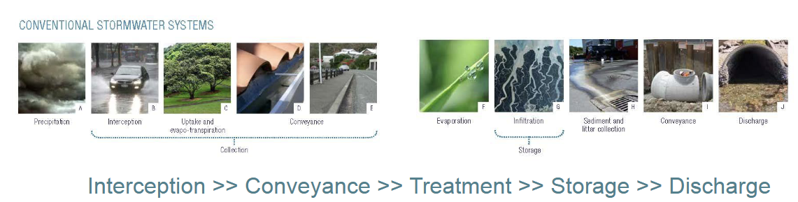
Another way of thinking about this that comes from the what a sense of design. is thinking about how you intercept. So where you create your 1st contact with the water, from a build perspective, how you convey it, so how you might move or shift or move it across the ground in an organised fashion, how you might treat it for pollutants or materials that it might pick up, how you might capture or store it. For future use or to slow its movement so that it can be distributed or outlated in a more safe manner, and then how do you discharge it?
Except everyone knows that you don't go swimming in Auckland Harbour, from the Waitewhata, after heavy rain, because we haven't nailed this yet. And our overflow system, our stop brake system is that it flows into the sewage system. And then that overflows the sewage system and then the sewage system and the stormwater system will flow out into the harbour. Because what's happened is that our conveyance doesn't actually reflect the true water capacity that it needs to across either the storm water system or the sewage system. And our street treatment and storage capacity does not reflect the flood return or the flood level impacts of our modern context, our planet changing context. And our discharge system is old-fashioned and still uses the ocean and waterways as primary discharge points. Despite the fact that as humans, we know that fundamentally that's wrong. But we just don't like putting money where our mouth is.
Slow-spread-soak essentially fits into that same kind of concept, but it takes a more ecosystem services level approach, a soft infrastructure or a nature-based solutions approach to this challenge, rather than building things to intercept, convey, treat, store, and discharge, it thinks about other ways in which we might action those activities within the wider landscape environment, or even within our buildings. And there's some really, this is all from the water sensitive design to stormwater guide. I thoroughly encourage you to go and read it because the drawings are beautiful. But here is green, blue green infrastructure. An ecosystem service focussed approach, nature-based solution, and a catchment level. Looking at water sensitive responses. understanding they waterways want to have a delta system. They want to spread out when they get to the sea. Have shallow shoally environments with lots of mangroves and wetland species, that when you have vegetated edges and enough room for that water to flood, and to soak, and to slow. Then the city, the built infrastructures, are less likely to be threatened by that water in times of flood or high rainfall or other threat potential environments. And when our hinterlands are highly vegetated, chances are that what gets down to the cities because most of our cities are usually in that Goldilocks zone, where it's flatter. There will be less water moving across the ground anyway.
So when we clear all the forestry, and a classic example of this happening is what's been happening on the east coast across the most recent cyclones. When we clear all that forestry, there's nothing slowing that water down and it is picking up everything along the way and the endpoint of that is in the sea. But before it gets there, it takes out every bridge, every road, every house, every community, every other tree that's still standing, and it deposits it all in the beach environment. And in the process, all the sediment goes there and all the bent thick sea systems all die because they get smothered. At the foundation of that is just really poor forestry practice and most of those forests were planted in response to that being farmland previously and the water doing the same thing, but just taking the hillsides with it. So it's a classic example of what was a nature-based solution then proving to be not the right one unfortunately but economically, really valuable. So how do you negotiate that complexity at a landscape scale? So the planning scales are at a regional city scale. and a catchment or community scale, and I would say catchment and community scale, because often what you have is multiple communities within a catchment, and sometimes even multiple catchments within a community. And then at a site or neighbourhood scale, and then write the way down to the lot or the block scale or the scale of the building. And so when you think about an urban transect, or in your case, it might be a catchment transfect. These are the kinds of things that you need to think about. Where's the water coming from? What kind of landscapes is it moving across? And, what are we protecting in terms of the human-built stuff, but also what are we protecting in terms of the way that the water needs to move and the ecosystems and the ecosystems services that it provides that we need to acknowledge and value and consider in the way we design?
Understanding what the typology is of the catchment and the different zones within the catchment is really important, There’s an upper catchment condition. There's a mid-catchment condition, and there's a lower catchment condition, and they have some kind of basic principles that you can say, well, the upper catchment is typically the steepest part at the top of the catchment, and the middle catchment is tends to be the kind of flattest part, but it's kind of sufficiently distant from the most flood prone zone, that it's usually where most of the inhabitation happens. And then the lower catchment is the most flood prone zone within the catchment. But there are lots of unique things about these different stuff, places within the catchment that you need to understand about your water system. So if we think about Savai’i where your site is, the upper catchment is almost completely vegetated and uninhabited. The mid-zone is predominantly farmed and not hugely inhabited. Although the archeological evidence suggests it once was heavily inhabited. And then the lower catchment zone is now most inhabited, but archeologically less so over time.And it also has the complexity of having all of the infrastructure at that lower zone now. The roads are there, the is not real. So the system is there. But the electricity system, they all exist around that lower catchment zone. So that's unique to your catchment is somebody, And it's steep. And it's volcanic. And so those all have different factors in terms of the absorbancy capacity. level, Sea level rise, or tsunami, or even just storm surge impacts, but there's also lots of other things that are happening in that tropical environment, like bleaching of coral reef systems, meaning that there's a kind of a collapse of the protective shallow seas environment. We're seeing saltwater intrusion. So a lot of the springs or puna, that exists within those lower catchment zones, get salt water coming into them, so they're no longer able to provide the fresh water needs for those communities that are settled down low. And also the one road in, one road out factor can be really problematic.
If you have erosive events that take those roads out as a result of the infrastructure not being resilient to that water movement. So that's a classic example of roads crossing water systems, particularly key roads crossing water systems, as a classic human mal adaption. We can build it better. We'll just make the water go underneath it through this tiny little colvent. I'd say that about 70% of ahu kotahi or NZTAs, roading lows at the moment are about underestimating water. Potholes are another classic example.
So when we think about how we design our environments, we need to think about how we can start to replicate or mimic some of the things that water needs to be a healthy system. And so green roofs, green walls, ways in which we can replicate those absorbent surfaces that have multiple COVID benefits. They also provide air purification, they provide connection to nature, which has huge well-being value. They provide a habitat for broader flora and fauna, that live with us in these communities. They provide cooling in urban environments that's really useful. In some, in some instances, they provide crops. They provide recreational opportunities. So they had numerous co-benefits.
Similarly, things like open spaces, stream systems, less , non-pervious surfaces, have many co-benefits for us at a community scale. So this is an example of a flood park. thinking about how we use our community amenities to support flood resilience. Recognising that in the middle of a flood, it's unlikely that we're going to need to play football. Or at least it's not so immediate that we need to play football, that we can't allow it to flood. If we've designed it so that we can still play football after the flood that's finished. And so, again, it's thinking about how we can design these co-benefits into our environments and to our urban contexts, to increase our resilience. But also to increase our well-being and community outcomes. So things like wetlands, which used to be looked down upon in a developing colonial New Zealand. Wetlands were problematic because you couldn't put cows or sheep on them to graze, and you couldn't move across them easily. You certainly couldn't move an army across them easily. And also, most Europeans didn't understand how maori could collect food or housing materials from them that they could use. They didn't see that value. And so wetlands, and this is not just an alternate all thing. This is a worldwide thing. Wetlands were seen as problematic ground that needed to be drained, organised into smaller canal river systems, so that farming, large scale agriculture, built environment stuff could happen instead. But in the process, we lost our capacity to soak. We lost our capacity to filter, and we lost our capacity to live alongside or with water systems so we're starting to reintroduce this stuff now. We're having to remember and reconstruct and redeploy and refer to nature and the process.
And we're also starting to understand how these things go together. So we have individual actions. that we can that we can deploy, but we need to understand how they work together as a system. Because sometimes one isn't enough. And sometimes 2 isn't enough. And sometimes 3 is just right, and sometimes 4 is enough. But there are lots of different scales at which they can happen and lots of which of ways, lots of different ways in which they can be deployed, so they could be constructive things. They could be natural things, they could be making space for things. Could be about removing things or it could be about putting things in place. So thinking about like how architecture can be part of the story.
It’s not just buildings but other infrastructure, built infrastructure that can start to perform some of these things as well. So highways, car parking, buildings, et cetera. Highline park in New York, that's a classic example of infrastructure being repurposed in this manner. Quay Street It was done by Isthmus Group, and it's a series of really beautiful rain gardens. that were installed in recognition that a lot of water moves across our city and just hits the harbour and takes all the nasties in with it. And so not only are we capturing the water here and using the vegetation and the rain gardens to filter it before it arrives at the water. There was also a really lovely installation that happened in the water below the wharfs, of receding the muscles that do huge filter load work in our harbours. And it's one of the reasons why it's possible to swim in that little pool that was constructed,, brown pool is because some of these efforts and interrupting the flow of polluted overland runoff into the harbour.
And so here are some examples. of what some of these rain garden systems look like. They add lots of value, not just to the water system into these communities. Waitangi Park, the really famous New Zealand example of a constructed wetland system that was as much about showing the Wellington community predominantly, but it's kind of got national appeal now what a wetland would have looked like in this environment and how lovely it could be as an open space to spend time in. And so initially, this was less about high functioning. And it has grown into itself and been adjusted and adapted over time to become more functioning. But this was predominantly demonstration work in the 1st instance. But the co-benefits were that it was also doing filtering work as well as being a visible demonstration of what things could be like. Now you can now swim off these Wellington wharfs in an area that you would never have considered doing so beforehand.
Thinking about how a dedicated park environment, um, open water system, vegetated environment, provides not just amenity in a public space for the surrounding community, but also serves a purpose to mitigate flood challenges, particularly for the adjacent sports fields., which was this way.
This Wairau catchment. This is, interestingly, in the anniversary floods, this went completely underwater. They’ve just gone a huge amount of region work in this particular zone. This is part of a much bigger process of flood resilience building in the wider attachment that is being undertaken by healthy waters at the moment and they're basically following the same principle. So another example of this is what was done at Tiara Awataha and Northcote, flood prone environment and this particular neighbourhood, was in the process of increasing in population by about 50,000 residents due to a partnership between Kainga Ora, and Auckland Urban Design Office. Auckland Transport, and a couple of others, big partnered organisations. To increase housing availability, affordable housing availability. And this has resulted in a huge number of mid-rise apartments being built in this area, but it also recognised that a lot of us land was flood prone. And so they built infrastructure to respond to that. So 1st of all, they understood it at a region scale. How did this fit into what was going on in the broader environment? What other things did it connect to? And thinking about not just in terms of how the water move, but also in terms of how people move across these spaces. So how do we create a recreational network that connects people to their open spaces as well. Because now the majority of the residents within the zone are living in high-rise buildings or mid-rise buildings. They're kind of 6-7 stories. And so they don't touch the ground at home in the same way. So the recreational and the green networks become increasingly important.