EAS 209 - Lecture 31
Joseph Burr Tyrrell
Lived from 1858–1957.
Namesake of the Royal Tyrrell Museum.
Conducted extensive geological work in Canada.
Worked on:
Cretaceous geology.
Fossil discoveries.
Arctic exploration.
Geological Survey of Canada projects.
Originally trained as a lawyer.
Contracted typhoid fever.
Disease damaged one of his lungs.
At the time, fresh air was believed to aid recovery from lung damage.
Switched career paths from law to geology.
Pursued fieldwork partly because it kept him outdoors.
Worked extensively in:
Arctic Canada.
Alberta.
Drumheller region.
Participated in activities associated with the gold rush.
Became independently wealthy.
Achieved considerable financial success.
Associated with the eventual establishment of the museum bearing his name.
Remembered as an important Canadian geologist and fossil collector.
Transition from Previous Lecture
Previous lecture ended with:
McMurray Formation.
The McMurray Formation represents a meandering stream plus deltaic package from Shield drainage.
Gething Formation.
Blue Sky Formation.
Lower Mannville Group.
Discussion centered on paleo-highs created by the sub-Cretaceous unconformity.
Paleo-highs consisted largely of exposed:
Devonian rocks.
Carboniferous rocks.
These exposed ridges influenced sediment distribution during early Cretaceous deposition.
The "Spine" of the Paleozoic
Exposed Devonian and Carboniferous rocks formed elevated ridges.
These ridges are referred to as the "Spine of the Paleozoic."
Represented exposed structural highs during early Cretaceous time.
Influenced where sediment accumulated.
Separated depositional systems such as:
McMurray.
Gething.
Blue Sky.
McMurray Formation Overview
Located primarily in northeastern Alberta.
Composed mainly of sandstone.
Sandstone is:
Clean.
Well sorted.
Dominantly quartz-rich.
Contains very little mud.
Contains few other minerals besides quartz.
Represents deposition in large river systems.
Early Cretaceous Paleogeography
Rocky Mountains had already formed.
Mountains supplied sediment eastward.
Sediment moved from the mountain belt into the foreland basin.
Ocean occupied the eastern portion of the basin.
Most of Alberta initially remained terrestrial.
Depositional environments included:
Fluvial plains.
River systems.
Deltas.
Exposed paleo-highs remained above surrounding sediment.
Fluvial Plains
Large low-relief landscapes crossed by rivers.
Comparable in general appearance to modern river valleys.
Dominated by:
Rivers.
Floodplains.
Vegetation.
Major setting for McMurray deposition.
Sediment transported across the landscape toward the ocean.
Deltaic Environments
Formed where rivers entered the ocean.
Rivers deposited sediment at the shoreline.
Sediment accumulation produced deltas.
Delta systems prograded into marine waters.
Served as transition zones between:
Continental environments.
Marine environments.
Meandering Rivers
Rivers migrated laterally across floodplains.
Channels shifted position through time.
Meanders occasionally became abandoned.
Rivers could:
Change course.
Cut off bends.
Create abandoned channels.
Meandering river deposits form characteristic sedimentary packages.
McMurray Oil Sands Region
Located primarily in northeastern Alberta.
Oil-sand deposits occur around McMurray depositional systems.
Distribution controlled by:
Ancient river systems.
Paleo-highs.
Basin topography.

Bitumen and Oil Sands
McMurray sands originally resembled ordinary quartz sand.
Clean sandstone is naturally:
Light-colored.
Tan.
Quartz-ric
h.
Modern oil sands appear black because they contain bitumen.
Bitumen is:
Very viscous.
Heavy oil.
Rich in long hydrocarbon chains.
Bitumen coats sediment grains.
Dark coloration obscures sedimentary structures.
Oil-sand mining involves:
Excavating bitumen-rich sand.
Processing it to extract hydrocarbons.
Oil sands constitute a major source of Alberta petroleum production.
Late McMurray Sea-Level Rise
Sea level began rising during late McMurray time.
Previously terrestrial environments became flooded.
Marks progression toward marine influence.
Represents a transgression.
Brackish Bays
Forms when you have fluvial waters being shed into a bay where there is ocean waters mixing. Additionally, there is freshwater being added.
Lower salinity.
Formed when seawater flooded former fluvial environments.
Freshwater and marine water mixed together.
Salinity became lower than normal marine conditions.
Brackish environments have:
Variable salinity.
Reduced biodiversity.
Lower abundance of organisms.
Many marine organisms struggle to tolerate salinity fluctuations.
Only specialized organisms thrive under such conditions.
Low diversity + low abundance of organisms in these environments.
Biological Indicators of Brackish Conditions
Certain trace fossils indicate brackish environments.
Specific burrowing organisms tolerate variable salinity.
Worm-produced burrows can be used as environmental indicators.
Trace fossils therefore assist in identifying ancient brackish bays.
Transformation of the McMurray Landscape
Original fluvial plain became inundated.
Delta systems were drowned by rising sea level.
Areas formerly occupied by rivers became brackish bays.
Marine waters expanded inland.
Paleo-highs remained exposed initially despite flooding.
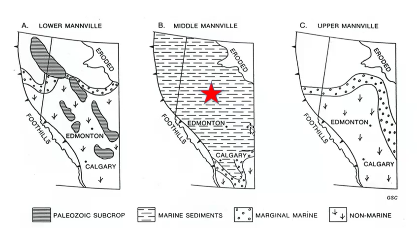
Lower, Middle, and Upper Mannville Evolution
Lower Mannville
Dominated by:
Meandering rivers.
Fluvial plains.
Delta systems.
Includes:
McMurray.
Gething.
Related deposits.
Paleo-highs remained exposed.
Oil-sand reservoirs formed in river sandstones.
Middle Mannville
Marine transgression flooded the basin.
Fluvial environments became submerged.
Brackish bays formed initially.
Continued sea-level rise eventually produced fully marine conditions.
Shales accumulated over former river deposits.
Upper Mannville
Regression occurred.
Sea retreated.
Fluvial environments expanded again.
Rivers once again dominated the landscape.
Major difference from Lower Mannville:
Paleo-highs were now buried.
Exposed Devonian and Carboniferous ridges no longer influenced deposition.
Upper Mannville Paleogeography
This records regression accompanying retreat of the Boreal Sea northwards.
At the same time, a northward advance of the Gulfing Sea is seen.
Boreal Sea retreated northward.
Rivers and floodplains expanded across Alberta.
Sediment supplied by:
Nelson Uplift.
Cassiar-Omineca Uplift.
Nonmarine conditions became widespread.
Marine environments remained farther away.
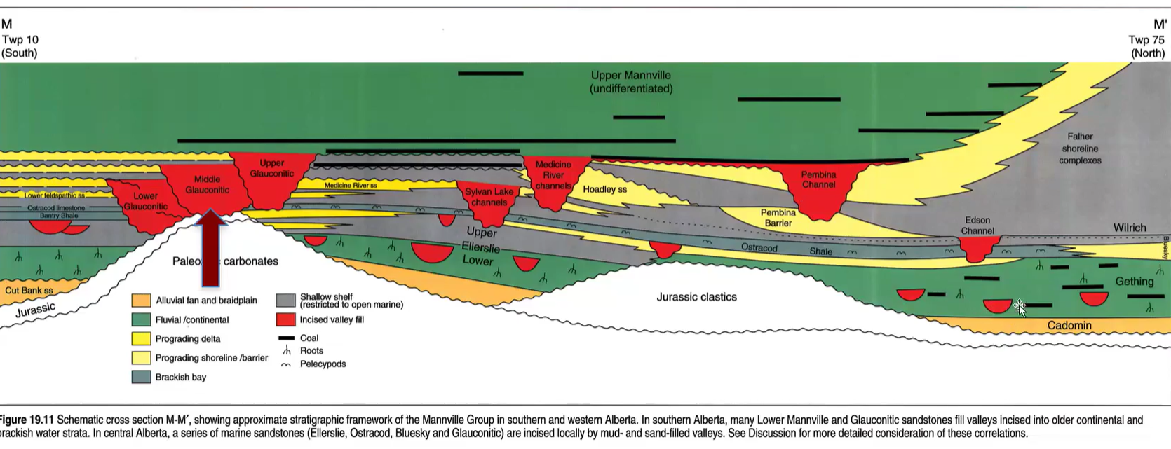
Incised Valleys
More complex than the channels on the above image. They are wider and deeper.
Large erosional valleys cut into older deposits.
Much larger than ordinary river channels.
Characterized by:
Greater depth.
Greater width.
Formed during falling sea level.
The river tries to keep pace with what the sea level is doing.
As sea level falls, the river cuts down to keep pace with sea level falling. It incises down and makes incised valleys.
Relationship Between Sea Level and River Erosion
Rivers attempt to maintain equilibrium with ocean level.
Falling sea level lowers base level.
Rivers respond by eroding downward.
Downcutting creates deep valleys.
Continued sea-level fall increases incision.

Formation of Incised Valleys
Initial stage:
River meanders across floodplain.
Sea level relatively stable.
Sea level begins falling.
River erodes downward.
Valley deepens.
Meandering continues during incision.
Side-to-side migration widens the valley.
Result is a broad incised valley rather than a narrow canyon.
Valley Filling During Sea-Level Rise
Sea level begins rising again.
Accommodation space increases.
Rivers begin depositing sediment into valleys.
Valleys progressively fill.
Initial fill consists of fluvial deposits.
Continued transgression allows marine deposits to enter valleys.
Marine sediments eventually overlie river sediments.

Also coals that accumulated near the top… as the delta prograded (advanced into the basin).
Upper Mannville Deposits
Nonmarine conditions returned after marine retreat.
Fluvial systems expanded.
Coal-forming swamps developed.
Additional heavy-oil accumulations formed.
Shield-derived sediment contributed to deposition.
Grand Rapids Formation
Part of the Upper Mannville succession.
Sandstones differ from McMurray sandstones.
Contain abundant lithic fragments.
Lithic fragments appear as dark speckles.
Indicates sediment derived partly from the Canadian Shield.
Less compositionally mature than McMurray sandstone.
Coal Formation in Upper Mannville
Swamp environments became widespread.
Plant material accumulated.
Burial preserved organic matter.
Organic-rich deposits eventually became coal seams.

Colorado Group
This is a huge clastic wedge comprising up to 800m of marine shales, with relatively thin and restricted sand and conglomerate packages. It also thickens to the NW.
Mannville Group deposition concluded.
Next major stratigraphic package is the Colorado Group.
Colorado Group contains important petroleum reservoirs.
Includes:
Viking Formation.
Fish Scales Formation.
Other marine units.
Colorado Group Overview
Dominated by shale deposition.
Contains enormous thicknesses of mudstone.
Shale reaches approximately 800 metres thick.
Represents prolonged marine conditions.
Indicates widespread inundation of the basin.
Colorado Group Shales
Consist primarily of mud.
Contain relatively little coarse sediment.
Reflect low-energy marine conditions.
Much of the earlier mountain-derived coarse sediment had already been deposited.
Shield-derived sediment also became less significant.
The lack of coarse sediment is due primarily to reduced tectonic uplift in the orogen (rockies).
There was no apparent Shield source at this time either.
Bifurcated in North America.

Western Interior Seaway
A general eustatic sea level rise wherein the Boreal and Gulf Seas met for the first time.
Sea level rose dramatically.
Marine waters connected north and south.
Seaway linked Arctic waters with the Gulf of Mexico.
Also called:
Western Interior Seaway.
Cretaceous Epeiric Sea.
Divided North America into two landmasses.
Created a continent-spanning inland sea.
Geography of the Western Interior Seaway
Cordillera occupied western North America.
Canadian Shield occupied eastern North America.
Large marine basin lay between them.
Alberta was submerged beneath marine waters.
Marine deposition dominated much of the region.
Marine Life of the Seaway
Marine reptiles included mosasaurs.
Marine ecosystems contained ammonites.
Other marine organisms flourished.
Many Alberta Cretaceous fossils are marine rather than dinosaurian.
Marine fossils dominate large portions of the stratigraphic record.
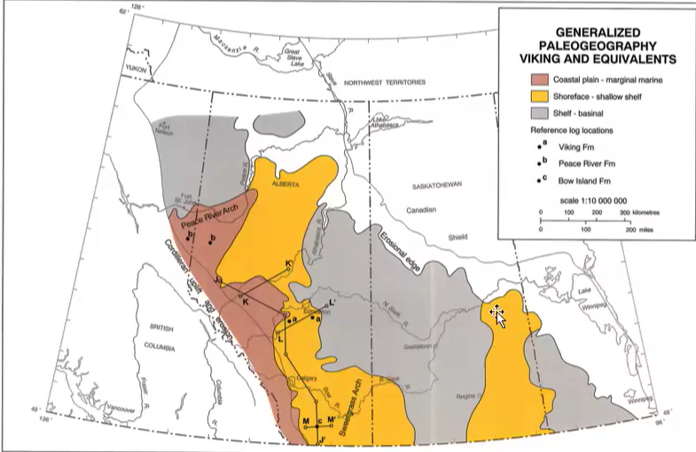
Viking Formation
Important sandstone unit within the Colorado Group.
Represents a preserved shoreline deposit.
Equivalent to a beach or shoreface environment.
Occurs within thick marine shales.
Forms a relatively narrow sandstone body surrounded by mudstone.
Rock is dark grey/black with white stripes… → means it has lithic components.
Viking Depositional Environment
Coastal plain located landward.
Shoreface sand accumulated along the shoreline.
Marine waters occupied offshore regions.
Represents a snapshot of shoreline position during Colorado Group time.
Joffre Oil Field
Associated with Viking Formation production.
Viking sandstone contains lithic fragments.
Sandstone displays a "salt-and-pepper" appearance.
Indicates mixed mineral composition.
Fish Scales Formation
The Colorado Group includes the boundary between the Lower and Upper Cretaceous, recorded by a zone of fish remains, the Base of Fish Scales.
Important marker bed within the Colorado Group.
Contains abundant fossil fish scales.
Fish scales are phosphate-rich.
Phosphate concentration makes the unit highly radioactive.
Produces a distinctive gamma-ray signature.
Used extensively for stratigraphic correlation.
Fish Scale Fossils
Preserved as dark phosphate-rich particles.
Occur throughout the formation.
Allow recognition of the unit across Alberta.
Marker bed extends across much of the province.
Crowsnest Volcanics
Evidence exists for Cretaceous volcanic activity.
Just younger than the Lower/Upper Cretaceous boundary is the Crowsnest Volcanics.
Located near:
Coleman.
Blairmore.
Crowsnest Pass.
Volcanism occurred during deposition of surrounding sediments.
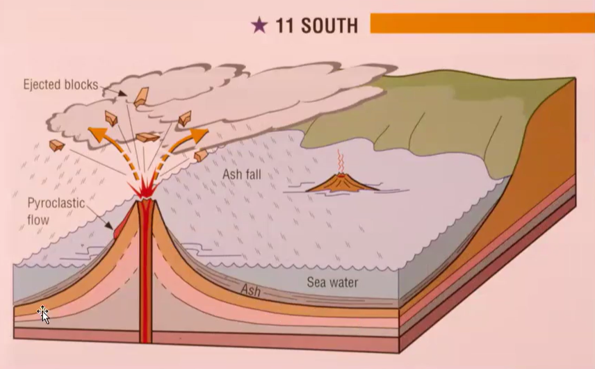
Volcanic Processes
Volcanoes erupted:
Ash.
Rock fragments.
Pyroclastic material.
Pyroclastic flows moved downslope.
Ash clouds spread over wide regions.
Ash eventually settled and accumulated.
Preservation of Volcanic Ash
Ash deposited on land was often eroded away.
Ash deposited in marine environments had better preservation potential.
Marine sediments therefore preserve evidence of volcanic eruptions.
Crowsnest Volcanic Rocks
Contain large crystals.
Porphyritic texture indicates crystallization within the Earth.
Some rocks contain:
Analcime.
Garnet in certain locations.
Radiometric ages indicate approximately 100 million years.

Cardium Formation
Another important sandstone unit.
Represents a shoreline deposit similar to the Viking.
Formed at a different time than the Viking.
Associated with petroleum accumulations.
Characteristics of the Cardium
Quartz-rich sandstone.
Relatively low lithic content.
Well-sorted.
Commonly cleaner than Viking sandstones.
Contains extensive shoreline sand bodies.
Chert-rich.
Cardium Reservoirs
Oil accumulations often occur within shoreline sand deposits.
Large sand bodies provide good reservoir characteristics.
Many producing fields correspond to preserved beach deposits.
Cardium Conglomerates
Occur near mountain-front regions.
Represent continued erosion of western highlands.
Rich in chert clasts.
Chert likely derived from older Permian deposits.

Post-Colorado Group
The Peace River Arch reappeared/emerged.
Basin geometry resembled a wedge.
Marine conditions dominated northeastern areas.
Thickness varied across the basin.
Bearpaw Formation
Represents the final major marine incursion.
Came from the South.
A major feature is the Upper Cretaceous Bearpaw Formation, which represents the last marine inundation of Alberta (by a Gulfian, not Boreal Sea).
Last significant seaway affecting Alberta.
Different from earlier marine invasions.
Unique Origin of the Bearpaw Sea
Most earlier Cretaceous marine invasions came from the north.
Bearpaw marine waters came from the south.
Derived from the Gulf of Mexico.
Represents a Gulfian rather than Boreal seaway.

Bearpaw Paleogeography
Western Interior Seaway had largely disappeared.
Most of North America was once again connected by land.
Bearpaw Sea represented only a remnant marine embayment.
Eventually retreated completely.
End of Major Marine Conditions
Bearpaw transgression marks the last significant marine flooding.
After retreat, Alberta remained terrestrial.
No later seaway inundated the province on a comparable scale.
Edmonton Group
Developed after Bearpaw retreat.
Dominated by fluvial conditions.
Represents final stages of Cretaceous sedimentation.
Belly River Group
Includes deposits associated with Dinosaur Provincial Park.
Important for dinosaur fossils.
Preserves:
Hadrosaurs.
Other dinosaurs.
Continental environments.
Pascapoo Formation
Paleocene age.
Lies above Cretaceous deposits.
Dominated largely by sandstone.
Important groundwater aquifer.
Major source of drinking water in Alberta.
Bearpaw Fossils
Contains oyster beds.
Marine fossils record the final Gulf-derived seaway.
Examples displayed in ESB collections.
Horseshoe Canyon Formation
Overlies the Bearpaw Formation.
Represents return to fluvial environments.
Characterized by:
River deposits.
Floodplains.
Swamps.
Marks continued regression of the sea.
Bearpaw–Horseshoe Canyon Contact
Records transition from:
Marine conditions.
Continental conditions.
Commonly visible in badlands exposures.
Bearpaw is typically:
Dark.
Fine-grained.
Horseshoe Canyon is generally:
Sandier.
More fluvial.
Hadrosaur Fossils
Hadrosaurs are duck-billed dinosaurs.
Fossil bones commonly become associated with ironstone.
Organic decay alters local geochemistry.
Redox boundaries promote iron precipitation.
Iron minerals preserve and highlight fossil material.
Unionid Fossils
Freshwater bivalves.
Common in fluvial deposits.
Occur in Horseshoe Canyon exposures.
Similar fossils were discussed previously at Dinosaur Provincial Park.
Bentonite
Produced from altered volcanic ash.
Derived from eruptions such as those associated with the Crowsnest volcanics.
Extremely slippery when wet.
Develops a popcorn-like texture when dry.
Commonly encountered in badlands exposures.
Plant Fossils
Bentonite and associated deposits preserve plant material.
Fossils include:
Conifers.
Tree trunks.
Demonstrate existence of forested environments during deposition.
Coal in Horseshoe Canyon
Horseshow Canyon Formation, significant for 5 workable seams of sub-bituminous (mid-rank) coal, no longer active (i.e. petrified tree stump and coal seam, East Coulee, AB).
Swamp environments accumulated plant material.
Organic matter became coal.
Coal seams occur throughout the formation.
Coal deposits reflect widespread wetlands.
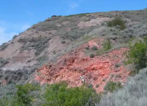
Clinker
Produced when coal seams burn.
Appears:
Pink.
Salmon-colored.
Red.
Common in Drumheller-region exposures.
Forms when coal is altered by fire.
Fires may originate from:
Lightning strikes.
Natural ignition.
Burning can continue underground for extended periods.
Summary of Cretaceous Evolution
Early Mannville
Fluvial plains.
Meandering rivers.
Deltas.
Exposed paleo-highs.
Oil-sand deposition.
Middle Mannville
Marine flooding.
Brackish bays.
Marine shale accumulation.
Upper Mannville
Sea retreats.
Fluvial conditions return.
Paleo-highs buried.
Colorado Group
Massive marine transgression.
Western Interior Seaway develops.
Approximately 800 m of shale deposited.
Viking and Cardium shorelines preserved.
Belly River Group
Continental environments.
Dinosaur preservation.
Dinosaur Provincial Park deposits.
Bearpaw Formation
Final marine incursion.
Derived from Gulf of Mexico waters.
Last major seaway in Alberta.
Edmonton Group
Return to terrestrial conditions.
Rivers, floodplains, and swamps dominate.
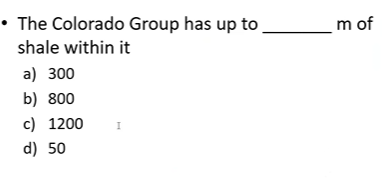
ANS: 800