Geography
Geography
Introduction to geography
Nature of geography
The human/cultural and physical environment
Human environment refers to the artificial environment that is created by humans.
The cultural environment is a business concept that helps comprehend a group of people's or society's norms and collective ideas based on their culture, religion, location, nationality, language
The Physical Environment refers to the external surroundings and conditions in which we live and which influence a person's health. E.g. lakes and schools;.
Geographic tools e.g. types of maps
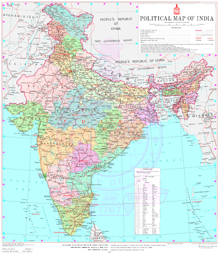
Topographic map - political map
SPICESS BOLTSS
Space Border
Place Orientation
Interconnection Legend
Change Title
Environment Scale
Sustainability Source
Scale
Skills
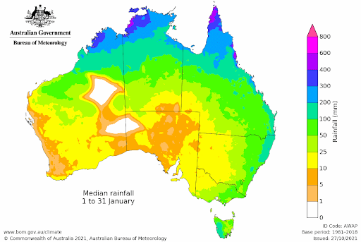
Climate Graphs
Continents and oceans
Continents
North america
South america
Australia
Asia
Europe
Africa
Antarctica
Oceans
Arctic
North Atlantic
South Atlantic
North Pacific
South Pacific
Indian
Southern oceans.
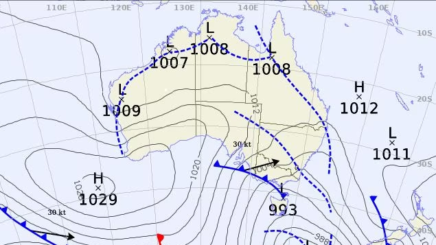
Synoptic charts
hPa (saying what the air pressure is like)
Isobars show the air pressure measured in hPa use high elevation
High pressure - sun, blue sky, calm wind Clockwise
Low pressure - unstable, rain, wind (strong if isobars are together) Anticlockwise
Latitude and longitude
Longitude measures distance east or west of the prime meridian.
Latitude measures the distance north or south of the equator.
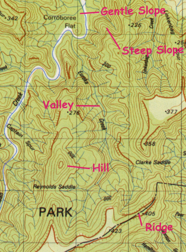
Topographic maps: AR and GR, contour lines, direction, scale
Contour lines only on topographic maps
Bearings
Figure out one's position or situation relative to one's surroundings.
Sketch maps
An outline map drawn from observation rather than from exact survey measurements and showing only the main features of the area.
Landscapes and landforms
Introduction to landscapes/landforms
A landscape is part of Earth's surface that can be viewed at one time from one place.
A landform is a feature on Earth's surface that is part of the terrain. Mountains, hills, plateaus, and plains are the four major types of landforms.
Different types of landscapes
Mountain landscape Steep, stopping slides and sharp rounded ridges and a high point called a peak or a summit. Formed by tectonic plates on earth's surface pushing against each other. 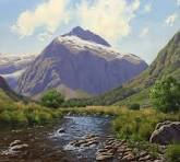 |
Desert landscape Dunes towering bare peaks, flat topped rock formations and smoothly polished canyons. Mesas, butter canyons, arroyos, arches, rock pedestals. 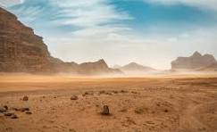 |
Rainforest landscape Wet misty with high rainfalls. Mountains, valleys and floodplains. 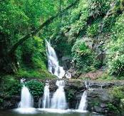 |
Grassland landscape Area in which the vegetation is dominated by a nearby continuous cover of grass Prairies and steppes.  |
Polar landscape Cold and dry deserts ti brush and lush tundra plant on frozen soil to ice caps. Tundra, permafrost, lakes, rivers, glaciers, ice sheets and ice sleeves, 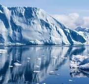 |
Karst landscape Enclosed depressions sinkholes, sinking streams and springs. Caves sinkholes and underground streams.  |
Aquatic landscape Seas, oceans, lakes, rivers, wetlands, marshes, lagoons, streams and swamps. Lakes ponds, streams, rivers and swamps. 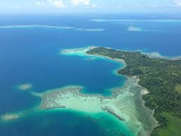 |
Different landforms (Coastal)
Landforms E.g.
Sand
Ocean
Rocks
Shells
Cliffs
Trees
Sand dune
Beaches
Sea Stacks
Rock pools
Arches
Bays
Headland
Cliff face
Sea stocks
Beach front
Rock platforms
How do we use the coast?
We swim in the ocean and gather food
How do landscapes form?
Waves, wind and tectonic plates (earthquakes) make landscapes.
How are coastal landscapes shaped?
Where the water meets the land form and the rain.
12 Apostles
How were the 12 apostles formed?
They were formed by erosion. The harsh weather conditions from the southern ocean helped as well.
8 Fascinating Facts about the Great Ocean Road and 12 Apostles
It is the world's largest war memorial. ...
It's 243 kilometres long. ...
There are at least 638 known shipwrecks lying at the bottom of the ocean along the Great Ocean Road. ...
The 12 Apostles were originally called the Sow and Piglets. ...
But there were never 12 Apostles.
Values of landscapes/landforms
cultural value
spiritual value
aesthetic value
economic value.
Protection/management of landscapes/landforms
COLLAROY
It is in NSW
40 mins from st caths
HOW TO PROTECT
Beach scraping
Rechaping beach and dune landforms.
Beach nourishment
Adding sediment onto directly adjacent to an eroding beach
Sand recycling
Reusing sand
Dune building
Making a man made dune
Artificial reefs
A man made beef that has characteristics of a real one
Groynes
Rock or geotextile material begs that trap sand
Seawalls
A structure made of concrete.
AREA AROUND COLLAROY
Collaroy Beach is partly protected from the wind and swell from the south, making it a perfect beach for beginners, swimmers and families. There is also a saltwater ocean pool however, if you prefer a smaller and quieter beach, just a short walk around the corner you will find Fishermans and Long Reef Beach.
SHOULD WE PROTECT COLLAROY?
Collaroy had erosion from coastal storms on the northern beaches and we have to protect it.
SIERRA LEONE
It is in west africa
Near guinea, liberia and ghana
Lots of deforestation
Population 8.06 million (2022)
NUSA
In queensland
Geomorphic hazards.
What is it
A geomorphic hazard is a process or event in the physical environment that has the potential to negatively affect humans, their activities or the environment.
Examples
Volcanic eruptions
A volcanic eruption is the expulsion of gases, rock fragments, and/or molten lava from within the Earth through a vent onto the Earth's surface or into the atmosphere.
Earthquake
the sudden release of strain energy in the Earth's crust, resulting in waves of shaking that radiate outwards from the earthquake source.
Tsunami
Tsunamis are giant waves caused by earthquakes or volcanic eruptions under the sea.
Landslide
a mass movement of material, such as rock, earth or debris, down a slope.
Place and liveability
What is liveability?
Liveability can be defined as: the qualities and characteristics of a place that support wellbeing and quality of life.
Factors affecting liveability
Urban amenity
Housing
Transport
Air and water quality
Access to the natural environment
Heritage
Social and aesthetic aspects.
Enhancing liveability
Access to fresh water
Food
Housing
Transport
Health care
Education
Safe and stable built
Natural environment.
Sustainability
Meeting the needs of the present without compromising the ability of future generations to meet their own needs
Water in the world
Types of resources: natural, renewable, continuous, non-renewable
Natural: oceans, rivers, and lakes.
Renewable resources: Recycled water e.g. using the water from your shower for the toilet, Aquifers to clean water and then can be used again.
Continuous: The amount of water on Earth will always remain the same. We can't run out of water because water continuously works its way through the water cycle.
Non renewable: Non-renewable water resources are not replenished at all or for a very long time by nature. This includes the so-called fossil waters.
Water cycle
Condensation - It is the process by which a gas Changes into a liquid
Precipitation - Precipitation is any liquid or frozen water that forms in the atmosphere and falls back to the earth.
Transpiration
Infiltration
Interpreting weather maps
Australia’s water resources
Rainwater.
Groundwater – This includes water bodies like Wells and Springs.
Surface water – This includes different water bodies like Reservoirs, Rivers, Streams, Ponds, Lakes and Tanks.
Hydrological hazard: impacts
A 'Hydrological Hazard' refers to a type of natural disaster that involves water-related events. E.g.
inland flooding
coastal surge
wet mass movements like landslides
Avalanches
subsidence
Practice test
Yearly Examination: Introduction to Geography
Student Name: Isabel Rose-Innes
Date: ______________________
Instructions:
Answer all questions in the space provided.
Use diagrams where necessary to illustrate your answers.
Ensure your answers are clear and concise.
The exam is worth a total of 100 points.
Section 1: Nature of Geography (15 points)
1.1 Human and Cultural Environment (5 points)
Define the human environment and give an example. (3 points)
Explain the concept of the cultural environment and its significance. (2 points)
1.2 Physical Environment (5 points)
What is the physical environment? Provide examples of features found in this category. (5 points)
1.3 Geographic Tools (5 points)
List two types of maps and describe their purposes. (3 points)
a) ________________________________________________________
b) ________________________________________________________Explain the SPICESS and BOLTSS acronyms. (2 points)
Section 2: Geographic Skills (20 points)
2.1 Climate Graphs and Synoptic Charts (10 points)
Describe how to interpret a climate graph. (5 points)
Explain what isobars indicate on a synoptic chart. (5 points)
2.2 Latitude and Longitude (5 points)
How do latitude and longitude help in determining location? (5 points)
2.3 Population Pyramids (5 points)
What is a population pyramid, and what information does it convey? (5 points)
Section 3: Landscapes and Landforms (20 points)
3.1 Types of Landscapes (10 points)
Describe the characteristics of a mountain landscape. (5 points)
Identify features of a desert landscape. (5 points)
3.2 Coastal Landforms (10 points)
List and describe three coastal landforms. (6 points)
a) ________________________________________________________
b) ________________________________________________________
c) ________________________________________________________How are coastal landscapes shaped? (4 points)
Section 4: Values and Protection of Landscapes (15 points)
4.1 Values of Landscapes (5 points)
Discuss the different values of landscapes (cultural, spiritual, aesthetic, economic). (5 points)
4.2 Protection and Management (5 points)
What strategies can be used to protect coastal landscapes? (5 points)
4.3 Case Study: Collaroy (5 points)
Describe the features of Collaroy Beach and discuss whether it should be protected from erosion. (5 points)
Section 5: Geomorphic Hazards (10 points)
5.1 Definition and Examples (10 points)
What is a geomorphic hazard? Provide three examples. (10 points)
Section 6: Liveability (10 points)
6.1 Understanding Liveability (5 points)
Define liveability and list factors that affect it. (5 points)
6.2 Enhancing Liveability (5 points)
What measures can be taken to enhance livability in urban areas? (5 points)
Section 7: Water Resources (10 points)
7.1 Types of Water Resources (5 points)
Differentiate between natural, renewable, continuous, and non-renewable water resources. (5 points)
7.2 The Water Cycle (5 points)
Explain the stages of the water cycle: condensation, precipitation, transpiration, and infiltration. (5 points)
Section 8: Hydrological Hazards (5 points)
8.1 Hydrological Hazards (5 points)
Define hydrological hazards and provide examples. (5 points)