Earthquakes (2 lectures)
Fundamentals of Earthquakes and Seismicity
Definition of an Earthquake: Earth shaking caused by the rapid release of energy stored within the crust.
Waveform Propagation:
Energy propagates radially outward from the source as an expanding sphere of seismic waves.
This waveform energy is sufficiently powerful to be detected and measured by scientific instruments across the entire globe.
Global Frequency and Scale:
Earthquakes are routine global occurrences that happen every single day.
More than earthquakes occur throughout the Earth each year.
The overwhelming majority of seismic events are minor and cause no surface harm.
Large, high-magnitude earthquakes represent major geological hazards that destroy structural engineering works and cause severe human mortality.
Large earthquakes have caused approximately human fatalities over the last .
Catastrophic earthquakes occur at an average frequency of several hundred events per year worldwide.
Causes of Seismicity: Earthquake activity (seismicity) is triggered by several distinct geological and anthropogenic mechanisms:
Sudden displacement or motion along a newly formed crustal fault.
Sudden slip along an already established, pre-existing fault (the most common cause of earthquakes).
A rapid, sudden transformation in crystalline mineral structure (phase changes under high pressure and temperature).
Subsurface migration and movement of magma within a volcanic conduit or magma chamber.
Explosive volcanic eruptions.
Giant landslides causing massive mass-wasting events.
Extraterrestrial meteorite impacts.
Underground nuclear detonations.
Anatomical Points of an Earthquake:
Hypocenter (Focus): The specific physical location within the subsurface where fault slippage initiates, typically along a fault surface. Seismic body waves emanate outward spherically from this point.
Epicenter: The point on the Earth's subaerial or submarine surface positioned directly vertically above the hypocenter. Surface cartography and seismic maps portray earthquake coordinates based on epicenter locations.
Fault Geometry, Mechanics, and Classification
Fault Definition and Terminology:
A fault is a structural fracture or break in the Earth's crust along which measurable movement and shear displacement have occurred.
Displacement: The total net spatial offset and measure of relative movement between opposing crustal fault blocks.
Fault Trace: The linear intersection where a fault plane cuts or expresses itself along the Earth's surface.
Blind Faults: Subsurface faults that terminate at depth and do not breach the surface; they remain invisible from surface observation.
Active Faults: Fault structures subjected to ongoing tectonic stresses that exhibit modern or recurrent movement.
Inactive Faults: Structural fractures that accommodated tectonic motion exclusively in the geologic past and are currently static.
Nomenclature of Dipping Fault Blocks: On inclined, sloping fault planes, crustal blocks are categorized by structural geometry:
Footwall: The rock block situated physically beneath the sloping fault plane.
Hanging Wall: The rock block situated physically above the sloping fault plane.
Fault Classification Based on Relative Motion:
Normal Fault:
The hanging wall moves downward relative to the footwall.
Generated by tectonic extension (pull-apart crustal stretching).
Typically produces a distinct topographical fault scarp at the surface.
Reverse Fault:
The hanging wall moves upward relative to the footwall.
Generated by crustal compression (squeezing and shortening forces).
Characterized by a relatively steep fault dip angle.
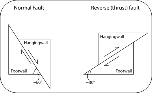
Thrust Fault:
A specific sub-category of reverse fault in which the fault plane dips at a very gentle, shallow angle.
Represents the primary structural fault style found within compressional orogenic mountain belts.
Strike-Slip Fault:
Crustal blocks slide horizontally and laterally past one another along a shear boundary.
Exhibits purely lateral translation with zero vertical motion across the fault boundary.
The fault surface is oriented vertically or nearly vertically.

Earthquake Energy Generation and Fault Rupture Dynamics
Elastic Rebound and Stress Accumulation:
Tectonic boundary forces apply differential stress (compressive, tensional, or shear) across rock masses.
In the initial stages of stress buildup, rock bends and warps without fracturing, storing strain via elastic deformation.
As stress levels continue to increase, microscopic and macroscopic fractures nucleate and expand throughout the rock body.
When the applied stress exceeds the frictional resistance and shear strength of the rock, accumulated elastic strain energy is abruptly released, forming a rupture plane or slipping along a pre-existing fault.
Fault zones represent zones of structural weakness compared to the intact host crust; over time, regional tectonic stress builds up again until it overcomes local resistance.
Stick-Slip Mechanics:
Stick Phase: Static frictional resistance along the rough asperities of the fault surface prevents contiguous blocks from moving, causing strain to accumulate elastically in adjacent rocks.
Slip Phase: The accumulated shear stress exceeds the threshold of frictional resistance, resulting in rapid, sudden fault displacement and the instantaneous propagation of seismic energy.
Frictional slip is self-limiting and cannot persist indefinitely; once stress drops sufficiently, friction re-engages and the fault locks again.
Precursory and Subsequent Shocks:
Foreshocks: Smaller-magnitude tremors that precede a main earthquake event. They stem from micro-fracturing and crack development within stressed rock bodies and may serve as an early warning of an impending large rupture.
Aftershocks: An ongoing series of earthquakes following the principal mainshock event, persisting over durations of weeks, months, or years as the crust adjusts and redistributes stress around the rupture zone.
Rupture Dimensions and Displacement:
Earthquake magnitude directly correlates with the physical surface area of the fault rupture surface.
Fault displacement is maximized at and near the hypocenter and diminishes toward the outer perimeter of the rupture patch.
Seismic Waves and Planetary Interior Propagation
Body Waves (Interior Propagation): Propagate three-dimensionally through the interior volume of the Earth.
Waves (Primary or Compressional Waves):
Particle motion is parallel to the direction of wave propagation (alternating cycles of volumetric compression and expansion).
Highest velocity of all seismic wave categories; always arrive first at recording stations.
Capable of transmitting through all physical phases of matter: solids, liquids, and gases.
Waves (Secondary or Shear Waves):
Particle motion is perpendicular (transverse) to the direction of wave propagation (moving material side-to-side and up-and-down).
Slower velocity than primary waves; arrive second at seismic recording stations.
Propagate exclusively through solid media; cannot propagate through liquids or gases due to zero shear modulus.
Surface Waves (Exterior Boundary Propagation): Propagate along the outermost free surface of the lithosphere; travel slower than body waves but produce high-amplitude ground motion responsible for intense destruction.
Waves (Rayleigh Waves): Generated when compressional waves intersect the Earth's subaerial surface; represent the fastest-traveling category of surface wave.
Waves (Love Waves): Generated when shear waves intersect the surface boundary; induce horizontal, snake-like lateral writhing of the ground surface.
Planetary Shadow Zones and Core Structure:
-Wave Shadow Zone: Because the Earth's outer core is composed of liquid iron-nickel, transverse shear waves cannot penetrate it. This creates a global shadow zone for direct waves at epicentral distances greater than from the earthquake source.
-Wave Shadow Zones: Primary waves are able to penetrate the liquid outer core, but the substantial drop in velocity at the core-mantle boundary refracts (bends) wave paths strongly inward. This seismic refraction leaves a ring-like shadow zone where direct waves are absent between epicentral angles of and .

Seismic Measurement, Travel-Time Curves, and Epicenter Triangulation
Seismic Instrumentation:
Seismometer: An instrument engineered to detect and record ground motion.
Operates using an anchored external frame and a heavy inertial mass suspended by a spring or pendulum.
During seismic shaking, the anchored frame moves with the surrounding crust while the suspended inertial mass remains stationary, allowing a pen or electronic sensor to record displacement.
Configured separately to record both vertical motion (up-and-down displacement) and horizontal motion (back-and-forth lateral displacement).
Seismogram: The written or digitized recording produced by a seismometer that displays the arrival sequence and amplitude of seismic energy over time.
Wave Arrival Progression: Because seismic velocities differ systematically, waves arrive at recording stations in an invariant sequential order:
waves arrive first.
waves arrive second.
Surface waves ( and waves) arrive last.
Travel-Time Curves and Distance Determination:
Because waves travel faster than waves, the time interval separating the arrival of the first wave and the first wave ( interval) widens progressively as distance from the earthquake source increases.
A travel-time curve graphs wave travel time in minutes against epicentral distance in kilometers.
By measuring the precise elapsed time difference between the initial -wave arrival and subsequent -wave arrival on a seismogram (for instance, a -wave arrival documented at ), geophysicists identify the unique distance corresponding to that specific lag on the travel-time curve.

Epicenter Triangulation:
A single seismometer station provides only distance to the event, defining a circle of possible locations around the station with radius .
Data from a minimum of three distinct seismic stations are required to locate the epicenter uniquely.
A geographic circle corresponding to the calculated epicentral distance is plotted around each seismic station on a map.
The single geographic point where all three circles intersect defines the true location of the earthquake epicenter.
Earthquake Size: Intensity and Magnitude Scales
Intensity vs. Magnitude:
Intensity: A subjective assessment of the degree of shaking and physical destruction inflicted on buildings, infrastructure, and the landscape at a specific location.
Magnitude: An objective, quantitative instrumental measure of the total physical energy released and maximum ground motion amplitude generated at the earthquake focus.
Mercalli Intensity Scale:
Measures the severity of structural damage and human perception of ground shaking.
Ranked using Roman numerals spanning from (barely perceptible shaking, no damage) to (complete destruction, objects thrown into the air).
Intensity values vary geographically around an event: mapped as concentric zones that attenuate in severity as distance from the epicenter increases.
Magnitude Scales:
Magnitude provides a standardized measurement calculated from maximum ground motion wave amplitudes recorded on seismometers at normalized distances.
Richter Scale: A localized magnitude scale calibrated for local, shallow-focus earthquakes situated in proximity to recording stations.
Moment Magnitude Scale (): The definitive, most accurate scientific magnitude metric. Calculated by evaluating ground motion records across multiple worldwide seismometers, measuring the physical dimensions and surface area of the fault rupture zone, and determining the average shear displacement along the fault plane.
Mathematical Scaling and Energy Equivalence:
Magnitude scales are logarithmic:
An increase of one whole magnitude integer represents a -fold increase in measured ground wave amplitude (an generates times the ground motion of an ).
An represents a -fold increase in ground motion amplitude relative to an .
Energy Calculations:
An earthquake of magnitude releases an amount of energy roughly equivalent to the detonation of the Hiroshima atomic bomb.
A unit increase of correlates to a increase in released energy.
Tectonic Settings: Plate Boundaries and Intraplate Seismicity
Transform Plate Boundaries (The San Andreas Fault System):
The San Andreas Fault cuts across the continental crust of western California.
Accommodates strike-slip shearing where the Pacific Plate slides north-northwestward relative to the North American Plate.
Highly active fault zone producing hundreds of discrete earthquakes each year.
Historical precedent: The San Francisco earthquake destroyed the city following an estimated event.
Severe hazard risk persists as major stress accumulates along locked segments of the fault.
Convergent Plate Boundaries and Subduction Zones:
Shallow Seismicity:
Extensional normal faulting occurs in the upper section of the subducting oceanic slab as it bends sharply to enter the trench.
Enormous low-angle thrust faults (megathrusts) form directly along the interfacial contact zone separating the downgoing plate from the overriding plate.
As the subducting slab drags downward, it forces the overriding plate to flex and warp; the locked overriding plate eventually snaps back elastically, generating massive megathrust earthquakes.
Intermediate and Deep Earthquakes (Wadati-Benioff Zone):
Earthquake hypocenters trace the geometry of the cold, dense oceanic lithospheric slab plunging deep into the asthenosphere.
Intermediate Depth (): The descending slab maintains cold interior temperatures, remaining sufficiently rigid and brittle to fracture mechanically.
Deep Depth (): Brittle failure ceases due to elevated ambient temperatures and pressures; seismicity at these depths is driven by high-pressure mineral phase transformations (mineral collapse into denser crystal configurations).
Earthquakes are virtually nonexistent at depths exceeding because the mantle behaves plastically without generating shear fractures.
Intraplate Earthquakes:
Approximately of all earthquakes occur within the stable interior of tectonic plates, far away from active plate margins.
Triggered by the localized reactivation of ancient zones of structural weakness, failed paleorifts, or buried ancestral plate margins under modern intraplate compressive stresses.
New Madrid Seismic Zone: Located within the central United States in Missouri. In , a series of three massive earthquakes with approximate magnitudes of struck the region, likely caused by slip along an ancient, deeply buried continental rift zone.
Earthquake Damage, Geological Hazards, and Tsunamis
Determinants of Shaking and Damage Severity:
The total magnitude and seismic energy released by the earthquake.
The proximity and physical distance of surface structures from the hypocenter/focus.
The physical composition and mechanical properties of the underlying geological substratum:
Solid Bedrock: Transmits high-frequency seismic body waves rapidly with minimal wave amplification, leading to substantially less surface shaking and structural damage.
Unconsolidated Sediments and Artificial Fill: Waves decelerate upon entering soft material, causing energy to reflect and refract, which dramatically amplifies wave amplitudes and prolongs shaking duration, leading to catastrophic destruction.
Secondary Geological Hazards:
Landslides and Avalanches: Ground acceleration destabilizes poorly consolidated slopes and steep cliffs in upland regions, triggering widespread mass wasting.
Liquefaction: Cyclic shear stress from seismic waves pressurizes pore fluids within water-saturated, cohesionless granular sediments (sands and silts).
Pore water pressure rises until it matches overburden pressure, causing sediments to lose all internal shear strength and behave as a viscous fluid.
Underlying structural foundations slump, rotate, sink, or collapse.
Cohesionless saturated sand transitions into quicksand; sensitive water-rich clays convert into quickclay.
Fire:
A major post-earthquake agent of destruction that frequently causes greater loss of life and property than direct ground shaking.
Vigorous ground motion overturns indoor heating stoves, topples lit candles, downs electrical transmission lines, and ruptures municipal natural gas mains and chemical fuel storage tanks.
Fires spread uncontrollably because critical municipal infrastructure—such as water mains, roads, power grids, and communication systems—is shattered, leaving firefighting teams without water pressure or access routes.
Tsunamis (Harbor Waves):
Origins: Large-scale marine waves generated by sudden, vertical displacement of the oceanic floor.
Primary mechanisms include megathrust faulting, massive submarine landslides, or explosive volcanic caldera collapse.
Vertical seabed deformation displaces the entire overlying oceanic water column simultaneously.
Frequency and Hazard Profile:
Destructive tsunamis occur globally at an average rate of roughly one event per year.
More than destructive tsunami events have occurred across the past century.
Rising human demographic density along low-lying coastal plains significantly increases vulnerability to future events.
Contrasting Wind Waves and Tsunami Waves:
Wind Waves:
Disturb only the surface layer of the ocean, with particle motion attenuating to zero below an approximate water depth of .
Wavelengths span modest distances of several tens to several hundreds of meters.
Wave height, period, and wavelength are directly proportional to atmospheric wind speed and duration.
Phase velocities reach maximum speeds of several tens of kilometers per hour.
Waves steepen, break in the nearshore surf zone, and expend their kinetic energy across a narrow shoreline strip.
Tsunami Waves:
Disturb the entire vertical water column, from the sea surface down to the abyssal ocean floor.
Enormous wavelengths spanning from several kilometers to hundreds of kilometers.
Dimensions and energy are entirely independent of local atmospheric wind conditions.
Open-ocean propagation velocities reach several hundred kilometers per hour (comparable to commercial jet aircraft speeds).
Upon entering shallow coastal environments, the wave base encounters friction, compressing wavelength and dramatically increasing wave height.
Tsunamis do not break as normal surf; instead, they strike the coast as a rapidly advancing, elevated plateau of water that surges inland over extensive distances with minimal energy dissipation.