(NOT FINISHED 4.3) Unit 4: Earth Systems and Resources
(4.1) Plate Tectonics
PLATES + BOUNDARIES
Earth’s layers:
Lithosphere (crust)
Asthenosphere (upper mantle)
Oceans and land sit on top of layer
Mesosphere (lower mantle)
Convergent plate boundary: plates that push towards each other
Causes volcanoes, rising magma, and earthquakes, trenches, island arcs
Divergent plate boundary: plates that push away from each other
Has ridges/volcanoes
Causes seafloor spreading, hotspots
Less frequent earthquakes
Transform plate boundary (aka Strike-Slip): plates that push past each other in opposite directions
No ridges/volcanoes
Shallow/frequent earthquakes
Causes fault lines
Continental plates: plates that carry continents, earth, and rock
Less dense → float
Plates might have several boundaries with other plates → diverse geological features
Can have breaks in surfaces → volcanic island change
EX: Japan, Indonesia, Hawaii
GEOLOGICAL FEATURES
Convection: movement of Earth’s tectonic plates that are driven by currents in the mantle layer
Earthquakes: movement in the Earth caused on fault lines/plate boundaries
Occur at transform boundaries
Fault lines lock up/press to each other → builds up stress → energy releases
Tsunamis: long sea wave that gets bigger as it reaches the coastline
Earthquakes, underwater landslides → tsunamis
Destroys habitats, drowns species, uproots trees, contaminates freshwater (w/ saltwater + debris)
Subduction Zone: one plate gets pressed under another plate that rises above it
Occur at convergent boundaries
(4.2) Soil Formation + Erosion
SOIL
Parent material is weathered → transported → deposited → soil
Factors:
Type of parent material (soil contains the chemistry of the rock)
Climate (average temperature, moisture change of weathering, the nutrients in the moisture, and wind)
Topography (slope of land)
Biological factors (plants, animals, microorganisms)
Time (how long soil forms)
Parent material: original rocks that are broken down to form the base of soil
Done by Weathering: breakdown of rock
Soil profile (or Soil Horizons): layers of soil built up over time
O-horizon: organic matter
Contains organisms, leaf litter,
A-horizon: surface soil
Contains humus, organic material, some rock
B-horizon: subsoil
Surface soil but with more rock
C-horizon: substrata
Parent material
(R-horizon) = bedrock
EROSION
Soil erosion: topsoil is stripped away by wind, water, gravity
Human factors:
Deforestation (lack of roots that hold down the soil → replaced by plants that worsen erosion like wheat or soybean)
Overgrazing (cattle overeating → exposes topsoil)
Pesticides/fertilizers (changes chemistry of soil + kills microorganisms in soil)
Tilling (breaking soil prevents topsoil from getting organic material/roots)
Sheet erosion: surface layer is removed by water
Solution: maintain plant coverage
Rill erosion: small channels of water flow soil away
Solution: strip cropping/contouring tilling (low tilling)
Gully erosion: wider cuts in soil from expanded rill erosion
Solution: divert water away from rills or solve rill erosion
(4.3) NOT FINISHED
(4.4) Earth’s Atmosphere
(4.4) Earth’s Atmosphere(4.4) Earth’s AtmosphereAtmosphere contains:
Nitrogen (78%)
Oxygen (21%)
Trace Gases (1%)
Argon → Carbon dioxyde → Neon → Helium → CH4 → Krypton → Hydrogen → Water
Atmosphere layers
Exosphere (600-10,000 km)
enters space → drop in temperature
Thermosphere (85-600 km)
x-ray radiation + UV rays → rise in temperature
air’s still thin
Mesosphere (50-85 km)
thinning atmosphere → drop in temperature
Stratosphere (20-50 km)
radiation → rise in temperature
Troposphere (0 to 6-20 km)
varies depending on location
densest layer
contains weather
(4.5) Global Wind Patterns
Earth’s rotation → air circulates → predictability of wind patterns
Causes different ecosystems
EX: Tropical climates near the equator
Convection: cycle caused by earth’s rotation
as air expands, gets less dense and moves up to the poles → air heats,
as air compacts, gets denser and returns down → air cools down
repeats
exemplified in a Hadley Cell
Coriolis Effect: Earth deflecting winds as it rotates
Hot air from equator deflects → colder air
(4.6) Watersheds
Watershed: area of land that drains water into a central body of water
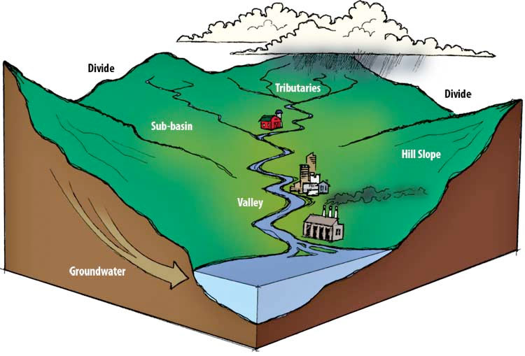
Highest point/divide: highest point of watershed
Tributary: where water runs down from highest point
Transition zone
River: more water comes down
Transition zone
Delta: rivers join and water falls into basin (aquifer)
Groundwater/aquifer: the basin which has the runoff
Characteristics of watersheds:
Area
Vegetation
More vegetation = water is absorbed in the soil → groundwater
Type of soil
Permeable soil = water in groundwater
Impermeable soil = runoff
Slope
Steeper = runoff than absorb into the ground
Human activity that affect watershed
Logging (removal of trees → sediment of soil runs in water)
Industrial sites (pollution → rivers)
Residential areas (waste, usage → quality or amount of water)
Cities (water runs off of streets)
Livestock/cropland (fertilizers + pesticides → quality of water)
Dams (blocks sediments that goes into natural habitats)
(4.7) Solar Radiation + Earth’s Seasons
Insolation: how much solar radiation areas of Earth recieves
Equator gets more concentrated insolation, poles get less (sun reaches farhter)
Solar radiation can get scattered over atmosphere
Seasons happen because of Earth’s tilt, NOT Earth’s faces
Affects equinoxes, solstices, poles’ hottest/coldest days,
EX: tropic of crapicorn = most solar radition during December, tropic of cancer = most solar radiation in June
(4.8) Earth’s Geography + Climate
Air moves over water → water evaporates → air heats up
Air continues to land → water condenses → cools down → falls (snow, rain, etc)
As it continues, air is less dense and gets slightly warmer
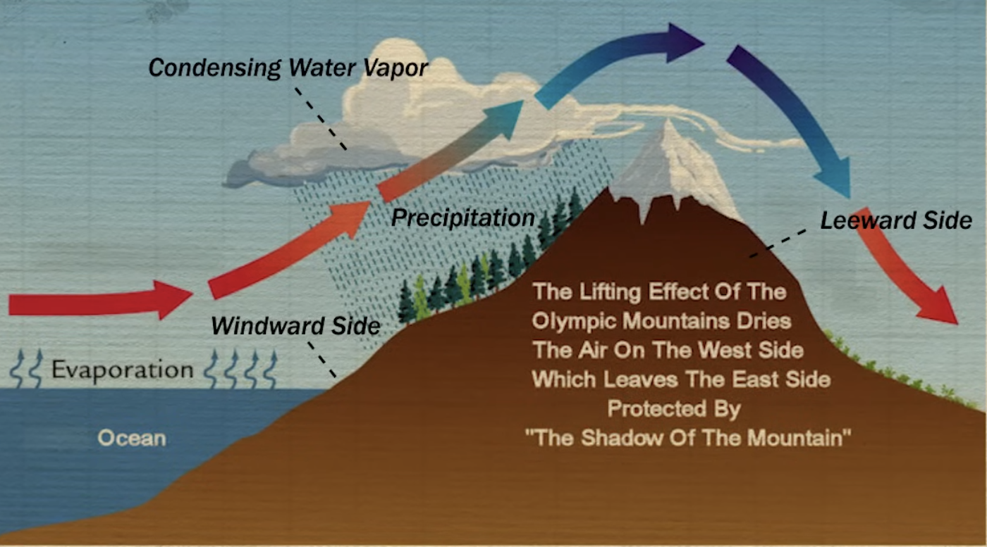
Rain-shadow effect: how air moisture changes as air comes from the sea → mountain → land
Water evaporates with air over ocean → rises up the mountain on windward side (precipitation through rain) → condenses + cools down → less dense as it drops in leeward side
Windward side: side of a mountain facing coastline
Leeward side: side of a mountain facing inland
Arid climate because of effect
(4.9) La Niña + El Niño
ENSO (El Niño Southern Oscillation): drastic extremes between El Nino, La Nina, and normal ocean circulation petterns
El Niño = hot, La Niña = cold
Takes place in equator
Normal circulations
Trade winds bring warm temperatures from east to west
Brings more wind and rainfall to Australian + Southeast Asia region
Upwelling (cold, nutrient + oxygen rich water moves to the surface to replace warm waters blown away) in the Americas
Thermocline tilts from east to west (rises in east, lowers in west)
El Niño
Flips wind patterns
No upwellign and warmer water in Americas
Colder, drought conditions in Australia region
Flooding since region isn’t used to that much water
Thermocline levels
La Niña
Extreme version of normal circulations, strong trade winds
Flash flooding in Australia region
Drier climate in Americas
More upwelling in Americas → more nutrient + oxygen rich water
Thermocline is steep