chapter 4: ocean basins (ocean basins)
the ocean floor is mapped by bathymetry
previously people measured bathymetry using rope and a stone tied to it, by lowering the stone down into the water and waiting till it hit the bottom. after that people moved on to echosounding, where sound is bounced off of the seafloor and reflected back onto the ships computer. then people started using satellites to measure the dips and rises in the ocean surface to map out seabed topography
echosounders use 121 beams radiating from the ships hul, which are fanned out at right angles to the direction of travel. a ping is sent every 10 seconds toward the seabed and the refleected sound is recorded from narrow corridors
satellites measure divots and rises on the ocean surface to measure the topography of the seafloor. there is usally distrotion of the sea surface above the seabed when extra gravitational attraction of the feature pulls water toward it from the sides, forming a mound of water over itself.
ocean floor topography varies with location
the submerged outer edge of the continent is called the continental margin
the deep sea floor beyond the continental margin is properly called the ocean basin
the ocean basin would have the dip from the continental shelf tot eh rest of the sea bed. but in between the shelf and the floor there are sea mounts, ridges, canyons, and other strucutres, making it just a simple bowl strucutre, but more like how terrestrial topography is, but underwater
it is the continental margin and the ocean basin. the contitnetal margin is the outer edge of the continent and the ocean basin id teh deep sea floor beyond teh continental margin
seabed topography results from plate movement and isostatic balance
continental margins may be active or passive
passive margins
form where the plates are moving apart (diverging boundaries)
characterised by broad continental shelves, thick sediments, and gentle slopes
little tectonic activity
common around the atlantic ocean
features:
broad, gently sloping shelf extends far from shore
extends from shore ina gentle angle
350 km in width and end at a depth of about 140m, where steeper drop-off begins
active margins
forms where plates collide (converging) or slide past one another (trasnfroms boundaries)
narrow shelves, steep slopes, deep ocean trenches often present high tectonic activity
common around teh pacific ocean (pacific ring of fire)
the topography of deep ocean basins
continental slopes connect the continnetal shleves to the deep ocean floor
continental slopes are formed by sediment accumulating at hte helf edge
sediments are trasnported dwonslope to the ocean floor
contintnetal rises form as sediments accumulate at the base of the continental slope
these sediments are transported by turbidity currents
earthquakes can trigger underwater landslides or sediment flows called turbidity currents
the sediments on the deep ocean floor reflect the history of the surrounding continents, the biological productivity, and the ages of the basins
ridges occur along divergent plate boundaries, where new ocean floor is created as teh earths tectonic plates spread apart
spreading rate of the plates control topography
as the plates separate, molten rocks rises to teh seafloor producing enormous volcanic eruptions of basalt
spreading speed shapes the ridge
slow spreading → steep rugged terrain
fast spreading → wide gentle slopes
hydrothermal vents are hot springs on active oceanic ridges
abyssal plains (and abyssal hills) cover most of earth’s surface
abyssal plains are flat featureless expanses of sediment covering the ocean floor
they lie between the contitnetla margins and the oceanic ridges
seamounts and oceanic trenches
seamounts → volcanic projections that do not rise above the surface of the sea
trench → an arc-shaped depression in the deep ocean floor. They occur where a converging ocenaic plate is subducted
trenches and trash
human impacts in the trench
platic bag
snailfish and drifiting into the mariana trench carry mercury pollution with them which has led to mercury pollution in this area which was thought to be pristine becuase of this depth
how would scinetists explore the deep and detect human impacts
sunmersibles and ROVs
major features of ocean basins
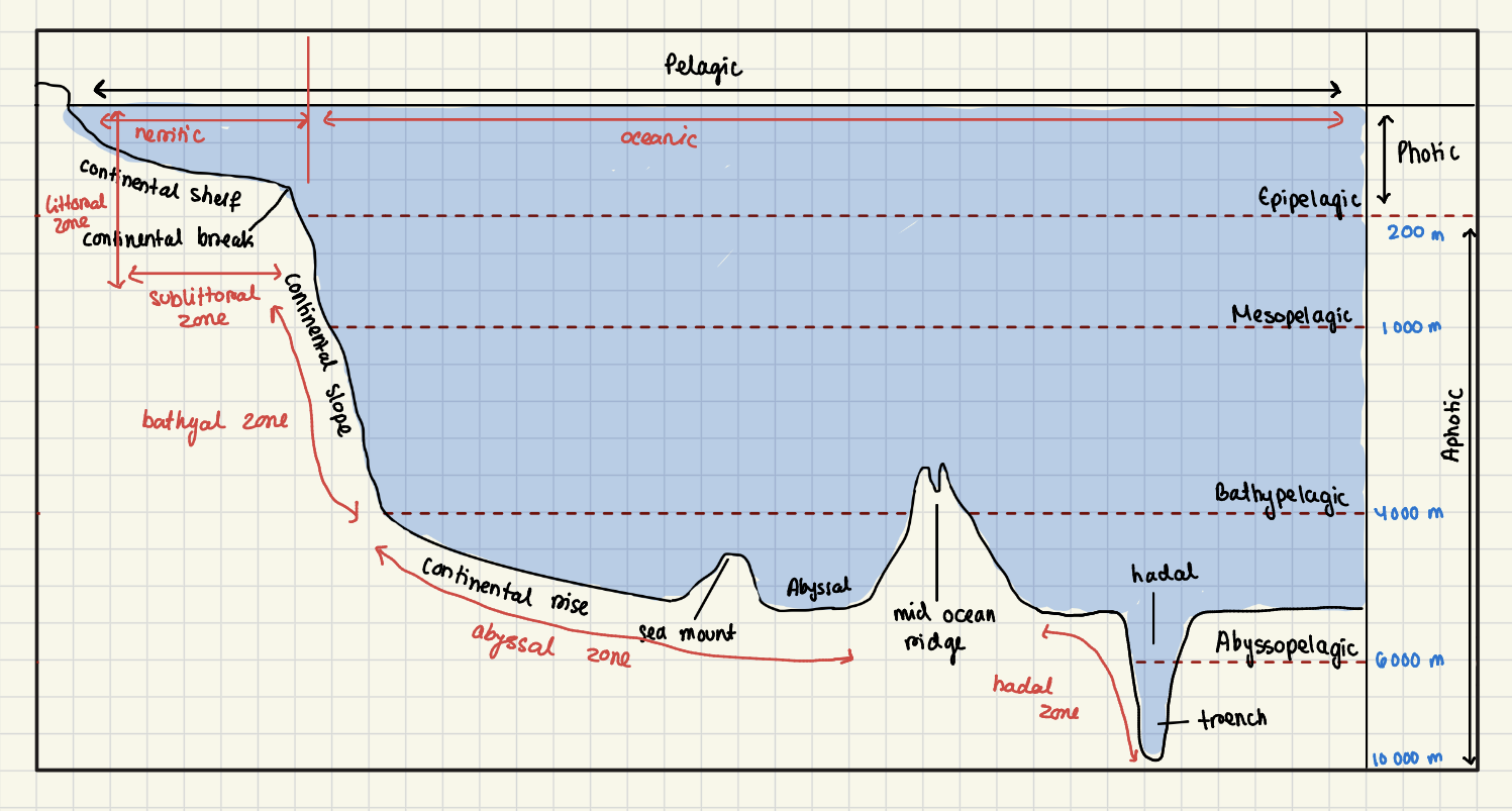
neritic zone: shallow water just above the continental shelf
oceanic zone: deep water beyond the shelf
epipelagic → sunlit surface layer
mesopelagic
bathypelagic
abyssopelagic
two major differences between neritic and oceanic zones that affects biota
nutrients are high in the neritic zone, coming in from river inputs, upwelling, and resuspension of seidments. in the oceanic zone there are lower amounts of nutrients because its farther from land + stronger stratification. the neritic zone has high primary production; ocenaic zone has low surface production
light is absorbed more quickly in neritic waters because of higher particle loads and turbidity. there is less blue light penetration, and a shallower photic zone. in oceanic waters, its more clear, so blue light penetrates the deepest. this leads toa deeper photic zone, affecting photosynthetic organisms and visual predators