Paleozoic Era Overview
PALEOZOIC OVERVIEW
The Paleozoic Era(고생대), spanning(기간,범위에 걸쳐 있는, 이어지는) from approximately to million years ago (Ma), saw profound changes in the Earth's continents, oceans, and life forms.
A. Main “Themes”
Collision of Geologic “Terranes(지괴)” - Repeated collisions of landmasses(대륙) created three Palezoic versions of the Appalachian.
Foreland Basin Development in Eastern North America. - Three foreland basins formed in eastern North America with each successive orogeny.
Clastic wedge(쇄설 쐐기층): A thick(thousands of meters), aerially(공중에서, 대기 중에서,) extensive(넓은,광범위한) , fan-shaped deposit that washed off growing mountains into the foreland basin. it is what fills up the foreland basin. - 성장하는 산맥에서 전지대 분지로 씻겨 내려온 퇴적물이 쌓여 형성된 두꺼운 그리고 넓게 퍼진 부채꼴 모양의 퇴적체를 말한다. 즉, 쇄설 쐐기층은 전지대 분지를 채우는 주요 퇴적물.
Major events depicted in FIGURE 10-1 include the
fragmentation of supercontinents(초대륙의 분열),
significant sea-level fluctuations(큰 해수면 변화) (transgressions(해진) and regressions(해퇴))
major periods of mountain building (orogenies) 산맥 형성기(orogeny)로 불리는 주요 조산 운동
widespread marine invertebrate radiation 광범위한 해양 무척추 동물의 방산
The colonization of land by plants and animals 식물과 동물의 육상 진출
major mass extinction events 대규모 멸종 사건
fragmentation:분열, 파편화,붕괴
significant: 중요한,상당한(큰,현저한)
invertebrate(무척추동물): 이 시기에 가장 두드러진 생물군으로, 해양 생태계에서 매우 중요한 역할을 했습니다.
colonization:식민지화,정착,(생물의) 서식 확장
extinction: 멸종,소멸,절멸
landmass(육괴): 넓은 땅덩어리나 대륙 규모의 지표 영역
EARLY PALEOZOIC CONTINENTS(대륙들)
During the early Paleozoic, the Earth's landmasses were configured(구성된,배열된,형성된) differently than today, impacting ocean circulation(순환,유통,흐름), climate, and the distribution(분포) of life. The main early Paleozoic continents included:
Laurentia(로렌시아): A vast continental block comprising proto-North America, Greenland, and parts of the British Isles (Ireland and Scotland). It was largely positioned in equatorial regions.
Baltica(발티카): Consisting of Northern Europe and western Russia, it was separated from Laurentia by the Iapetus Ocean.
Siberia(시베리아): A distinct continental mass corresponding(헤당하는,일치하는,관련된) to modern Russia east of the Ural Mountains and north of Mongolia.
China: A complex of smaller blocks including modern China, Indochina, and the Malay Peninsula, eventually amalgamating(합쳐지는,통합되는) later in the Paleozoic.
Gondwana(곤드와나): The supercontinent of the Southern Hemisphere, encompassing Africa, South America, India, Australia, and Antarctica. It was a massive landmass that would later drift apart.
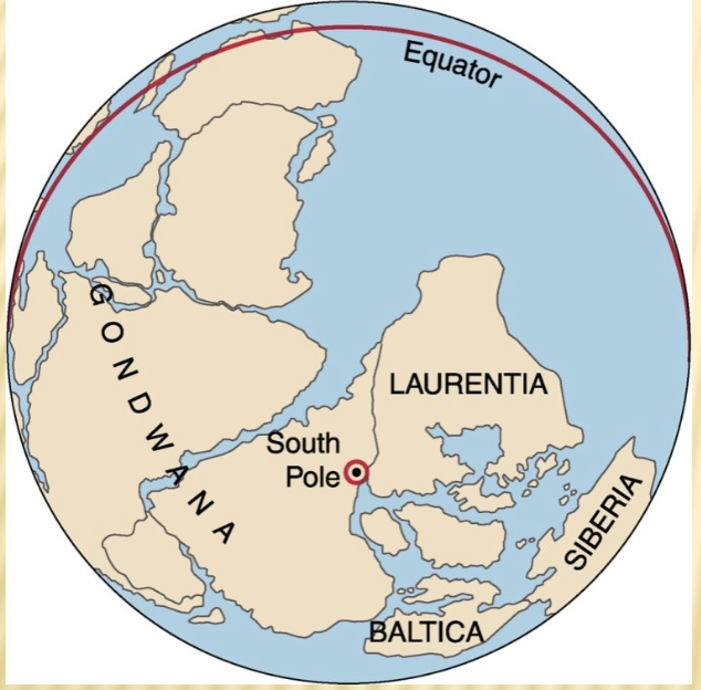
FIGURE 10-2 illustrates the arrangement of these landmasses during the preceding(이전의,앞선) Neoproterozoic Era(신원생대), setting the stage for Paleozoic(고생대) continental drift. - 이전의 신원생대 동안 육괴 들이 어떻게 배열되어 있는지를 보여주며, 이는 고생대(paleozoic era)의 대륙 이동(continental drift)을 위한 기반을 형성한 시기를 나타냄.
CAMBRIAN PALEOGEOGRAPHY(캄브리아기 고대 지리)
Laurentia Coverage(로렌시아의 영역):
During the Cambrian Period ( to Ma), Laurentia was almost entirely covered by shallow epicontinental(대륙 내부의) seas, marking a major marine transgression known as the Sauk transgression. These seas were relatively warm and clear. - 이 시기의 바다는 상대적으로 따듯하고 맑은 환경.
Its position near the equator(적도) resulted in warmer water temperatures, ideal for the proliferation(급증,확산) of marine life and carbonate deposition.
The shallow marine environments facilitated(촉진했다,쉽게 만들었다) the deposition of vast quartz sand (from eroding landmasses) and carbonate sediments (from marine organisms like archaeocyathids(고세균해면) and trilobites(삼엽충)). In deeper water settings closer to the continental edges(대륙 주변부) and in basins(분지), quieter conditions(조용한 환경) led to(~로 이어졌다) the accumulation of fine-grained muds, which eventually formed shale deposits. - 더 조용한 환경에서는 미세한 진흙이 쌓이게 되었고, 이것이 결국 셰일(Shale) 퇴적층을 형성하였다.
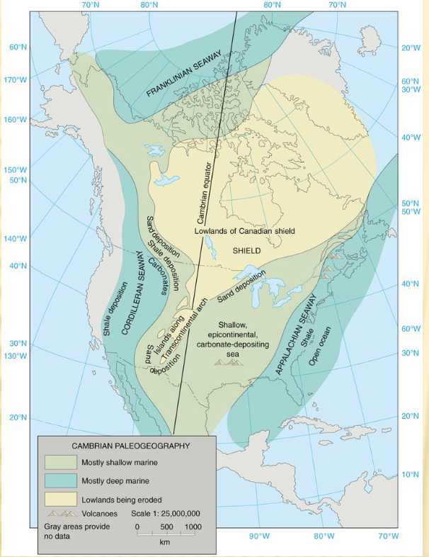
Illustrated in FIGURE 10-4, which provides a reconstructed paleogeographic(고대 지리의) map of North America during the Cambrian Period, highlighting the extent of these shallow seas. 캄브리아기 동안 북아메리카의 재구성된 고지리학적 지도로, 이러한 얕은 바다가 얼마나 넓게 퍼졌 있었는지를 보여준다.
Epicontinental sea: 대륙의 가장자리나 내부에 위치한 얕은 바다
Equator(적도): 지구를 북반구와 남반구로 나누는 가상의 원. 이 지역은 햇빛이 가장 강하게 닿는 곳 연중 기온 높음.
Basin: 지표면이 움푹 들어가서 퇴적물이 쌓이는 낮은 지형이나 구조적인 지역
PALEOZOIC ROCKS OF THE PLATFORM
Paleozoic strata(고생대 지층들) across the stable continental interior (the cratonic platform) are generally flat-lying or gently dipping, indicating a long period of crustal(지각의) stability away from active plate margins. -활발한 판 경계로부터 멀리 떨어진 지역에서 오랜 기간 동안 지각이 안정적 이었다는 것을 나타냄.
These strata are often deformed(변형된다) into broad(넓은,광범위한) gentle structures such as basins (downwarped areas where sediments accumulated), domes (upwarped areas), arches (elongated(길게 뻗은) domes), and broad synclines (trough-like folds). These structures are typically the result of gentle epeirogenic movements over vast periods rather than intense orogenic compression. - 오랜 기간에 걸친 완만한 대지조 운동 결과로 형성 된것.
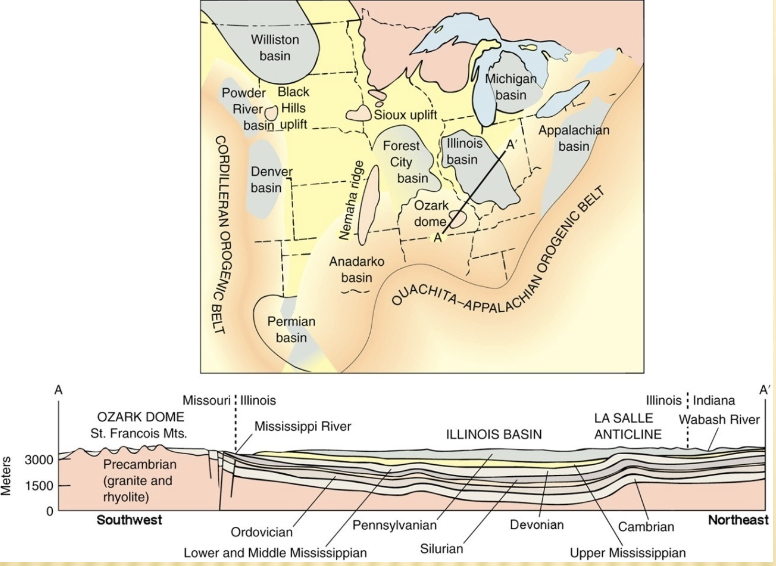
The central platform of the United States, as depicted in FIGURE 10-5, clearly indicates areas of major basins and domes, which are important traps for oil, gas, and groundwater.
stable continental interior = cratonic platform
craton(크라톤): 오래되고 안정된 대륙의 핵심 부분
shield(순상지): 크라톤 중 암석이 드러난 지역
platform(플랫폼): 순상지를 덮는 퇴적층이 있는 부분
epeirogenic movements(대지조 운동): 지각이 넓은 지역에서 아주 서서히 올라가거나 내려가는 운동. - 대륙 전체가 천천히 들리거나 가라앉는 아주 완만한 운동.
OROGENIES(조산운동,산맥 형성 작용)
In the Appalachian mobile belt(애팔래치아 이동대), a series of significant(중요한,중대한,상대한) mountain-building events, or orogenies, occurred as part of the closure(닫힘,폐쇄,마감) of the Iapetus Ocean(이아페투스 해) and subsequent(그 후의,뒤이은,이후의) continental collisions:
Taconic orogeny: This early Paleozoic orogeny (Ordovician) resulted from the collision of an island arc with the eastern margin of Laurentia. It produced the first major mountains in the Appalachian region and is known for producing vast clastic wedges of sediment (flysch and molasse). -오르도비스기 에 일어난 조산운동은 섬호가 로렌시아 대륙의 동쪽 가장자리와 충돌한 결과로 발생. 이 운동은 애팔래치아 지역에서 최초의 주요 산맥을 형성, 광범위한 쇄설성 퇴적물층 즉 flysch and molasse을 만들어냄.
Which orogeny involved the collision of island arcs with laurentia, producing the first major mountains in the Appalachian region? - Taconic orogeny
Taconic orogeny = Ordovician Period
Acadian orogeny(이카디아 산맥형성 작용): Occurring during the Devonian Period, this orogeny involved the collision of the microcontinent(소대륙) Avalon (or Carolina terrane) with eastern Laurentia, following the final closure of the Iapetus Ocean. It reactivated and further uplifted the Appalachian chain, leading to extensive(광범위한,넓은,대규모의) igneous activity and metamorphism.
Acadian orogeny = Devonian Period
Alleghanian orogeny: This late Paleozoic orogeny (Carboniferous-Permian) was the final and
most powerful phase(단계,시기,시점) of Appalachian mountain building, resulting from the collision of Gondwana (specifically, the African part) with Laurentia. This event completed the formation of the supercontinent Pangea and created the modern Appalachian Mountains. 후기 고생대의 산맥 형성 작용 석탄기에서 페름기 동안 일어남. 애팔래치아 산맥 형성의 마지막이자 가장 강력한 단계.
Alleghanian orogeny = late Paleozoic orogeny
Alleghanian orogeny 사건은 초대륙 판게아의 형성을 완성시킴,
lapetus Ocean(이아페투스 해양): 약 6억년전~4억년전 존재했던 고대해양 이 바다는 laurentia,baltacia,gondwana등의 고대 대륙 사이에 있었음.
Orogeny(산맥 형성 작용): 지각의 강한 압축력으로 인해 산맥이 형성되는 과정. 즉, 판과 판이 충돌하거나 밀려서 지각이 접히고 융기되어 산맥이 만들어지는 사건.
Appalachian mobile belt(애팔래치아 이동대): 북아메리카 대륙의 동쪽 가장자리에 위치한, 지각이 과거에 강하게 변형되고 산맥이 형성된 지역.
Island arc(섬호): 해양판이 섭입하면서 만들어지는 화산 섬들이 활 모양 형태로 이어진 지형.
Supercontinent Pangea(초대륙 판게아): 3억년전(석탄기~페름기에) 지구의 거의 모든 대륙이 하나로 합쳐져 형성된 초대륙. - 지구의 모든 대륙이 하나로 이어진 거대한 대륙.
UNCONFORMITIES(불정합)
During periods of marine regression(해수면이 하강했던 해퇴기 동안), when sea levels fell, large areas of former(이전의,과거의) seafloor were exposed to subaerial erosion(지표 침식). This erosion stripped away(제거) vast quantities of previously deposited sediment, resulting in extensive unconformities. 바닷물이 빠져나가서(해수면이 낮아져서) 예전에는 바다 밑이었던 지역이 땅위로 드러나자 비,바람 등의 침식 작용(지표 침식)이 일어났으며 이 결과로, 이전에 쌓였던 퇴적물들이 깎여 나가지면서 지층이 끊긴 흔적(unconformity:불정합)이 생겼다.
These unconformities represent significant gaps in the geological record and serve as key stratigraphic boundaries, defining the limits between major transgressive-regressive sequences (often referred to as Sloss sequences) that characterized the Paleozoic craton.
Transgressive-Regressive sequences = Sloss Sequence
Unconformitiy(불정합): 서로 다른 시기에 퇴적된 암층(지층) 사이에 존재하는 시간적 공백(geologic gap) 또는 침식면(erosional surface)이다. - 퇴적이 잠시 멈추거나 침식이 일어난 후, 다시 퇴적이 시작되어 지층의 연속성이 끊긴 부분.
Subaerial erosion(지표 침식): 물, 바람,빙하, 증력 등 대기 영향을 받는 자연 작용에 의해 노출된 지표면이 깎여 나가는 과정
Transgression(해진): 바닷물이 육지 쪽으로 들어오는것(해수면 상승)
Regression(해퇴): 바닷물이 육지에서 물러나는 것(해수면 하강)
palezoic craton(고생대의 크라톤): 고생대 시기 동안 지각 변동이 거의 없었던 대륙 중심부의 안정된 지역
CRATONIC SEQUENCES(크라톤 서열)
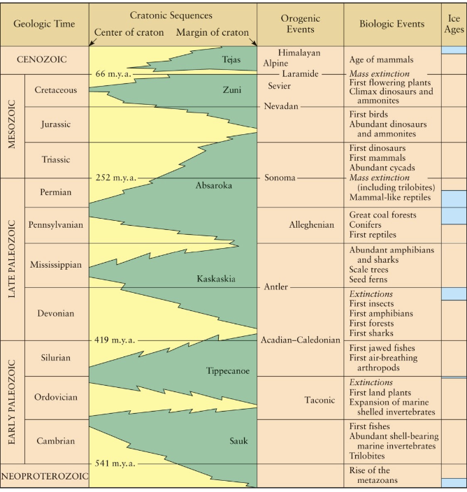
North American cratonic sequences are typically illustrated to show the cyclical(주기적인, 순환적인,반복적인) nature of marine transgressions and regressions across the continental interior.
Green areas on these diagrams generally represent the preserved sedimentary deposits laid down during periods of marine transgression (when sea levels were high and the continent was submerged).
Yellow areas indicate missing strata, which are associated with the erosional surfaces of unconformities that formed during periods of marine regression (when sea levels fell, exposing the land to erosion).
These sequences (Sauk, Tippecanoe, Kaskaskia, Absaroka) record the episodic flooding and exposure of the North American craton.
Cratonic sequences(크라톤 퇴적 서열): 대륙의 안정된 내부 지역(=craton)에서 해수면 상승(transgression,rises)과 하강(regression,falls)이 반복되며 쌓인 대규모 퇴적암 층서(sequence of sedimentary rocks)를 말한다.
Transgression(해수면 상승): 육상에서 얕은 바다로(퇴적암 순서: sandstone - shale - limestone)
Regression(해수면 하강): 해양에서 육상으로(퇴적암 순서: limestone - shale - samdstone)
CAMBRIAN DEPOSITS OF THE GRAND CANYON REGION
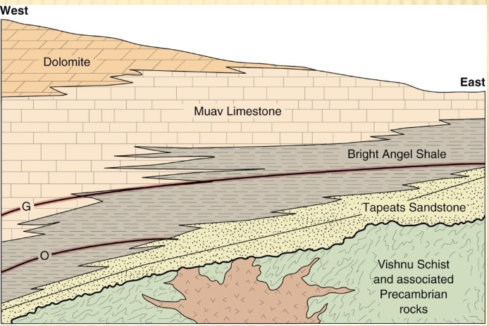
The classic geological cross-section of the Grand Canyon beautifully illustrates Cambrian depositional patterns. The Lower Cambrian Tapeats Sandstone, a key unit in the Tonto Group, serves as an excellent example of sandy beach and shallow shelf deposits.
그랜드 캐니언의 고전적인 지질 단면도는 캄브리아기의 퇴적 양상을 아름답게 보여준다. 하부 캄브리아기의 태피츠 사암층은 톤토 지층군의 핵심 단위로, 모래 해변과 얕은 대륙붕 환경에서 형성된 퇴적물의 대표적인 예
It lies unconformably (the Great Unconformity) over much older Precambrian metamorphic and igneous rocks, representing a vast gap in geological time. The Tapeats Sandstone gradually(점차적으로,서서히) grades upward into the Bright Angel Shale (representing deeper prodelta and offshore marine muds), which then transitions into the Muav Limestone (representing clear, warm, open-marine conditions), completing a transgressive sequence. - Tapeats Sandstone은 점차적으로 위쪽으로 밝은 엔젤 셰일로 이어지는데 이는 더 깊은 전삼각주와 외해의 해양 진흙환경을 나타냄. 그 위로는 Muav Limestone으로 전이되며 이는 맑고 따뜻한 개방 해양 환경(clear,warm,open-marine conditions)을 보여준다. 이러한 변화는 하나의 해진 서열(Transgressive sequence,바다가 점차 육지쪽으로 진입한 퇴적 주기)을 완성.
그랜드 캐니언의 Tapeats Sandstone은 과거 모래해변과 얕은 바다에서 쌓인 퇴적물의 대표적인 예
prodelta(삼각주 전면부): 하천이 바다로 흘러 들어가는 삼각주(delta)의 가장 깊은 바다 쪽 부분
offshore(외해):깊은 수심, 파도 영향 적음, 진흙 퇴적 많음
onshore(해안쪽/육지쪽): 육지나 해변 근처
ORDOVICIAN PALEOGEOGRAPHY(오르도비스기 고대 지리)
During the Ordovician Period ( to Ma), significant tectonic activity(지각 운동) began to impact eastern North America. Mountains and volcanic island arcs began to form in the Appalachian region due to the initial stages of the Taconic Orogeny(타고닉 산맥 형성 작용), marking the closure(닫힘,폐쇠,종결) of the Iapetus Ocean(이아페투스 해). 이아페투스 해가 닫히기 시작하는 초기 단계에서 일어난 타코닉 산맥 형성 작용으로 인해 Appalachin region에는 산맥과 화산섬호가 형성되기 시작.
Evidence for this includes the widespread presence(존재,출현) of volcanic ash deposits found within Ordovician rocks in the eastern U.S. These ash layers have been altered(변형된,변질된,변화된) over time into a distinctive(뚜렷한,특징적인,독특한) clay known as bentonite, which is an important stratigraphic marker due to its widespread distribution and relatively instantaneous(순간적인,즉각적인) deposition. - 화산재층은 시간이 지나면서 변화하여 bentonite라고 불리는 특징적인 점토로 변질됨.
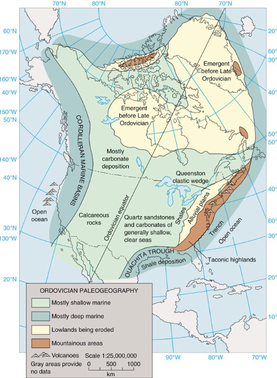
FIGURE 10-27 provides a paleogeographic reconstruction of Ordovician North America, showing the developing mountains to the east and the expansive shallow seas covering much of the craton.
HISTORY OF A FORELAND BASIN
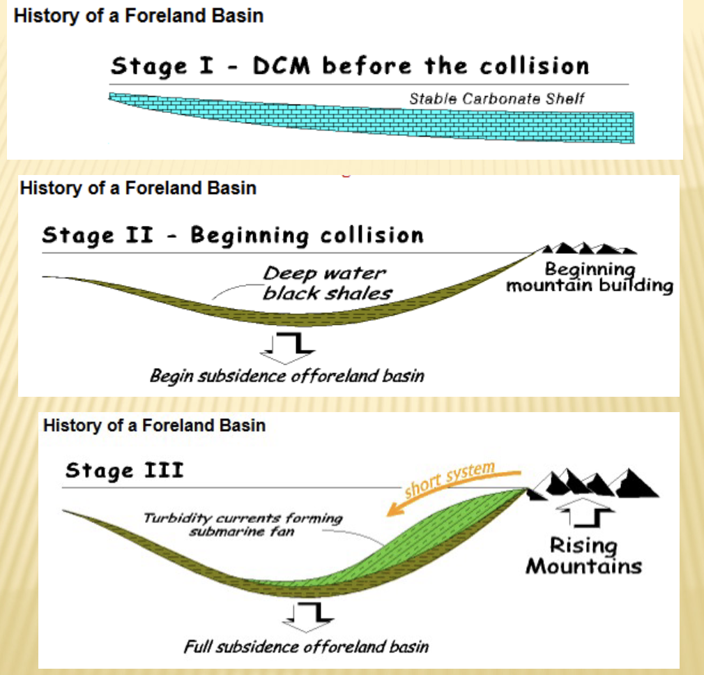
The development of a foreland basin, common during orogenic events, unfolds in several stages as a result of crustal loading from mountain building:
Stage I: Before collision, the continental margin(가장자리,지각 경계) (e.g., Nevada's carbonate shelf) is a passive(수동적인,비활성적인) margin, characterized by stable, clear, shallow-water carbonate deposition. - Stable carbonate shelf(안정된 탄산염 대륙붕: 지각 활동이 거의 없는 얕고 안정된 바다 환경에서 형성된 탄산염 퇴적 지역, 주로 limestone이 형성되는 환경.
Stage II: Initiating collision(충돌이 시작될때) (e.g., approach of an island arc or continent) causes crustal flexure(지각의 굴곡), creating a foreland basin. Subsidence in this basin leads to deeper water conditions and the deposition of deep-water black shales, often anoxic(무산소) due to restricted(제한된,좁은,제한적인) circulation. 지각의 굴곡이 일어나면 전지대 분지가 형성. 그 결과 깊은 바다에서 퇴적된 흑색 셰일이 쌓이게 된다. 흑색 셰일은 순한이 제한되어 산소가 부족한 무산소 환경에서 형성 되는 경우 많음.
Stage III: As the mountain belt rises, erosion provides massive amounts of sediment. Turbidity currents(탁류), triggered(유발된,촉발된) by submarine landslides or storm events, begin to transport these sediments rapidly into the foreland basin, forming submarine fans.
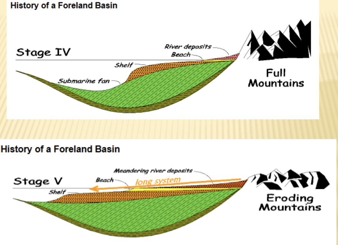
Stage IV: Continued uplift(들림,지각의 상승) and erosion of the mountain belt lead to extensive sediment accumulation within the foreland basin, building out large submarine fans composed of turbidites (alternating layers of sandstone and shale). - 산맥대의 지속적인 들림과 침식이 계속되면서 전지대 분지 내부에 광범위한 퇴적물 축적이 일어난다. 이 퇴적물들은 turbiditeds, 즉 사암과 셰일이 번갈아 나타나는 층상 퇴적물로 구성된 submarine fanse을 형성
Stage V: As the mountain building progresses and the basin fills, the depositional environment shallows. Rivers and meandering fluvial systems develop, depositing coarse clastic sediments (molasse) as the mountains continue to erode and the basin becomes filled and uplifted.
Molasse: 거친 입자의 쇄설성 퇴적물 이 쌓여 형성된 지층
Foreland(전지대): orogenic belt(조산대, 산맥이 형성되는 지역) 바로 앞쪽(전방)에 위치한 상대적으로 안정된 대륙 부분.
Foreland basin(전이지대 분지): 산맥 형성 과정에서 산맥 앞쪽에 눌려 생긴 푹 꺼진 퇴적 분지.
A downwarped sedimentary basin that develops in front of a mountain range as a result of orgenic loading.
continential shelf(대륙붕): 대륙 주변의 얕은 바다 지역, 즉 육지의 연장 부분이 바다 밑으로 완만하게 이어진곳.
The shallow sea area around a continent, where the and extends gently under water.
Epicontinental Sea(대륙 내해): 해수면 상승(sea-level rise)으로 바닷물이 대륙 내부로 들어와 덮은 바다. 대륙위에 형성된 얕은 바다.
A shallow marine body that formed on continental crust as rising sea levels allowed seawater to advance onto the land surface.
margin(가장자리,경계): 대륙과 해양이 만나는 경계 지역
turbidity currents(탁류): 진흙,모래,암편등의 퇴적물이 섞인 탁한물이 중력의 영향으로 해저 경사를 따라 빠르게 흘러내리는 흐름. 바닷속에서 일어나는 퇴적물 덩어리의 급류 현상.
submarine fans(해저 선상지): 탁류가 해저 경사면을 따라 흘러내리며 퇴적물을 쌓아 만든 부채 모양의 퇴적 지형
uplift(들림,지각의 상승): 지각이나 산맥이 위쪽으로 밀려 올라가는 현상
UPPER ORDOVICIAN SEDIMENTARY DEPOSITS(상부 오르도비스기 퇴적물)
A prominent(뚜렷한,두드러진) feature of upper Ordovician sedimentation in eastern North America is the Queenston clastic wedge. This is a massive, wedge-shaped deposit of clastic sediment (shales, sandstones, conglomerates) derived(~에서 비롯된,~로부터 나온) from the erosion of the Taconic Mountains. 퀸스턴 쇄설 쐐기층은 타코닉 산맥이 침식 되면서 그 퇴적물이 전지대 분지쪽으로 흘러가 쌓여 형성된 지층. 쇄설성 퇴적물, shale,sandstone, conglomerates이 대규모로 쐐기 모양으로 쌓여 형성된 거대한 퇴적체
Generally, coarsening (larger grain sizes) and thickening of these red clastic sediments(붉은 색의 쇄설성 퇴적물) occur to the east, indicating proximity(가까움,근접,인접) to the mountainous source region(퇴적물의 근원지). Conversely(반대로), thinning and finer-graining (shales, siltstones) are noted to the west, reflecting deposition further into the foreland basin and away from the source. - 동쪽으로 갈수록 입자크기 커지고 퇴적층 두께가 두꺼워지는 경향을 보인다. 반대로 서쪽 으로 갈수록 입자 크기가 작아지고 두께가 얇아지는 현상이 관찰된다. 이러한 분포는 퇴적물이 산맥의 원천지역에서 멀어짐에 따른 개념을 잘 보여준다.
Based on the volume and distribution of these sediments, geological models suggest that the Taconic mountainous regions may have reached elevations(고도) exceeding(초과하는,넘는) . 이러한 퇴적물의 부피와 분포를 기반으로 할때 지질학적 모델들은 타코닉 산악 지역이
wedge(쐐기): 퇴적물이나 암석층이 한쪽은 두껍고, 다른 쪽은 갈수록 얇아지는 “쐐기 모양” 지층을 뜻한다.
SILURIAN PALEOGEOGRAPHY(실루리아기 고대지리)
During the Silurian Period ( to Ma), erosion continued in the mountains across eastern North America, which were a legacy(유산,남겨진 것, 이전 시대의 결과물) of the Taconic Orogeny. This erosion contributed(기여했다, 원인이 되었다) to the deposition of conglomerates and sandstones in nearshore environments. -실루아기 동안 타코닉 조산운동의 결과로 형성된 북아메리카 동부의 산맥들에서는 침식이 계속 일어났다.
Expansive carbonate deposition(광범위한 탄산염 퇴적) was observed across the craton as shallow, warm epicontinental seas(대륙 내부 바다) persisted(지속되었다, 계속 존재했다), leading to widespread limestone formation and the development of large reef systems(대규모 산호초 체계) (e.g., Michigan Basin reefs). Deep marine deposits were found in the NW and SE U.S., within developing oceanic basins or rifts.
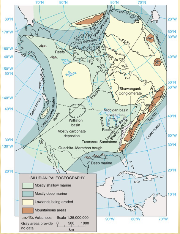
Additionally, significant evaporite deposits (halite, gypsum, anhydrite) formed in restricted basins (like the Michigan and Appalachian Basins) under arid climatic conditions, as depicted in FIGURE 10-31.
DEVONIAN PALEOGEOGRAPHY(데본기 고대 지리)
The Devonian Period ( to Ma) in eastern North America was dominated by the Acadian orogeny. This mountain-building event was caused by the collision of a volcanic island arc or an exotic terrane, specifically the Avalon or Carolina terrane, with the eastern margin of Laurentia. 데본기동안 북아메리카 동부는 Acadian Orogeny의 영향을 크게 받음. 아발론(Avalon) 혹은 Carolina terrane이 로렌시아 대륙의 동쪽 경계부와 충돌 하면서 발생함.
This powerful collision resulted in the formation of thick sequences of intensely(강하게,심하게) folded and faulted sedimentary rocks, which were interlaid(끼여있는, 층층이 섞여 있는) with rhyolitic volcanic rocks (indicating explosive(폭발적인), felsic volcanism) and significant granitic intrusions (plutons formed from melted crustal material and magma from subduction). These geological features provide strong evidence for the subduction of oceanic crust followed by continental collision, as detailed in studies by C. R. Scotese et al. (1979) published in the Journal of Geology.
The Devonian Period is a pivotal time in Earth’s history, marked by the rise of forests and a major mountain-building event in eastern North America.
Evolution of Trees and Global impact
The key evolutionary event was the development of lignin, the complex molecule that provides structural rigidity and makes plants woody(목질)
Evolution of Trees = Devonian Period
woody(목질): 식물의 줄기나 가지가 단단하고 딱딱한 구조로 발달한 성질.
lignin(리그닌):식물의 세포벽(cell wall)속에 들어 있는 단단한 고분자 물질. 주로 목질식물(woody plants)의 줄기,가지,나무껍질 등에 많이 들어 있음. lignin = 나무가 “딱딱해지는 이유”
Climate Change(Ice Age)
Mechanism(작용): Trees “eat” sunlight and convert atmospheric(대기,공기의) carbon dioxide() into wood(organic carbon). - 나무는 태양빛을 먹고 대기 중의 이산화탄소를 목재(organic carbon = 유기 탄소)로 전환된다.
Result: The massive uptake(대량 흡수) of () by evolving forests(진화하는 숲) dramatically pulled down the () concentration(농도,집중,농축도) in the atmosphere. - 진화하는 숲의 의해 대량의 이산화 탄소가 흡수되면서 대기중 이산화탄소 농도가 급격하게 감소
Consequence: This reduction in greenhouse gas led to a significant(중요한,상당한,뚜렷한) global cooling event, causing an ice age that lasted for approximately 100,000,000 years. - 온실가스의 감소는 지구 전체의 기온을 크게 낮추는 현상을 일으켰고, 그 결과 약 1억년 동안 지속된 빙하기가 발생.
global cooling event: 전 지구적 냉각 현상.
Eutrophication(부영양화) and Black Shale Formation
Dead Plant Debris(죽은 식물 잔해): Dead plant material(organic fertilizer(비료)) filled waterways, epicontinental seas(대륙 내부의 얕은 바다), and foreland basins(전산맥 분지).
Eutrophication(부영양화) Process: This influx of nutrients(영양분의 유입) caused massive algal blooms(rapid overgrowth of algae).
- The algae consumed(사용했다, 섭취했다) the nutrients, then died. - 조류가 영양분을 다 먹고 나서 죽었다.
- The decomposition(분해) of the dead algae consumed the oxygen() in the water, leading to anoxic(oxygen-depleted) conditions. 죽은 조류가 분해되면서 물속의 산소를 소모하여 무산소 상태를 초래함.
Black Shale Formation(흑색 셰일 형성): As this organic-rich mud sank to the seafloor and was buried(매장되다,덮이다), it transformed over time into characteristic black shale deposits. - 유기물이 풍부한 진흙이 바다 바닥으로 가라앉아 묻히면서 시간이 지나 특징적인 흑색 셰일 퇴적물로 변함.
Eutrophication(부영양화): 호수 또는 강, 바다에 “영양분(질소(N),인(P)같은 영양분(nutrients)이 너무 많이 쌓여서 물이 오염되는 현상)
algae(조류): 물속에서 사는 광합성 생물로, 작게는 미세 플랑크톤부터, 크게는 미역,다시마 같은 해조류까지 포함.
algal bloom(대규모 조류 번성 현상): 물속에 영양분이 너무 많아져서 조류가 폭발적으로 번식하는 현상.
Biological Evolution
The environmental changes during the Devonian spurred major evolutionary leaps(급격한 진화적 발전), particularly in vertebrates(척추동물).
Fish and Atmosphere
Atmoshpere(대기): Trees globaly oxygenated(산소가 풍부한) the atmosphere
Fish Evolution: Fish evolution took off(급격히 발전했다) in the Devonian, giving it the nickname “Age of Fishes.” - Devonian 동안 물고기가 급격히 발점됨으로써 “물고기의 시대”라는 별명을 얻게 됨.
Evolution of Tetrapods(Amphibians(양서류)(사지동물):
-In the suffocating(숨이 막히는,답답한), low-oxygen waters(due to eutrophication(부영양화)/algal decay(썩다,붕괴,쇠퇴)), fish gasping(숨을 헐떡이는) for air were pressured to evolve. 부영양화와 조류의 부패로 인해 산소가 부족하고 답답한 물속에서 숨을 쉬기 위해 물 위로 올라오던 물고기들이 진화의 압력을 받게됨.
- They leaned on their fins(지느러미) to breathe near the surface or in very shallow waters. - 그들은 지느러미에 몸을 의지하여, 수면 근처나 매우 얕은 물속에서 숨을 쉬었다.
- Eventually, these fish evolved into the first amphibians(four-limbed vertebrates). 결국, 이러한 물고기들은 최초의 양서류(사지를 가진 척추 동물)로 진화하였다.
Evolution of Reptiles(파충류의 진화)(carboniferous period(석탄기)
Selective Pressure(선택 압력): Rapidly changing sea levels created an environment where eggs laid in water were frequently threatened by drying out. - 급격하게 변하는 해수면은 물속에 알을 낳는 생물의 알이 자주 말라버릴 위험에 처하는 환경을 만듬.
Evolutionary solution: Reptiles evolved from amphibians with the crucial development of the amniotic or leathery egg, which allowed them to reproduce fully on land without returning to water. -파충류는 양서류로부터 진화했으며 암니오틱 알 또는 가죽 같은 껍질의 알이라는 중요한 발달을 통해 물로 돌아가지 않고도 완전히 육상에서 번식할수 있게 됨.
The Acadian Orogeny
The second major mountain-building event in the Appalachian region.
Type of Event: The Acadian orogeny was a major collisional event.
Collision: it involved the collision of Europe(part of Baltica) and North America(Laurentia)
Tectonic Result: This created really big mountains along the eastern margin of North America.
Sedimentary Result: The massive mountains led to the formation of a deep foreland basin to the west, which was filled by a very large clastic wedge of eroded sediment, known as the Catskill Clastic Wedge.
exotic terrane(이질 테레인): 원래 다른 대륙이나 해양판에서 형성되었다가, 판의 이동(plate movement)을 통해 현재의 대륙에 충돌하거나 부착(accretion)된 지각 조각(crustal blcok)을 의미.
rhyolitic(유문암질)- 끈적끈적한 밝은색 화산암