EAS 209 - Lecture 22
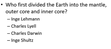
Inga Lehmann
Inga Lehmann (1888–1993) was a geophysicist who studied Earth's interior using seismic waves generated by earthquakes.
Originally trained as a mathematician before moving into geophysics.
Noticed that seismic wave intensity and waveforms differed depending on the location of seismic stations.
Investigated these differences and developed a hypothesis about Earth's internal structure.
Proposed the modern model of Earth consisting of:
Crust.
Mantle.
Liquid outer core.
Solid inner core.
A discontinuity associated with the core is named the Lehmann Discontinuity in her honor.
Lived to over 100 years old and was a highly influential scientist.

ANS: C
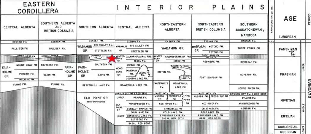
Winterburn Group Overview
Follows deposition of:
Elk Point Group → when sea level was low + evaporites forming.
Beaverhill Lake Group → more carbonates.
Woodbend Group.
Elk Point Group formed during low sea level conditions.
Beaverhill Lake Group formed as sea level began rising and carbonate deposition increased.
Woodbend Group represented ideal reef-building conditions.
During Woodbend time:
Sea level was favorable.
Environmental conditions supported extensive reef growth.
Leduc reefs flourished.
Winterburn Group marks the beginning of declining reef conditions.
Sea level began falling during Winterburn time.
Reef growth became less favorable as marine environments became shallower.
Frasnian–Famennian Boundary
Located within the interval being discussed during Winterburn deposition.
Corresponds to the Late Devonian mass extinction.
One of the most significant extinction events in Earth's history.
Many Winterburn-equivalent deposits are not preserved in the Cordillera.
Mountain exposures preserve:
Woodbend equivalents.
Wabamun equivalents.
Much of the Winterburn interval is missing in the mountains.
Loss of preservation is unfortunate because the Frasnian–Famennian extinction occurred during this interval.
Sea-Level Fall During Winterburn Time
Retreat of the seas shifted the platform margin back towards NW.
This was in general a poor interval for reef growth, but much oil is trapped in porous Nisku Formation carbonates where they are draped over underlying Leduc reefs (e.g. Leduc No. 1); this is caused by differential compaction of the intervening ireton shales.
Marine waters gradually retreated.
Falling sea levels reduced ideal reef-building environments.
Reefs were no longer growing under optimal conditions.
Carbonate deposition still occurred despite declining reef growth.
Nisku carbonates continued to form.
Nisku carbonates later became important oil and gas reservoirs.
Differential Compaction and Hydrocarbon Traps
Nisku carbonates were deposited above older Leduc reefs.
Differential compaction created structural traps for hydrocarbons.
Stratigraphic sequence:
Cooking Lake Platform.
Leduc reefs.
Duvernay Shale.
Ireton Formation.
Nisku Formation.
Wabamun Group.
Ireton shale is clay-rich and highly compressible.
Carbonates such as limestone are much less compressible.

Why Shales Compact More Than Carbonates
Shales contain platy clay minerals.
Clay particles are initially arranged randomly.
Compression causes clay particles to align parallel to one another → can be compacted a lot.
Alignment reduces pore space.
Porosity decreases significantly during compaction.
Carbonates generally retain their structure during burial.
As a result:
Shales compact substantially.
Carbonates compact relatively little.
Things like limestone doesn’t compress easily (unlike shale).
Differential Compaction:
Shales → compacted.
Where there is carbonates (more than shales) it is not compacted the same the shales are.
Remains a high.
Structures in the subsurface are formed based on the compressibility based on the shales versus the reef complexes.
Hydrocarbons tend to migrate to high points (same with water) → due to buoyancy factors.
As a result, hydrocarbons migrate and become trapped on the arch.
Arch is formed through sediment overlying it through time.
Compaction is greater off reef.
Formation of Differential Compaction Structures
Areas containing thick shale sequences compact more.
Areas underlain by reefs or carbonates compact less.
Carbonate-rich regions remain relatively elevated.
Overlying layers drape over these highs.
Creates subtle arch-like structures in the subsurface.
These structures are not caused by tectonic deformation.
They develop solely from differences in sediment compaction.
Hydrocarbon Accumulation
Oil and gas migrate upward due to buoyancy.
Hydrocarbons move toward structural highs.
Differential compaction arches provide trapping geometries.
Hydrocarbons accumulate beneath impermeable seals.
Many economically important reservoirs formed this way.
Nisku Formation Lithology - Amphipora
Amphipora resembles coral but is sponge-like in nature.
Often occurs within mud-supported deposits.
Deposits are classified as floatstones because:
Mud supports the framework.
Amphipora fragments are abundant.
Stylolites
Stylolites appear as irregular black jagged lines in carbonate rocks.
Represent surfaces where dissolution occurred.
Despite limestone being generally resistant, with enough pressure and high temperature the limestone can actually dissolve.
As a result, the carbonate dissolves away. Clays and heavy minerals (that survive the pressure and temperature) remain.
Carbonate material dissolves and is removed by fluids.
Insoluble residues remain behind.
Residues commonly include:
Clay minerals.
Heavy minerals.
Amount of dissolved rock is difficult to determine.
Presence of stylolites indicates loss of part of the rock record.
Important sedimentary contacts may be removed by dissolution.
Nisku Dolomitization
Some Nisku deposits are heavily dolomitized.
Dolomitized rocks are typically fine-grained.
May contain wisps of preserved mud.
Generally display limited visible porosity in hand sample.
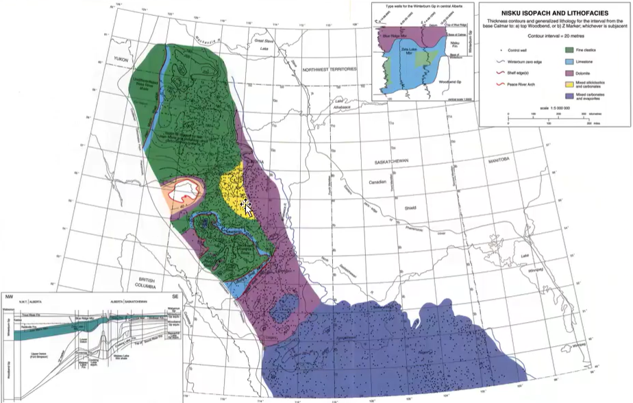
Nisku Paleogeography
Nisku deposition occurred across much of Alberta.
Depositional environments included:
Carbonates.
Dolomites.
Clastics (green).
Mixed carbonate-evaporite systems.
Evaporites became more common toward the Williston Basin.
Indicates increasingly restricted marine conditions.
Reflects continued sea-level decline.
A lot of the Nisku have been dolomitized.
Zeta Lake Member
Consists of isolated pinnacle reefs.
Occurs within shale basins.
Commonly associated with the Wild River Subbasin.
Pinnacle reefs are surrounded by deeper-water basin sediments.
Many Zeta Lake reefs became dolomitized.
Represent isolated reef growth centers within basinal settings.
Nisku Shelf and Basin Relationships
At the western edge of the Nisku Formation platform: isolated pinnacle reefs at West Pembina.
Nisku platform occupied shallower marine areas.
Shale basins developed in deeper water.
Zeta Lake pinnacle reefs formed within shale basins.
Nisku deposits overlie older Leduc reef complexes.
Cooking Lake Platform remains beneath both systems.

Oil and Gas in Pinnacle Reefs
Pinnacle reefs commonly contain oil and gas accumulations.
Green is oil and red is gas.
Reservoir quality results from:
High porosity.
High permeability.
Reefs occur near shelf margins.
Preferred growth location was the medial ramp.
Medial ramp provided:
Adequate sunlight.
Appropriate water depth.
Hydrocarbon pools commonly align with these reef trends.
Vertical Exaggeration in Cross Sections
Many geological cross sections use vertical exaggeration. They are not 1:1 measurements.
Vertical scale is larger than horizontal scale.
Makes structures appear more pronounced.
Pinnacle reefs often look like tall towers in exaggerated sections.
In reality, reefs were much broader and less steep.
Without vertical exaggeration, reefs appear as modest topographic highs.
Not ein passing that “pinnacle reefs” are in fact tablet/Aspirin-shaped.
Late Winterburn Conditions
Sea level continued falling.
Reef development declined further.
Evaporites and clastic sediments became increasingly common.
Blue Ridge Member records these more restricted conditions.
Peace River Arch remained exposed as an island, but mantled by clastics.
Clastic sediments continued to be shed from the arch.
The Winterburn Group ended with deposition of evaporative clastics.
Kalmar Formation
Overlies the Nisku Formation → sharp contact.
Characterized by calcareous shale.
Commonly has a greenish coloration.
Similar to the Duvernay in carbonate content.
Acts as a seal over Nisku reservoirs.
Contact with the Nisku is sharp and distinct.
Frasnian–Famennian Mass Extinction
Occurred near the end of Winterburn deposition.
One of the Big Five mass extinctions.
Took place approximately 360 million years ago.
Consisted of two major extinction pulses.
Particularly devastated tropical marine ecosystems.
End of the Winterburn:
End of the Winterburn deposition was also coincident with worldwide extinction of the Devonian reef community.
Consequently, for the balance of the Kaskaskia Sequence, there were no more reefs (thus, none in the Wabamun Group, next).
Drastic difference from the Winterburn to the Wabamun. The Winterburn has corals, stromatoporids, etc. The Wabamun has mostly calcium carbonate mud.
Unlike the Cretaceous mass extinction, there is no crater (like an easy depiction of a “smoking gun”). It’s unclear what caused it.
Devonian Extinction - 1st Pulse:
Second of the “Big Five” mass extinction.
2 extinction pulses caused by cooling events.
Both cooling events are marked by positive O and C isotope excursions.
1st pulse hit tropical taxa: reef builders, ammonoids, brachiopods, and placoderms).
Coral-Strome reefs never fully recovered.
Cold water inhabitants were not heavily affected (consistent with cooling as the main cause).
Spread of cold-adapted silica sponges from deep to shallow seas also supports cooling as the cause.
Evidence for Cooling
Positive oxygen isotope excursions indicate cooling.
Positive carbon isotope excursions also occur.
Cold-water organisms survived relatively well.
Silica sponges expanded into shallow marine environments.
Extensive glaciation developed.
Second Extinction Pulse
Second pulse of extinctions: less severe…
Placoderms went extinct and planktonic acritarchs suffered major extinctions.
Second pulse of cooling: most severe than the first one.
Glacial deposits spread to regions 30 degrees south of the equator indicating widespread glaciation.
The second pulse of extinctions would’ve been more devastating if the initial cooling event hadn’t already wiped out warm-adapted species.
Associated with even stronger cooling.
Glaciers expanded to regions near 30° south latitude.
Warm-adapted species suffered major losses.
Placoderm fishes became extinct.
Oceanic Anoxia
But cooling wasn’t the only cause…
From mid to late Devonian, oceanic bottom waters became anoxic.
Oxygen requiring benthic organisms died, tropical reef communities were hit hard.
There were frequent sea-level changes, with one sea-level rise associated with the onset anoxic deposits.
Each sea level rise was followed by glaciation and sea-level fall. The most severe during the second pulse of extinctions.
Bottom waters became oxygen depleted.
Oxygen-requiring benthic organisms died.
Reef ecosystems were especially vulnerable.
Anoxia coincided with major ecological disruption.
Role of Land Plants
Vascular plants spread across continents during the Devonian.
Plants evolved:
Deep root systems.
Greater height (from 30cm to 30m) as a result of root systems.
Evolution of seeds permitted plant growth in drier (previously uninhabited) areas.
Roots accelerated weathering of bedrock and formed deep layers of soil.
Thick soils developed for the first time.
Weathering and Nutrient Input
Soil promotes weathering, which transports nutrients to the ocean causing eutrophication and anoxia.
Increased weathering transported nutrients to the oceans.
Key nutrients included:
Phosphorus.
Nitrogen.
Nutrient influx triggered algal blooms.
Decomposition of algae consumed dissolved oxygen.
Resulted in widespread oceanic anoxia.
Cooling and Glaciation
Forest expansion removed CO₂ from the atmosphere.
Weathering also consumed atmospheric CO₂.
Ultimate result of both of these causing cooling.
Lower CO₂ levels produced global cooling.
Glaciation expanded.
Glaciation and subsequent sea level fall following the mild climate of the Devonian also caused extinctions.
Dropdown of C eventually pulled Earth out of greenhouse that into icehouse that continued through the Carboniferous and Permian.
Warm-adapted species experienced extensive extinction.
Additional Extinction Hypotheses
Nearby supernova may have damaged the ozone layer.
Increased UV radiation could have harmed organisms.
Evidence includes UV-damaged fossil spores and pollen.
Volcanism may also have contributed.
Large flood basalt eruptions occurred in Siberia.
Sulfur dioxide emissions may have increased planetary reflectivity.
Increased reflectivity could have promoted cooling.
Extraterrestrial Cause…?
Some attribute the extinctions to UV damage.
UV damage to fossil pollen and spores during this event suggests long-term destruction of ozone.
It has been hypothesized that a nearby supernova damaged ozone leading to massive UV damage to life, triggering mass extinctions.
However, destruciton of the ozone would’ve required sustaining global warming (rather than cooling…)
Volcanic Activity…?
Volcanism has also been suggested as a cause of these extinctions.
Ar dating confirmed correlation between eruption of the Viluy traps on the Siberian Craton and the first pulse of extinctions.
SO2 ejected into the atmosphere form the Viluy volcanism could’ve formed high albedo sulfuric acid aerosols causing rapid global cooling.
Overall Cause of the Devonian Extinction
Likely resulted from multiple interacting factors:
Oceanic anoxia.
Cooling.
Glaciation.
Sea-level fluctuations.
Volcanism.
Potential UV damage.
No single universally accepted cause exists.
Wabamun Group
Deposited after the Winterburn Group.
Equivalent to the Palliser Formation in the mountains.
Sea level continued falling.
Carbonate deposition became increasingly restricted.
Large limestone bodies transitioned basinward into shale.
Palliser Formation
The Palliser formation is one of the spectacular cliff-formers of the Front Ranges of the Rocky Mountains.
There was continued regression of sea level to the NW, with limestones again shaling out to NW (for both the Palliser and the Wabamun).
Forms prominent cliffs throughout the Rocky Mountains.
Common around:
Canmore.
Jasper.
Grassi Lakes.
Extremely thick carbonate succession.
Dominated by calcareous mudstones.
Contains very few fossils.
Represents post-extinction conditions.
Evidence for Mass Extinction in the Rock Record
Winterburn rocks contain:
Corals.
Stromatoporoids.
Diverse fossils.
Wabamun/Palliser rocks contain:
Very few fossils.
Mostly carbonate mud.
Abrupt disappearance of reef communities supports occurrence of a major extinction event.
Wabamun Lithology
Commonly displays pinprick porosity.
Little evidence of bioturbation.
Fossils are rare or absent.
Breccias occur locally.
Stylolites may form after deposition through dissolution.
Exshaw Formation
Marks the end of the Devonian sequence.
This period was closed out by deposition of the Exshaw formation of Bakken formation that spans the Devonian/Mississippian boundary.
Represents a major marine transgression.
Sea level rose again after prolonged regression.
Organic-rich shale deposited across the region.
Shale blanketed older formations.
Characteristics of the Exshaw Formation
Dark organic-rich shale.
Contains evidence of life.
Bioturbation is present.
Burrows such as Chondrites occur.
Organisms mined sediment for organic matter.
Bakken Formation
Equivalent to the Exshaw Formation in Saskatchewan and the United States.
In the Bakken formation, a number of siltstone units have become prominent hydrocarbon reservoirs.
Has a different name because it has a different location.
Major unconventional oil and gas resource.
Organic-rich shale generates hydrocarbons.
Technological advances such as hydraulic fracturing made production economically viable.
Cordilleran Equivalents:
No middle Devonian.
Flume Formation = Beaverhill Lake Group.
Exposure of grey Flume Formation carbonates along Yellowhead Highway.
Fairholme Group between Flume Formation and Wabamun Group; significant unconformity at its top.
Exposure of Perdrix Formation shales (= Ireton/Duvernay) and older Flume Formation carbonates Yellowhead Highway.
Mountain Formation Equivalents
Flume Formation = Beaverhill Lake Group equivalent.
Palliser Formation = Wabamun Group equivalent.
Exshaw Formation = Bakken equivalent.
Different names are used because the rocks occur in different geographic settings despite being time-equivalent.
Recognizing Devonian Rocks in the Mountains
Fossil-rich units generally belong to older Devonian intervals.
Common fossils include:
Stromatoporoids.
Corals.
Stachyodes.
Many middle Devonian deposits are absent due to non-preservation.
Palliser Formation is typically fossil-poor and dominated by carbonate mudstones.
ANS: A