EAS 209 - Lecture 26
Sedimentology vs. Structural Geology
Geology contains many different branches and specialties.
Throughout most of the course so far, the emphasis has been on sedimentology.
Sedimentology focuses on:
How sediments were deposited.
Ancient depositional environments.
Reconstruction of past landscapes.
Interpretation of ancient environmental conditions.
Sedimentologists attempt to answer questions such as:
How was sediment laid down?
What type of environment existed when the sediment was deposited?
What did the landscape look like at that time?
Was the area marine, terrestrial, shallow water, deep water, etc.?
Structural geology focuses on a different set of questions.
Structural geology is concerned with what happened to rocks after deposition.
Structural geologists study:
Deformation.
Folding.
Faulting.
Uplift.
Mountain building.
Structural geology examines how rocks became arranged in their present-day positions.
Rather than asking how rocks formed, structural geologists ask:
How did the rocks end up where they are now?
What forces acted upon them?
How were they folded or faulted?
What tectonic events affected them?
Structural geologists commonly:
Map mountain belts.
Identify fault systems.
Locate folds.
Determine orientations of rock layers.
Reconstruct tectonic history.
Structural geology is particularly important in the petroleum industry.
Oil and gas accumulations are often controlled by geological structure.
Structural geologists help identify:
Anticlines.
Fault traps.
Structural closures.
Other potential hydrocarbon traps.
Geological Mapping & Structural Measurements
Structural geologists spend large amounts of time performing field mapping.
They often travel considerable distances collecting measurements from exposed rocks.
One of the primary tools used is a geological compass.
Geological compasses are more advanced than ordinary compasses.
In addition to measuring direction, they contain an inclinometer.
An inclinometer allows measurement of the angle at which a rock layer is tilted.
Structural geologists measure:
Strike.
Dip.
Bed orientation.
Strike refers to the orientation of a rock layer.
Dip refers to the angle at which the layer slopes downward.
By collecting many measurements across a region, geologists can:
Map folds.
Map faults.
Determine structural trends.
Understand regional deformation patterns.
These measurements allow reconstruction of geological history and mountain-building processes.
Florence Bascom (1862–1945)
Florence Bascom is highlighted as the geologist of the day.
She lived from:
1862–1945.
She is considered the first major American woman geologist.
She completed:
Master's degree.
PhD.
Both were completed at Johns Hopkins University.
She was the first woman known to earn a PhD in geology there.
Bascom was a highly productive researcher.
Her work focused heavily on:
Mineralogy.
Gravels.
Glacial sediments.
Much of her research dealt with relatively recent geological deposits.
She published extensively throughout her career.
She later became a professor.
She founded the geology department at the institution where she taught.
She is recognized as one of the first women geology professors.
She also worked with the United States Geological Survey.
She became an associate of the USGS.
She was the first woman to achieve that position.
Her career included numerous historic firsts for women in geology.
This is particularly notable because she worked during the late 1800s and early 1900s.
At that time, opportunities for women in science were far more limited than today.
The instructor recommends reading more about Florence Bascom.
A good source suggested is:
Encyclopedia Britannica.
Britannica is recommended over Wikipedia for introductory background information.

ANS: True
These names refer to the same geological structure.
The naming changed as geological work expanded from the Permian into the Triassic.
The structure represents:
The collapsed West Alberta Ridge.
The ridge originally existed during the Devonian.
After collapse, it became a trough-like feature.

Metamorphic Rocks & Metamorphic Grade
Image features different types of metamorphic rocks.
The important rock types for this lecture are:
Green schist.
Amphibolite.
The diagram plots:
Temperature.
Pressure.
Pressure can generally be thought of as increasing with depth.
As rocks are buried deeper:
Pressure increases.
Temperature generally increases.
Different combinations of pressure and temperature produce different metamorphic rocks.
Green schist forms under:
Relatively low temperature.
Relatively low pressure.
Because of this, green schist is considered a lower-grade metamorphic rock. Underwent less suffering than amphibolite.
Amphibolite forms under:
Higher temperature.
Similar pressure compared to green schist.
To transform green schist into amphibolite:
Temperature must increase.
Pressure remains relatively similar.
Amphibolite is therefore a higher-grade metamorphic rock than green schist.
Blue schist forms under:
Higher pressure.
Similar temperature compared to green schist.
To transform green schist into blue schist:
Pressure must increase.
Temperature does not need to increase significantly.
Metamorphic grade refers to how much a rock has been altered by pressure and temperature.
Higher metamorphic grade indicates:
Greater pressure.
Greater temperature.
Greater overall metamorphism.
Relative metamorphic grades:
Green schist = lower grade.
Amphibolite = higher grade because of higher temperature.
Blue schist = higher grade because of higher pressure.
The key takeaway:
Metamorphic rocks record the pressure-temperature conditions they experienced.
Different metamorphic rock types tell geologists about the geological environment in which they formed.
Plate Tectonics Review Paper
Review journals are useful because they:
Summarize large areas of research.
Provide background information.
Introduce major concepts.
Reference important foundational studies.
Review papers are often a good starting point when learning a new topic.
They typically:
Cover key ideas.
Explain terminology.
Summarize previous research.
Point readers toward important primary sources.
The paper specifically discusses:
When plate tectonics may have started on Earth.
An important feature of the paper is its overview of plate tectonic processes.
It explains:
Structure of Earth.
Mantle processes.
Plate movement.
Subduction.
Other tectonic mechanisms.
Students interested in a deeper understanding of plate tectonics are encouraged to consult the paper.
The paper also examines evidence that plate tectonics may have been operating during the Archean.
The Archean predates:
Cambrian.
Paleozoic.
Most familiar geological history.
The paper is approximately:
42 pages long.
Students do not need to read the entire paper.
Useful approaches include:
Reading the abstract.
Reading the conclusions.
Examining figures.
Reading figure captions.
These sections often provide the main ideas without requiring a full read-through.
The Cordillera
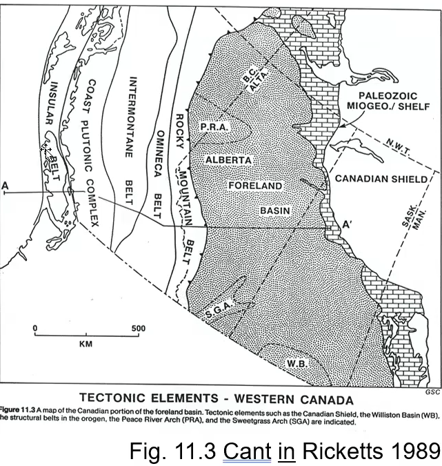
The Cordillera refers essentially to much of British Columbia and the western mountain region of Canada.
It is divided into five major belts.
These belts are distinguished primarily by:
Rock type.
Metamorphism.
Geological history.
The five major belts are:
Rocky Mountain Belt.
Omineca Belt.
Intermontane Belt.
Coast Plutonic Complex.
Insular Belt.
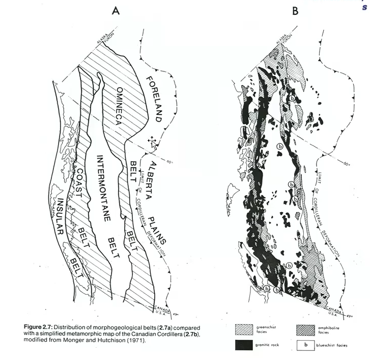
Rocky Mountain Belt:
Also known as the Foreland (Fold and Thrust) Belt, and the Coast Plutonic Complex as the Coast Belt.
Granitic rock → an igneous rock (black in the image).
Plutons → lava that came up and solidified as granite.
Regional Geological Features
The Peace River Arch is highlighted on the regional map.
The Peace River Arch was discussed previously in the course.
Originally:
It existed as a structural high.
It influenced sedimentation.
Later:
It collapsed.
It became an embayment.
The map also shows the foreland basin.
The foreland basin is important because:
Most sedimentary deposits discussed throughout the course accumulated there.
The Sweetgrass Arch is also shown.
Like the Peace River Arch, it represents a tectonic high.
Such highs influence:
Sediment transport.
Deposition patterns.
Basin development.
Why the Cordillera is Divided into Belts
The Cordillera is divided according to rock type and geological history.
Different regions contain different combinations of:
Sedimentary rocks.
Metamorphic rocks.
Igneous rocks.
Certain metamorphic rock types occur preferentially within specific belts.
Examples include:
Green schist facies.
Amphibolite facies.
Blue schist facies.
Granitic rocks are also common in some areas.
Granite is not a metamorphic rock.
Granite is:
An igneous rock.
Formed from magma.
Granitic bodies are commonly called plutons.
Plutons form when magma:
Rises upward.
Intrudes surrounding rocks.
Cools and solidifies underground.
The term "pluton" often refers to large intrusive igneous bodies.
Metamorphism Across the Cordillera
Green schist facies indicate:
Lower pressure.
Lower temperature.
Lower-grade metamorphism.
Amphibolite facies indicate:
Higher temperature.
Greater metamorphic intensity.
Blue schist facies indicate:
Higher pressure.
Conditions commonly associated with subduction.
Mapping where these rocks occur allows geologists to reconstruct tectonic history.
Some belts contain:
Extensive metamorphic rocks.
Numerous plutons.
Other belts contain:
Little metamorphism.
Mainly sedimentary or volcanic rocks.
The Omineca Belt contains:
Significant metamorphism.
Numerous plutonic intrusions.
The Intermontane Belt contains:
Relatively little metamorphism.
Some plutons.
Few major metamorphic facies.
The Coast Belt again contains:
Metamorphic rocks.
Plutons.
Extensive crustal alteration.
Because metamorphism occurs strongly in two major regions:
Omineca Belt.
Coast Belt.
Some geologists interpret this pattern as evidence for multiple episodes of mountain building.
The idea is that:
Rocks in one area were compressed and heated.
Later, rocks in another area were compressed and heated.
Multiple tectonic events affected different parts of the Cordillera.
These differences in rock type help define the boundaries between belts.

Cordilleran Mountain Building During the Cretaceous
During mountain building the sediment source became the southwest, rather than the northeast (Canadian Shield).
This last phase is called the Laramide Orogeny, and continued into the early Cenozoic.
Two major mountain-building phases:
Older pre-Cretaceous events (Columbian).
Younger post-Cretaceous events (Laramide).
One (pre) important event is the Columbian Orogeny.
Another (post) major event is the Laramide Orogeny.
Orogeny simply means:
Mountain-building episode.
The Laramide Orogeny is particularly important because it produced much of the Rocky Mountains visible today.
During mountain building:
Rocks were uplifted.
Mountains formed.
Erosion intensified.
Estimates suggest that enormous amounts of rock were removed by erosion after uplift.
Some estimates propose:
Up to 10 km of sediment may have been removed from mountain belts.
Estimates are debated.
However, there is strong evidence for extremely large amounts of erosion.
After uplift:
Sediment was transported eastward.
Sediment accumulated in adjacent basins.
Glaciation later enhanced this erosion.
The Laramide Orogeny began during the Cretaceous.
Before major uplift:
Much of western Canada was marine.
Open ocean connections existed.
During uplift:
Western regions became exposed land.
Mountains formed.
Sediment began shedding eastward into basins.
This shift fundamentally changed depositional patterns throughout western Canada.

It appears that there was also significant NS transport.
Sediment Transport During the Jurassic
Geological evidence suggests sediment transport occurred from north to south.
Certain rock types found farther south appear to have originated from northern source regions.
Similar rock associations occur along transport pathways.
This suggests:
Long-distance sediment movement.
Regional-scale transport systems.
Maps identify:
Boreal northern regions.
Tethyan marine regions.
Hypothesized Jurassic continental margins.
During portions of the Jurassic:
Large parts of Alberta were exposed above sea level.
Sedimentation was limited in some areas because deposition was not occurring continuously.

Terranes & Accretion in the Cordillera
The five major Cordilleran belts explain large-scale geological divisions.
The five Cordilleran belts are only part of the story… all are individual little terranes.
The Cordillera is a collage of terranes.
However, each belt contains many smaller geological units called terranes.
These terranes make the Cordillera much more complicated than a simple sequence of belts.
A terrane is a package of rocks that:
Formed together.
Share a common geological history.
Share a common source region.
Were later attached to North America.
Examples of terrane origins include:
Island arcs.
Ocean floor fragments.
Deep marine deposits.
Continental fragments.
Accretion refers to the process by which these terranes became attached to the continent.
Terranes essentially collided with the western margin of North America and became welded onto it.
Over time, repeated accretion events gradually built western Canada.
Different terranes are represented by different rock types and geological histories.
Some terranes represent:
Ancient volcanic island chains.
Pieces of ocean crust.
Fragments of continental crust that broke away elsewhere.
The resulting pattern is extremely complex.
The Cordillera is therefore not a single geological unit.
It is a collection of many geological fragments that were assembled over time.
Maps show:
Island arc terranes.
Submarine sedimentary terranes.
Ancient ocean floor terranes.
Continental fragments.
These terranes form a patchwork across British Columbia and western Canada.
There are more than 200 recognized terranes within the Cordillera.
Terranes vary greatly in age.
Many formed between:
Mid-Paleozoic.
Jurassic.
In the extreme (over 200 terranes); most range from Mid Paleozoic to Mid Jurassic (except the Alexander Terrane of the Insular Belt… latest Proterozoic).
One notable exception is the Alexander Terrane.
The Alexander Terrane dates back to the late Proterozoic.
This makes it significantly older than many other Cordilleran terranes.
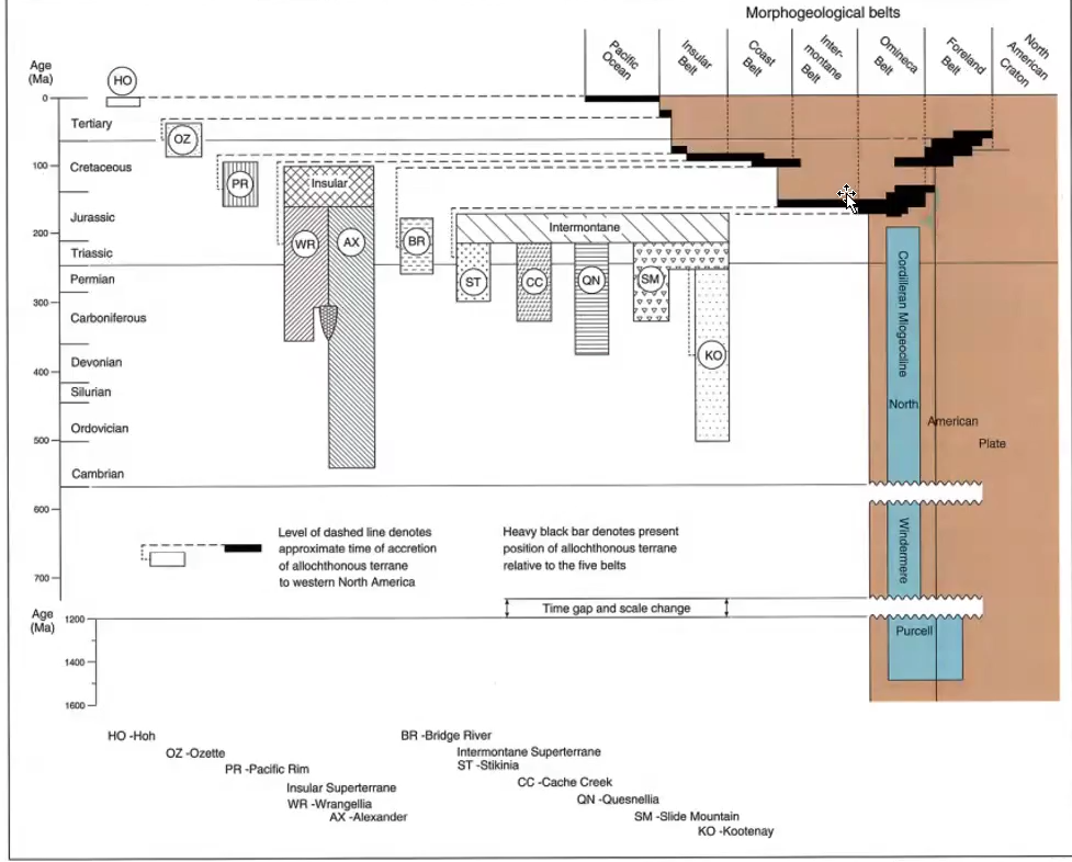
Terrane Accretion Through Time
Diagrams show when individual terranes became attached to North America.
Each terrane was added at a different time.
Some terranes were attached during:
Jurassic time.
Others were attached during:
Cretaceous time.
This means Cordilleran growth occurred gradually rather than all at once.
The diagrams track:
Time of accretion.
Present-day location.
Relationship to the major belts.
Some terranes occupy:
One belt.
Others extend across:
Multiple belts.
Examples include:
Slide Mountain Terrane.
Quesnellia Terrane.
Yukon-Tanana Terrane.
Many of these terranes were incorporated during the Jurassic.
Large portions of the Insular Belt were added during the Cretaceous.
Much of the Cretaceous accretion is associated with the Columbian Orogeny.
Every accretion event contributed to:
Compression.
Mountain building.
Metamorphism.
Crustal thickening.
Allochthonous → Means that they’re from somewhere else.
Cordilleran Margin: Passive to Active
Earlier in geological history, western North America behaved as a passive margin.
A passive margin is characterized by:
Relatively little tectonic activity.
Limited deformation.
Dominance of sediment deposition.
During passive margin conditions:
Sediments accumulated quietly.
Large depositional systems developed.
Examples include:
Purcell Supergroup.
Windermere Supergroup.
During the Devonian and Carboniferous:
Much of western Canada remained dominated by deposition.
Around the Jurassic:
Conditions changed dramatically.
The passive margin evolved into an active tectonic margin.
This change was caused by:
Terrane accretion.
Convergence.
Mountain building occurring in the west.
Consequences included:
Increased tectonic activity.
Uplift.
Compression.
Development of mountain belts.
As terranes collided with the continent:
Topographic highs formed.
Mountains developed.
Sediment sources appeared in the west.
Before this transition:
Sediment commonly accumulated in marine environments.
After the transition:
Newly formed mountains became sediment sources.
Erosion of these mountains supplied sediment into adjacent basins.
This shift is critical for understanding later Mesozoic sedimentation.
This led to the building of British Columbia.
This is a current snapshot.
It didn’t form all at once; its been influenced multiple times.
The Rocky Mountain Fold and Thrust Belt
The lecture now zooms into the Rocky Mountain Belt specifically.
The Rocky Mountain Belt is also known as:
Fold and Thrust Belt.
Foreland Fold and Thrust Belt.
This belt contains sedimentary rocks that were:
Originally deposited in relatively undisturbed settings.
Later compressed and deformed during mountain building.
The deformation occurred during repeated orogenic events.
Compression caused:
Folding.
Faulting.
Crustal shortening.
The rocks were squeezed together.
This shortening forced rock layers to:
Fold.
Break.
Move along thrust faults.
Subdivisions of the Rocky Mountain Belt
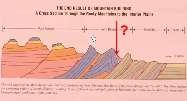
The Rocky Mountain Belt can be divided into several regions.
From east to west:
Plains.
Foothills.
Front Ranges (seeing the exposed rock, the snow-cap mountains. They are steeply dipping).
Main Ranges (Not as steep… form the center of synclines and anticlines).
If you erode the bottom of your rock, it is uncurved (hence its horizontal appearance).
Large, exposed rock. Called “castellated” because they look like castles.
These divisions reflect differences in:
Structure.
Exposure.
Degree of deformation.
Plains
The plains contain relatively undisturbed sedimentary rocks.
Rocks remain largely horizontal.
Deformation is minimal compared to mountain regions.
This area represents the least structurally disturbed part of the system.
Foothills
Moving westward leads into the foothills.
Rocks become increasingly deformed.
Characteristics include:
Folding.
Faulting.
Uplift.
However, much of the bedrock remains covered by:
Grass.
Soil.
Trees.
Because of vegetation cover:
Rock exposures are less common.
The foothills often appear as:
Large rolling hills.
Broad ridges.
They lack the dramatic exposed cliffs associated with the Rockies.
Front Ranges
Farther west are the Front Ranges.
This is where classic Rocky Mountain scenery begins.
Characteristics include:
Exposed rock.
High relief.
Steeply dipping strata.
Major folds.
Major thrust faults.
These are the mountains most people recognize when entering the Rockies.
Snow-capped peaks commonly occur within this region.
Rock layers often stand at very steep angles.
In many locations:
Strata approach vertical orientations.
Main Ranges
Beyond the Front Ranges lie the Main Ranges.
At first glance:
Rocks appear more horizontal.
This appearance is misleading.
The Main Ranges represent preserved cores of synclines.
A syncline is a downward-folded structure.
Originally:
Synclines were paired with anticlines.
Anticlines formed upward arches.
Extensive erosion removed much of the surrounding rock.
What remains today are:
Synclinal cores.
Flat-appearing remnants.
These preserved structures create the distinctive castellated appearance of many mountains.
"Castellated" means:
Castle-like.
Blocky.
Stepped.
The Main Ranges contain some of the most impressive mountain scenery in the Rockies.
Formation of the Rocky Mountains
The Rocky Mountains did not form during a single event.
Multiple episodes of:
Accretion.
Compression.
Mountain building.
contributed to their development.
Each terrane collision added:
Pressure.
Deformation.
Structural complexity.
The modern Rockies represent the cumulative result of many tectonic events over millions of years.
Foreland Belt (Rocky Mountains Proper).
The Foreland Belt is unusual in that it deforms sedimentary rocks of the Foreland Basin that owe their origin to mountain building.
Compressive stresses produced crustal shortening and thickening by a combination of thrust faulting and folding.
To the east of the Foreland Belt is the triangle zone.

The Triangle Zone
One of the most important structural features is the Triangle Zone.
This zone is bounded east by east-dipping strata and faults that are quite steep, but on the west by west-dipping strata and faults of the next zone.
Bounded by two different directions of dips.
The Triangle Zone occurs on the eastern side of the foothills.
It is bounded by:
East-dipping structures.
West-dipping structures.
Because opposite dipping structures meet:
A triangular geometry develops.
This geometry gives the Triangle Zone its name.
The Triangle Zone is characterized by:
Intense folding.
Intense faulting.
Complex structural relationships.
It is one of the most structurally complicated parts of the Rocky Mountain system.
The Triangle Zone is particularly important in Alberta petroleum geology.
Complex folding and faulting create:
Structural traps.
Reservoir compartments.
Hydrocarbon accumulations.
Many important oil and gas fields occur within this zone.

Turner Valley Field
Turner Valley is one of Alberta's most famous oil and gas fields.
Its success is closely related to Triangle Zone structures.
Hydrocarbons migrated through reservoir rocks.
Movement continued until faults and folds blocked further migration.
Fault displacement interrupted the migration pathway.
Oil and gas migrated up in the reservoir and it became trapped.
Over time:
Large hydrocarbon accumulations formed.
Structural deformation directly created the trapping mechanism.
Turner Valley therefore represents a classic example of a structural trap.
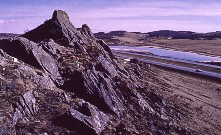
Sometimes rock can show for foothills: Mesozoic rocks are brought to the surface, and because they are generally not resistant, only low ridges of durable sandstone are seen.
If these rocks are exposed because of mountain building, the mountain building episode (or some accretion) must have occurred after these rocks were deposited.
Mountain building episodes post-Cretaceous.
Foothills
This zone is characterized y faulting of rocks, with a west dip to the faults and strata.
The foothills represent the transition between:
Undisturbed plains.
Highly deformed mountain ranges.
Rocks in the foothills are:
Folded.
Faulted.
Uplifted.
Structurally disturbed.
However, most of the bedrock is not continuously exposed.
Much of the region is covered by:
Grass.
Soil.
Forest.
As a result, the foothills often appear as:
Rolling hills.
Broad ridges.
Gentle topography.
Structural deformation is still present beneath the surface.
Many rock layers dip toward the west.
Numerous thrust faults occur throughout the foothills.
Thrust faults formed when compressional forces pushed rock packages over one another.
Arrows shown on structural diagrams indicate:
Direction of rock movement.
Direction of thrusting.
In a thrust fault:
One block moves upward relative to another.
Older rocks may be pushed over younger rocks.
Examples from the Foothills
Exposed foothill rocks commonly include:
Cretaceous sandstones.
Coal-bearing strata.
Folded sedimentary units.
Sandstones tend to be resistant to erosion.
Because of this resistance:
They often remain exposed after softer rocks have weathered away.
Coal-bearing units are also commonly exposed in foothill regions.
Many exposures show:
Small folds.
Tilted strata.
Clear evidence of compression.
Examples discussed include:
Bragg Creek.
Coleman.
Kingsfold near Cochrane.
These locations demonstrate that significant deformation affected Cretaceous rocks.
Despite deformation:
Most of the foothills remain vegetation covered.
Large continuous cliff exposures are uncommon compared to the Front Ranges.
Evidence for Post-Cretaceous Mountain Building
Several foothill exposures contain Cretaceous rocks.
These Cretaceous rocks have been:
Folded.
Tilted.
Faulted.
Uplifted.
This observation is extremely important.
If Cretaceous rocks are deformed:
The deformation must have occurred after the rocks were deposited.
Therefore:
Mountain building continued after the Cretaceous.
This serves as evidence for later mountain-building events.
Specifically:
The Laramide Orogeny must have occurred after deposition of these Cretaceous strata.
The logic is simple:
Rock must exist before it can be folded.
Therefore the folding event must be younger than the rock itself.
Front Ranges
Moving westward from the foothills leads into the Front Ranges.
The eastern limit to this zone is called the Mountain Front, and represents the point at which Paleozoic rocks are first exposed at the surface.
The Front Ranges represent the first major mountain belt encountered when entering the Rockies.
This region is marked by:
Dramatic topography.
Exposed bedrock.
High cliffs.
Steeply dipping strata.
The boundary between foothills and Front Ranges is called the Mountain Front.
The Mountain Front is defined by:
The first major exposure of Paleozoic rocks.
As soon as Paleozoic rocks begin appearing at the surface:
You have entered the Front Ranges.
This boundary generally follows major thrust faults.
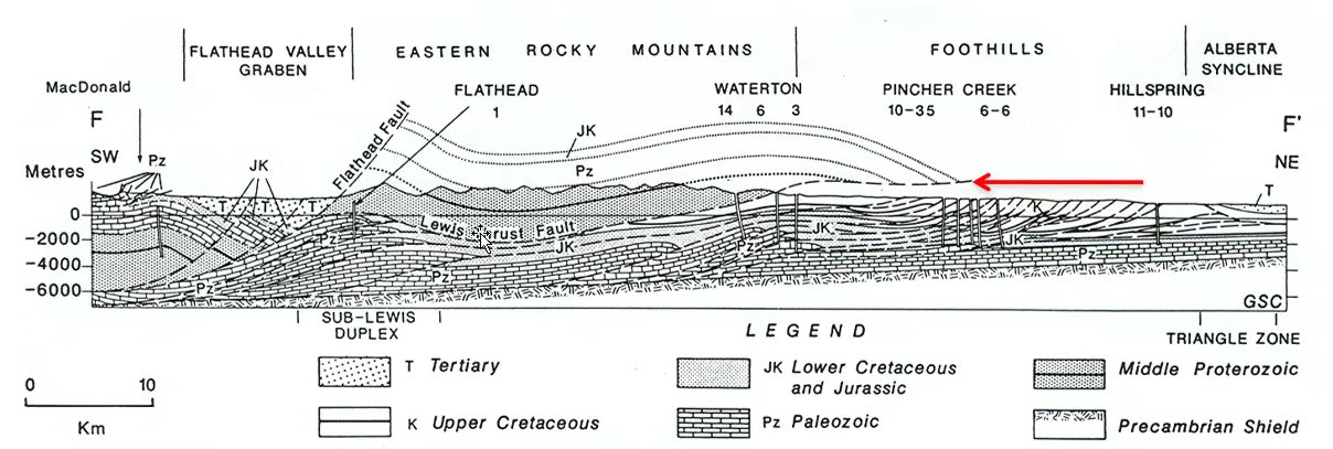
The margin of the Foothills will migrate eastward as erosion progresses.
Not in our lifetime.
Major Structural Features of the Front Ranges
The Front Ranges are dominated by:
Folding.
Thrust faulting.
Paleozoic carbonate rocks.
Important rock units include:
Palliser Formation.
Banff Formation.
Rundle Group.
These units are commonly exposed throughout the Front Ranges.
Carbonate rocks are resistant to erosion.
Because of this:
They frequently form cliffs.
They commonly form mountain ridges.
Much of the dramatic Rocky Mountain scenery is created by these resistant carbonate units.
Lewis Thrust Fault
One of the most important faults in the Rockies is the Lewis Thrust.
The Lewis Thrust is a major regional thrust fault.
It played a significant role in uplifting Paleozoic rocks.
The fault transported older rocks over younger rocks.
This is a hallmark of thrust fault systems.
Along the Lewis Thrust:
Paleozoic carbonate rocks were pushed over younger strata.
The Lewis Thrust is responsible for many of the prominent Front Range exposures.
It helped create:
High mountain ridges.
Cliff-forming units.
Large structural repetitions.
Responsible for a lot of the Paleozoic rock being thrust up to the surface.
Small little thrusts are found in between each large thrust.

Erosion & Changing Mountain Front Position
The position of the Mountain Front changes through geological time.
Erosion continuously removes rock.
Large amounts of material have been stripped away since mountain building occurred.
As erosion progresses:
The point where Paleozoic rocks first become exposed shifts.
Therefore:
The modern Mountain Front is not fixed permanently.
Over millions of years:
The boundary migrates.
The process is extremely slow.
Changes occur on geological timescales rather than human timescales.
Crow's Nest Mountain
Crow's Nest Mountain is one of the classic examples used to study Front Range structure.
It is located near:
Blairmore.
Coleman.
Crow's Nest Pass.
The area provides excellent exposures of the Lewis Thrust system.
Crow's Nest Mountain lies near the transition between:
Foothills.
Front Ranges.
The mountain clearly demonstrates relationships between:
Older Paleozoic rocks.
Younger Cretaceous rocks.
Palliser, Banff & Rundle
Three formations dominate many Front Range mountains:
Palliser Formation.
Banff Formation.
Rundle Group.
These formations are repeatedly emphasized throughout the lecture.
They are major cliff-forming units.
They produce much of the recognizable Rocky Mountain landscape.
These units were discussed previously in the course.
Stratigraphically they include:
Devonian rocks.
Carboniferous rocks.
Their resistance to erosion allows them to remain exposed while softer rocks weather away.
As a result:
They commonly form ridges.
They commonly form steep mountain faces.
Many Front Range mountains are visually dominated by these formations.

Crow's Nest Mountain as a Klippe
Crow's Nest Mountain is classified as a klippe.
A klippe is an isolated block of rock because of erosion.
It forms when erosion removes the surrounding rock.
Originally:
The isolated block was connected to a larger rock body.
Subsequent erosion separated it.
At Crow's Nest:
Allison Creek removed material between mountain sections.
This erosion isolated the remaining block.
The isolated remnant became a klippe.
A klippe is therefore:
A disconnected remnant.
Preserved after erosion removes connecting material.
The term is not unique to Crow's Nest Mountain.
It can be applied to any isolated structural remnant produced by erosion.
Lewis Thrust Relationships at Crow's Nest
The Lewis Thrust places older rocks above younger rocks.
Examples include:
Paleozoic rocks positioned above Cretaceous rocks.
Units involved include:
Belly River Group (Cretaceous).
Fairholme Group.
Palliser Formation.
Banff Formation.
Rundle Group.
The thrust fault can be traced across large distances.
It is visible throughout much of the Front Ranges.
The structure demonstrates the enormous scale of compressional deformation in the Rockies.

McConnell Thrust
Another major Rocky Mountain thrust fault is the McConnell Thrust.
In the image, the Cambrian Eldon upthrust over Cretaceous Belly River.
Cambrian rocks were thrust over younger Cretaceous rocks.
This inversion of age relationships is a key indicator of thrust faulting.
The fault can often be recognized by:
Broken rock.
Rubble zones.
Structural "suture" zones.
These disturbed zones mark the location where major movement occurred.
National Parks & the Front Ranges
The Front Ranges frequently coincide with the boundaries of Rocky Mountain national parks.
In many locations:
Crossing into a national park also means entering the Front Ranges.
This relationship is not perfect everywhere.
However, it provides a useful field guide.
Generally:
Foothills occur outside.
Front Ranges occur inside.
Exceptions occur in regions such as:
Saskatchewan Crossing.
Rocky Mountain House area.
The Mountain Front generally corresponds to the eastern boundary of the national parks such as Jasper, Banff, and Waterton Lakes NPs.
Foothills are not included in the National Park zone.
Front Range Landscape Pattern
There are long NW-SE ridges composed of resistant carbonates (e.g. Palliser/Wabamun and Rundle) alternating with valleys eroded into shales (e.g. Banff Formation, Mesozoic shales).
The strata and faults are often steeply dipping.
The rocks have subsequently been sculpted (i.e. Mount Rundle).
Front Ranges are characterized by alternating:
Resistant ridges.
Erodible valleys.
Resistant rocks include:
Palliser Formation.
Banff Formation.
Rundle Group.
Softer rocks commonly include:
Shales.
Mesozoic sedimentary units.
Resistant rocks form:
Long ridges.
Cliff faces.
Softer rocks form:
Valleys.
Low areas.
The result is a repeating pattern of:
Ridge.
Valley.
Ridge.
Valley.
This pattern extends over large portions of the Front Ranges.
Steeply Dipping Front Range Strata
One of the defining characteristics of the Front Ranges is the steep orientation of rock layers.
Many strata are:
Strongly tilted.
Nearly vertical.
Examples shown include:
Sawback Range.
Mount Collins.
Devonian strata in some locations are essentially vertical.
These steep orientations provide evidence for intense compressional deformation.
The Front Ranges therefore preserve some of the clearest evidence of Rocky Mountain tectonics.
Glaciation & Modification of the Rocky Mountains
Mountain building alone did not create the modern Rocky Mountain landscape.
After the major mountain-building episodes:
Extensive glaciation occurred.
Glaciers dramatically modified the mountains.
Ice preferentially occupied:
Existing valleys.
Low areas between ridges.
As glaciers moved:
They scraped bedrock.
They deepened valleys.
They widened valleys.
They removed large amounts of rock.
Glacial erosion enhanced pre-existing topography.
Areas that were already low became:
Lower.
Wider.
More pronounced.
Areas made of resistant rock remained elevated.
This increased the contrast between:
Mountain ridges.
Valley floors.
Many of the dramatic landscapes seen today are therefore the result of:
Mountain building.
Followed by glacial modification.
U-Shaped Valleys
One of the most recognizable indicators of glacial erosion is the U-shaped valley.
Rivers normally create:
V-shaped valleys.
Glaciers create:
U-shaped valleys.
This occurs because glaciers:
Occupy the entire width of a valley.
Erode both the floor and sides simultaneously.
The result is:
Broad valley floors.
Steep valley walls.
Characteristic U-shaped cross sections.
The Banff area contains excellent examples of glacially modified valleys.
The Spray River Valley is highlighted as a classic example.
Students should visualize:
A massive body of ice moving through the valley.
Scraping away rock as it advances.
Glaciers acted like giant erosional machines.
Banff & Valley Development
Glaciation played a major role in shaping the Banff region.
Without glacial erosion:
The landscape would look very different.
Ice concentrated within valleys.
Valley rocks were eroded much more aggressively than ridge rocks.
This process:
Deepened valleys.
Widened valleys.
Increased relief between mountains and valley floors.
The modern Banff landscape owes much of its appearance to this glacial erosion.
Glaciation essentially exaggerated the topography that mountain building had already created.
Bow River & Glacial Erosion
The Bow River system is strongly influenced by glacially carved valleys.
River pathways often follow:
Existing structural weaknesses.
Previously glaciated valleys.
Glacial erosion created routes that later became occupied by rivers.
These rivers continue modifying the landscape today.
However, the majority of valley excavation occurred during glacial periods.
Lake Minnewanka Area
Lake Minnewanka provides another example of Rocky Mountain structure.
The area contains:
Thrust faults.
Carbonate formations.
Structural deformation.
Several formations discussed throughout the Front Ranges can be observed in this region.
The area demonstrates how:
Faulting.
Folding.
Differential erosion.
interact to create modern landscapes.
The Rundle Thrust
Another thrust relationship discussed is the Rundle Thrust.
This structure can be observed near:
Canmore.
Grassi Lakes.
In this case:
Older rocks have been thrust over younger rocks.
Specifically:
Palliser rocks are thrust above Rundle rocks.
Under normal stratigraphic conditions:
Older rocks occur below younger rocks.
Thrust faulting disrupts this relationship.
Compression causes older units to be transported upward and over younger strata.
This creates an inverted age relationship.
Such relationships are common throughout the Rockies.

Cascade Mountain Example
Cascade Mountain provides another excellent example of Front Range geology.
The mountain prominently displays:
Palliser Formation.
Banff Formation.
Rundle Group.
These formations repeatedly appear because they are:
Resistant.
Cliff forming.
Easily preserved.
Their resistance to erosion allows them to dominate mountain topography.
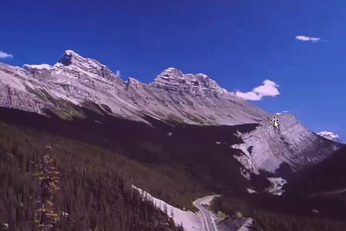
Columbia Icefields & Sunwapta Pass
The Columbia Icefields area provides additional examples of Front Range stratigraphy.
Important units visible include:
Palliser Formation.
Banff Formation.
Rundle Group.
Distinct differences in appearance occur between formations.
The Rundle Group often appears:
Jagged.
Rugged.
The Banff Formation is commonly:
Snow covered in photographs.
Less visually distinctive because of weathering and snow cover.
The Palliser Formation remains a major cliff former.
Together these units create many of the classic Rocky Mountain landscapes.

Frank Slide
The Frank Slide is one of the most famous geological events in Canadian history.
It occurred near:
Frank.
Crow's Nest Pass.
The slide was strongly influenced by geological structure.
Large faults and folds existed within the mountain.
These structures created planes of weakness.
Eventually:
The weakened rock mass failed.
A massive landslide occurred.
The failure followed structural weaknesses created during mountain building.
Therefore:
The slide is directly related to Rocky Mountain tectonics.
Without the major fault systems:
The failure would have been much less likely.
The Frank Slide serves as an example of how ancient geological structures can influence modern hazards.
Transition from Front Ranges to Main Ranges
Moving westward leads from the Front Ranges into the Main Ranges.
The character of the mountains changes noticeably.
Front Ranges are dominated by:
Steeply dipping strata.
Major thrust faults.
Strong structural deformation.
Main Ranges are characterized by:
Large isolated mountain masses.
More horizontal-appearing strata.
Castellated mountain shapes.
The transition marks a change in both:
Structure.
Landscape appearance.
Main Ranges
The Main Ranges contain some of the most iconic Rocky Mountain scenery.
These are characterized by large, isolated, castellated mountains, with predominantly Cambrian quartzite and carbonate units forming the prominent faces, separated by slope-forming shales.
Mountains often appear:
Massive.
Blocky.
Castle-like.
The term "castellated" is used to describe these mountains.
Castellated means:
Resembling a castle.
Having block-like towers and walls.
Many Main Range mountains consist of:
Cambrian quartzites.
Carbonate units.
The Gog Group is especially important.
Gog Group rocks commonly form:
Resistant cliffs.
Prominent mountain faces.
Role of Shales in Main Range Topography
Although resistant rocks form mountain peaks, softer rocks still play an important role.
Shales commonly occur between resistant units.
Because shales erode easily:
They form valleys.
They create low areas between mountains.
This creates the familiar Rocky Mountain pattern of:
High resistant peaks.
Lower eroded valleys.
Synclines in the Main Ranges
Many Main Range mountains represent preserved synclines.
A syncline is a fold that curves downward.
The instructor describes a syncline as resembling a:
Smiley face.
Originally:
Synclines were paired with anticlines.
Anticlines resembled frowny faces.
During erosion:
Large portions of the fold system were removed.
The edges were progressively stripped away.
Eventually:
Only the central portion of the syncline remained.
This preserved core appears relatively flat.
However:
The rock was originally folded.
The apparent flatness is an illusion created by erosion.

Mount Kerkeslin Example
Mount Kerkeslin is presented as a classic Main Range example.
The mountain preserves:
The core of a syncline.
The Gog Group is prominently exposed.
The structure demonstrates how erosion can isolate fold cores.
What remains today represents only a small portion of the original fold system.
Much of the surrounding structure has been removed.