LC Geography Sample Answers
Chapter 1: Plate Tectonics
“Describe and explain destructive plate boundaries” (30 marks)
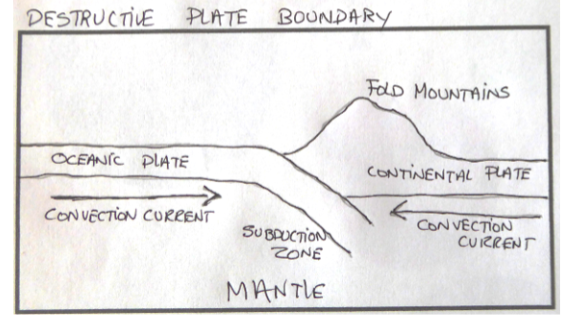
Convection currents moving through magma in the mantle causes plates to collide with each other at convergent plate boundaries.
When an oceanic plate collides with another plate (oceanic or continental) the heavier and denser of the two plates subducts under the light, less dense plate.
As convection currents drag the the plate downwards, an arc-shaped ocean trench is formed at the subduction zone.
Fluids (water) and gases (carbon dioxide and sulphur dioxide) are released from the crust, causing temperatures in the area to rapidly increase and the sinking crust to melt.
A silica and gas-rich magma formed from the destroyed crust burns a path through the overlying, lighter oceanic crust.
At the boundary where the Pacific and Eurasian oceanic plates collide, the explosive volcanic eruptions occur on the sea floor once the magma reaches the surface of the earth.
Over time a chain of volcanic islands known as an island arc forms parallel to the oceanic trench (e.g. the Japanese Islands).
Oceanic crust is also destroyed at the boundary where the Nazca oceanic plate and South American continental plate collide.
Over time, a chain of volcanic mountains form on the South American (continental plate), parallel to the subduction zone (Andes volcanic arc).
Rocks at the edges of the South American (continental plate) also buckle upwards, forming a range of fold mountains such as the Andes in South America.
Powerful earthquakes are also common at destructive plate boundaries as the rough edges of rocks at either side of the boundary can lock in position.
The last type of destructive plate boundary is where a continental plate collides with another continental plate (e.g. Eurasian and African plates).
No crust is destroyed, instead both plates buckle upwards forming fold mountains (e.g. the Alps).
Earthquakes are generated when convection currents eventually force the plates to move past one another very suddenly.
“Plate boundaries are places where land is both created and destroyed”. Examine this statement, with reference to examples you have studied. (30 marks)
Land is destroyed at destructive plate boundaries where an oceanic plate collides with another plate (oceanic or continental).
One example of a destructive plate boundary is where the Pacific and Eurasian plates collide.
Convection currents moving through magma in the mantle slowly carry the two plates causing them to collide (converge).
The heavier and denser Pacific Plate subducts under the lighter, less dense Eurasian Plate.
Fluids (water) and gases (carbon dioxide and sulphur dioxide) are released from the crustal part of the Nazca Plate as it sinks into the mantle.
Temperatures in the area rapidly increase and the sinking crust melts into a silica and gas-rich magma (land destroyed).
This magma burns a path through the overlying lighter, less dense Eurasian Plate.
Explosive volcanic eruptions occur on the sea floor forming a chain of volcanic islands (island arc) parallel to the subduction zone (e.g. the Japanese Islands).
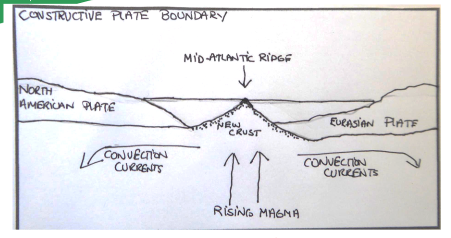
New land is created at constructive plate boundaries where currents in the magma cause oceanic plates to separate (diverge) and continental plates to split.
On example of land being created at a constructive plate boundary is the Mid-Atlantic Ridge.
Here, the North and South American plates are slowly separating from the Eurasian and African plates respectively.
As the plates separate, their crusts get thinner, and large cracks called fissures form along the boundary.
Magma rises to the surface to form a mid-ocean ridge, whose peaks rise above sea level creating volcanic islands such as Iceland.
The age of the rock on the sea floor is youngest along the boundary (Mid-Atlantic Ridge) and they get progressively older and deeper the further one moves from the point.
Chapter 2: Volcanoes
“Explain how the study of plate tectonics has helped us to understand the global distribution of volcanoes” (30 marks)
Plate tectonics is the term given to the process where convection currents in the mantle move the earth’s plates, causing them to separate (diverge), collide (converge) and slide past each other (transform) at plate boundaries.
Volcanic activity occurs at divergent (constructive) plate boundaries where 2 oceanic plates separate (e.g. Mid-Atlantic Ridge).
Magma rises to the surface through cracks (fissures) created on the sea-floor as the North and South American Plates slowly separate from the Eurasian and African plates respectively.
Volcanic activity also occurs where 2 continental plates separate (e.g. East African Rift Valley).
A rift valley is formed and the thinning of the crust also allows the formations of volcanoes (e.g. Mount Kilimanjaro).
Volcanoes are also found at destructive plate boundaries where plates collide.
When an oceanic plate is in collision with another plate (oceanic or continental), the heavier, denser of the two plates subducts into the mantle where its crust is melted.
Where the Pacific Plate (oceanic) subducts beneath the Eurasian plate (oceanic), the magma burns a path to the surface through the lighter crust where it forms a chain of volcanic island arc called the Japanese Islands.
Where the Nazca (oceanic) plate subducts beneath the South American Plate (continental), the magma burns a path through the lighter continental crust where it forms an arc of volcanic mountains called the Andes.
Finally, a volcanic island chain is formed at hotspots.
One example is the Hawaiian Island chain which is formed on the Pacific Plate.
Hotspots are regions of the earth’s mantle where the magma is hotter than the rest of the magma in the mantle surrounding it.
The hotspot is located at a fixed point in the mantle while the earth’s crustal plates move over it.
When a weak area of the Earth’s crust moves over the hotspot, plumes (columns) of hot magma will rise from the mantle to the surface forming volcanoes.
Over time, the volcano will become extinct as the Earth’s crustal plate continues moving, pushing it away from the hotspot.
This results in the volcanic mountains getting progressively older as one moves away from the hot spot.
“Describe and explain how humans interact with the rock cycle with reference to the following: Geothermal energy production” (30 marks)
One example of humans interacting with the rock cycle is the production of Geothermal energy by Iceland.
By the mid-20th century, Iceland was one of the poorest countries in Europe, relying on energy derived from imported coal and local peat to support the economy.
Threats to supply and the increasing cost of importing forced Icelanders to search for an alternative.
With the high concentration of volcanoes and hot springs due to its location on the Mid-Atlantic Ridge, Iceland had excellent advantages for the generation of geothermal energy.
Power stations use pipes to carry cold water deep underground where it’s superheated using the heat from volcanic rocks. When it returns as steam to the earth’s surface, it moves turbines connected to generators, producing electricity.
Magma close to the earth’s surface superheats nearby water which stays as a liquid due to the pressure of overlying rocks..
This hot water is piped directly to homes, commercial businesses and industries, satisfying their hot water and space heating needs.
Iceland is self=sufficient in food production, with crops such as tomatoes, cucumbers and green peppers grown in geothermal greenhouses. Geothermal energy heats the greenhouses, geothermal steam is used to boil and disinfect the soil, while electric lighting has created a year-round growing season.
Geothermally heated water is being used to create optimum temperatures for the growth of salmon, trout and arctic char in 20/70 Icelandic fish farms.
Low cost green electricity and a reliable transmission system has driven rapid industrial development over the last 25 years.
Three aluminium smelters located in Iceland use up to 70% of the geothermal energy produced in the country.
The data centre industry is rapidly growing.
Iceland’s most famous tourist destination, the Blue Lagoon, was formed in 1976 during operations at the nearby geothermal power plant. Over the years, people have seen the health benefits of bathing in its mineral-rich water and applying the silica mud to their skin.
Ambitious plans are in place to build the world’s largest underwater connector to allow Iceland to export clean geothermal electricity to the UK. The so-called “Icelink” will help the UK reach its renewable goals.
Researchers are also working on a method of using geothermal electricity to split hydrogen from water. The hydrogen fuel cells would then be used to power the country’s vehicles and fishing trawlers.

“Discuss the positive impacts of volcanic activity” (30 marks)
Volcanic soils are extremely fertile (2 marks). When it rains the ash and cinders are dissolved and carried down into the soil where they release their valuable minerals.
Lava also cools to form basalt, which also weathers into a mineral-rich, fertile soil.
As a result of this soils in these areas produce high crop yields.
Brazil is the world’s leading producer of coffee, a direct result of the productivity of its volcanic soils.
Larger outputs benefit the local economy enormously as farmers now have more than enough to produce to sell and bring in more money for themselves and for their local economies which allow developing economies to bring in much needed money for the country.
Today 7 major geothermal power plants produce low-cost emission free energy in Iceland.
Energy costs would be 5x higher and CO2 emissions would be up 40% greater if Icelanders were still dependent on fossil fuels for home heating instead of geothermal energy.
Geothermal heating meets all necessary heating and hot water needs for about 87% of the country including over 150 public swimming pools.
Iceland is self-sufficient in food production with crops such as tomatoes, cucumbers and green peppers grown in geothermal greenhouses.
Geothermal energy heats the greenhouses, geothermal steam boils and disinfects the soil, while electric lighting has created a year round growing season.
Geothermally heated water is being used to create optimum temperatures for the growth of salmon, trout and arctic char in 20/70 Icelandic fish farms.
Low-cost green electricity and a reliable transmission system has driven rapid industrial development over the last 25 years.
Three aluminium smelters use up to 70% of the geothermal energy produced in the country.
The data centre industry is rapidly growing with servers using large amounts of energy also benefitting from Iceland’s cool climate.