EAS 209 - Lecture 27
Review of Rocky Mountain Belt
Previously discussed the three formations commonly associated with the Front Ranges.
The Front Ranges triplet is:
Palliser Formation.
Banff Formation.
Rundle Formation.
A statement saying the triplet is Gog, Banff, and Palliser is false.
Main Ranges differ from Front Ranges in structural style.
Main Ranges commonly form the centers of large synclines.
Because they occupy synclinal centers, bedding is often less steeply dipping.
Erosion has removed portions of the folds, exposing rocks in the center of synclines.
Many mountains in the Main Ranges display relatively flat to gently dipping strata.
Examples shown:
Mount Victoria.
Mount Hoover.
Cathedral Mountain.
Mount Stephen.
Castle Mountain.
Cambrian strata are commonly exposed in these mountain cores.
The only belt with internal subdivisions; the other belts don’t have that.

ANS: False
(it would be Palliser, Banff, and then Rundle for the actual answer).
Western Ranges
Represent the westernmost subdivision of the Rocky Mountain Belt.
Characterized by a reversal in dip direction compared to previous ranges.
The dip reversal is an important structural change.
Age relationships and topography are not consistently related within this area.
Marks the transition toward the next major tectonic belt.
Rocky Mountain Trench
Forms the western boundary of the Western Ranges.
The western boundary of the Western Ranges is the Rocky Mountain Trench, a NW-SE feature that is 1800km long but of no particular structural origin.
To the west life the second belt, the Omineca Belt.
Serves as the boundary between:
Rocky Mountain Belt.
Omineca Belt.
Represents a major physiographic feature.
Appears as a broad, flat valley cutting through mountainous terrain.
Gives the impression of prairie-like terrain within the mountains.
Examples shown near:
Valemount.
Fairmont.
Contains glacial landforms and deposits.
Hoodoos occur within the trench.
Formed from glacial sediments.
Later eroded by wind and weathering.
Rock Types Associated with the Rocky Mountain Trench
Quartz monzonite:
Intrusive igneous rock.
Cooled slowly underground.
Contains large feldspar crystals.
Sphalerite-bearing limestone:
Formed when zinc-rich fluids moved through carbonate rocks.
Zinc precipitated as sphalerite.
Example from Invermere.

Omineca Belt
Second major tectonic belt west of the Rocky Mountains.
Rocks of this belt have a higher metamorphic grade [greenschist or low, to amphibolite or high] than rocks of the belts on either side.
Dominated by:
Metamorphic rocks.
Igneous intrusions.
Represents a fundamentally different tectonic environment than the Rocky Mountain Belt.
The western limit of the belt may be coincident with the old western limit to the craton.
Why is it high pressure but average temperature? Some people think it outlines the limit of the craton and significant zone of pressure that were sutured on on at a certain point in time. AaR, high pressure developed around those areas. But not completely solved.
The Omineca Belt comprises metasediments and metavolcanics, plus local granite bodies.
Meta as in “slightly altered”
It is associated with the Columbian Orogeny (120-100Mya)
Closely associated with the Columbian Orogeny.

Columbian orogeny formation ↑
Relationship to Major Mountain-Building Events
Two major mountain-building events affected western Canada:
Columbian Orogeny.
Laramide Orogeny.
Omineca Belt is primarily associated with the Columbian Orogeny.
Omineca and Coast Belts contain abundant:
Metamorphic rocks.
Igneous intrusive rocks.
Intermontane Belt lacks the same degree of metamorphism.
Rock types are one of the main criteria used to distinguish these tectonic belts.
Timing of Orogenies
Columbian Orogeny occurred first.
Laramide Orogeny occurred later.
Rocks formed during the Columbian Orogeny were later affected by the Laramide Orogeny.
The Laramide event overprinted older structures and rocks.
This means deformation from the younger event modified rocks that were already present.
Terrane Accretion and Growth of Western Canada
British Columbia formed through the gradual accretion of terranes.
Terranes are fragments of crust that collided with and attached to North America.
Older terranes are generally found farther east.
Younger terranes occur farther west.
The western margin of North America grew outward through time as more terranes were added.
Coastal regions were built progressively through repeated collisions and accretion.
Major Uplifts
Nelson Uplift.
Cassiar–Omineca Uplift.
These uplifts created elevated highland regions.
Their development altered marine circulation patterns.
Seaways were forced to bypass these uplifts.
Marine waters flowed north-south around them.
Cretaceous Seaway
During the Cretaceous, a major seaway extended through western North America.
The seaway stretched from northern regions southward.
Connected all the way to the Gulf of Mexico.
As terranes continued to accrete along the west coast:
Coastlines shifted westward.
Seaway geometry changed.
Metamorphism in the Omineca Belt
Metamorphic grade is significantly higher than in:
Rocky Mountain Belt (Foreland Belt).
Intermontane Belt.
Contains several important metamorphic facies.
Greenschist Facies
Forms under relatively low temperatures.
Forms under relatively low pressures.
Represents mild metamorphism.
Rocks are altered but not intensely metamorphosed.
Amphibolite Facies
Forms under higher temperatures.
Pressures remain relatively similar.
Indicates stronger metamorphic conditions.
Produces more extensive mineralogical changes.
Blueschist Facies
Forms under very high pressures.
Temperatures remain relatively moderate.
Indicates unusual tectonic conditions.
Often associated with subduction environments.
Significance of Blueschist Rocks
Their presence suggests intense compression.
May indicate the location of an ancient craton boundary.
Could represent major suture zones where terranes collided.
Suggests important tectonic events occurred in these regions.
Exact interpretation remains debated.
Continues to be an active area of geological research.
Rock Types in the Omineca Belt
Metasediments.
Metavolcanics.
Granitic intrusions.
Strongly associated with the Columbian Orogeny.
Columbian Orogeny occurred approximately 120–100 million years ago.
Model for the Columbian Orogeny
Initial Conditions (>120 Ma)
Continental margin bordered a basin.
Slide Mountain Ocean existed between terranes.
Quesnellia existed as an offshore island arc.
Active subduction occurred beneath the continental margin.
Progressive Collision
Continued subduction caused compression.
Ocean basin narrowed through time.
Terranes migrated toward the continent.
Slide Mountain Ocean gradually closed.
Crustal shortening increased.
Final Conditions (~100 Ma)
Quesnellia collided with North America.
Slide Mountain Ocean disappeared.
Terranes became attached to the continent.
Significant uplift occurred.
Mountain building intensified.
Portions of some terranes were destroyed by subduction.
Other portions were preserved and incorporated into the continent.
Characteristics of Omineca Belt Rocks
Rocks are commonly:
Folded.
Thrusted.
Metamorphosed.
Altered.
Unlike many Front Range rocks, they are not simply preserved sedimentary layers.
Deformation is much more intense.
Examples of Omineca Belt Rocks
Windermere Supergroup metaconglomerates.
Original conglomerates have been metamorphosed.
Clasts remain visible despite alteration.
Mount Nelson quartzite and dolomite.
Part of the Purcell Supergroup.
Exposed near Mount Nelson.
Granitic intrusions near Nelson, BC.
Represent intrusive igneous activity associated with mountain building.
Economic Geology of the Omineca Belt
Rich in mineral deposits.
Important mining district.
Contains:
Silver deposits.
Lead deposits.
Zinc deposits.
Mineralization commonly formed from hot hydrothermal fluids.
These fluids moved through fractures and deposited valuable minerals.
Silver-Lead Ore Deposits
Example shown east of Nelson.
Formed by hot mineral-rich fluids.
Produced economically important ore bodies.
Garnet and Hornblende Metamorphic Rocks
Garnet forms under relatively high-pressure conditions.
Garnet crystals are often well developed and visually striking.
Garnets commonly form dodecahedral crystal shapes.
Foliated mica-rich rocks are also common.
Micas produce shiny layers within the rock.
Hornblende appears as darker minerals between mica-rich layers.
Foliation records directed pressure during metamorphism.
Pegmatites and Kyanite
Pegmatites form under high temperatures and pressures.
Often contain unusually large crystals.
Can host rare minerals.
Kyanite:
Blue metamorphic mineral.
Forms elongated blade-shaped crystals.
Indicates significant metamorphism.
Commonly displayed in mineral collections because of its striking appearance.
Preservation of Original Sedimentary Features
Even after metamorphism, some original structures remain visible.
Cross-bedding can still be preserved.
Shows that metamorphism does not always completely erase original textures.
Example shown in rocks equivalent to the Purcell Supergroup.
Syntectonic Emplacement
Means intrusion occurred while tectonic deformation was actively happening.
Folding and emplacement happened simultaneously.
Associated with terrane accretion and mountain building.
Indicates magma intruded while crustal compression was occurring.
Asbestos and Serpentinite
Asbestos can form during metamorphism.
Commonly associated with serpentinite.
Serpentinite consists of serpentine minerals.
Asbestos minerals are fibrous.
Fibers separate into fine strands.
Properties of Asbestos
Historically used as insulation.
Fibrous texture made it useful for fire-resistant materials.
Fibers can break into microscopic airborne particles.
Inhalation is dangerous because fibers can damage lung tissue.
Safe to touch in solid form.
Dangerous primarily when fibers become airborne and are inhaled.
Terranes of the Omineca Region
Slide Mountain Terrane represents remnants of a former ocean basin.
Quesnellia represents an island-arc terrane.
These terranes preserve evidence of ancient tectonic environments.
Their relationships help reconstruct how western North America formed.
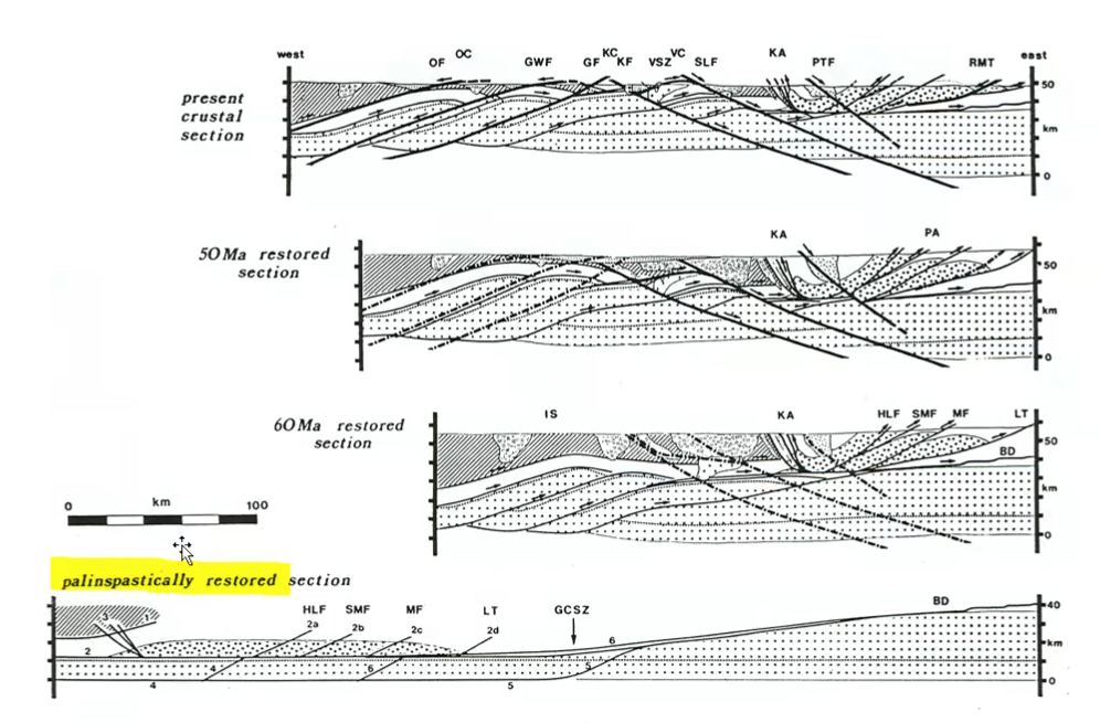
Palinspastic Reconstruction
Geologists use a technique called palinspastic reconstruction to understand how terranes were originally arranged before deformation.
Modern western North America is heavily:
Folded.
Faulted.
Thrusted.
Compressed.
These processes shortened and distorted the crust.
Palinspastic reconstruction attempts to reverse this deformation.
Where scientists take what’s all squished together and they try to stretch it back out to see how thick everything used to be + where everything was before.
Time consuming.
They stretched back all the folds and thrusts.
Very interesting metasediments in the Omineca belt: some of the Windermere group and the Purcell Supergroup are preserved in the Omineca Belt.
How It Works
Geologists measure:
Fault displacement.
Fold geometry.
Amount of crustal shortening.
They progressively "unfold" and "unstretch" the rocks.
This allows them to reconstruct ancient tectonic configurations.
The goal is to determine:
Original positions of terranes.
Original basin widths.
Original continental margins.
Ancient ocean locations.
Challenges
Extremely time-consuming process.
Requires large amounts of structural data.
Contains some degree of interpretation.
Different researchers may reconstruct slightly different models.
Computer modeling has made reconstruction easier than in the past.
Despite improvements, uncertainty still exists.
Results of Reconstruction
Modern compressed crust can be restored to a much wider original configuration.
Shows where continental crust originally existed.
Helps test models of terrane accretion.
Provides evidence supporting collision and accretion hypotheses.
One of the major methods used to validate tectonic models for western North America.
Summary of the Omineca Belt
Characterized by:
Metamorphic rocks.
Igneous intrusions.
Complex deformation.
Contains:
Folded rocks.
Thrust faults.
Metasediments.
Mineral deposits.
Strongly associated with the Columbian Orogeny.
Represents a major zone of crustal compression and terrane accretion.
Contains many economically important mineral deposits.
Preserves portions of:
Windermere Group.
Purcell Supergroup.
One of the most geologically complex regions in British Columbia.

Intermontane Belt
Located west of the Omineca Belt.
This belt is physiographically more subdued (i.e. lower elevation and lesser relief than bordering belts).
Nakinilerak Lake, central BC.
It exhibits very low grade metamorphic rocks, plus unmetamorphosed Upper Paleozoic to recent volcanics, sedimentary rocks, and granites.
Represents another major tectonic belt within British Columbia.
Comparatively less deformed than the Omineca Belt.
Similar in some ways to the Rocky Mountain Trench region because it contains broad areas of lower relief.
Generally less mountainous than adjacent belts.
General Characteristics
Relatively subdued topography.
Less intense deformation than the Omineca Belt.
Contains:
Low-grade metamorphic rocks.
Unmetamorphosed sedimentary rocks.
Volcanic rocks.
Granitic intrusions.
Preserves rocks ranging from the Paleozoic to more recent volcanic deposits.
Rock Types Present in Intermontane Belt
Low-grade metamorphic rocks.
Sedimentary rocks and granite.
i.e. Permian cache Creek Group).
Fusulinid Limestone
Volcanic rocks.
Granitic intrusions.
Upper Paleozoic strata.
Recent volcanic deposits.
Rhyolite Tuff
Tuff is a volcanic rock formed from volcanic ash.
Produced during explosive volcanic eruptions.
Rhyolite tuff indicates silica-rich volcanism.
Example shown from the Intermontane Belt.
Lignite
A low-grade coal. A crappy coal that hasn’t been heated or cooked enough.
Represents an early stage of coal formation.
Contains relatively low carbon content.
Has lower energy value than higher-rank coals.
Indicates organic material was buried but not subjected to enough heat and pressure to form higher-quality coal.
Volcanic Features: Columnar Basalt
Basalt commonly develops columnar jointing as it cools.
Cooling causes contraction.
Contraction produces fractures.
Fractures create large polygonal columns.
Similar to:
Devil's Causeway in Northern Ireland.
Example shown from Babine Lake, BC.

Characteristics of Columnar Basalt
Forms from cooling basaltic lava.
Produces vertical or inclined columns.
Columns can be several meters tall.
Represents a common volcanic cooling feature.
Indicates large basalt flows.
Permian Fusulinid Limestone
Found near Cache Creek.
Contains fusulinids.
Fusulinids
Microscopic marine organisms.
Type of foraminifera.
Often resemble grains of rice.
Lived in ancient marine environments.
Became extinct during the Permian.
Useful as index fossils for dating rocks.
Their presence confirms a Permian age.
Jurassic Fernie Group
Jurassic-aged sedimentary rocks.
Poorly exposed in Alberta because they weather easily.
Better exposures occur in British Columbia.
Ashcroft contains notable Fernie Group exposures.
Consists largely of shale.
Significance of Fernie Group
Preserves Jurassic environments.
Important for understanding Mesozoic geology.
Provides rare surface exposures of Jurassic strata.
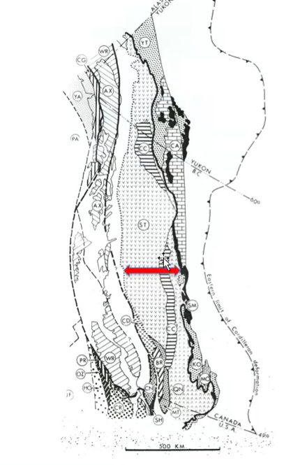
Terrane Compression Within the Intermontane Belt
Multiple terranes collided during accretion.
Examples include:
Stikinia.
Quesnellia.
Cache Creek Terrane.
As collisions continued:
Terranes were compressed.
Terranes were shortened.
Terranes became sandwiched together.
Stikinia and Quesnellia had more igneous and metamorphic rock times. Cache Creek Terrane was squished in between\.
Cache Creek Terrane
Occupies a position between neighboring terranes.
Experienced significant compression during accretion.
Became trapped between larger tectonic blocks.
Preserves evidence of ancient oceanic environments.
Stikinia
Contains:
Carboniferous limestones.
Volcanic rocks.
Represents another important accreted terrane.
Preserves evidence of ancient island-arc activity.
Copper Mineralization
Copper ore deposits occur within the Intermontane Belt.
Commonly associated with igneous intrusions.
Hydrothermal fluids transported dissolved metals.
Metals precipitated and formed ore deposits.
Example shown near Merritt, BC.
Summary of the Intermontane Belt
Less deformed than the Omineca Belt.
Contains both sedimentary and volcanic rocks.
Includes low-grade metamorphic rocks.
Preserves important terranes:
Stikinia.
Quesnellia.
Cache Creek.
Contains significant volcanic features.
Hosts economically important copper deposits.
Represents another major stage in the assembly of British Columbia.

Coast Plutonic Belt (Coastal Belt)
The Coast Plutonic Belt is primarily associated with the Laramide Orogeny.
Unlike the Omineca Belt, which is linked mainly to the Columbian Orogeny, the Coast Plutonic Belt represents major tectonic activity during the Laramide event.
The Laramide Orogeny overprinted many older rocks and structures that already existed.
Because it occurred later, its effects can be seen across multiple tectonic belts.
The Laramide Orogeny
One of the major mountain-building events affecting western North America.
Associated with:
Subduction.
Compression.
Magmatism.
Mountain building.
Still debated by geologists today.
Researchers agree that subduction occurred, but disagree on some details of exactly how the crust responded.

Competing Models for the Laramide Orogeny
Several hypotheses exist.
Examples include:
Retroarc thrusting.
Orogenic float tectonics.
Other subduction-related models.
All models involve subduction beneath North America.
Differences mainly concern:
Angle of subduction.
Length of the subducting slab.
Location of crustal shortening.
Style of deformation.
Why the Laramide Orogeny Is Difficult to Interpret
Rocks have been:
Folded.
Faulted.
Metamorphosed.
Eroded.
Terranes have been compressed together.
Some evidence has been destroyed through later tectonic activity.
Different parts of the west coast experienced deformation at different times.
This creates a complex geological record.
Timing of the Laramide Orogeny
Along the entire western margin of North America, timing varies.
In southern regions:
Activity began earlier.
Some effects date back to the Jurassic.
In British Columbia:
Main focus is approximately 50–65 million years ago.
Represents the latest stages of mountain building relevant to this course.
Occurred near the end of the Cretaceous and into the early Cenozoic.
One of the largest Phanerozoic intermediate igneous complexes in the world, with 3/4’s of the volume being plutonic (intrusive), mostly late Jurassic to Early Cretaceous in the south and younger in the north.
For our purposes, the Laramide orogeny was 50-65Mya.
Largest Intermediate Igneous Complexes
One result of the Laramide Orogeny was formation of enormous igneous complexes.
Coast Plutonic Belt contains one of the largest intermediate igneous complexes in the world.
"Intermediate" refers to magma composition.
Roughly three-quarters of the total volume is intrusive.
Indicates massive amounts of magma were generated and emplaced within the crust.
Northward Progression of Activity
Activity appears to have started earlier in southern regions.
Mountain building progressively migrated northward.
Southern British Columbia experienced deformation before northern areas.
Suggests tectonic activity spread along the continental margin through time.
Characteristics of the Coast Plutonic Belt
Dominated by:
Plutons.
Granitic rocks.
Metamorphic rocks.
Represents large volumes of magma that crystallized underground.
Contains some of the largest intrusive rock bodies in western North America.
Plutonic Suites
Plutons are large intrusive igneous bodies.
Form when magma cools slowly underground.
Slow cooling produces coarse crystals.
Large portions of the Coast Belt consist of exposed plutons.
Exposure occurred after erosion removed overlying rock.
Jurassic Metasediments
Sedimentary rocks within the belt have often been metamorphosed.
Original sedimentary features may still be recognizable.
Demonstrates that deformation affected both igneous and sedimentary rocks.
Syenite
Igneous rock similar to granite.
Contains less quartz than granite.
Still forms through slow cooling underground.
Common within plutonic environments.
Granitoid Gneiss
Originally granite.
Later subjected to metamorphism.
Developed foliation and banding.
Records both igneous and metamorphic histories.
Importance of Granitoid Gneiss
Indicates:
Magmatism occurred.
Later deformation affected the rock.
Provides evidence of multiple tectonic events.
Basalt Flows
Large basalt flows occur within the region.
Basalt is:
Extrusive.
Fine-grained.
Mafic.
Forms when lava erupts at the surface and cools rapidly.
Brecciated Lava
It was generated by east-dipping subduction, and terranes of the Intermontane Belt (east) and Insular Belt (west) can be traced to it.
This suggests that is obscures an ancient continental suture zone.
Contains broken angular fragments.
Indicates volcanic activity and mechanical disruption during or after eruption.
Often associated with active tectonic environments.
Evidence for Ancient Continental Sutures
Distribution of metamorphic rocks and igneous rocks suggests:
Continental fragments may have collided.
Ancient continental crust may have been sutured together.
Sutures mark former collision zones.
These zones preserve evidence of major tectonic events.
Deformation Within the Coast Belt
Rocks commonly show:
Folding.
Stretching.
Faulting.
Compression.
Reflects intense tectonic activity during mountain building.
Deformed Sedimentary Rocks
Examples include:
Sandstones.
Coal-bearing strata.
Originally deposited in sedimentary environments.
Later deformed by tectonic forces.
Copper Mineralization
Copper deposits occur throughout the Coast Belt.
Associated with:
Magma.
Hydrothermal fluids.
Fluids transported dissolved metals through fractures.
Copper precipitated as ore minerals.
Creates economically valuable deposits.
Relationship to Volcanism
Coast Belt was associated with extensive volcanic activity.
Presence of:
Granites.
Basalts.
Other igneous rocks.
Indicates long-lived magmatism.
Similar processes are still active along portions of the Pacific margin today.

Insular Belt
The eastern boundary of the Insular Belt is submerged in the straits between the Islands and the mainland, underlying the continental shelf and slope.
The boundary between the Coast Belt and the Insular Belt is submerged.
Located between:
Vancouver Island.
Mainland British Columbia.
Now occupied by marine waters.
Marks another major tectonic division within western Canada.
The westernmost tectonic belt of British Columbia.
Located west of the Coast Plutonic Belt.
Boundary between the Coast Belt and Insular Belt is submerged beneath the ocean.
Lies between:
Vancouver Island.
Mainland British Columbia.
Represents some of the youngest accreted crustal fragments along western Canada.

Modern Tectonic Activity Along the Coast
Active subduction continues today.
The western boundary is a plate boundary, either a subduction zone with Juan de Fuca Plate (red) or a transform boundary to the north of that (green).
Juan de Fuca Plate is being subducted beneath North America.
Subduction is responsible for:
Earthquakes.
Volcanism.
Mountain building.
Juan de Fuca Plate
Oceanic plate located off the west coast.
Moving beneath North America.
Generates ongoing tectonic activity.
Responsible for much of the seismic hazard in British Columbia.
Being subducted underneath the continent. Instead of straight subduction, there is sliding back and forth.
Things are being subducted at an angle.
Leads to some sliding occurring as well.
Creates a more complex tectonic setting.
Volcanic Belts Along the Coast
Numerous volcanoes occur along the western margin of North America.
Includes:
Cascadia volcanic arc.
Anahim volcanic belt.
Alaskan volcanic systems.
Most formed because of subduction-related magmatism.
Importance of Modern Volcanism
Provides evidence that tectonic processes responsible for ancient mountain building are still active.
Demonstrates that western North America remains a dynamic tectonic environment.
Modern subduction helps explain many of the ancient rock relationships preserved throughout British Columbia.
Modern Tectonic Setting
Modern tectonic activity helps explain how these belts originally formed.
Active subduction continues today along the west coast.
The Juan de Fuca Plate is currently being subducted beneath North America.
This ongoing subduction produces:
Earthquakes.
Volcanism.
Crustal deformation.
Mountain building.
Volcanoes Along Western North America
Numerous volcanoes occur along the Pacific margin.
Examples include:
Cascadia volcanoes.
Anahim Volcanic Belt.
Alaskan volcanoes.
Many ancient volcanic systems preserved in British Columbia formed through similar processes.
Most modern volcanism is linked directly to subduction.
Transform Motion in Northern Regions
Northern portions of the margin show transform motion.
Plates slide laterally past one another.
Motion is not purely convergent.
Creates a more complicated tectonic setting than simple subduction alone.

Big-Picture Evolution of Western North America
Geological diagrams summarize the evolution of western North America through time.
Time spans:
Neoproterozoic.
Paleozoic.
Mesozoic.
Cenozoic.
Diagrams show changes from east to west across the continent.
Continental Margin Evolution
Continental margins shifted repeatedly through geological time.
Sea level changes altered the position of coastlines.
Ancient oceans expanded and contracted.
Rodinia eventually broke apart.
Later, Pangaea formed and subsequently fragmented.
The Panthalassa Ocean occupied the western margin.
Panthalassa is the ancient ocean that later became the Pacific Ocean.
Development of Subduction
There is debate regarding exactly when subduction became dominant along the western margin.
By the Mesozoic:
Island arcs were present.
Terrane accretion was occurring.
Major tectonic collisions were underway.
Most of British Columbia was assembled during this interval.
Terrane Accretion
Island arcs and oceanic fragments collided with North America.
These terranes became welded onto the continent.
Successive collisions built western Canada outward.
Accretion is one of the most important geological processes responsible for modern British Columbia.
Wrangellia Terrane
One of the major accreted terranes of western North America.
Contains significant igneous rocks.
Includes both:
Igneous rocks.
Metamorphic rocks.
Provides evidence of a complex tectonic history.
Metamorphic Rocks in Wrangellia
Many rocks have been altered through metamorphism.
Original textures may be partially preserved.
Demonstrate that tectonic activity affected the terrane after formation.
Glacial Striations
Grooves carved into bedrock by moving glaciers.
Produced when rocks frozen into the base of a glacier scrape against underlying bedrock.
Result from:
Freeze-thaw cycle → causes scours and grooves as it moves along.
Rocks and sharp parts are frozen into the glacier, making marks onto the rocks they pass by.
Produces striations.
Abrasion during glacier movement.
Importance of Striations
Record glacier movement directions.
Geologists measure their orientations.
Used to reconstruct:
Ice flow directions.
Extent of glaciers.
Glacial history.

Butchart Gardens and Limestone Quarrying
Present-day Butchart Gardens was originally a limestone quarry.
Located on Vancouver Island.
Quarry exploited Upper Triassic limestone deposits.
Large quantities of limestone were removed.
After quarrying ceased:
The site was transformed into a famous garden.
Represents an example of geological resources being repurposed after extraction.
840 000 tonnes were quarried.
Upper Triassic Limestone
Occurs extensively on Vancouver Island.
Deposited in marine environments.
Important economic resource.
Quarried for industrial purposes.
Scale of Quarrying
More than 840,000 tons of limestone were extracted.
Quarry operated for approximately twenty years.
Demonstrates the economic importance of these deposits.
Upper Triassic Limestone on Vancouver Island
Extensive Upper Triassic limestone deposits occur on Vancouver Island.
These limestones formed in warm, shallow marine environments.
They are preserved within the Insular Belt.
Important both geologically and economically.
Quarried extensively for industrial use.
Example: Quatsino Formation.
Quatsino Formation
Upper Triassic limestone unit.
Widely exposed on Vancouver Island.
Represents marine carbonate deposition.
Indicates that much of the region was submerged beneath a shallow sea during the Late Triassic.
One of the better-known carbonate units in western Canada.
Cretaceous Sandstones
Preserved near Courtenay, Vancouver Island.
Deposited during the Cretaceous Period.
Represent sediment accumulation after many terranes had already accreted.
Provide evidence of changing depositional environments through time.
Coal Deposits on Vancouver Island
Coal occurs within some of the Cretaceous sedimentary rocks.
Coal mining became an important industry on Vancouver Island.
Mining continued until approximately the mid-1900s.
Coal formed from accumulated plant material that was buried and preserved.
Indicates the presence of swampy, vegetation-rich environments during deposition.
Eocene Igneous Activity
Igneous rocks from the Eocene are preserved within the Insular Belt.
Eocene rocks are relatively young compared to many of the other rocks discussed in the course.
Demonstrate that igneous activity continued long after the major Mesozoic terrane accretion events.
Provide evidence that western North America remained tectonically active into the Cenozoic.
Basalt
Basalt is an extrusive igneous rock.
Forms when lava erupts onto the surface and cools rapidly.
Fine-grained due to rapid cooling.
Common in volcanic regions.
Pillow Basalts
Form when basalt erupts underwater.
Rapid cooling against water creates rounded, pillow-like structures.
Important indicator of submarine volcanic activity.
Evidence that volcanic eruptions occurred beneath ancient oceans or seas.
Useful for reconstructing past environments.
Gabbro
Intrusive equivalent of basalt.
Forms from the same type of magma.
Cools slowly underground.
Coarse-grained because crystals have time to grow.
Indicates intrusive magmatic activity beneath volcanic systems.
San Juan Fault
Important fault zone in the Insular Belt.
Relatively recent.
Associated with relatively recent tectonic activity.
Provides evidence of continued crustal deformation after terrane accretion.
Fault Gouge
Forms along the center of active fault zones.
Produced when rocks grind against each other during fault movement.
Rock becomes crushed and pulverized.
Creates a soft, clay-like material.
Indicates significant fault displacement and friction.
Turbidites
Deposits formed by turbidity currents.
Turbidity currents are underwater sediment avalanches.
Occur when unstable sediment on continental slopes collapses and flows downslope.
Carry large amounts of sediment into deeper water.
Characteristics of Turbidites
Commonly show graded bedding.
Coarser material settles first.
Finer sediment settles later.
Produce distinctive sedimentary sequences.
Important indicators of deep-marine depositional environments.
135 Million-Year-Old Turbidites
Preserved within the Insular Belt.
Consist largely of:
Greywacke.
Argillite.
Provide evidence of ancient deep-water sedimentation.
Greywacke
Type of sandstone.
Contains abundant rock fragments.
Contains some feldspar.
Often associated with tectonically active environments.
Common in submarine fan deposits.
Argillite
Metamorphosed or lithified mudstone.
Fine-grained sedimentary rock.
Represents deposition of very fine sediment.
Often occurs alongside greywacke within turbidite sequences.
Folding and Metamorphism of Turbidites
Turbidite sequences have been:
Folded.
Compressed.
Metamorphosed.
Demonstrates that tectonic activity continued after deposition.
Provides evidence of later deformation associated with terrane accretion and mountain building.
Juxtaposition of Different Rock Units
Different rock packages have been pushed against one another through tectonic processes.
Shallow marine sediments may occur directly beside deeper marine deposits.
These unusual relationships result from faulting and terrane collision rather than normal sedimentation.
Relative Age Relationships
Fragments of older rocks incorporated into younger rocks indicate age relationships.
If a rock contains pieces of another rock:
The fragments must be older.
The host rock must be younger.
This is known as the Principle of Inclusions.
Used extensively in geological interpretation.

Leech River Formation
Example of an older rock unit.
Fragments incorporated into younger sedimentary rocks.
Demonstrates relative dating principles.
Helps establish the sequence of geological events.
Sooke Formation
Younger unit associated with some of the sedimentary successions discussed.
Contains sediments deposited after formation of older underlying units.
Rhodonite
Attractive pink manganese-rich mineral.
Commonly associated with metamorphic environments.
Forms under metamorphic conditions.
Often collected as a decorative mineral because of its striking colour.
Importance of Igneous and Metamorphic Minerals
Many minerals formed during metamorphism and igneous activity are visually spectacular.
Examples discussed include:
Garnet.
Kyanite.
Rhodonite.
These minerals are one reason many geologists are drawn to studying igneous and metamorphic rocks.
Overall Summary of British Columbia's Geological Development
British Columbia formed through repeated terrane accretion.
Multiple mountain-building events shaped the region.
The two major orogenies discussed were:
Columbian Orogeny.
Laramide Orogeny.
Terranes collided with North America and became permanently attached.
Subduction played a central role throughout development.
Compression produced:
Folding.
Faulting.
Metamorphism.
Mountain building.
Igneous activity generated:
Granites.
Basalts.
Large plutonic complexes.
Glaciation later modified the landscape through erosion and deposition.
Together, these processes produced the modern geology of British Columbia.
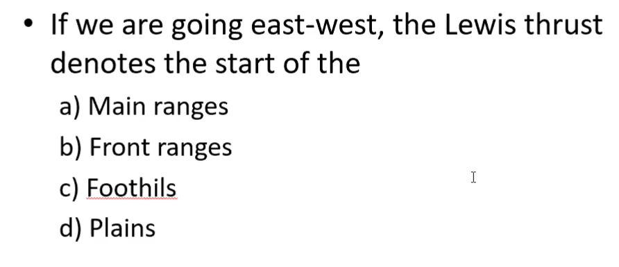
ANS: B

ANS: True.
The Omineca belt is associated with the Columbian orogeny. The Coast Pluton Belt is associated with the Laramide Orogeny.