Geo
The Theory of Continental Drift was proposed by Alfred Wegener in 1912.
🌍 What it says:
The continents were once joined together in one huge landmass called Pangaea. Over millions of years, this supercontinent broke apart, and the continents slowly drifted to their present positions.
Evidence Wegener used:
🧩 The coastlines of continents like South America and Africa seem to fit together like puzzle pieces.
🦕 Similar fossils of plants and animals are found on continents now separated by oceans.
🪨 Matching rock formations and mountain ranges are found on different continents.
❄ Evidence of ancient glaciers was found in places that are now warm.
Importance
The theory helped scientists understand how Earth's surface changes over time and later led to the development of the modern theory of plate tectonics.
continental crust
Crust
oceanic crust
upper mantle
Mantle
lower mantle
outer core
Core
inner core
Plate Movement
Plate movement is the slow movement of large pieces of Earth's crust, called tectonic plates. These plates float on the hot, semi-molten mantle beneath them.
Types of Plate Movement
Divergent Boundary ↔
Plates move away from each other.
New crust is formed.
Example: Mid-ocean ridges.
Convergent Boundary ➡⬅
Plates move toward each other.
Can form mountains, volcanoes, or deep ocean trenches.
Transform Boundary ⬆⬇
Plates slide past each other.
Often causes earthquakes.
What causes plate movement?
🔥 Heat from Earth's mantle creates convection currents that slowly move the tectonic plates.
🌍 SIAL and SIMA
These are older terms used to describe the composition of Earth's crust.
SIAL 🪨
Made mainly of Silica (Si) and Aluminium (Al).
Forms most of the continental crust (the land masses).
Lighter and less dense than SIMA.
SIMA 🌋
Made mainly of Silica (Si) and Magnesium (Ma).
Forms most of the oceanic crust (the ocean floor).
Heavier and denser than SIAL.
.
🌍 Earthquake
A sudden shaking of the Earth's crust caused by the release of energy when rocks break or move along faults.
🌋 Hypocenter (Focus)
The point inside the Earth where an earthquake begins and energy is first released.
🎯 Focus
Another name for the hypocenter.
📍 Epicenter
The point on the Earth's surface directly above the hypocenter (focus). This is often where the strongest shaking is felt.
⚠ Foreshock
A smaller earthquake that occurs before the main earthquake in the same area.
🌋 Volcano
An opening in the Earth's crust through which magma, ash, and gases escape to the surface.
🌴 Volcanic Islands in the Caribbean
Some Caribbean islands with volcanoes include:
Saint Vincent and the Grenadines
Dominica
Montserrat
Saint Lucia
Martinique
🌋 Lava Flow
Molten rock that erupts from a volcano and flows across the Earth's surface.
🌋 Tephra (sometimes spelled "tefra" or mistaken as "terrafa")
Rock fragments, ash, and other materials thrown into the air during a volcanic eruption.
🌊 Tsunami
A series of large ocean waves caused by underwater earthquakes, volcanic eruptions, or landslides.
🌫 Volcanic Ash
Tiny particles of rock, minerals, and volcanic glass ejected during an eruption.
💨 Volcanic Gas
Gases released from a volcano, including water vapor, carbon dioxide, and sulfur dioxide.
🔥 Pyroclastic Flow
A fast-moving, extremely hot mixture of ash, gas, and rock fragments that rushes down the sides of a volcano.
🌧 Lahar
A mudflow made of water, volcanic ash, and rock debris that flows down a volcano's slopes.
🌱 Caring for the Environment
Caring for the environment means protecting and preserving the natural world so that plants, animals, and people can live in a healthy and safe environment.
Ways to Care for the Environment
♻ Reduce, Reuse, and Recycle waste.
🚯 Do not litter; dispose of garbage properly.
🌳 Plant trees and protect forests.
💧 Conserve water by avoiding waste.
⚡ Save energy by turning off lights and appliances when not in use.
🚶 Walk, cycle, or use public transportation when possible.
🐢 Protect wildlife and their habitats.
🛍 Use reusable bags, bottles, and containers instead of single-use plastics.
Importance
Keeps air and water clean.
Protects plants and animals.
Reduces pollution.
Helps fight climate change.
👥 Population
The total number of people living in a particular area at a given time.
👨👩👧👦 Population Growth
The increase in the number of people living in an area over time due to births and immigration being greater than deaths and emigration.
🏘 Population Density
The number of people living in a given unit of land area, usually measured as people per square kilometre.
🗺 Population Distribution
The way people are spread out across an area, country, or region. Some places may be densely populated while others have few people.
NUMBER OF PEOPLE /AREA OF LAND
UNIT=PEOPLE PER KM2
👶 Birth Rate
The number of live births per 1,000 people in a population each year.
🎂 Life Expectancy
The average number of years a person is expected to live.
🍼 Infant Mortality
The number of babies who die before reaching one year of age per 1,000 live births in a year.
👧 Child Mortality
The number of children who die before reaching a specified age (often age 5) per 1,000 live births.
⚰ Death Rate
The number of deaths per 1,000 people in a population each year.
📈📉 Natural Change (Natural Increase/Decrease)
The difference between the birth rate and the death rate of a population.
If birth rate > death rate, the population increases.
If death rate > birth rate, the population decreases.
📊 Demographic Transition Model (DTM)
The Demographic Transition Model shows how a country's population changes over time as it develops economically and socially.
Stage 1: High Stationary
High birth rate 👶
High death rate ⚰
Population growth is very slow
Stage 2: Early Expanding
High birth rate 👶
Death rate falls due to better healthcare, food, and sanitation 🏥
Population grows rapidly 📈
Stage 3: Late Expanding
Birth rate begins to fall 👶⬇
Death rate remains low ⚰⬇
Population continues to grow, but more slowly
Stage 4: Low Stationary
Low birth rate 👶⬇
Low death rate ⚰⬇
Population growth is stable
Stage 5: Declining (in some versions)
Very low birth rate 👶⬇
Low death rate ⚰
Population may begin to decrease 📉
Purpose
The model helps explain:
Population growth
Changes in birth and death rates
How populations change as countries developer
Migration
Migration is the movement of people from one place to another to live temporarily or permanently.
Types of Migration
🏠 Internal Migration
Movement of people within the same country.
Example: Moving from May Pen to Kingston.
🌎 International Migration
Movement of people from one country to another.
Example: Moving from Jamaica to Canada.
😊 Voluntary Migration
When people choose to move for reasons such as work, education, or a better quality of life.
⚠ Forced Migration
When people are compelled to move because of war, natural disasters, persecution, or other dangers.
🔄 Return Migration
When people move back to their place or country of origin after living elsewhere.
Immigration and Emigration
📥 ImmigrationMoving into a country to live.
Example: A person moving to Jamaica from another country.
📤 Emigration
Moving out of a country to live elsewhere.
Example: A Jamaican moving to another country.
🌍 Net Migration
The difference between the number of immigrants and emigrants.
Net Migration = Immigration − Emigration
Positive net migration means more people enter than leave.
Negative net migration means more people leave than enter.
Push and Pull Factors
Push Factors (reasons people leave a place)
❌ Unemployment or lack of jobs
⚔ War, crime, or political instability
🌪 Natural disasters such as hurricanes, droughts, or floods
Pull Factors (reasons people move to a place)
💼 Better job opportunities
🏥 Better healthcare and education
🏡 Better living conditions and safety
🏘 Settlement
A settlement is a place where people live and establish homes, such as a village, town, or city.
Types of Settlement
🏠 Nucleated Settlement
Houses and buildings are grouped closely together.
Often found around a central feature such as a market, church, school, or water source.
🌾 Dispersed Settlement
Houses are spread out over a large area.
Common in rural and farming regions.
🛣 Linear Settlement
Houses and buildings are arranged in a line.
Usually develop along roads, rivers, railways, or coastlines.
🗺 Grid Reference
A grid reference is a set of numbers used to find an exact location on a map.
📍 Four-Figure Grid Reference
A four-figure grid reference identifies a square on a map.
Rule:
👉 Read across first (Eastings), then up (Northings).
How to Locate a Four-Figure Grid Reference
For example, 3467:
Find 34 on the bottom or top of the map (Eastings).
Move across to grid line 34.
Find 67 on the side of the map (Northings).
Move up to grid line 67.
The square where they meet is grid reference 3467.
📝 Remember: "Along the corridor, then up the stairs."
Along = Eastings
Up = Northings
🌊 Coastline
A coastline is the boundary where the land meets the sea.
How to Locate Features Using the Coastline
Find the coastline on the map.
Identify whether the feature is:
On the coast
Inland (away from the coast)
Offshore (in the sea)
Use nearby grid lines and grid references to determine the feature's location accurately.
Example:
If a lighthouse is beside the coastline within grid square 4572, its four-figure grid reference is 4572.
🌍 Key Point:
For grid references, always read eastings first, then northings. This helps you locate places accurately on a map. 🗺📍
🗺 Six-Figure Grid Reference
A six-figure grid reference gives a more exact location on a map than a four-figure grid reference.
How to Find a Six-Figure Grid Reference
Find the four-figure grid reference of the square.
Estimate how many tenths across the square the feature is.
Estimate how many tenths up the square the feature is.
Add these two extra digits to the four-figure grid reference.
Example
Suppose a feature is in grid square 3467:
It is 5 tenths across from grid line 34.
It is 8 tenths up from grid line 67.
The six-figure grid reference is 345678.
Rule
📍 Read across first (Eastings), then up (Northings).
Easy Reminder
🏃 "Along the corridor, then up the stairs."
First 3 digits = Eastings
Last 3 digits = Northings
Example References
Four-figure: 3467 (a grid square)
Six-figure: 345678 (a precise point inside the square)
Economic Activities
Economic activities are the jobs and actions people do to produce goods and provide services to earn income.
Categories of Economic Activities
🌾 Primary Economic Activities
Involve the extraction of raw materials from the Earth.
Examples:
Farming
Fishing
Mining
Forestry
🏭 Secondary Economic Activities
Involve processing raw materials into finished goods.
Examples:
Manufacturing
Food processing
Construction
🛒 Tertiary Economic Activities
Involve providing services rather than producing goods.
Examples:
Teaching
Banking
Transportation
Tourism
💻 Quaternary Economic Activities
Involve knowledge, information, and technology-based services.
Examples:
Research
Information Technology (IT)
Software development
Scientific work
🔄 Trading
The buying and selling of goods and services.
Important Terms
🌽 Self-Sufficient
Able to produce enough goods or food to meet one's own needs without outside help.
📦 Surplus
An amount that is more than what is needed.
Example: A farmer grows more crops than the family can consume.
📉 Deficit
An amount that is less than what is needed.
Example: A country does not produce enough food and must import some.
🌍 Resources
Resources are things that people use to satisfy their needs and wants.
Types of Resources
🌳 Natural Resources
Found in nature.
Examples: water, forests, minerals, soil, sunlight, and air.
👷 Human Resources
The skills, knowledge, and labour provided by people.
Examples: teachers, doctors, farmers, and builders.
🏭 Capital Resources
Man-made items used to produce goods and services.
Examples: machines, tools, factories, and vehicles.
💰 Financial Resources
Money used to start or run businesses and projects.
Renewable and Non-Renewable Resources
♻ Renewable Resources
Can be replaced naturally in a short time.
Examples: sunlight, wind, water, and forests (if managed properly).
⛽ Non-Renewable Resources
Cannot be replaced quickly once used up.
Examples: oil, coal, natural gas, and many minerals.
🌦 Weather
Weather is the day-to-day condition of the atmosphere at a particular place and time. It can change from hour to hour or day to day.
🌍 Climate
Climate is the average weather conditions of a place over a long period of time (usually 30 years or more).
Major Difference Between Weather and Climate
Weather | Climate |
|---|---|
Short-term atmospheric conditions | Long-term average weather conditions |
Changes frequently | Changes very slowly |
Measured daily | Studied over many years |
Six Elements of Weather and Their Instruments
Element of Weather | Instrument Used |
|---|---|
Temperature 🌡 | Thermometer |
Rainfall 🌧 | Rain Gauge |
Wind Speed 💨 | Anemometer |
Wind Direction 🧭 | Wind Vane |
Air Pressure 🌬 | Barometer |
Humidity 💧 | Hygrometer |
📝 Quick Definitions
Weather = The condition of the atmosphere at a specific time and place.
Climate = The average weather of a place over many years. 🌎☀🌧
💧 Hydrological Cycle (Water Cycle)
The hydrological cycle is the continuous movement of water between the Earth's surface, atmosphere, and underground.
Distribution of Earth's Water
The Earth is covered by about 70% water.
mm
Approximate Percentage | |
|---|---|
Oceans 🌊 | 97% |
Ice caps and glaciers ❄ | 2.9% |
Groundwater 💧 | 0.6% |
Lakes and rivers 🏞 | 0.1% |
Atmosphere ☁ | 0.001% |

Main Processes in the Hydrological Cycle
☀ Evaporation
The Sun heats water, causing it to change from liquid to water vapour.
☁ Condensation
Water vapour cools and changes into tiny water droplets, forming clouds.
🌧 Precipitation
Water falls from clouds as rain, snow, sleet, or hail.
Other Processes
🌿 Interception
Rainfall caught by leaves, branches, and vegetation before reaching the ground.
🌳 Stem Flow
Water flowing down the stems and trunks of plants and trees.
⬇ Infiltration
Water soaking into the soil from the surface.
⬇💧 Percolation
Water moving downward through soil and rock layers.
➡ Through Flow
Water moving sideways through the soil toward a river.
🏃 Surface Runoff
Water flowing over the land surface into rivers and streams.
🏞 Channel Flow
Water flowing within a river channel.
💦 Groundwater
Water stored beneath the Earth's surface in soil and rocks.
➡💧 Groundwater Flow
The movement of groundwater through underground rocks and soil.
🪨 Aquifer
A layer of rock or sediment that stores and allows groundwater to flow.
River Terms
🏞 River
A natural stream of flowing water moving towards a lake, sea, or another river.
🌄 Source
The place where a river begins.
🌊 Mouth
The place where a river enters a larger body of water such as a sea, lake, or ocean.
🌿 Tributary
A smaller river or stream that flows into a larger river.
🤝 Confluence
The point where two rivers or streams meet.
🏞 Main River
The largest river within a drainage basin.
🌧 Drainage Basin
The area of land drained by a river and its tributaries.
Quick Summary
Term | Meaning |
|---|---|
Evaporation | Water changes to vapour |
Condensation | Vapour forms clouds |
Precipitation | Water falls from clouds |
Interception | Rain caught by vegetation |
Infiltration | Water enters soil |
Percolation | Water moves through soil and rock |
Through Flow | Water moves sideways in soil |
Surface Runoff | Water flows over land |
Channel Flow | Water flows in a river |
Groundwater | Water stored underground |
Groundwater Flow | Underground water movement |
Aquifer | Rock layer storing groundwater |
Source | Beginning of a river |
Mouth | End of a river |
Tributary | Smaller river joining a larger river |
Confluence | Point where rivers meet |
Drainage Basin | Land drained by a river system |
💧🌍 The hydrological cycle ensures that water is constantly recycled and available for life on Earth.
The Rock Cycle 🌍🪨
The rock cycle is the continuous process by which rocks are formed, broken down, and changed into different types of rocks over time.
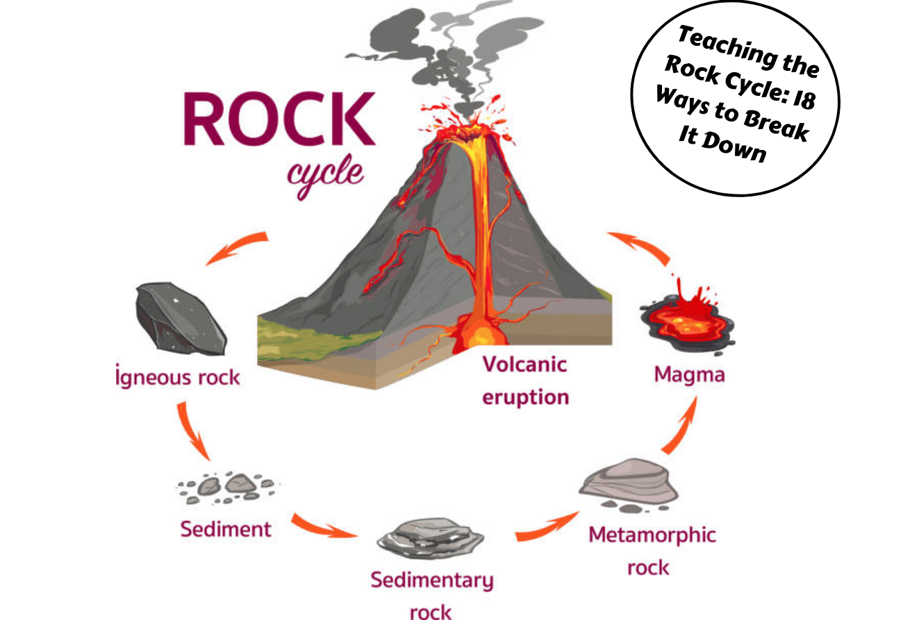
Types of Rocks
Igneous Rocks
Form when molten rock (magma or lava) cools and hardens.
Examples: Granite, Basalt
Sedimentary Rocks
Form when sediments are deposited, compacted, and cemented together.
Examples: Sandstone, Limestone
Metamorphic Rocks
Form when existing rocks are changed by heat and pressure.
Examples: Marble, Slate
Steps in the Rock Cycle
Magma cools → forms Igneous Rock
Weathering and erosion break rocks into sediments.
Compaction and cementation of sediments → forms Sedimentary Rock
Heat and pressure change rocks → forms Metamorphic Rock
Melting turns rocks back into magma.
The cycle repeats.
Simple Flow Chart
Magma → Igneous Rock → Sediments → Sedimentary Rock → Metamorphic Rock → Magma
Key Terms
Weathering: Breaking down of rocks.
Erosion: Movement of rock particles.
Compaction: Pressing sediments together.
Cementation: Gluing sediments together.
Melting: Rocks become magma.
Cooling: Magma becomes rock.
Summary: The rock cycle shows how igneous, sedimentary, and metamorphic rocks continuously change from one form to another through weathering, erosion, heat, pressure, melting, and cooling. 🌎✨
Map work is the skill of reading and interpreting maps to find information about places and features on the Earth's surface.
Common topics in map work include:
Directions 🧭 – North, South, East, and West.
Scale 📏 – Used to calculate actual distances.
Grid references 🔢 – Used to locate places on a map.
Contour lines ⛰ – Show the height and shape of the land.
Symbols and keys 🔑 – Explain what different signs on the map represent.
Latitude and longitude 🌍 – Used to determine exact locations.
Distance and area 📍 – Measuring how far apart places are.
Relief and drainage 🌊 – Identifying mountains, valleys, rivers, and other physical features.