EAS 209 - Lecture 32
Review of Previous Lecture: Colorado Group
Previous lecture discussed the Colorado Group.
Represents approximately 800 m of shale deposition.
Deposited when the Western Interior Seaway connected:
Gulf of Mexico.
Boreal Sea.
Nearly one kilometer of shale accumulated during this interval.

Completion of the Sloss Sequence Framework
Course has progressed through the entire Sloss sequence framework.
Covered geology from the Precambrian onward.
Today's lecture focuses only on the very top of the record.
Major Tejas deposits are largely absent in Alberta.
Only small remnants are preserved locally.
Focus shifts to:
Tertiary deposits.
Quaternary glaciation.
Tertiary Period:
Tertiary period began with the demise of the non-avian dinosaurs in the Cretaceous-Tertiary extinction event (called the KT boundary).
In terms of climate, the period was marked by widespread cooling, beginning in the Paleocene with tropical-to-moderate worldwide temperatures and ending before the first extensive glaciation at the start of the Quaternary. Although there was the Eocene Thermal Maximum (Ypression).
Mammals replaced reptiles as the dominant vertebrates on the planet.
Modern types of birds, reptiles, amphibians, fish, and invertebrates became numerous at the beginning of this period. Whales too!.
Modern types families of flowering plants evolved.
The earliest recognizable hominid relatives of humans appeared.
Begins after the end-Cretaceous extinction.
Cretaceous ended with:
Chicxulub impact event.
Dinosaur extinction.
Major ecological disruption.
Mammals diversified afterward and became dominant.
KT Boundary
KT boundary = Cretaceous–Tertiary boundary.
"K" used instead of "C" because several geological periods begin with C.
Marks:
End of dinosaurs.
Beginning of mammal-dominated ecosystems.
Tertiary Climate Evolution
Early Tertiary climate remained relatively warm.
Paleocene:
Tropical to temperate conditions.
Eocene:
Experienced the Eocene Thermal Maximum.
One of the warmest intervals of the Cenozoic.
Following Eocene:
Long-term cooling trend.
Development of polar ice.
Expansion of glaciers.
Last ~10,000 years represent recovery from glaciation.
Modern climate remains cooler than:
Cretaceous climates.
Early Paleogene climates.
Evidence for Ancient Warm Climates
Fossil forests preserved:
Antarctica.
High Arctic.
Presence of trees in these regions indicates:
Much warmer global temperatures.
Absence of permanent polar ice during those times.

Major Tertiary Epochs
Paleocene.
Eocene.
Oligocene.
Miocene.
Pliocene.
Pleistocene follows later in the Quaternary.
Important to know all of these.
Evolutionary and Tectonic Events Through the Tertiary
Paleocene
Rodents appear.
Early primates appear.
Atlantic Ocean continues development.
Eocene
Eocene Thermal Maximum occurs.
Bats appear.
Early whales appear.
Early horse ancestors (Eohippus) appear.
Europe and North America separate further.
Oligocene
Australia separates from Antarctica.
India collides with Asia.
Himalayas begin forming.
Antarctic glaciation begins.
Dogs, cats, and pigs appear.
Miocene
Africa moves toward Europe.
Alps continue developing.
Arctic ice expands.
Horses diversify.
Beavers appear.
Apes diversify.
Pliocene
Mediterranean Sea develops further.
North and South America connect via Panama.
Modern continental arrangement becomes established.
Earliest humans begin appearing.
Whale Evolution
Fossil whale skeletons discovered during sedimentological fieldwork in Africa.
Whales are interpreted to have evolved from land-dwelling ancestors.
Evolutionary sequence:
Terrestrial mammal.
Semi-aquatic lifestyle.
Fully aquatic whale.
Represents movement from land back into the ocean.
In the tertiary they went back into the water → whale formation.

Eocene Fossil Forests of the Arctic (Axel Heiberg)
Located on Axel Heiberg Island.
Dated to approximately 50 million years ago.
Preserved tree trunks found far north of modern tree line.
Forests existed during the Eocene Thermal Maximum.
Demonstrates:
Warm Arctic climate.
Major climate differences from today.
The thermal maximum occurred right at the start of the Eocene (Ypression).
Dating Limitation
Carbon dating cannot be used on Eocene fossils.
Fossils are too old for radiocarbon methods.
Alternative dating techniques are required.
Tertiary Deposits in Alberta
Deposits formed within the foreland basin.
Basin created by loading from Rocky Mountain uplift.
Weight of mountains depressed the crust.
Depression filled with sediment.

Preserved Tertiary Units
Rocky Mountains/Foothills
Porcupine Hills Formation.
Willow Creek Formation.
Plains Region
Paskapoo Formation.
Major aquifer unit.
Contains important groundwater reservoirs.
Contains coal deposits.
Source of significant surface coal mining.
Obed Coal Zone
Part of the Paskapoo Formation.
Located near Obed Mountain.
Obed Mountain lies along Highway 16 between Edmonton and Jasper.
Area known for coal resources.
Preservation of Tertiary Deposits
Much of Alberta's Tertiary record was removed by glacial erosion.
Best-preserved sections occur in elevated regions:
Cypress Hills.
Swan Hills.
Caribou Mountains.
Birch Mountains.
These areas preserve more complete successions than lower regions.
Everything else has been eroded by glaciers.
Tertiary Alberta: this part of the succession is a thin to thick veneer of continental, largely alluvial plain sediments; much is stripped by erosion… 10 isolated plateaus.
Examples include Swan Hills and Cyprus Hills.
Sediments were also deposited in valleys and troughs of the Rockies, but most are eroded now.
Excellent discoveries of Tertiary vertebrates/mammals occur, especially in the Cypress Hills region, with over 100 species known.
Counterintuitive Preservation Pattern
High elevations preserve older deposits.
Lower areas were preferentially eroded.
Opposite of the common expectation that older rocks occur only at depth.
Tertiary Fossils in Alberta
Pembina River
Excellent location for collecting fossil plants.
Fossil leaves preserved in gray mudstones.
Preservation quality often exceptional.
No permit required for casual collecting.
Other Local Fossils
Shells.
Plant remains.
Mammals.
Fish.
Turtles.
Ants.
Primates.
Blackmud Creek
Dinosaur fossils excavated close to the modern surface.
Fossil beds found with minimal excavation.
Dry Island Buffalo Jump Provincial Park
Excellent exposure of Paskapoo Formation.
Shows sandstone units and coal-bearing strata.
Modern river erosion exposes the formations.
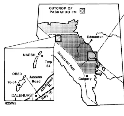
Coal Mining
Large-scale mining occurred in Paskapoo deposits.
Obed area especially important.
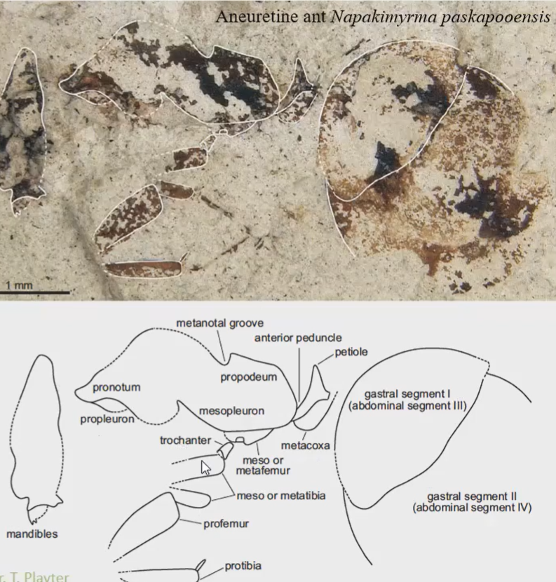
Fossil Ant Discovery
Fossil ant discovered in Tertiary deposits.
Preserved body structures include:
Mandibles.
Legs.
Abdomen.

Fossil Turtles
Found near Calgary and Red Deer.
Shells usually fragment during burial and compaction.
Fossils often occur as scattered shell fragments.
Fossil Fish
Well-preserved fish fossils known from deposits of similar age.
Fine-grained sediments allow exceptional preservation.
Fossil Mammals:
Hollow teeth were found in specific mammals (poisonous shrews):
Teeth may have delivered venom.
Similar to venomous modern mammals.
After biting, the teeth may have excreted poison into its victim.
Possible uses:
Defense.
Predation.
Research led by Richard Fox.
Fossils include:
Tiny shrew-like mammals.
Early primates.
Other Paleocene mammals.
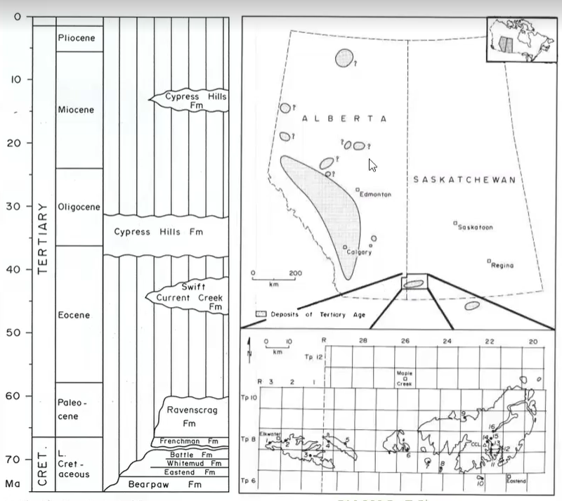
Cypress Hills Gravels and Conglomerates
Cypress Hills preserve thick conglomerates.
They’re capped by these thick conglomerates.
Contain large cobbles that seems to have covered the entire province. You need high velocity water to transport coarse rocks long distances.
Represent highly energetic depositional systems.
Evidence for High-Energy Transport
Large cobble sizes.
Deep scour surfaces.
Percussion marks on cobbles.
Cobbles collided during transport.
Must have been fast-moving, high velocity water to bang huge rock together and form large scours.
Major Geological Question
How were large cobbles transported across such large portions of Alberta?
Especially puzzling because coarse material is usually deposited near mountain sources.

Interpretation 1
Cobbles sourced from:
Sweetgrass Hills.
Bearpaw Mountains.
Transported by braided rivers that produced the conglomerates and glaciers would come and erode, hence letting a few areas of these deposits preserved (like Cyprus Hills).
Later modified by glacial erosion.
Limitation:
Difficult to explain province-wide distribution.
Sweetgrass hills and Bearpaw Mountains don’t occur everywhere in the province… which is why it falls short in terms of interpretation.

Interpretation 2
Mountains were once significantly higher.
Massive erosion removed several kilometers of rock (3km-10km according to this interpretation… but this much erosion seems unrealistic).
Uplift and heavy erosion occurred during this time and were deposited across the plains in braided rivers.
Braided rivers spread sediments across Alberta.
Later glaciation modified the landscape further.
Helps explain widespread gravel distribution.
Archaeological Significance of Gravels
Indigenous peoples utilized cobbles for:
Knives.
Spear points.
Axe heads.
Other stone tools.
Archaeological surveys around Swan Hills examine:
Resource extraction sites.
Processing areas.
Trade networks.
Tool production.
Transition to Quaternary Glaciation
Final topic of the course.
Focus shifts from Tertiary deposits to glacial processes.
Basic Glacier Structure

Accumulation Zone
High-elevation region.
Snow and ice continuously added.
Ice persists year-round.
Always stays cold enough so the glacier doesn’t disappear.
Ablation Zone
Lower-elevation region.
Ice lost through melting and sublimation.
Net decrease in glacier mass.
The area where the glacier loses ice.
There is a elevation change between the Accumulation Zone (higher up) and the Ablation Zone (lower).
Glacier Head
Thickest portion of glacier.
Located in accumulation zone.
Crevasses
Large fractures within glacier ice.
Form as flowing ice deforms and breaks.
Cracks in the ice.
Ice Channels:
Inside glaciers… has channels.
Glacier Safety
Glaciers are extremely dangerous.
Hazards include:
Deep crevasses.
Hidden meltwater channels.
Ice collapse.
Walking on glaciers without training or guides strongly discouraged.
Glacier Movement:
Along the base, there is often pressure melting → forms a liquid interface where it continuously freezes (to the sediment) and thaws.
That sediment is accumulated into the ice as it flows along.
Glacial Erosion Mechanisms
Plucking
Ice freezes onto bedrock or sediment.
Material becomes incorporated into glacier.
Material removed as glacier moves.
Abrasion
Rocks frozen into glacier scrape underlying bedrock.
Produces scratches and grooves.
Moraines
Sediment transported within ice.
Deposited when glacier melts.
Sediment that was accumulated within the ice… which melted out at the abrasion area.
Pleistocene Ice Sheets

Laurentide Ice Sheet
Covered most of Canada.
Main ice sheet affecting Alberta.
Cordilleran Ice Sheet
Mountain-based glacier system.
Associated with western mountains.
Modern Alberta Glacier Examples
Angel Glacier at Mount Edith Cavell.
Columbia Icefield.
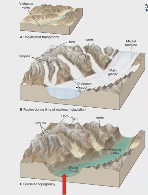
Effects of Glacial Erosion
River valleys widened and deepened.
V-shaped valleys converted into U-shaped valleys.
Mountain landscapes became more rugged.
Topography becomes more jagged.
Horn
Sharp peak formed by erosion from multiple directions.
Arête
Narrow ridge between glacial valleys.
Cirque
Bowl-shaped depression formed by glacier erosion.
Truncated Spur
Ridge cut off by a glacier.
Arete that been chopped off by the main glacier.
Hanging Valley
Tributary valley left elevated above main valley.
Tarn
Small lake occupying a former cirque basin.
Striations
Scratches carved into bedrock by glacier movement.
Record ice-flow direction.
Used to reconstruct glacial movement patterns.
Erratics
Large rocks transported by glaciers.
Deposited far from original source.
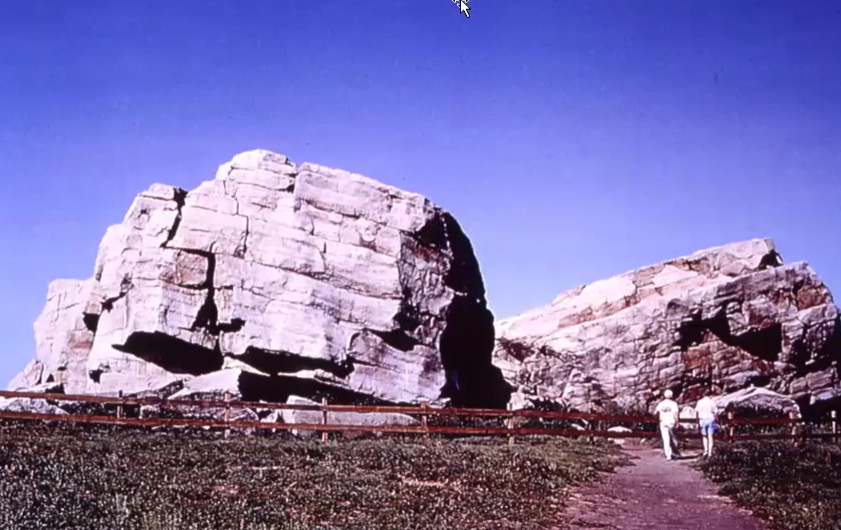
Big Rock
Famous glacial erratic in Alberta.
Composed of Gog Group quartzite.
Recognized as the world's largest erratic.
The world’s largest erratic.

Drumlins
Streamlined hills formed beneath glaciers.
Pushes the sediment, gets over the sediment, and goes.
Indicate direction of glacier movement.
Common near Calgary.
Visible from Highway 2.
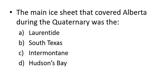
ANS: A