RM Fundamentals 2
2.1 On the Ground, In the Air, In Space
sensors have to be away from the target or surface that it’s being observed, so it is put on some stable platform
Ground-Base sensor: used for detailed information
Aircraft: also collect very detailed images
Satellites: revolve around the earth for communication, RM, and telemetry
2.2 Satellite Characteristics: Orbits and Swaths
Satellite paths are called orbits
Geostationary orbits: the orbits that satellites can have when at high altitudes and can view the same portion of the earth’s surface at all times
near-polar orbits: satellites that are designed to follow an orbit (N-S) while earth spins (E-W), covering the entire planet
sun-synchronous: cover a part of the earth with the local time of sun in the sky (ensures consistent illumination conditions over a period of time)
2.3 Spatial Resolution, Pixel Size, and Scale
the greater the distance from the target, the less detail
spatial resolution: the size of the smallest possible feature that can be detected, depends on their Instantaneous Field of View (IFOV)
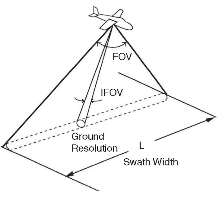
Resolution cell: aka ground resolution- determines a sensor’s max spatial resolution
2.4 Spectral Resolution:
describes the ability of a sensory to define fine wavelength intervals
2.5 Radiometric Resolution:
radiometric characteristics describe the actual information content in image- by its sensitivity to the magnitude of the EM energy
can give distinction to slight difference in energy
the finer a radiometric resolution of a sensory is, the more sensitive it is to finding small differences in energy
2bit image = 2², 8bit image = 2^8, 8bit image is clearer
2.6 Temporal Resolution:
temporal resolution for a RM system to image the exact same area at the same viewing angle a second time is equal to the period is takes to complete an orbit around the earth
2.7 Cameras and Aerial Photography
cameras are framing systems that require an immediate photo of an area
the camera systems are passive(natural) optical sensors that use a lens to form an image at the focal place, where the image is sharply defined
panchromatic film: a type of photographic film that is sensitive to UV- makes black and white images
normal color photographs: the layers are sensitive to blue, green, and red (resembles how our eyes see the environment)
false color photograph: targets are opposite colors that we see them to be
the focal length of a camera determines the angular view of view of the lens, the longer the focal length, the smaller the area covered but in greater detail
Oblique aerial photographs are taken on the side of the aircraft and show the 3D
vertical photographs: most common and used for picturing lots of land and to no depth
2.8 Multispectral Scanning
many electronic remote sensors use scanning systems- sensor w/ narrow FOV to make 2D image
across-track scanners scan the earth in lines, perpendicular to the movement of the sensor machine - also 2D
Constraints
The spectral range of photographic systems is restricted to the visible and near-infrared regions while MSS systems can extend this range into the thermal infrared
Multi-band or multispectral photographic systems use separate lens systems to acquire each spectral band
Photographic systems require a continuous supply of film and processing on the ground after the photos have been taken. The digital recording in MSS (multispectral systems) systems facilitates transmission of data to receiving stations on the ground and immediate processing of data in a computer
environment.
2.9 Thermal Imaging
thermal sensors use photo detectors that detect the contact of photons on their surface to find emitted radiation (detectors themselves need to be very cold)
thermal sensors measure surface temp and properties
there is less atmospheric scattering with thermal radiation compared the visible radiation because thermal radiation has a longer wavelength
can be used during night because thermal radiation is emitted and not reflected
2.10 Geometric Distortion in Imagery
distortions can be caused by: motion of scanning systems, platform altitude and velocity, curvature/rotation of the earth
2 types of geometric distortion:
learning away from the edges of the swath
compression of image features at points away from the nadir (caused by the rotation of scanning optics, scanning larger areas toward edge of FOV)
2.11 Weather Satellites/Sensors
GOES ((Geostationary Operational Environmental Satellite) System for weather monitoring and forecasting— atmospheric temp, winds, moisture, and cloud cover
2 GOES can be put in geostationary orbit
the newest GEO-8 has separate imagine and sounding instruments, the imager has 5 channels for sensing visible, infrared reflected, and emitted solar radiation (allows sensing day and night)
most important sensor of NOAA satellites: Advanced Very High Resolution Radiometer
(AVHRR).
The AVHRR sensor detects radiation in the visible, near and mid infrared, and
thermal infrared portions of the electromagnetic spectrum, over a swath width of 3000 km
used for weather and forecasting, monitoring land features (sea surface temps, vegetation + crop conditions)
2.12 Land Observation Satellites/Sensors
Landsat was a satellite to specifically monitor the earth’s surface collecting multispectral data with an unmanned satellite platform— was a success
Its Success:
used lots of sensors with spectral bands made for specifically Earth observation
good areal coverage (swath)
mainly on sunsynchronus orbits
SPOT (Système Pour l'Observation de la Terre)
made for earth observation data and sunsynchronus
has twin high resolution visible imaging systems (HVR)
uses off nadir viewing that allows sensors to point away from nadir and increases ability to monitor more locations and more cloud free images — used for terrain interpretation, mapping, and visual terrain simulations
very fine spatial resolution and pointable sensors, allows it to perform urban mapping efficiently
IRS (Indian Remote Sensing) Satellite Series
combination of features from Landsat, and the SPOT HRV sensor
MEIS-II (Multispectral Electro-optical Imaging Scanner)
first use of pushbroom
CASI (Compact Airborne Spectrographic Imager)
leader in airborne imaging, the first commercial imaging spectrometer.
2.13 Marine Observation Satellites/ Sensors
Coastal Zone Color Scanner (CZCS)
made to scan earth’s oceans and water bodies— color and temperature
also detect pollutants and nature of materials in water column
ran sunsynchronus and six spectral abnds (vis, near IR, thermal)
Marine Observation Satellite (MOS-1)
satellites carry three different sensors: a four-channel Multispectral Electronic Self-Scanning Radiometer (MESSR), a four-channel Visible and Thermal Infrared Radiometer (VTIR), and a two-channel Microwave Scanning Radiometer (MSR), in the microwave portion of the spectrum.
SeaWiFS (Sea-viewing Wide-Field-of View Sensor)
on SeaStar spacecraft, advanced sensor designed for ocean monitoring
8 spectral bands
2.14 Other Sensors
FLIR (Forward Looking infraRed ) systems
similar to thermal sensors but gives slanted perspective of earth’s surface instead of nadir’s direct
high spacial resolution (distinguish between 2 objects well)
Laser Fluorosensor
illuminate target with a specific wavelength of radiation and detect the multiple wavelengths of flouresced radiation
Lidar (Light Detection and Ranging)
laser light emitted from sensory and detects the energy reflected
time it takes to get the reflected energy tells the sensory its distance
Lidar used to measure heights of objects and water depth
Radar (Radio Detection and Ranging)
active sensors that make their own EM energy
emit microwave radiation, slanted perspective and looking for the surface perpendicular to the direction of motion
the reflected microwave radiation is measured and times to also determine range or distance
can produce a 2D image
2.15 Data Reception. Transmission, and Processing
3 Ways of transmitting data from aerial satellite platforms:
data is sent directly to a GRS (ground receiving station) that has to be in line with the satellite
record data on board the satellite for transmission to GRS later on
relay data to the GRS through TDRSS (Tracking and Data Relay Satellite System), series of communications satellites in geosynchronus orbit— data passed through 1 satellite to another until it reachers the GRS
the data is sent to GRS in a format of : raw and digital
raw digital format → standardized format (after correcting distortions)
data stored in CD’s, tapes, or disks and archived