Major Landforms - Geo
Major Landforms
Introduction -
Landforms - are natural features on the Earth's surface, defined by their shape and structure, and created through geological processes like erosion and tectonic activity.
Formation of landforms:
2 types of processes- Endogenous and exogenous processes.
Endogenous processes: The large scale processes that happen within the earths crust, hence resulting in the movement of convergent plates.
Formation of Mountains and Deep sea Trenches Convergent plates.
Divergent Plates - Rift valleys
Exogenous processes: These occur on the Earth's surface, such as weathering, erosion, and sedimentation, which are influenced by external forces like water, wind, and ice.
MOUNTAINS -
The elevated part of the earth’s crust, is conical in shape with steep sides the movement of the plates is very slow hence takes a long time for them to form and evolve into their present-day structures.
PEAK - highest point of the mountain
RANGES - Number of mountain peaks that are connected and form a continuous series, often spanning across vast distances and creating unique ecosystems.
MOUNTAIN SYSTEM - Several parallel or less parallel ranges are called a mountain system
Types Of Mountains -
Fold mountains -
Formed during an endogenous process, where sedimentary rocks fold upward( anticline) or downward ( Syncline) to form a series of folds. 2 types - young fold mountains = 10 to 25 million yrs
Old fold mountains = 200+ mil yrs AKA residual mountains.
Eg - Himalayas, Aravallis
Block Mountains - enormous pressure formed under the Earth’s crust that causes whole blocks of rocks to fracture (Faults). Abv or below the surrounding area. Forms in a horst and Graben.
EG - Black Forest
Volcanic Mountains -
Formed when :
magma deep within the earth erupts when it comes out its called lava. After cooling lava forms a cone of rock this process keeps repeating to lay on top of each other.
EG - Mt. Fujiyama
Importance Of Mountains:
Major sources of fresh water sources. ( Perennial River )
Cause Orographic rainfall and Act as a climatic barrier.
Hydroelectric powers are built over here because the rivers which flow here have High Velocity.
Huge reserves for minerals
Maintain Ecological Balance
PLATEAUS :
Flat Elevated land with steep slopes. Upliftment of the Earth’s Crust (Disected Plateau) / Volcanic Activities( Volcanic Plateaus)
FORMATION -
Volcanic Activity: Plateaus often form from extensive lava flows during volcanic eruptions, which solidify and create elevated flatland areas.
Tectonic Uplift: Plate tectonics can lift large sections of Earth's crust, resulting in the formation of plateaus through a process called orogeny.
Erosion: Long-term erosion of surrounding land by water and wind can leave behind resistant rock masses that become plateaus.
Sedimentary Deposition: Layers of sedimentary rocks deposited over time can build up and harden, leading to the formation of plateaus.
Types Of Plateaus - ‘
Intermontane Plateaus | Bordered By Mountains | Tibetan Plateau | 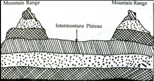 |
Piedmont Plateaus | One side Mountains other side plain or sea | Pantagonian Plateau | 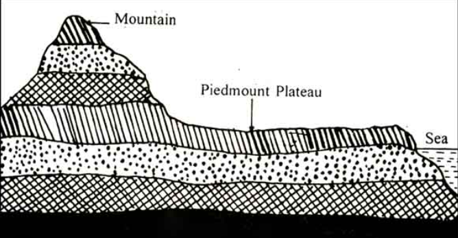 |
Continental Plateaus | Uplifted abruptly in coastal plains | Arabian Plateau | 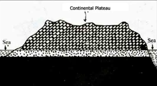 |
Plateaus - a rich source of minerals.
It is much easier to obtain minerals from plateaus than from Mountains. The Deccan Plateau and the Western Australian Plateau are a few examples. they are very good reserves for iron, manganese, Gold and Diamonds.
The Edges of Plateaus may give rise to picturesque waterfalls.
These Places are major revenue earners as the popular tourist attractions.
VALLEYS -
The low-lying areas between mountains
3 types -
Rift Valley: A linear low-lying land between mt ranges. The Rhine Rift Valley is one of the major rift valleys on Earth. Length = 350 km, width - 50 km.
In India, The River Narmada Flows Through a Rift valley Between the Vindhya Ans Satpura Ranges.
River valley -
It’s formed by flowing rivers. It has a V-shaped structure.
Glacial Valley -
It is formed by the movement of glaciers. It has a U-shaped structure.
PLAINS -
Gently sloping, almost flat land.
Types of plains -
Structural plains | Horizontal surfaces, formed due to elevation of a part of the sea floor EG - Great Plains Of The USA |
Erosional plains | continuous and long-term erosion of uplands. Where agents like glaciers erode highlands forming 2 types of plains - Peneplains, and pediplains (Sahara Desert) |
Depositional plains | Formed due to depositional activities - Alluvial plains - River deposits - Gangetic Plain Lake plains - Lake deposits - Manipur plain Drift plains - Glacier deposits - Canadian plains Loess plains - wind deposits - loess plateau |
IMPORTANCE OF PLAINS -
Suitable for agriculture
Fertile soil
Food Baskets
Easy to build roads, railway lines, etc.
Most of the population
Landforms and people -
People living in the mountains reside in wooden houses for warmth and predominantly engage in small industrial work. In contrast, the plains offer flat land ideal for agriculture, providing fertile soil, a better lifestyle, and more employment opportunities.