Rivers
The World’s Water Supply – The Hydrological Cycle
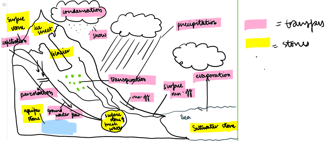
The Hydrological Cycle: Characteristics, Stores, and Transfers
The hydrological cycle is a closed system, meaning no water is lost or gained, only transferred between different stores through various processes.
Key Water Stores:
Oceans (97%) – The largest store of water, mainly saltwater, which is not directly usable for drinking or irrigation.
Glaciers & Ice Caps (2%) – Freshwater stored as ice in places like Antarctica and Greenland; a significant source of freshwater but largely inaccessible.
Groundwater (0.7%) – Water stored in permeable rocks (aquifers) beneath the Earth's surface, providing an important source for wells and boreholes.
Rivers & Lakes (0.01%) – Surface water that supports ecosystems and human activities such as drinking water supply, agriculture, and industry.
Atmosphere (0.001%) – Water vapour present in clouds, playing a key role in weather and precipitation patterns.
Biosphere (smallest store) – Water stored in living organisms, especially in plants through transpiration.
Key Transfers in the Hydrological Cycle:
Hydrosphere: All the water stored on the Earth’s surface and in the atmosphere.
Hydrological Cycle: The total process of water moving from land and ocean to the atmosphere and returning as precipitation.
Evaporation: Liquid water turns into water vapour due to heat.
Condensation: Water vapour cools and changes back into liquid water.
Precipitation: Water falls from clouds to Earth as rain, hail, or sleet.
Transpiration: Water evaporates from the leaves of plants and trees.
Surface Water: Water stored on the Earth’s surface, such as in lakes and ponds.
Surface Runoff: Water flowing across the Earth's surface, like in rivers.
Groundwater: Water stored underground, e.g., in aquifers.
Groundwater Flow: Water moving through the ground, such as in underground rivers.
Infiltration: Water soaking into the ground.
Percolation: Water moving downward through soil and rock layers.
Transfer: The movement of water from one store to another.
Store: A location where water is held or contained.
River regime:
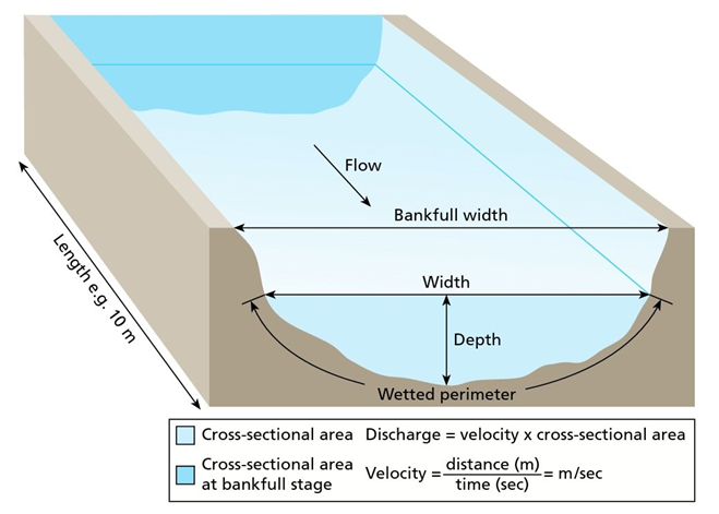
A river regime refers to the pattern of a river's flow or discharge over the course of time - the amount of water carried by a river at any one time
Discharge is measure in cumecs - cubic metres per second past particular points along the river course
Changes to the river regime refers to a change in the discharge of a river
Factors that influence river regime:
Climate: The most influential factor on river regimes.
Precipitation: Rainfall amount, intensity, and duration affect water flow; cold areas store water as snow/ice, which later melts (e.g., Ganges fed by Himalayan snowmelt).
Temperature: Warmer temperatures increase evaporation and water vapour, often resulting in more precipitation.
High Vegetation: Intercepts rainfall, slowing it down and increasing infiltration while reducing surface runoff.
Deforestation: Alters river regimes and increases seasonal variations in river discharge.
Rock Type: Porous and permeable rocks store groundwater, which feeds rivers as base flow.
Porosity: Rocks with higher porosity hold more water.
Permeability: Determines how easily water flows through rocks; connected pores are required for permeability.
Compacted Soils: Reduce infiltration and increase surface runoff.
Sandy Soils: Drain quickly and dry out easily.
Clay Soils: Drain poorly due to small particles and limited air spaces.
Human Impact: Activities like grazing compact soil and reduce infiltration.
Urban Areas: Have impermeable surfaces, leading to faster runoff and less infiltration.
Drainage Systems: Designed to remove water quickly, often directing it into rivers.
Water Abstraction: Groundwater removed for consumption and irrigation lowers water tables and alters surface flows.
Dams: Control river flow for flood prevention, irrigation, hydropower, and supply; reservoirs can lose water through evaporation.
Example: Libya's 2023 flood caused by dam failure, leading to severe flooding.
Basin Size/Shape: Small basins respond quickly to rain.
Slope Gradient: Steeper slopes cause more surface runoff.
Drainage Density: Basins with many rivers respond quickly to storms.
Storm hydrographs:
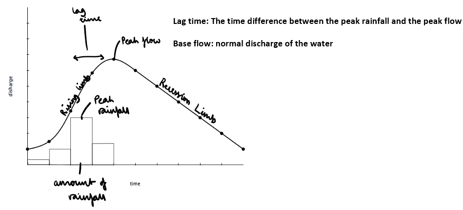
Understanding storm hydrographs:
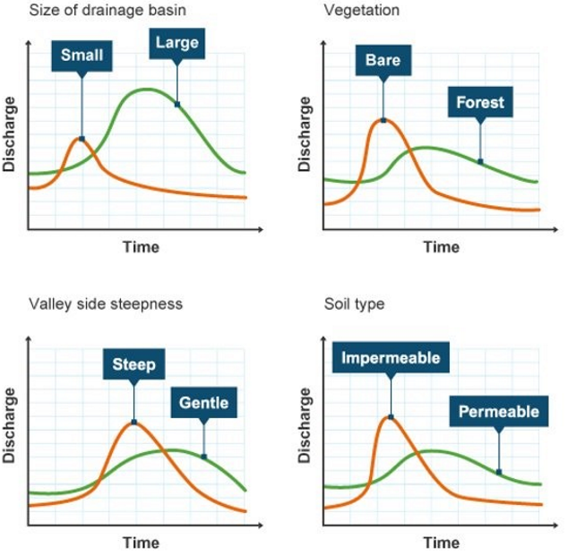
Small drainage basin: Less land for water to flow over/under. Less streams (less water).
Large drainage basin: More land (takes longer) and more water flowing
Bare: No interception, flows quickly overland. Water is not lost/stored in trees
Forest: Interception, water stored by trees. Less water flowing and it flows as groundwater flow
Steep: Faster flow. Less time to infiltrate as it is flowing as surface run0ff. Less stored as groundwater
Gentle: Slow flow of water. More time for infiltration because it is not flowing.
Impermeable-(concrete): Less infiltration so water flows quickly as overland flow.
Permeable: More infiltration and less water flowing as overland flow.
Features of a Drainage Basin
A drainage basin is an area of land where precipitation collects and drains into a common outlet, such as a river, lake, or ocean.
Key Features:
Source – The starting point of a river, often found in highland areas.
Watershed – The boundary separating one drainage basin from another, often marked by hills or mountains.
Tributary – A smaller river or stream that flows into a larger river.
Confluence – The point where two rivers meet.
Channel Network – The interconnected streams and tributaries within a drainage basin.
Mouth – The point where a river flows into a larger body of water, such as an ocean or lake.
Weathering:
Physical/ freeze thaw weathering:
Water enters the crack. Temperatures fall at night causing the water to freeze.
When water turned to ice it expands by ten percent. This puts pressure on the rock prising the crack apart.
The ice melts, water seeps deeper into the crack and freezes again.
Over a long period of time, large blocked of rock can be shattered by repeated freeze-thaw weathering.
Biological weathering:
Caused by plants, animals, fungi, and microorganisms; common in drainage basins due to root activity.
Plant Roots: Grow into rock cracks, widening and weakening them.
Animals: Trample soil or dig, disturbing vegetation and surface.
Fungi: Create tiny tunnels by penetrating minerals.
Organic Acids: Released by roots, help dissolve minerals.
Microbes: Alter chemical makeup of rocks, aiding further weathering.
Chemical weathering:
Chemical weathering refer to the weather of rocks by rainwater which is slightly acidic.
It is most effective below the surface as percolating water has gained organic acids from the soil and vegetation it has passed through.
It is most prominent with rocks like limestone and granite.
Mass movement:
Slumping – Occurs when a significant section of rock moves a short distance down a slope in a rotational movement. This often occurs when softer materials overlie more resistant impermeable materials. The softer material becomes saturated with rainwater and as a result slides downwards.
Soil creep – A slow small scale movement of individual soil particles downslope under the influence of gravity. It moves at a rate of 1-3 mm per year in tropical areas. Frequently occurs on slopes with an angle more than 5 degrees.
Physical Processes That Shape River Landforms
Fluvial Processes in River Valleys and Channels
Erosion (Wearing Away of River Banks & Bed):
Hydraulic Action – The sheer force of water hitting riverbanks compresses air into cracks, gradually weakening the rock.
Abrasion (Corrasion) – Rocks and sediment carried by the river scrape against the riverbed and banks, wearing them away.
Attrition – Rocks and pebbles collide with each other, breaking into smaller, smoother pieces over time.
Solution (Corrosion) – River water dissolves minerals from rocks, particularly in limestone areas.
Transportation (Movement of Material):
Traction – Large rocks and boulders roll along the riverbed, requiring high energy.
Saltation – Small pebbles bounce along the riverbed in a hopping motion.
Suspension – Fine particles like silt and clay are carried within the water.
Solution – Dissolved minerals travel in the water, invisible to the eye.
Deposition (Dropping of Material When Energy Decreases):
Deposition refers to when materials in a river fall out of transportation because of a lack of energy to carry out the material. This can happen when:
Gradient decreases
Discharge falls during dry periods
Current slows on the inside of a meander
River enters a lake or sea
Deposition leads to the formation of floodplains, deltas, and levees.
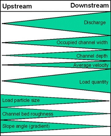
Bradshaw model:
The Bradshaw Model is a theoretical tool that shows how river characteristics change from source to mouth.
It compares features found more commonly upstream or downstream.
Key features include discharge, velocity, channel width and depth, and landscape changes.
Discharge increases downstream due to more water flow.
Channel bed is rougher upstream and smoother downstream as higher flow erodes and smooths it.
How River Landscapes Change Along Their Course
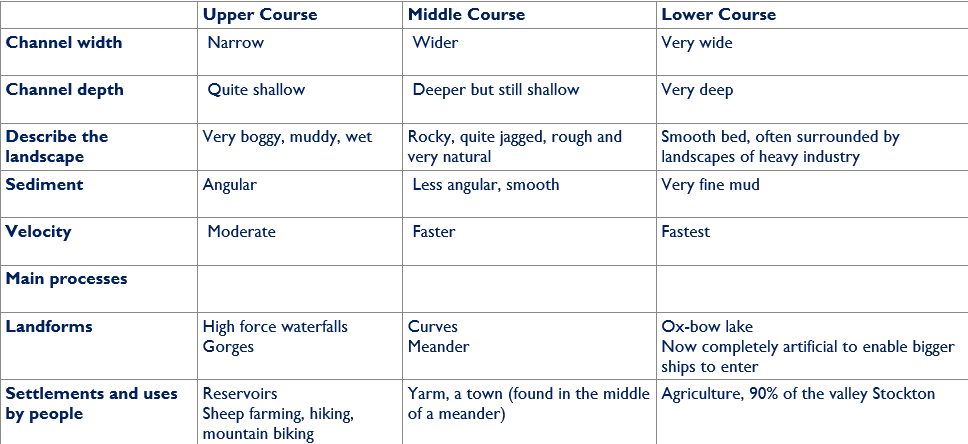
Upper Course:
Upper Course Characteristics
Channel Width: Narrow
Channel Depth: Quite shallow
Landscape: Very boggy, muddy, and wet terrain with steep gradients. The impermeable rock in the area contributes to rapid surface runoff.
Sediment: Angular and rough due to limited transport downstream.
Velocity: Moderate, though the steep gradient can lead to faster-moving water in certain sections.
Main Processes: Vertical erosion dominates, with processes such as hydraulic action and abrasion shaping the landscape.
Landforms:
High Force Waterfall: A dramatic 21-meter drop over the resistant Whin Sill rock, one of the most famous waterfalls in the UK. Below the waterfall, a gorge has formed due to the retreat of the falls over time.
Gorges: Created as the river cuts back through the resistant rock layers, leaving steep-sided valleys behind.
Settlements and Human Use:
Reservoirs: Cow Green Reservoir was built to regulate river flow and supply water to industrial areas downstream.
Farming and Tourism: The sparse population relies on sheep farming due to the rugged terrain. The area also attracts hikers and mountain bikers who explore the natural beauty of the Pennines.
Middle Course:
Channel Width: Wider
Channel Depth: Deeper, but still relatively shallow compared to the lower course.
Landscape: Rocky and jagged, with rough but increasingly smoother riverbeds. The natural landscape transitions to more fertile floodplains.
Sediment: Sediment becomes less angular and more rounded as it is transported downstream.
Velocity: Faster, as the river's gradient decreases but its discharge increases due to tributaries joining.
Main Processes: Lateral erosion becomes dominant, with transportation processes such as traction, saltation, and suspension carrying sediment downstream.
Landforms:
Meanders: Large meanders, such as those near Barnard Castle and Yarm, form as lateral erosion shapes the outer bends, and deposition occurs on the inner bends.
Floodplains: Fertile floodplains begin to form as fine sediments are deposited during flooding events.
Settlements and Human Use:
Yarm: A historic town located in the middle of a large meander.
Yarm has been prone to flooding, prompting the construction of flood defenses such as levees and walls.
The fertile floodplain soils support agriculture in the surrounding area.
Tourism: Towns like Barnard Castle attract visitors with their historic sites and picturesque scenery.
Agriculture: The floodplains are used for farming, benefiting from the rich alluvial soil deposited by the river.
Lower Course:
Lower Course Characteristics
Channel Width: Very wide
Channel Depth: Very deep, particularly near the estuary.
Landscape: Smooth riverbed with surrounding landscapes dominated by heavy industry and urban areas.
Sediment: Fine mud and silt dominate as the river slows and deposits its load near the estuary.
Velocity: Fastest, as the river is wide, deep, and flows efficiently.
Main Processes: Deposition dominates, with fine sediment settling in the slower-moving water near the estuary.
Landforms:
Floodplains and Levees: Expansive floodplains with natural levees formed by sediment deposition during floods.
Ox-Bow Lakes: Occasionally form from abandoned meanders, though rare due to modifications.
Artificial Channel: Much of the lower course has been artificially modified to allow larger ships to navigate to ports and industrial areas like Teesport.
Estuary: The river flows into the North Sea, creating a large estuary with mudflats, sandbanks, and salt marshes that support diverse ecosystems.
Settlements and Human Use:
Stockton-on-Tees: Once a major port and industrial hub, Stockton has seen significant development over centuries. The Tees Barrage, built in this area, helps control tidal flow, prevent flooding, and improve navigation for recreational and commercial purposes.
Middlesbrough: The lower course is heavily industrialized, with industries such as chemical plants, oil refineries, and steelworks located near the estuary. Channel straightening and dredging have been carried out to facilitate shipping and industrial needs.
Agriculture: The surrounding valley is used extensively for farming, with 90% of the land dedicated to agricultural activities.
Environmental Efforts: Conservation projects aim to restore habitats such as mudflats and salt marshes and improve water quality affected by industrial activity.
Upper course landforms:
V shaped valleys:
Very steep sides, Forms a V-shape, a narrow channel, very green, not a lot of vegetation, barren. Limited human use.
Vertical erosion, a lot of vertical erosion but limited lateral erosion as the river does not have enough power,
Freeze-thaw weathering as rocks are exposed(will help with the steepness of the land), the land is also quite wet and damp, streams are small as they are in their infancy.
Interlocking spurs:
In the upper course, the river does not have a huge amount of energy to erode as it does not have a high discharge and it has to transport large pieces of sediment.
When the river meets area of harder rock that are difficult to erode, it winds around them. A series of hills form on either side of the river called spurs.
As the river flows around these hills as they become interlocked.
So, a series of interlocking spurs are often found in the upper course of a river valley.
Formation of a waterfall:
Different layers of rock
Hard layer of limestone, is very hard, hard to erode
The rocks at the bottom (soft layers of sandstone) of the water is much more subjected to erosion, softer
Overtime, the erosion that causes the soft rock to slide away, a waterfall forms
It creates an overhanging, the hard rocks then becomes unstable and leads to it collapsing
This leads to the waterfall slowly retreating upstream
As the waterfall keeps retreating upstream, a gorge forms from it as it has steep sides etc
Rapids:
Definition: Fast-moving, turbulent sections of a river.
Formation Process:
Steep Gradient: Rapids occur where the riverbed has a steep slope, causing water to flow quickly and turbulently.
Uneven Riverbed: Rocks and boulders create turbulence as water flows over them, increasing speed and causing choppy currents.
Differential Erosion: Softer rock layers erode faster than harder ones, creating step-like features and increasing flow velocity.
Water Volume and Speed: Higher water volume or rainfall intensifies flow, contributing to faster-moving water and turbulence.
Sediment Interaction: Water mixed with sediment (sand, gravel) increases erosive power, further developing rapids.
Turbulent Flow: Water moves irregularly with swirling eddies, forming foam and white-water.
Visuals – Before and After Rapids Formation:
Before: Calm river with a relatively flat bed and slow-moving water.
After: Fast-moving water with visible turbulence, foam, and water drops over rocks and boulders.
Potholes
Definition: Cylindrical or conical depressions in the riverbed caused by water and sediment abrasion.
Formation Process:
Hydraulic Action and Abrasion: Water and sediment swirl in one spot, eroding the bedrock and creating depressions.
Vortex Action: Swirling water (vortices) concentrates energy on specific areas, deepening the depression.
Sediment Grinding: Sediment particles grind against the riverbed, widening and deepening potholes over time.
Cumulative Erosion: Continuous water flow and sediment abrasion deepen and expand thepotholes.
Size and Depth: Varies based on water speed, sediment load, and erosion duration.
Visuals – Before and After Pothole Formation:
Before: A smooth riverbed with minimal depressions.
After: Deep, circular depressions, often smooth and polished at the bottom.
Key Differences Between Rapids and Potholes:
Rapids form from steep gradients and uneven riverbeds causing fast, turbulent water.
Potholes form from swirling water and sediment abrasion, creating depressions in the riverbed.
Middle course landforms:
The gradient here is gentle + lateral erosion has widened the river channel
River channel has deepened
Bed load-smaller
Larger river channel = LESS FRICTION which means water flows faster
Meanders:
As the river erodes laterally, it forms LARGE BENDS and then horse-shoe like loops called MEANDERS
Formation of meanders is due to both DEPOSITION + EROSION and meanders gradually migrate downstream
Force of river ERODES + UNDERCUTS riverbank on outside of the bend where water flow has the most energy due to decreased friction, this forms a river cliff
On the inside of the bend, where the river flow is slower, material is deposited, due to increased friction, leading to slip-off slopes
Ox bow lake
Meander Formation: A river develops large bends (meanders) in its middle or lower course due to lateral erosion and deposition.
Erosion on Outer Banks: Erosion (mainly hydraulic action and abrasion) wears away the outer bend where water flows faster.
Deposition on Inner Banks: Slower flow on the inner bend causes deposition, narrowing the neck of the meander.
Neck Cut-Off: During high flow or flooding, the river cuts through the narrow neck, creating a new, straighter channel.
Ox-Bow Lake Formation: The old meander loop is left behind and cut off from the main flow, forming an ox-bow lake.
Lower course landforms:
Floodplain:
A flood plain is a wide area of flat land on both sides of a river
A flood plain is a deposit oval feature
They from due to both erosion and deposition. Lateral erosion widens the valley and removes any interlocking spurs, creating a wide flat area on either side of the river. The floodplain is often caused by meanders shifting along the valley.
At times of exceptionally high discharge, a river may burst its banks. Due to increased friction, material normally carried in suspension is deposited as alluvium (deposits of clay silt and sand from a river flood)
Levees:
A levee is an embankment (can be natural or man made) made up by deposited material during a river flood.
Levees occur in the lower course of a river wen there is an increase in the volume of water flowing downstream and flooding occurs
When the river floods, the sediment spreads out across the floodplain
When a flood occurs, the river loses energy. The largest material s deposited first on the sides of the river banks an smaller material further away.
After many floods, the sediment builds up to increase the height of the riverbanks, meaning that the channel can carry more water (a greater discharge) and flooding is less likely to occur in the future.
River mouth and estuaries:
A river mouth is where a river lows into a larger body of water such as another river a lake/reservoir, a bay, a sea or an ocean.
At the river mouth, sediments are often deposited due to the slowing of the current reducing the carrying capacity of the water.
An estuary is where the river meets the sea. The river here is tidal and when the sea retreats the volume of the water in the estuary is reduced.
When there is less water, the river deposits silt to form mudflats which are an important habitat for wildlife.
Deltas:
Delta’s are landforms formed at the mouth of a river, where the river meets a body of water with a lower velocity than the river e.g. a lake or a sea.
This results in the reduction in the rivers capacity to transport sediment.
Deltas are found at the mouth of large rivers, for example, the Mississippi. A delta is forms when the river deposits it material faster than the sea can remove it.
When a river meets the sea in a sheltered and shallow area, the material it carries is deposited rather than carried away out to sea.
There are 3 main types of deltas, named after the shape they create.
Arcuate or fan shaped, the land around the river mouth arches out into the sea and the river splits many times on the way to the sea, creating a fan effect.
Cuspate, the land around the mouth of the river juts out arrow-like into the sea
Bird’s foot, the river splits on the way to the sea, each part of the river juts out into the sea, rather like a birds foot.
Colorado River, USA (Developed Country)
Why the River is Being Managed
The Colorado River is essential for supplying water to over 40 million people across seven U.S. states and Mexico. It supports urban centers like Las Vegas and Los Angeles, irrigates agricultural land, and provides hydroelectric power. However, over-extraction, long-term droughts, disputes between states, and cross-border water agreements make its management crucial to ensure water availability, prevent conflicts, and preserve ecosystems.
How the River is Being Managed
Dams & Reservoirs (e.g., Hoover Dam): These structures store water for future use, control river flow, and provide hydroelectric power.
Water Conservation Measures: Policies encourage reducing water usage through efficient irrigation systems, water-saving technologies, and public education programs.
Legal Agreements (e.g., Colorado River Compact): Water-sharing agreements regulate the distribution of water between U.S. states and Mexico, ensuring equitable access to the river's resources.
Benefits of Management
Dams & Reservoirs: Provide a consistent water supply, hydropower, and flood control. Water can be stored during periods of surplus and released during dry seasons.
Water Conservation: Reduces water waste, improving efficiency and ensuring sustainable usage for agriculture, households, and industries.
Legal Agreements: Help resolve conflicts and maintain diplomatic relations between the U.S. and Mexico, ensuring a fair distribution of water resources.
Negative Impacts of Management
Dams & Reservoirs: Disrupt natural river ecosystems, affecting fish migration and causing habitat loss. Evaporation from reservoirs, especially in hot regions, reduces water availability.
Water Conservation: While it saves water, it can impact agricultural productivity, which is a significant economic sector in the region.
Legal Agreements: Tensions over water rights continue, especially during droughts, when the reduced flow of the river makes it harder to meet the demands of all stakeholders.
Yangtze River, China (Developing Country)
Why the River is Being Managed
The Yangtze River is crucial for providing water to over 400 million people, supporting agriculture, industry, and transportation. However, the river faces severe flooding, pollution, and overuse for agricultural and industrial purposes. Effective management is necessary to protect communities from flooding, ensure reliable water supply, and mitigate environmental degradation.
How the River is Being Managed
Three Gorges Dam: The dam controls floods, generates hydroelectric power, and stores water for irrigation and industrial use.
Pollution Control Laws: Stricter environmental regulations are imposed on industries to reduce pollution in the river, improving water quality.
Afforestation: Large-scale tree planting projects aim to reduce soil erosion, improve water retention, and decrease runoff into the river.
Benefits of Management
Three Gorges Dam: Provides flood control, generates significant hydroelectric power, and improves water storage for irrigation and industry.
Pollution Control Laws: Help reduce water pollution, improving the river's overall health and water quality, benefiting both humans and aquatic life.
Afforestation: Helps stabilize soil, reduce erosion, and mitigate flooding by slowing runoff and improving water infiltration.
Negative Impacts of Management
Three Gorges Dam: The dam caused the displacement of over 1.4 million people, and its construction altered the river's natural flow, harming ecosystems and aquatic species. The accumulation of sediment behind the dam also reduces its effectiveness over time.
Pollution Control Laws: Enforcement of pollution laws can be inconsistent, and industrial growth sometimes exceeds the capacity of environmental regulations to keep up, leading to ongoing pollution problems.
Afforestation: Large-scale tree planting can compete for land used for agriculture and disrupt local farming communities. It may also create monocultures, reducing biodiversity.
Uses of water:
Demand and supply:
All forms of water use revolve around 2 key elements
Demand: this is the need for water for a range of uses; it is also often referred to as consumption and the amount of water consumed reflects the level of demand
Supply: ,eating demand for water by tapping various sources, such as groundwater, lakes and rivers
For any country or area within it, we can compare water demand and water supply. This comparison is know as water balance.
Increase in demand and consumption:
Population Growth: Global population grew from 2.5 billion in 1950 to over 8 billion in 2023.
Urbanization: Urban population rose from 30% in 1950 to around 58% today, increasing household and industrial water use.
Higher Living Standards: More water-intensive appliances (e.g. washing machines, dishwashers) used in daily life.
Improved Hygiene Awareness: Increased water use for sanitation and cleanliness.
Dietary Changes: Shift from grain-based diets to protein-heavy ones (especially meat), which require more water to produce.
Climate Change: Hotter conditions increase evaporation, irrigation needs, and stress on water supplies.
Agricultural Demand: More crops grown, often inefficiently, with more water waste.
Industrial and Recreational Use: Water demand in manufacturing alone is expected to rise by 400% from 2000 to 2050.
Main sources of water:
Rivers and lakes
Reservoirs-artificial lakes created by building a dam across a valley and allowing it to flood
Aquifers and wells-much of the world’s fresh water supply lies underground. It is stored in porous rocks known as aquifers. This ground water can be extracted by drilling wells or boreholes down to the aquifer.
Factors affecting water availability:
Increasing:
Climate & Rainfall: High annual rainfall boosts water availability (e.g. tropical regions).
Glaciers & Snowmelt: Seasonal meltwater from glaciers and snow-capped mountains adds to supply.
Rivers & Lakes: Large freshwater sources (e.g. Amazon, Great Lakes) ensure consistent water.
Aquifers: Underground reserves provide water in dry areas if properly managed.
Infrastructure & Technology: Desalination, recycling, and efficient systems improve access.
Wealth: Richer nations can invest in solutions to access and purify water.
Decreasing:
Dry Climates: Desert areas receive little rain, causing chronic shortages.
Overpopulation: High demand strains limited water sources in dense regions.
Pollution: Waste and chemicals contaminate water, making it unusable.
Deforestation: Reduces groundwater recharge and disrupts rainfall patterns.
Climate Change: Increases droughts, evaporation, and unpredictable rainfall.
Poor Infrastructure: Leaks, bad irrigation, and limited storage waste water.
Political Tensions: Shared rivers (e.g. the Nile) can create unequal access and conflict.
Definitions:
Water deficit – areas where the water balance is negative-where water demand exceeds supply
Water surplus – Areas where the after balance is positive, where the supply or availability of water exceeds demand
Water neutral – areas where water demand and supply are roughly the same, where the water balance is equal
Things that influence water quality:
The composition of surface and groundwater has an impact on water quality and depends on 2 factors:
Natural conditions in the drainage basin
Human intervention:
Industry(fast fashion; the release of dangerous chemicals, sweatshops)
Dams built in rivers
Construction e.g. Bridges where the river bed is covered in concrete
Oil spills
Pesticides and fertilisers
Urban runoff pollution from cars factories and other sources
Factors impacting water quality:
Agricultural Runoff: Fertilizers, pesticides, and manure pollute rivers; livestock adds faecal waste. Agriculture pollutes 40% of UK water bodies.
Sewage Discharges: Overflow systems release untreated sewage during rain; over 600,000 spills in 2023 added pathogens, microplastics, and chemicals.
Urban Runoff: Roads and cities add oil, litter, and microplastics to rivers—especially during heavy rain.
Industrial Waste: Factories release harmful chemicals and metals, damaging aquatic life and entering the food chain.
Abandoned Mines: Old mines release toxic metals (e.g., lead, arsenic) into rivers, polluting 3% of UK water bodies.
Plastic Pollution: Plastics and microplastics enter water, harming wildlife and entering the food chain.
Climate Change: Hotter weather boosts algal blooms; heavier rain causes more polluted runoff and flooding.
Deforestation: Increases erosion and sediment in rivers; less vegetation means fewer natural filters.
Coastal & Marine Activity: Oil spills, boats, and tourism contribute to marine water pollution.
Household Waste: Poor disposal of chemicals and mismanaged septic tanks pollute local water sources.
Impacts of poor water quality:
Biodiversity Loss: Polluted rivers reduce aquatic species like mussels, fish, and insects.
Health Risks: Water users may get infections or illness; toxic algae can be dangerous.
Drinking Water Contamination: More treatment is needed; nitrate levels from farming are a public health concern.
Flooding & Sediment Buildup: Pollution clogs waterways, raising flood risk and harming fish habitats.
Fisheries Decline: Pollution reduces fish and shellfish stocks, hurting local livelihoods.
Tourism Losses: Polluted beaches and rivers deter visitors—e.g., 2023 beach closures hurt local economies.
Agriculture Challenges: Contaminated water reduces crop yields and soil quality.
Climate Feedback Loop: Polluted waters release greenhouse gases like methane, worsening climate change.
Storage of clean water:
Dams and Reservoirs
Benefits:
Store water during high flow for year-round supply.
Regulate flow for drinking, farming, and industry.
Treated water is distributed to nearby areas.
Limitations:
Harm ecosystems, displace people.
Expensive to build and maintain.
Silt can reduce storage over time.
Wells and Boreholes
Benefits:
Tap into clean underground water.
Useful in dry, rural areas.
Can deliver water directly to communities.
Limitations:
Overuse depletes aquifers.
Risk of contamination from nearby land use.
Some groundwater may need treatment.
Pipelines
Benefits:
Move clean water directly to users.
Reliable for homes, farms, and cities.
Helpful in dry or remote regions.
Limitations:
Costly to build and maintain.
Leak risk and possible contamination.
Not always viable for rural areas.
Desalination
Benefits:
Turns seawater into drinking water.
Reliable for coastal and dry regions.
Useful during droughts.
Limitations:
Energy intensive and expensive.
Brine waste can harm oceans.
Hard to scale for big populations.
Cloud Seeding
Benefits:
Triggers rainfall in dry areas.
Helps fill reservoirs and support farming.
Limitations:
Unpredictable success.
Health and environmental risks.
Costly and region-dependent.
Other Management Methods
Benefits:
Rainwater harvesting and recycling cut water use.
Sustainable farming protects water quality.
Limitations:
Rain is unreliable in dry areas.
High setup costs.
Public may resist recycled water use.
Flood Management:
Causes of River Flooding
Heavy Rainfall: When intense rainfall occurs, the river's capacity to absorb and channel the water is overwhelmed, causing the river to overflow.
Snowmelt: Sudden temperature changes can cause rapid snowmelt, which increases river discharge, leading to floods downstream.
Urbanization: The construction of impervious surfaces (e.g., concrete) reduces water infiltration into the ground, increasing the volume of surface runoff into rivers.
Deforestation: The removal of trees reduces water interception and increases runoff, which can lead to higher river levels and flooding.
Flooding case study:
Pakistan 2022 Floods
Causes:
Indus River prone to flooding; monsoon started early and intensified.
Rising temperatures melting 7000+ glaciers; 3000 glacial lakes formed, 33 close to bursting.
Some provinces got 5–8× normal rainfall; temps hit 50°C.
Pakistan contributes <1% to global emissions but is 8th most vulnerable.
Lack of flood defences; glacier lakes became tourist sites.
Impacts:
1/3 of the country underwater; 33 million affected, 1500+ dead.
Worst-hit: Baluchistan and Sindh; towns submerged, infrastructure destroyed.
Communities cut off from food and clean water.
45% of cotton crops lost; $10 billion in damages.
Rise in waterborne diseases; fears of future glacier melting with temp rise.
Spain 2024 Floods
Causes:
Record-breaking storm brought 2 years' worth of rain in hours.
Climate change warmed air and sea, increasing rainfall intensity.
Emergency alerts were delayed; many were caught in low areas.
Extreme weather worsened by previous droughts; now facing severe floods.
Impacts:
Flash floods hit Valencia, especially near Magro and Turia rivers.
217+ deaths; people, cars, and homes swept away.
Entire neighbourhoods buried under mud; 5000 soldiers deployed for rescue.
Volunteers assisting with cleanup and water shortages.
Disaster zone declared to fast-track aid and rebuilding.
Public anger over late warnings; urgent need for climate resilience.
Flood Prevention Methods
Hard Engineering: Levees & Embankments
Explanation: Raised banks along rivers help contain floodwaters and prevent them from spilling into surrounding areas.
Benefits: Protects infrastructure, agricultural land, and human settlements from flooding.
Negative Impacts: Levees and embankments can disrupt natural floodplains, reduce river biodiversity, and push floodwaters downstream, exacerbating flooding in other areas.
Hard Engineering: Dams & Reservoirs
Explanation: Dams store excess water during high rainfall periods and release it gradually to reduce downstream flooding.
Benefits: Prevents sudden flood surges, provides water storage, and generates hydropower.
Negative Impacts: Dams can cause habitat destruction, disrupt aquatic life, and displace local communities, as seen with the Three Gorges Dam.
Soft Engineering: Afforestation
Explanation: Planting trees and vegetation on riverbanks or in catchment areas increases water absorption and reduces surface runoff.
Benefits: Helps stabilize soil, reduces soil erosion, and decreases the risk of floods.
Negative Impacts: Large-scale tree planting can compete for land with agriculture and may not always be effective in reducing flood risks in heavily urbanized areas.
Soft Engineering: Floodplain Zoning
Explanation: Restricting development in flood-prone areas reduces the number of properties at risk and limits the damage caused by floods.
Benefits: Reduces the economic costs of flood damage, preserves natural floodplains, and protects ecosystems.
Negative Impacts: Zoning restrictions can conflict with urban expansion and economic development, particularly in rapidly growing cities.