Geography EOY🌍
Development🌵
Development and it’s indicators
Development is the measure of economic, environmental and social progress. Key indicators include the Human Development Index (HDI), Gross National Income (GNI) per capita, life expectancy, education levels, and indicators of gender inequality and political freedom.
Measuring Development:
Economic Indicators:
Gross National Income (GNI) per capita: This measures the average income of individuals in a country, reflecting the economic output and living standards.
GDP (Gross Domestic Product): This represents the total value of goods and services produced within a country, indicating economic activity.
Income inequality: Measures how evenly wealth and income are distributed across the population.
Social Indicators:
Human Development Index (HDI): A composite measure that combines life expectancy, education (mean and expected years of schooling), and GNI per capita to assess a country's overall development.
Literacy rate: The percentage of the population that can read and write, reflecting educational attainment.
Life expectancy: The average number of years a person is expected to live, indicating health and healthcare access.
Gender Inequality Index (GII): Measures disparities between men and women in areas like reproductive health, education, and political participation
The sahel region
Africa and the Sahel region exhibit a wide range of climates and biomes, spanning from hot deserts to tropical forests and grasslands. The Sahel, a semi-arid transition zone between the Sahara Desert and the more humid savannas, is characterized by hot temperatures and seasonal rainfall.
Desertification
The spread of desert-like conditions in arid and semi arid environments. It is caused by human and physical processes. Human
processes include removal of vegetation for farming/fuel and overgrazing of livestock. This leaves soil exposed to erosion by wind and rain. Physical processes include low, unreliable, seasonal rainfall, which when it does fall is often heavy and causes soil to be eroded.
Aid
Aid, particularly international aid, is often categorized by who provides it and what its purpose is. Bilateral aid is given directly from one government to another, while multilateral aid is channeled through international organizations like the World Bank. Voluntary aid, also known as charitable aid, is provided by non-governmental organizations (NGOs) like Oxfam and UNICEF. Aid can be short-term, like emergency relief after a disaster, or long-term, focused on development projects.
Types of Aid:
Bilateral Aid: Assistance provided directly from one government to another.
Multilateral Aid: Aid channeled through international organizations, pooling resources from multiple governments.
Voluntary Aid: Assistance from NGOs and charities, often funded by donations.
Short-Term Aid: Relief and assistance provided in emergencies like natural disasters or conflicts.
Long-Term Aid: Development aid focused on sustainable improvements in areas like education, healthcare, and infrastructure.
Problems with Aid:
Corruption:
Aid money can be misused or stolen by corrupt officials, leading to waste.
Dependency:
Aid can create dependency on the donor country, hindering self-sufficiency in the recipient country.
Lack of Sustainability:
Aid projects may not be sustainable in the long run, failing to address the root causes of poverty and development issues.
Tied Aid:
Donor countries sometimes attach conditions to aid, like requiring recipients to purchase goods or services from them, which can be detrimental to the recipient's economy.
Focus on Politics:
Aid can be used for political purposes, potentially hindering long-term development goals.
Characteristics of Successful Aid:
Transparency and Accountability:
Open and transparent processes for allocating and managing aid resources.
Focus on Local Needs and Ownership:
Ensuring that aid projects align with local needs and are led by local communities.
Long-Term Commitment:
Commitment to sustainable development, rather than quick fixes or short-term interventions.
Collaboration and Partnerships:
Working collaboratively with local organizations, governments, and international partners.
Impact and Evaluation:
Regularly monitoring and evaluating the impact of aid projects to ensure they are effective and achieve their goals.
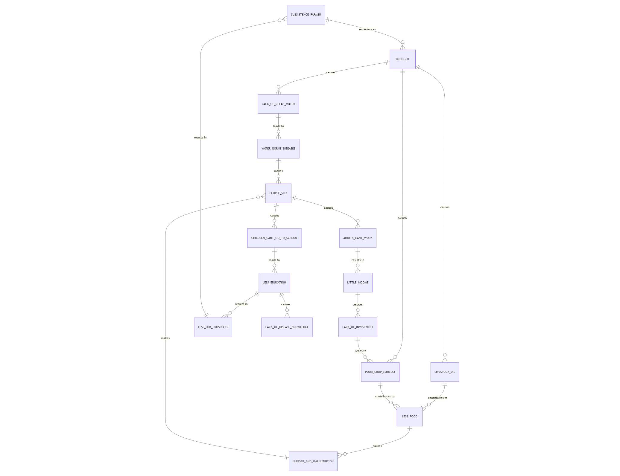
The poverty cycle
Glaciation❄
How can we explain the location of cold environments? Latitude and altitude.
Latitude and altitude significantly influence the location and characteristics of cold environments. Higher latitudes experience colder temperatures due to the Earth's curvature, which causes sunlight to reach these areas at a more oblique angle, spreading solar energy over a larger surface area. Altitude also plays a role; higher elevations generally experience colder temperatures because the atmosphere thins, reducing heat retention.
Here's a more detailed explanation:
Latitude:
Curvature of the Earth:
The Earth is round, not flat. This means that as you move away from the equator towards the poles, the sun's rays strike the surface at a more oblique angle.
Solar Energy Distribution:
Oblique angles spread the sun's energy over a larger surface area, meaning less energy is concentrated at each point.
Atmospheric Path:
The sun's rays have to travel through more of the Earth's atmosphere to reach locations of higher latitudes, leading to more scattering and absorption of solar energy.
Consequence:
This results in lower overall temperatures and more intense cold environments at higher latitudes, like polar regions and tundra areas.
Altitude:
Atmospheric Thinning:
As altitude increases, the atmosphere becomes thinner.
Reduced Heat Retention:
With less atmosphere, the Earth's surface loses heat more quickly, leading to colder temperatures.
Air Density and Pressure:
Higher altitudes have lower air pressure and density, affecting how effectively the atmosphere traps heat.
Consequence:
Higher altitude locations, regardless of latitude, are generally colder due to these atmospheric conditions.
Describing the glacier as a system (inputs, outputs, stores, accumulation and ablation)
A glacier functions as a system with inputs (accumulation), outputs (ablation), and stores of ice and material. Accumulation refers to the addition of snow and ice to the glacier, while ablation involves the loss of mass through melting, evaporation, and calving. The balance between accumulation and ablation determines whether a glacier grows, shrinks, or remains in equilibrium.
Key Components of a Glacier System:
Inputs (Accumulation):
Precipitation: Snow and hail are primary inputs, according to the National Snow and Ice Data Center.
Avalanches: Snow and ice can also enter the system through avalanches.
Eroded Debris: Material eroded by glacial processes can be transported and deposited within the glacier.
Outputs (Ablation):
Meltwater: Melting of snow and ice is a major output.
Evaporation: Direct conversion of snow and ice to water vapor (sublimation) can occur.
Calving: Large ice blocks breaking off at the glacier's snout and entering the ocean or lake.
Stores:
Ice: The primary store of a glacier, comprising the bulk of its mass.
Material: Sediment, rock, and other materials carried by the glacier are also stored.
Transfers:
Glacial Flow: The glacier moves downslope due to gravity, transferring ice and material.
Erosion and Deposition: Glacial processes erode and deposit material, influencing the landscape.
Mass Balance:
The relationship between accumulation and ablation is known as the mass balance.
A positive mass balance (more accumulation than ablation) leads to glacier growth and advance.
A negative mass balance (more ablation than accumulation) results in glacier retreat and thinning.
A neutral mass balance indicates equilibrium, where accumulation and ablation are equal.
Weathering
Weathering is the breakdown of rock in situ by chemical and and physical processes.
Freeze thaw weathering:
Initial stage - water seeps into the cracks in the rock
Freezing stage - water freezes, causing it to expand and pushes the rock apart
Shattering stage - Repeated freezing and thawing causes the rock to break apar
Freeze thaw weathering takes places in cold temperature around the freezing point to allow the water to transition to ice. In order for the water to be able to melt and freeze, the temperatures need to fluctuate between above and below 0 degrees.
Processes of erosion
Glaciers erode land through two primary processes: abrasion and plucking.
Abrasion
Mechanism:
Rocks and sediments, frozen into the base of a glacier, act like sandpaper, grinding and scraping against the bedrock beneath.
Effect:
This grinding action wears away the bedrock, leaving behind scratches called striations and creating features like rock flour (fine, silt-sized particles).
Importance:
Abrasion is crucial for deepening and shaping U-shaped valleys and contributing to the overall erosion of glacial landscapes.
Plucking
Mechanism:
Meltwater from the glacier seeps into cracks in the bedrock, freezes, and expands, further widening the cracks. As the glacier moves forward, it pulls away large pieces of rock, effectively "plucking" them from the bedrock.
Effect:
Plucking can remove entire boulders or large sections of bedrock, contributing to the creation of features like cirques, U-shaped valleys, and jagged peaks.
Importance:
Plucking is particularly effective in areas with high levels of meltwater and undulating bedrock, allowing for the formation of cavities and the efficient removal of rock fragments.
In essence:
Abrasion wears down the bedrock surface like sandpaper, creating fine particles and striations.
Plucking removes large rock fragments, effectively quarrying the bedrock and contributing to the formation of various glacial features
Landforms of erosion
U-shaped valleys, hanging valleys, misfit streams, and ribbon lakes are all landforms shaped by glacial erosion, particularly in areas with a history of glaciation. U-shaped valleys are wide, flat-floored valleys with steep sides formed by glaciers eroding V-shaped river valleys. Hanging valleys are tributary valleys that are left suspended high above the main U-shaped valley, formed when smaller glaciers didn't erode as deeply as the larger one. Misfit streams are rivers that seem too small for the wide U-shaped valley they flow through, often re-occupying pre-existing channels. Ribbon lakes are long, narrow lakes found in U-shaped valleys, often forming in areas where the glacier eroded more deeply.
U-shaped valleys:
Formation: Glaciers erode V-shaped river valleys, widening the valley floor and steepening the sides, creating a U shape.
Characteristics: Wide, flat floor, steep sides, often straight and deep.
Hanging valleys:
Formation: Smaller tributary glaciers don't erode their valleys as deeply as the main glacier, leaving them "hanging" high above the main valley.
Characteristics: A smaller valley suspended above the main valley.
Misfit streams:
Formation: Rivers flow through U-shaped valleys that they didn't carve, often re-occupying pre-existing channels.
Characteristics: Rivers that seem too small for the large U-shaped valley.
Ribbon lakes:
Formation: Form in hollows where a glacier has eroded more deeply, often in U-shaped valleys.
Characteristics: Long, narrow lakes.
Landforms of deposition
Moraines and erratics are key landforms of deposition formed by glaciers, and they include the formation of lateral, medial, and terminal moraines. Moraines are piles of debris deposited by glaciers, and these can be categorized into lateral, medial, and terminal types.
Elaboration:
Lateral Moraines:
These are ridges of debris that form along the sides of a glacier as it moves down a valley. They are composed of material that has fallen from the valley walls or been transported by the glacier.
Medial Moraines:
When two glaciers merge, their lateral moraines merge to form a medial moraine in the middle of the larger glacier.
Terminal Moraines:
These are deposits formed at the snout or furthest extent of a glacier, marking its maximum advance.
Erratics:
These are large rocks or boulders that have been transported by glaciers and deposited in areas where the rock type is different. They provide evidence of past glacial movement and can be carried long distances.
Tourism in Chamonix
Tourism in the cold environment of Chamonix offers numerous benefits, including economic impact and diverse recreational opportunities, but also presents challenges such as environmental degradation and seasonal fluctuations. The resort is a significant contributor to the local economy, attracting a large number of visitors throughout the year and providing employment. However, the increasing impact of climate change on snow cover and glacier retreat is a major concern, potentially impacting the ski industry and the region's overall appeal.
Benefits of Tourism:
Economic Impact:
Chamonix's tourist industry is a major economic driver, generating revenue for businesses, hotels, restaurants, and local communities.
Recreational Opportunities:
The resort provides a range of winter and summer activities, including skiing, snowboarding, hiking, mountaineering, and paragliding, attracting a diverse clientele.
Cultural Significance:
Chamonix is known for its history as a mountain resort, its vibrant culture, and its connection to the famous Mont Blanc massif.
Problems of Tourism:
Environmental Degradation:
Increased traffic, construction, and waste generation can lead to air pollution, noise pollution, and habitat disruption.
Climate Change Impacts:
Rising temperatures and decreased snowfall are affecting snow conditions, shortening the ski season, and threatening the region's glaciers.
Seasonal Fluctuations:
The tourist industry in Chamonix experiences significant fluctuations in visitor numbers throughout the year, leading to challenges in managing resources and staffing.
Conflicts with Local Residents:
Increased tourism can strain local resources, lead to increased traffic, and potentially disrupt the daily lives of residents.
Sustainable Solutions:
Promoting Sustainable Tourism Practices:
Encouraging eco-friendly activities, reducing carbon emissions, and promoting responsible waste management can help mitigate environmental impacts.
Diversifying Tourist Offerings:
Expanding summer tourism activities, such as hiking, cycling, and mountaineering, can help reduce the reliance on winter sports and stabilize the tourist industry throughout the year.
Supporting Local Communities:
Investing in local infrastructure, promoting local products, and providing fair wages for tourism workers can help ensure that the benefits of tourism are shared by all stakeholders.
Geographical skills🧭
Types of data
Primary data is collected first - hand by the researcher for the purpose of answering the question.
Advantages:
It’s not biased
Know how/when/well it was collected
Focus on actual question - relevant
Disadvantages:
Takes time
Costly - buying equipment
Can’t collect on large scale
Resources + access
Secondary data is collected by someone other than the researcher, for another purpose and published for others to use.
Advantages:
Takes less time
Collect a broader range of research
Disadvantages
Reliability
Some data may not be relevant
Quantitative data is collected by measuring and involves numbers e.g. collecting mm of rainfall, measuring income in £, counting frequency of cars per minute.
Qualitative data is not numerical, it involves words, photographs and drawings e.g. interviewing people to find out their opinion on a new shopping centre, taking photographs to record the quality of the environment in a town centre, drawing the types of vegetation in a hedgero
w.
Sampling techniques
Systematic data is collected at a regular set interval, such as every fifth house or every 5 metres.
Random data is when each member of the total population has an equal chance of being selected, such as when names are pulled out of a hat.
Pragmatic data is collected based on practical reasons, for example you cannot trespass on property and would not sample sediment in a deep fast flowing river.
Stratified data is used where there are groups within a population which are clearly different e.g. an area with many elderly and very young people. You would make sure your sample included a representative sample for both