ESCI weel 3-4
Lecture 7
Evolution and deep connections
A single most important idea in science
The fact of evolution makes it clear that life on earth is deeply interconnected - and we all probably share a single ancestor
Nothing in modern biology makes sense except in the light of evolution
Evolution is change
- Changes in morphology or behavior between generations
- It is not the changes that occur within a generation, that is development
What does our understanding of evolution resolve?
- Origin of complexity
- Appearance of being designed
- Adaption
- Pattern of descent
Charles Darwin (1809 - 1882)
Complexity does not arise by chance
- Natural selection
- No aim, no real direction
For natural selection to work it needs:
- The constant struggle for survival
- Variable population - mutations
- Some mechanism for passing on beneficial changes to the next generation - genes
Natural selection does not rely on chance
New species are not produced by chance rearrangement of genes in a single generation - chance is only when its for a source of variation
Change happens is tiny tiny steps - deep time
The eye
The eye has evolved in the animal kingdom at least 40 times completely independently
Even if eyes look similar they are extremely different
Homologies - deep connections between animals/plants
Body parts which occupy a similar position and/or structure (not necessarily a function) reflecting a common evolutionary ancestor
Same imdb that's been adapted differently ande for different functions
Bodies as history books
All organisms carry with them their evolutionary history. Natural selection tinkers and modifies jerry-building body parts in response to evolutionary pressure - creating a history within all of us. An illusion of design - often bad design.
Another example of bad design - larance nerve
Early on during evolution that nerve got allocated to control the larance and has just never been re-evolved
Fossils have been found through all evolutions of whales
Tiktaalik roseae
Classic intermediate step
Has some features of fish
Features of tetrapods
Halfway between a fish and an amphibian
What was happening at about the cambrian/proterozoic boundary that allows the earth system to really start to stabilise the planet
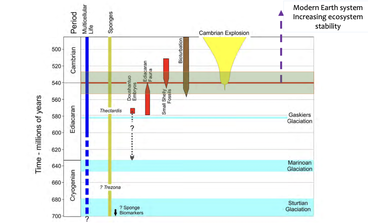
540 million years ago is when the earth system really started to start
First multicellular life 600 million years ago
Chemical evidence shows sponges have been around for a long time - 700
Cambrian explosion - explosion of more complex life with shells and complex body/mouth parts
Most of the life today is single celled life
Originally oxygen was a toxic byproduct of photosynthesis
Life in the margin of error
To a first approximation, all life on earth is extinct
Lecture 8
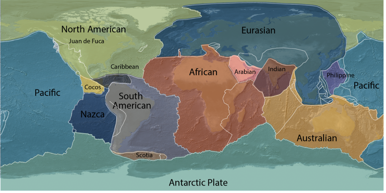
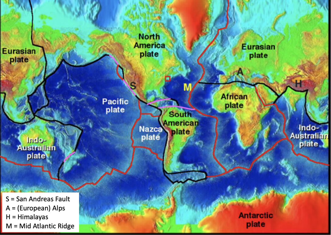
Theory of plate tectonics
Continental drift - A Wegner 1924 - 1930
Marie fark - mapped the structures under the ocean, mid ocean ridges, provided essential evidence for continental drift
Plate tectonics was not valid till the 1960s
Framework for how major landforms are created
What is the lithosphere
Outside of a jaffa - crust is the red part of the jaffa, white part is he lithosphere
Tectonics live in the lithosphere
Crust 0 - 100 km thick
The crust is only a tiny percent of total radius
Rocks in the earth's crust are always less dense than rocks in the mantle
The crust is less dense
Crust is sort of floating on the mantle because it is less dense
Rocks in the uppermost solid mantle rocks are full of iron and magnesium so are much more dense than crust rocks
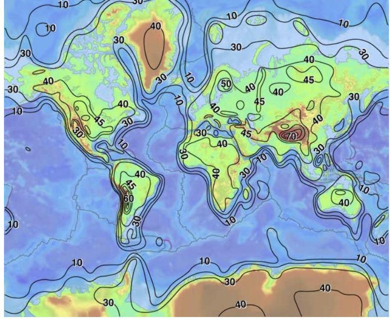
- This is a special kind of map that shows the thickness of the Earth’s crust around the world.
- The lines with numbers on the map are called isopachs. An isopach is a line on a map or diagram beneath which the rocks being studied have the same thickness.
- In other words, an isopach is a type of contour line that connects points of equal thickness.
Asthenosphere
- The asthenosphere lies ~80-200 km beneath the top of the lithosphere.
- The word asthenosphere comes from Greek asthenós, “without strength”.
- The asthenosphere is a mechanically weak layer along which the tectonic plates move. It is part of the upper mantle. - not completely solid
- A small amount (< 1%) of liquid melt in the otherwise solid asthenosphere makes it relatively weak. Allows the plates to move around on top of it
- Rocks at the lithosphere- asthenosphere boundary have a temperature of about 1300 °C. Relative to further down they are under less pressure
The asthenosphere is composed of peridotite, a very dense rock composed mainly of olivine (with some pyroxene). Peridot is gemstone-quality olivine with the formula (Mg, Fe)2SiO4.
Convection is what drives plate tectonics - the mantle convects extremely slowly
Convection in the asthenosphere and mantle
- As the previous movie showed, thermal convection occurs in the asthenosphere and rest of the mantle beneath the lithosphere.
- Mantle convection is the very slow movement (not like the movie!) of mantle rocks caused by convection currents carrying heat from the core towards the crust.
- Hotter mantle rocks are less dense, so they rise and gradually cool.
- Cooler mantle rocks are more dense, so they sink and gradually heat up again.
- Slow convection in the tectonics is very important
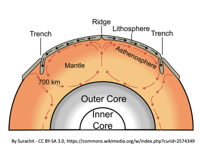
Mantle
- The mantle is one of the 4 major parts of the Earth (crust, mantle, outer core, inner core).
- In geology, we care about rocks and tectonics, natural hazards so we have two more important concepts: lithosphere (crust + uppermost solid mantle) and asthenosphere (upper partially molten mantle).
- The mantle lies between the liquid outer core and the thin outer crust. Its lower boundary is at ~2900 km depth.
- 84% of the Earth’s volume is the mantle.
- Convection in the mantle is the main cause of plate tectonics.
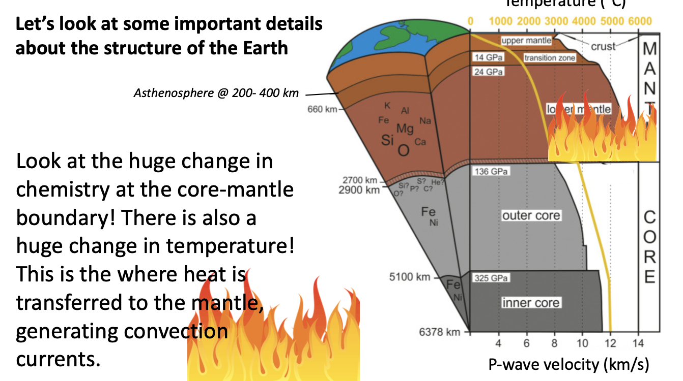
At the core mantle boundary there is a big change in temperature (3000, 4000 degrees) this heat drives convection
Outer core
- The Earth’s outer core is made of liquid iron (Fe) and nickel (Ni), with some lighter elements.
- The outer core is the only liquid layer of the Earth.
- It’s about 2200 km thick.
- The outer core is the site of
violent convection. - This violent convection makes a geodynamo that creates & sustains the Earth’s magnetic field.
- Magnetic field is a key to life on earth
- For a planet to have a geodynamo it must be on an axis, must have fluid that can conduct electricity, this protects solar winds from stripping out atmosphere
Earth’s magnetic field
- The outer core is a geodynamo.
- For a planet to have a geodynamo, it must rotate, it must have a fluid medium in its interior, the fluid must be able to conduct electricity, and energy must be available to sustain convection of the fluid.
- The magnetic field generated by the outer core protects the earth from solar winds (which can strip the atmosphere away) and cosmic waves. So it’s pretty important.
- In addition, interactions between the magnetic field and solar particles create the auroras.
Extreme heat at the outer -core, inner -core boundary
- Theboundarybetweentheliquidoutercoreandsolidinneristhehottestpartof the Earth. It is 5100 km beneath the crust.
- The Temper at the outer-inner core boundary reaches 6000°C,as hot as the surface of the sun. (hottest part of the earth)
Inner core
- The solid inner core is composed mainly of iron.
- The temperature of the inner core is about 5200 °C, but the pressure is so high that the core is solid.
- The pressure at the boundary between the outer core and inner core is 325 GPa. That’s equal to 3,207,500 atmospheres.
- As the Earth slowly cools, the inner core grows by about 1 mm every year (but it grows unevenly).
back to the theory of plate tectonics
- It is the structure and composition of the Earth that makes plate tectonics possible.
- The intense heat at the outer core/mantle boundary generates convection currents.
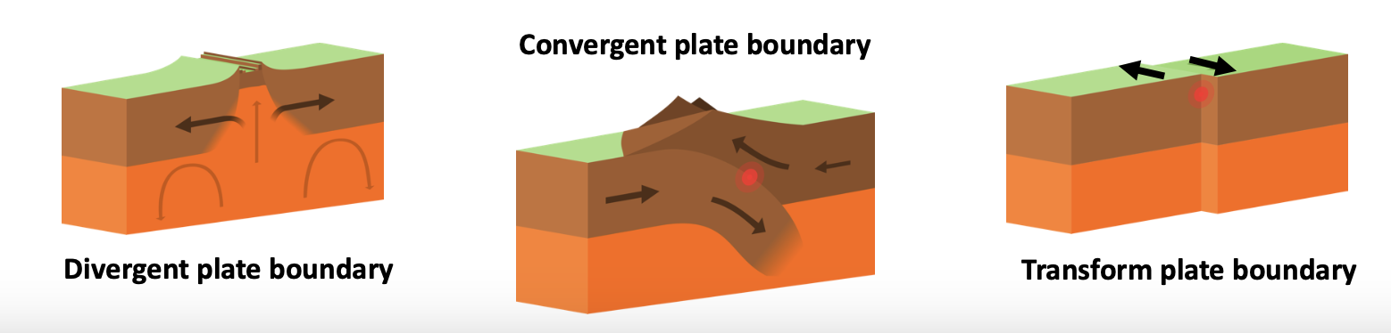
- These convection currents are mostly responsible for two types of plate tectonic boundaries: divergent plate boundaries and convergent plate boundaries.
- A third type of plate boundary, transform plate boundaries, connects the other types together
Recap
- The lithosphere is the (mainly) solid, outer part of the Earth that includes the crust and uppermost part of the mantle.
- The lithosphere sits on top of the asthenosphere, a weak, deformable layer of the mantle composed of peridotite with a small amount of melt.
- The asthenosphere is part of the upper mantle, which transitions into the denser lower mantle.
- Theasthenosphereandlowermantleare convecting as a result of the high temperatures in the Earth’s core.
- TheEarthhasaliquidoutercoreandasolid inner core.
- The Convecting Liquid Outer Core Creates The Earth’s magnetic field.
- ThemainpartsoftheEarth(crust,mantle, outer core, inner core) have important compositional and density differences.
Lecture 9
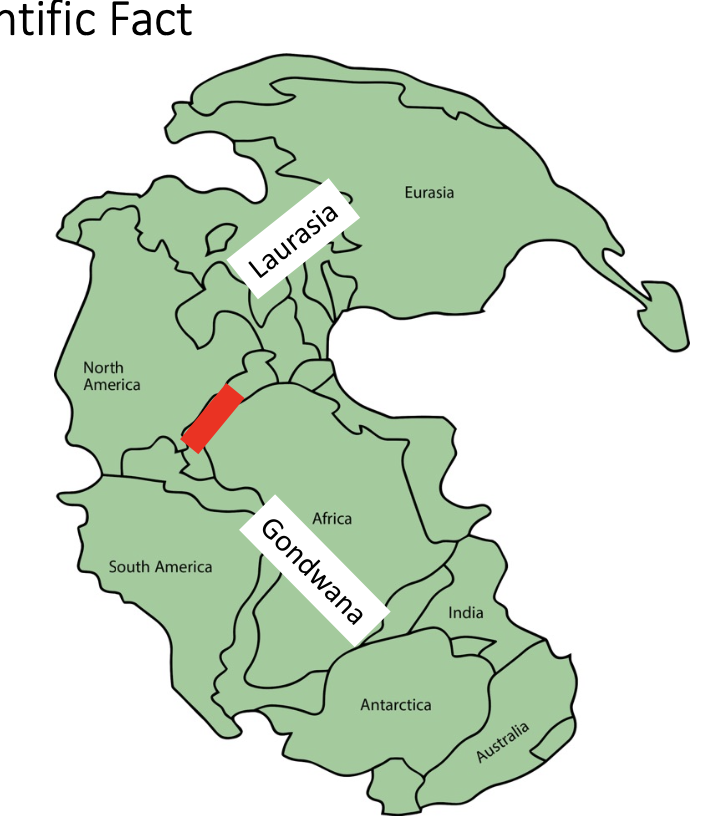
Pangea: A Scientific Fact
- From around 300 to 200 million years ago, the continents were grouped together in the supercontinent called Pangea.
- A supercontinent is a continental landmass that comprises most or all of the Earth’s continental crust (technically, at least 75% of the continental crust present at a given time). As part if a single landmass
- Pangea began to break up in the very late Triassic when rifting (extension) occurred in the central Atlantic Ocean.
- The initial break up formed Laurasia (N America, Greenland, Europe, Asia) and Gondwana (S America, Africa, India, Antarctica, Australia, Zealandia).
- From around 300 to 200 million years ago, the continents were grouped together in the supercontinent called Pangea.
- A supercontinent is a continental landmass that comprises most or all of the Earth’s continental crust (technically, at least 75% of the continental crust present at a given time).
- Pangea began to break up in the very late Triassic when rifting (extension) occurred in the central Atlantic Ocean.
- The initial break up formed Laurasia (N America, Greenland, Europe, Asia) and Gondwana (S America, Africa, India, Antarctica, Australia, Zealandia).
Pangea: Breaking Up
- In the Triassic, the initial break up formed Laurasia (N America, Greenland, Europe, Asia) and Gondwana (S America, Africa, India, Antarctica, Australia, Zealandia).
- In the Jurassic, rifting within Gondwana separated South America + Africa, India, and Antarctica + Australia + Zealandia
- In the Early Cretaceous (150-140 million years ago), Gondwana separated into South America, Africa, India, and Antarctica + Australia + Zealandia
- Zealandia didn’t separate from Australia until the Tasman Sea opened 85 million years ago.
- And Australia didn’t completely separate from Antarctica until around 33 million years ago.
Why did Laurentia and Gondwana Break Up?
- Going back to the last lecture, the continents broke up because of convection in the mantle (heat flow from the core to the lithosphere).
- We already learned that convection is one of the main drivers of plate tectonics.
- An upwelling of heat underneath continental crust causes stretching and thinning. It also creates magma.
- Eventually, a rift forms. A rift is a divergent plate boundary, a plate boundary where two plates are moving away from each other.
- Mid ocean ridge is very important for divergent pate boundaries
Divergent Plate Boundaries
- There are two types of rifts: continental rifts (on continental crust) and mid-ocean ridges (where new oceanic crust forms)
- During continental break up, first a rift forms underneath the continent. This is the syn-rift stage.
- The continent extends, and the continental lithosphere gets thinner.
- What is continental crust?
- Continental crust is composed of relatively less dense elements such as Na, K, Ca, Si, Al, and O.
- The most common minerals in continental crust are quartz and feldspar.
- The density of quartz is 2.65 g/cm3
- The density of feldspar is 2.56 g/cm3
- The density of granite is between 2.6 and 2.75 g/cm3.
- Zelandia was attached to australia then there was mantle dwelling the riffting continued there is a new oceanic crust that is mostly just basalt and is quite thin
Divergent Plate Boundaries
- The end of the syn-rift stage is marked by the creation of oceanic crust along the axis of the rift.
- During the post-rift stage, the rift has been created.
- But a new oceanic crust is still being created at a mid-ocean ridge and the continents continue to move apart.
- What is oceanic crust? Newly solidified magma
- Oceanic crust is composed of relatively more dense elements such as Mg, Fe, Ca, Si, Al and O.
- That’s because oceanic crust is formed from magma coming from the mantle!
- The most common minerals in oceanic crust are olivine, pyroxene, and amphibole.
- The density of olivine is 3.27 g/cm3
- The density of pyroxene is 3.52 g/cm3
- The density of basalt & gabbro is between 2.7 and 3.5 g/cm3. These are the most common rocks in oceanic crust.
- Granite is the typical make up of crust
- Oceanic crust caused from a volcano eruption is basalt
- Oceanic crust is more dense
Continental Crust vs. Oceanic Crust
You all noticed that the crust was thickest on continents and thinnest under the oceans.
- This is true!
- Average continental crust is 35-
40 km thick. - Average oceanic crust is 6-10 km thick.
- Average continental crust (35-40 km thick) is thicker than the oceanic crust (6-10 km thick).
- AND the average density of continental crust (2.7 g/cm3) is less than the average density of the oceanic crust (3.0 g/cm3).
- So when a tectonic plate composed of oceanic crust collides with a tectonic plate composed of continental crust, the plate composed of oceanic crust “loses.” In a way, it’s destroyed. (subducts under the continental crust plate) continental crust will never subduct
- Average continental crust is more thick but less dense than oceanic crust
- Subduction occurs at a convergent plate boundary (moving toward each other)
Convergent Plate Boundaries
- The tectonic plate carrying thinner, denser oceanic crust undergoes subduction.
- Subduction occurs at convergent plate boundaries, a tectonic plate boundary where two plates are moving towards each other.
- During subduction, the oceanic lithosphere sinks into the mantle beneath an overriding tectonic plate (composed of either continental crust or older/thicker oceanic crust).
- We call this type of plate boundary a subduction zone.
- At convergent plate boundaries where both tectonic plates are composed of lithosphere with continental crust, subduction cannot happen.
- Continental crust is never more dense than the mantle.
- Instead, collision occurs at these types of convergent plate boundaries.
- Collision results in the continental crust getting thicker and in mountain ranges.
- The Himalayas were built by the collision of the Indian and Eurasian continents.
Transform Plate Boundaries
- Transform plate boundaries are the third main type of plate boundary.
- At transform plate boundaries, two plates slide past each other.
- At transform plate boundaries, plates are not created (like divergent plate boundaries) or destroyed (like at subduction zones, a type of convergent plate boundary).
- Instead, the plates slide past each other to transform faults.
- Faults are fractures across which displacement (movement) has occurred. There are several types.
- The alpine plate in NZ is a transform boundary
3 Main Types of Plate Boundaries
Divergent Plate Boundaries are plate boundaries defined by two plates moving apart (“rift”). In the post- rift stage, a new oceanic crust forms at a mid-ocean ridge. Rifts can fail during the syn-rift stage (before a mid-ocean ridge forms).
Convergent Plate Boundaries are plate boundaries where two plates are moving towards each other. At subduction zones, the oceanic lithosphere sinks into the mantle beneath an overriding plate. At collisional plate boundaries, the continental crust gets thicker and mountains form.
Transform Plate Boundaries are plate boundaries where two plates slide past each other on a fault. They can occur in oceanic or continental lithosphere. Plates are not created or destroyed.
- The theory of plate tectonics describes the motions of the lithosphere
- According to the theory, plate tectonic processes do not cause significant deformation of the interior parts of tectonic plates.
- Instead, most of the deformation of the tectonic plates is concentrated in belts 10s to 100s of km wide along plate boundaries.
- In other words, almost all of the action occurs @ a plate boundary, which is the boundary between two or more tectonic plates.
- Plates can interact at plate boundaries by rafting or moving apart
- The false colours correspond to relative elevation, with blue being lowest and red/violet being highest.
- The types of plate boundaries are also colour coded:
- Red = divergent
- Black = convergent
- Pink = transform
Earthquakes and volcanoes occur predominantly at convergent and transform plate boundaries. They are especially common along the convergent and transform plate boundaries that surround the Pacific. Hence the phrase “Pacific Ring of Fire”.
- Not just subduction zones but also active volcanoes
- No earthquakes and volcanoes in the riffs because there is lots of mantle upwelling and heat flow that takes a long time to cool down - hot crust doesn’t have earthquakes because it will flow, when it cools it can break to generate a seismic wave for an earthquake
Most of the energy released in an earthquake is on a subduction zone
Sizemac gap - no recorded earthquakes, likely to be an earthquake sometime in the future
Recap
- Pangea is the most recent supercontinent to have formed on Earth. A supercontinent is a continental landmass that comprises at least 75% of the continental crust present at a given time.
- There are two main types of crust in the lithosphere: continental crust and oceanic crust. Continental crust is thicker than oceanic crust, and continental crust has a lower average density.
- There are three main types of plate boundaries: divergent, convergent and transform.
- There is a concentration of deformation (and geohazards!) along plate boundaries.
Subductionzone:atypeofconvergentplateboundarywhereoneplatesubductsbeneath another plate. The subducting plate descends into the mantle.
• Trench:along,narrowdepressionintheseafloorthatformswhereonetectonicplate subducts beneath another tectonic plate. A trench is part of a subduction zone.
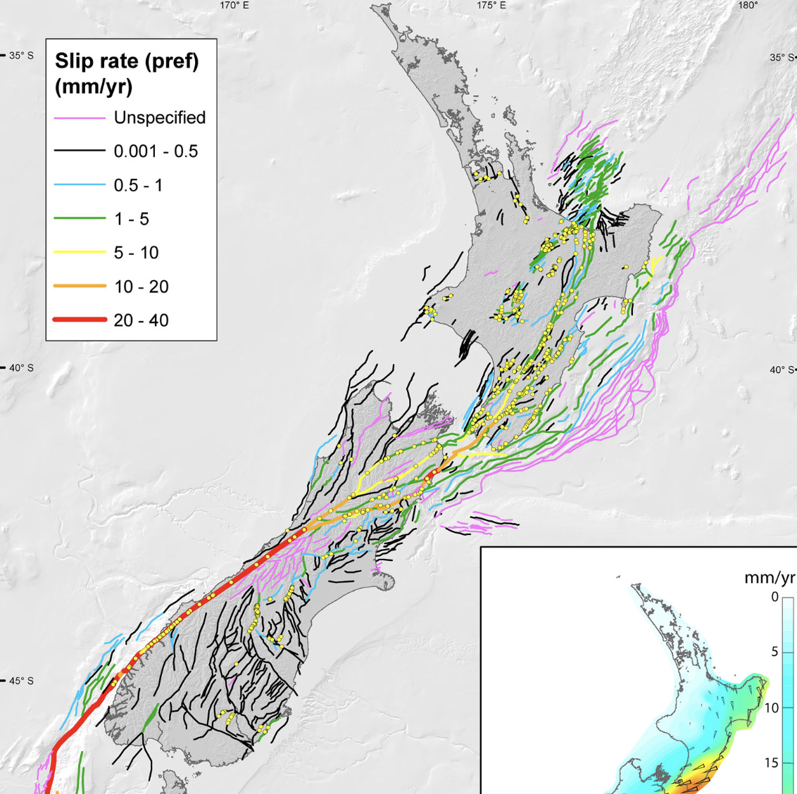
Active faults and the plate boundary in New Zealand
• ~70% of Australian-Pacific plate motion is localised on the principal plate boundary faults
• Remaining motion localised on other faults that are found throughout New Zealand
• Plate Boundary Is A Region,not a line. Not all the faulting that is associated with NZ happens at the boundary so we can’t say that all the movement happens at the boundary - defamation happens all over the south and north island due to the zone of the boundary
- Australian plate is subducting below pacific plate
- No back-arc rift and volcanism, no volcanos associate with the subduction zone
- Near vertical subduction zone in central fiordland and deep seismicity (150km)
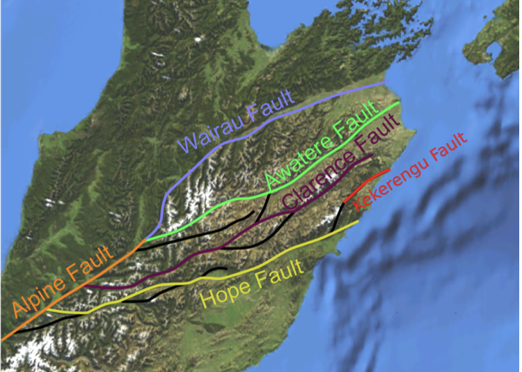
- Principle plate boundary fault on central south island (70% plate motion)
- Mostly a transform fault, but it also has some uplift creating the southern alps
In the north, pacific plate subducting under australian
In the middle, a transform fault
In the south, australian plate subducting under pacific plate
Southern alps are a young mountain range - alpine fault is complicated at the northern end
Alpine fault is important - accommodates most of the movement, fault moves at a convergent
Alpine fault controls the weather by creating the mountains, blocking wind and moisture
The west coast gets hit with all the rain that is resulted from the moisture
North end of the alpine fault - neer lewis pass, alpine fault transfers movement to the marlborough fault system
- In northern South Island, the plate boundary is actually 4 NE-SW major strike-slip faults
- These faults have accommodated a majority of plate boundary motion for 25 million years.
Hikurangi subduction zone
- Subduction of pacific plate below the australian plate
- NZs largest fault
- Under a lot of the north island, because of this ca generate bigger earthquakes
- Faults that are there but you can't see them
North island dextral fault belt
- Set of strike - slip faults in continental crust on the australian plate
- Overlying the Hikurangi subduction zone
- The Wellington fault is accommodating all the side to side motion on the plate boundary
Taupo subduction zone
- Creating a lot of magma - magmatic arc
- Caused by melting of the pacific plate that is subducting
An earthquake is what happens when two parts of the lithosphere suddenly slip pat each other, releasing stored energy as seismic waves
A fault is (quasi)planar structure across which displacement has occurred
Earthquake hypocentre, the point within the earth where the earthquake originates
Elastic Rebound Theory
- Elastic rebound theory states that elastic (recoverable) strain gradually accumulates on either side of a locked fault between EQs (inter seismically).
- Interseismic is the word that we use for the time between earthquakes.
- When the strain exceeds the fault’s strength, stored strain energy is released by rapid (localised) displacement along the fault in an earthquake (coseismically).
- Coseismic is the word we use to describe what happens during an earthquake.
- After the earthquake (postseismically), the rocks on either side of the fault return to their original (unstrained) state.
- Postseismic is the word we use to describe what happens after an earthquake. It usually covers the time immediately after the earthquake until around 10 years later.
- The seismic (earthquake) cycle then repeats.
- The seismic cycle is a concept used to study and describe events that happen before, during and after an earthquake.
Recap
- In this lecture, we toured the types of plate boundaries in New Zealand, including the Puysegur Subduction Zone, Alpine Fault, Marlborough Fault System, and Hikurangi Subduction Zone.
- We also discussed the North Island Dextral Fault Belt (where VUW is) and the Taupō Volcanic Zone.
- Most of the relative motion between the Australian and Pacific plates is accommodated by movement during earthquakes.
- An earthquake is what happens when two Parts Of The lithosphere suddenly slip past each other, releasing stored energy as seismic waves.
- The seismic cycle is a concept used to study and describe events that happen before, during and after an earthquake.
Earthquakes and hazards
1906 San Francisco EQ
- 18 April 1906, Mw 7.9 earthquake on the San Andreas (transform) fault
- Destroyed over 80% of San Francisco, with over 3000 fatalities
- EQ caused by rupture of 500 km of the San Andreas Fault
- The first natural disaster of its magnitude is to be documented by photos and motion pictures.
- Inspired science of seismology
Some OG’s (original geologists) and why they are important
- The 1906 San Francisco EQ had a profound effect on the science of earthquakes
- Recognized as the first geomorphologist, G. K. Gilbert carefully documented the effects of the earthquake on the landscape and infrastructure.
- At the same time, geophysicist Harry Field Reid studied what happened to California before, during, and after the 1906 EQ.
- Reid found that the ground surface bent 3.2 m around the San Andreas Fault before the EQ!
- He proposed the theory that is the foundation for earthquake science: the elastic rebound theory.
Elastic Rebound Theory
- Elastic rebound theory states that elastic (recoverable) strain gradually accumulates on either side of a locked fault between EQs (interseismically).
- Interseismic is the word that we use for the time between earthquakes.
- When the strain exceeds the fault’s strength, stored strain energy is released by rapid (localized) displacement along the fault in an earthquake (coseismically).
- Strain energy - kinetic energy
- Coseismic is the word we use to describe what happens during an earthquake.
- After the earthquake (postseismically), the rocks on either side of the fault return to their original (unstrained) state.
- Postseismic is the word we use to describe what happens after an earthquake. It usually covers the time immediately after the earthquake until around 10 years later.
- The seismic (earthquake) cycle then repeats.
Biggest earthquakes start in continental crust at 300 degrees c
Types of Earthquakes
Differentstressstatesproduce different styles of faulting.
- Stressisanotherwordforpressure
- Stress=Force/Area
- 3maintypesoffaults: Normal, Strike-Slip, and Reverse
- Distinctstressstatesareassociated with each type of faulting
- Thestressstateisdeterminedbythe orientation and (relative) magnitude of the 3 principal stresses (we use the Greek letter s for stress)
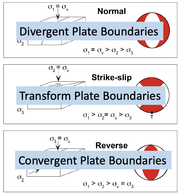
Normal fault - pulls apart
Transform - moving side to side
Convergent - one block moves up and over the top
How we (used to) quantify earthquakes: Local Magnitude ML
- Local magnitude (ML) “Richter Scale”: a measurement made by comparing the amplitude (A) of shaking recorded by a seismometer with the amplitude (A0) of a reference event.
- The local magnitude is calculated as: ML= logA – logA0(d)
- This calculation was done once the distance to the hypocenter (d) is estimated using the difference in S- wave and P-wave arrival times.
- How? P-waves travel faster than S- waves, so the difference in their arrival times is the distance to the hypocentre.
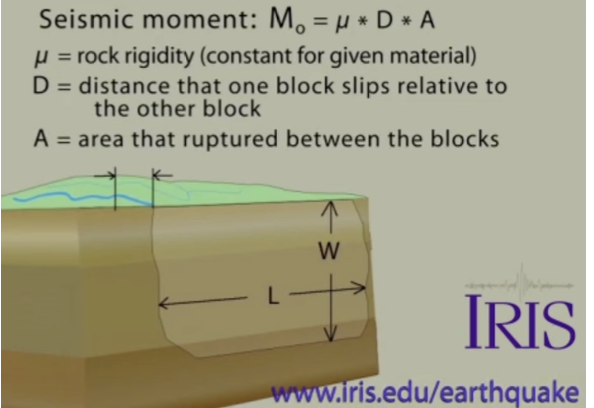
How we quantify earthquakes today: Moment Magnitude Mw
- Today, seismologists use information recorded by seismometers to calculate seismic moments.
- Seismic moment (M0) is measured in units of Nm. It is a better estimate of energy released than local magnitude.
- And it’s comparable at different places around the globe!
- Seismic moment (M0) is the product of the shear modulus (rigidity) (μ), rupture area (A), & average displacement (D):
- M0 = μAD, where μ is commonly taken as 30 GPa for the crust.
- Then, they use seismic moment to calculate Moment magnitude (Mw): Mw = (2/3)logM0 – 10.7
P waves travel faster than s waves
Sdismac moment goes into moment magnatute
- Can be compared all over the world
- Scale does not run out - can measure any level of earthquake
Seismometers & Seismograms
- This figure, from your textbook, shows a seismometer.
- A seismometer is an instrument that records signals (shaking) generated by earthquakes, volcanic eruptions, and explosions.
- A seismometer can record the direction, intensity and duration of the shaking.
- In the old days, the recordings were analogue: on seismograms.
Wave that arrives first is p wave - time that goes by before s wave comes the further away thwy are
S wave cause mire shaking - amplitude goes up
Foundation for early warning signals
Seismic Waves: P Waves
- When an earthquake happens, faults move and energy is released as seismic waves.
- Seismic waves are actually elastic body waves. There are two main types of elastic body waves.
- P waves are primary (or pressure) waves.
- P waves travel through gases, liquids, and solids and are the first waves to arrive at a site/seismograph.
- P waves travel by alternately compressing and expanding material parallel to the direction they are propagating.
Seismic Waves: S Waves
- The other main type of body wave is S waves, secondary (or shear) waves.
- S waves can only travel through solids.
- They are the second waves to arrive at a site/seismograph.
- S waves travel by causing material to move back and forth perpendicular to the direction that they are travelling.
- This is important: S waves cause higher amplitude shaking when they arrive at a site.
Seismic waves: surface waves
- You may have been surprised to see a third type of seismic wave in the movie: (elastic) surface waves.
- The last waves to arrive at a site are surface waves. They only travel through solids.
- There are two main types.
- Love waves propagate by moving material horizontally perpendicular to the travel direction. Very destructive.
- Rayleigh waves propagate by moving material elliptically (“ground roll”).
The Modified Mercalli Intensity Scale
- Modified Mercalli (MM) Intensity Scale: a scale that characterizes the intensity of an earthquake at a location by considering the effects of the shaking on people, manmade structures, and the landscape. Particularly useful for quantifying the distant effects of earthquakes.
- Isoseismal: lines on a map connecting places where an earthquake was experienced with equal strength or intensity.
- The largest intensity occurs at the epicentral region, usually along/parallel to the EQ fault.
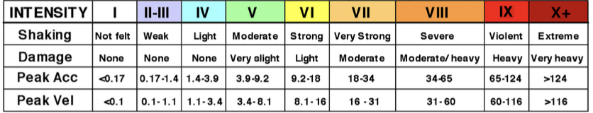
- Shaking decreases with distance away from the fault that generated the earthquake
Seismic (Earthquake) hazards
- The MM Scale is the best scale we have to characterize the cumulative (overall) effect of earthquake hazards.
- Seismic hazards, also referred to as earthquake hazards, are any physical phenomena associated with an earthquake that have the potential to produce loss of life, property, or income. - Encyclopedia of Solid Earth Geophysics
- The primary seismic hazards are ground shaking and permanent ground displacements (surface rupture hazard).
Secondary Seismic Hazards
- Secondary seismic hazards include tsunamis, landslides, soil liquefaction and floods.
- The 26 December 2004 Mw 9.1 Sumatra- Andaman Earthquake occurred along the Sunda subduction zone (megathrust) fault.
- The EQ rupture propagated >1200 km
- Average fault displacement (slip) = 10 m
- Fault slip at the trench = tsunami
- The earthquake + tsunami resulted in >230,000 fatalities in multiple countries.
- Indonesia, Sri Lanka, India, & Thailand suffered the highest losses.
Natural hazards vs. Natural disasters
• Natural hazards are atmospheric, water-related, or geophysical processes or phenomena that may negatively impact human life, property, or other parts of the environment.
• Natural disasters are hazardous events in which people, cities, and/or regions are overwhelmed by environmental conditions that exceed their capacity to cope.
• Today, disaster studies researchers view natural disasters as fundamentally linked to social and economic factors that leave people and populations vulnerable.
Disaster Risk Reduction
Risk= Hazard× (Vulnerability÷ Capacity)
In this equation, hazard is a quantification of the characteristics of
the event (i.e., maximum Mw) and its probability of occurrence (i.e., 10% in the next 50 years).
Vulnerability is the degree to which the population or environment exposed to the hazard is susceptible to the hazard's effects.
Capacity is the ability of the people (or environment) to cope, withstand and recover from the impacts of the hazard.
With research, we (scientists and engineers) can better quantify the
hazard. Together, we (scientists, engineers, politicians, communities) can reduce vulnerability and increase capacity.
Recap
- In today’s lecture, I pulled together what we’ve learned about plate tectonics theory and elastic rebound theory.
- That is, we explored the why and how of earthquakes, the phenomenon that occurs when two parts of the lithosphere suddenly slip past each other, releasing stored energy as seismic waves.
- We talked about how earthquakes are measured, specifically what seismic moment is and how it’s used to calculate moment magnitude (Mw).
- We also talked about how the Modified Mercalli Intensity Scale characterizes the intensity of an earthquake at a location.
- We talked about seismic (earthquake) hazards and the difference between primary and secondary hazards.
- Finally, we talked about how to calculate the risk posed by natural hazards.
Volcanoes - global and planetary perspective
Volcanoes are a mechanism for heat and mass transfer from Earth’s interior
- Mantle (solid) but convecting
- Outer core (Fe+Ni, Liquid)
- Inner core (Fe, solid)
Heat in earth’s surface comes from
- Primordial (core)
- Radiogenic (mantle)
Priormital heat is leftover from the creation of the earth. Eventually, it will delete Makes up half of earths heat budget
Radiogenic heat cones from the mantle, are continually being replenished, and another half of the heat budget
Conduction happens between the element and the bottom of the pot
Conduction – Diffusive transfer of energy from one body to another (inefficient, in the inner core)
Convection – Transfer of energy by fluid motion combined with diffusion (efficient, in outer core and mantle)
Advection – Transfer of energy by fluid motion without diffusion (in crust)
Wherever there is a high heat flux, you are near a plate boundary
1,500 active volcanos on earth, highly biased to volcanoes on land that we can see
Divergent margins = mid-ocean ridges
Convergent margins = subduction zones
Interplate = hot spot
Where are volcanoes?
Divergent Margins – Mid-Ocean Ridges
Divergent plate boundaries, or “spreading centres” where plates are moving apart.
As plates spread apart, primitive basaltic (~50% SiO2) magma rises and erupts to fill the gap.
Divergent Margins – Mid-Ocean Ridges
The Mid-Ocean Ridge (MOR) system is like a seam in the Earth’s surface, extending >65,000 km around the globe.
MOR volcanism is the main mechanism by which new crust is formed (e.g., oldest continental crust = 4 billion years; oldest oceanic crust = 200 million years).
The ridge axis is offset by many transform faults, and its shape is controlled by the spreading rate (e.g., Mid-Atlantic ~2.5 cm/year, East Pacific Rise ~20 cm/year)
Divergent Margins – Mid-Ocean Ridges
Volcanism is generally effusive (not explosive), producing voluminous basaltic lava flows and pillow lavas Sheet lavas
Associated with other types of activity (not strictly volcanic), hydrothermal circulation through the ridge system causes black smokers
Divergent margins - mid-ocean ridges
Most of the mid-ocean ridges system is >200m below sea level
Except in Iceland where one goes onshore
Iceland is intensive region of volcanism, with some eruptions being an onshore version of MOR volcanism
The 1783 Laki fissure eruption in Iceland erupted >12 km3 of magma at 1200 °C and killed 1⁄4 of Iceland’s population.
The Reykjanes Peninsula fissures have erupted 4 times since December 2023
Convergent margins - subduction zones
When plates collide, the denser of the two may dive below the other.
Creates a trench, ahead of a volcanic arc, and then a back basin
The subducting slab is subject to heating and dehydration reactions that cause melting.
Melt ascends because of its low density, but only a small amount makes it to the surface
Can create Continental or Island Arcs
Subduction happening around the entire margin of the Pacific Ocean - creates ring of fire
In New Zealand, the Pacific plate is subducting beneath the Australian plate
Creates a Volcanic Arc that includes the Taupo Volcanic Zone and the Kermadec Arc.
Subduction zones generate a wide variety of magma types, ranging from basalt (~50% SiO2) to rhyolite (~75% SiO2)
NZ volcanoes don’t look like a cones because they erupted in the last ice age
Intraplate – Hot Spots
Away from plate boundaries, there are anomalous mantle plumes.
Mantle plumes are regions of particularly hot, upwelling mantle.
Magma generated by the mantle plume rises through the crust to erupt at a “hot spot” on the Earth’s surface.
Tectonic plates continue to move as normal over top of the mantle plume, so the hot spot remains stationary while the plate moves.
Results in island chains. (typically
Hawaiian islands are just a small part of a much larger Hawaiian-emperor seamount chain
At hot spots, you get lots of melting lava, explosion (more like a spray)
Hot spots aren’t only in oceans
- Yellowstone USA is a continental hot spot
- Under the continental crust
- The Magma type is rhyolite and consists of continental setting
- Yellowstone is a supervolcano capable of producing some of the most powerful explosive eruptions on earth
Volcanoes occur at divergent or convergent margins, and sometimes (hot spots) in the middle of these margins