Lecture 8: Plate Tectonics
Earth’s Structure
Inner core (solid with iron)
Outer core (liquid with iron)
Mantle (solid)
Crust (solid)
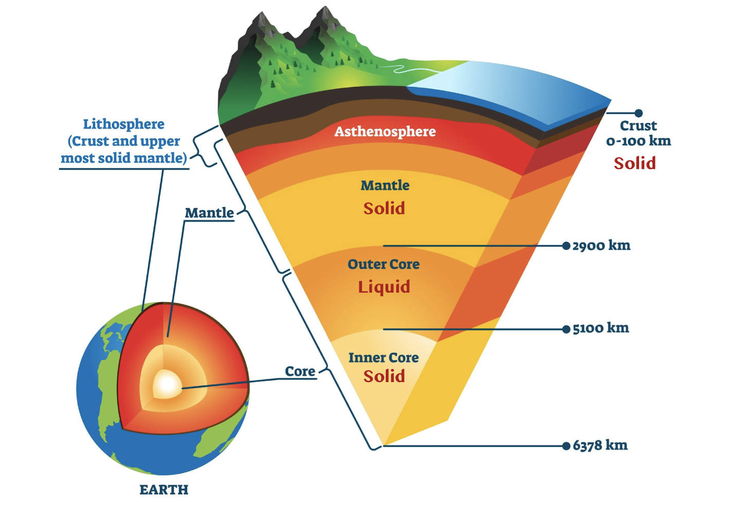
Deepest drill depth: 7.6 miles
Radius of Earth ~3959 miles
How do we know?
Seismic waves
Seismic Waves
Seismic waves: waves of energy released during an earthquake.
Allows us to determine location, thickness, and properties of Earth’s internal zones.
They will change speed and direction.
Focus point: the place inside Earth's crust where an earthquake originates.
Where the energy moves from; where some moves through material.
Body Waves
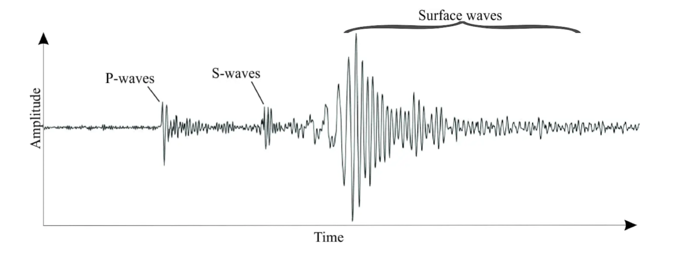
P-Waves (Primary): compression/expansion; rise first; fast; penetrate solids and liquids.
S-Waves (Secondary): perpendicular to direction of motion; rise second; slow; penetrates through solids only.
Surface Waves
Surface waves: large motion waves that travel through outer crust (solid).
Main cause of destruction during earthquakes
Develop whenever P or S waves disturb the surface of the Earth as they emerge from the interior.
P-waves → S-waves → Surface waves
Mohorovicic Discontinuity (Moho Line)
Mohorovicic discontinuity: the boundary between Earth's crust and mantle; it marks a change in the speed of seismic waves.
When seismic waves come into contact with a material that has a different density, they bend (refract). If they move from a material with higher velocity to one with lower velocity, they slow down.
Shadow Zones
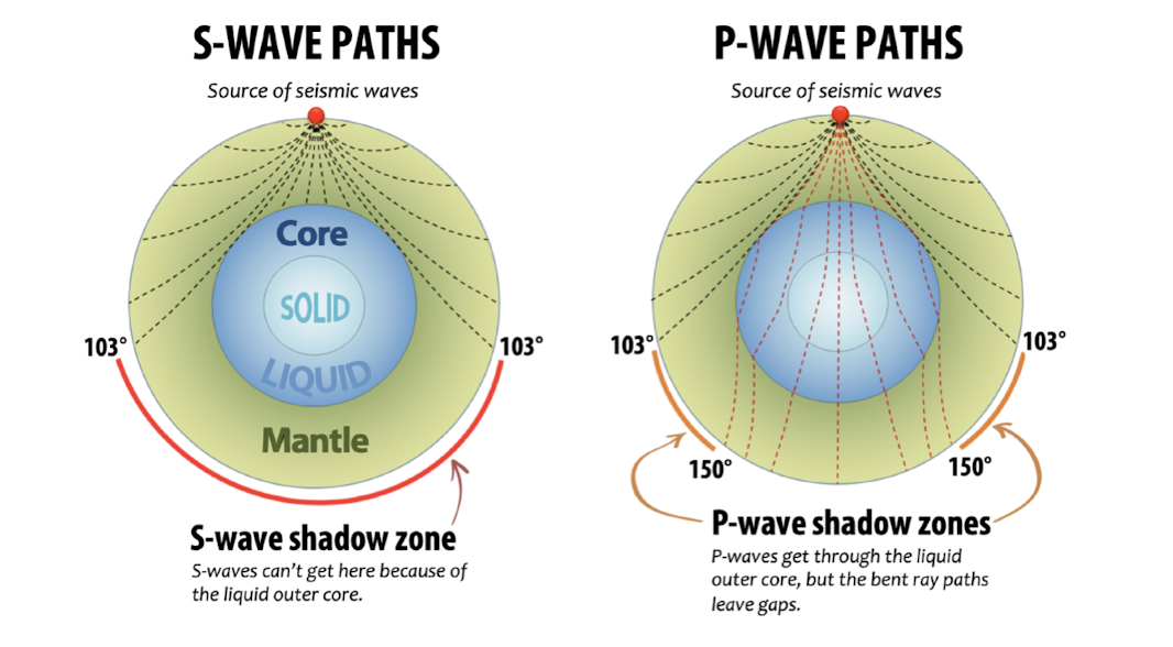
Shadow zones: areas on Earth's surface where seismic waves from an earthquake are not detected; occur because seismic waves are refracted and reflected by different layers within the Earth, such as the core and mantle.
Speed at which waves travel depends on chemical/physical condition of medium.
P waves can penetrate solids and liquids
S waves can only penetrate solids
Existence of shadow zones suggest liquid outer core.
Evidence for a Metallic Core
Inner core (solid)
Earth’s density is 5.5 grams/cm³ (gcc), average density of surface rocks in lighter.
gcc = grams per cubic centimeter
To achieve Earth’s density, mantle rock must be ~4.5 gcc and the core must be ~10.7 gcc.
Under the extreme pressure in the core, iron mixed with nickel would have the required high density.
Most iron meteorites consist of metallic iron alloyed with a small percentage of nickel.
Earth has a magnetic field, which requires metallic inner core.
Fe and Mg Rich Mantle
Mantle density ~4.5 gcc
Igneous rocks (like peridotite) indicate the type of material found in the mantle.
Planetary Differentiation
Planetary differentiation: the process by which a planet separates into different layers, such as the core, mantle, and crust, based on the density and composition of its materials.
Different chemical composition
Different densities (denser material towards center, lighter material close to top)
Although solids are difficult to separate, partial or complete melting enables large-scale differentiation.
Full or partial melting must have occurred.
Where Did the Heat Come From?
Collision of matter
Friction, when things collide it produces heat
Matter squeezed into a smaller volume
Decay of radioactive elements
Layers of the Earth
Crust is mostly made of granite for continent; basalt for oceanic
Mantle is mostly of the mineral olivine
Core is mostly iron and some nickel
Lithosphere and asthenosphere refer to strength
Lithosphere: strong, rigid, and cold; includes crust (continental and oceanic) and part of the upper mantle.
Asthenosphere: weak, hot, and ductile below lithosphere that flows plastically (like putty); creates the movement of our plates.
History of Plate Tectonics
Large Scale Surface Features
Mountains and ocean seafloor
Compressional settings: tectonic plates collide, causing one plate to be forced over or under another, leading to mountain building and crustal deformation.
Andes, Cordillera mountains, Pacific trenches
Extensional settings: tectonic plates move apart, causing the crust to stretch and thin, often leading to rift valleys and volcanic activity.
East Africa Valley, ocean ridges
Strike-slip settings: tectonic plates slide past each other horizontally along a fault, leading to lateral displacement without significant vertical movement.
San Andreas Fault, Anatolian Faults, offset of ocean ridges
Alfred Wegener
German meteorologist
Used the similarity of coast lines to propose a past supercontinent
Proposed hypothesis of Continental Drift
There were others.
Coined the term Pangea
Pangea: supercontinent; means “all of earth”
Evidence for Continental Drift
Geographic fit: continents fit like puzzle pieces
Glaciers striations (and deposits): grooves in the same direction from deposit sediments on the side of glaciers.
Present day striations (and deposits): areas that would have been covered by glaciers in the past that have grooves that would align when putting pieces of land together (Pangea Glacier Reconstruction).
Distribution of climatic belts: ancient climatic zones, such as polar or tropical regions, were once aligned differently.
Fossil distribution: identical or similar fossils are found on widely separated continents.
Problems with Wegener’s Theory
Had evidence, but didn’t understand how it happened.
His work was dismissed.
Evidence was circumstantial and inconclusive; suggested scientifically unaccepted mechanisms (or causes) of continental drift.
Centrifugal effects of Earth’s spin
Tidal forces from sun and moon move continents
Wobble of Earth’s axis
Arthur Holmes
Hypothesized convection currents in the mantle as a mechanism for continental drift.
Radioactivity was key; radioactive decay causes Earth’s interior to be hot enough to cause convection.
Observations not available to test his hypothesis
Bathymetry
Bathymetry: the measurement of ocean floor topography
Echo-sounding (sonar) allowed rapid seafloor mapping
Sounds move through liquids; sonar used sound waves to detect objects underwater
The Ocean Floor
A mid-ocean mountain range runs through every ocean
Deep-ocean trenches occur near volcanic island chains
Submarine volcanoes poke up from the ocean floor
Huge fracture zones segment the mid-ocean ridge
Paleomagnetism
Paleo- means ancient
Magnetism means opposites attract
Earth’s Magnetic Field
Circulation of liquid alloy in outer core generates a magnetic field
Dipole: two ends of opposite polarity
Paleomagnetism
Paleomagnetism: fossil magnetism; created by Earth’s magnetic field when rocks formed
Iron (Fe) minerals in rock preserve information
In hot magma, thermal energy of atoms is very high (no magnetism)
As magma cools, irons forms, align themselves with the field, and becomes solid, preserving the direction of the earth’s magnetic field.
Apparent Polar Wandering (APW)
Perceived movement of Earth’s paleomagnetic poles relatives to a continent.
Hypothesis 1: Continents remained stationary, magnetic poles migrating
Prediction: APWs derived from different continents should overlap
Observation: FALSE
Hypothesis 2: Magnetic poles more or less remained stationary, continents migrating
Prediction: Continents sticking together should have similar APWs
Observation: Europe and N. America have similar APWs during Paleozoic, consistent with existence of a Paleozoic supercontinent (Pangea).
Reversal of Magnetic Field
Earth’s magnetic field is periodically reversed polarity.
Iron-rich magma/lava cool and “lock” during that time.
Our planet’s magnetic field reverses about every 200,000 years on average.
The time between reversals is highly variable.
Last time the Earth’s magnetic field flipped was 780,000 years ago, according to the geologic record of Earth’s polarity.
Plate Boundaries
Himalayan Mountains (Mt. Everest)
Largely caused by the formation, movement, and destruction of large rigid plates.
Similar to the rest of Earth’s surface
Formation began ~50 Ma
Major Conclusions of Plate Tectonics
The lithosphere (outermost shell of Earth) is composed of 13 or more large rigid plates and numerous smaller ones.
The plates move with respect to one another and continents are mobile.
Continents are relatively odd, ocean basins relatively young.
Geologic activity is concentrated along the boundaries between plates.
Tectonic Plate Map
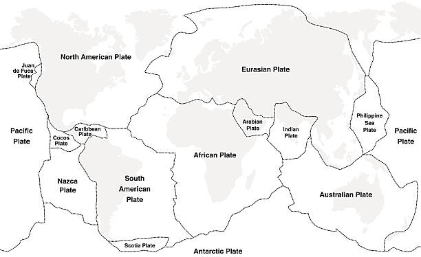
Plate Movement
Earth’s outermost layer comprises plates which move relative to each other.
These movements are now measured by multiple accurate techniques.
Plates with Continental and/or Oceanic Crust
Some plates are mostly oceanic crust.
Others contain both oceanic and continental.
Ocean crust is more dense compared to continental crust.
When these two plates collide, if you have ocean crust collide with continental crust, the denser material is going to subduct and be pushed underneath.
Convection
Heat from the Earth's core warms the mantle, causing the hotter, less dense material to rise towards the surface.
As the material nears the surface, it cools, becomes denser, and sinks back down into the mantle.
This rising and sinking cycle, known as convection currents, continuously moves the mantle material and drives plate tectonics on the Earth's surface.
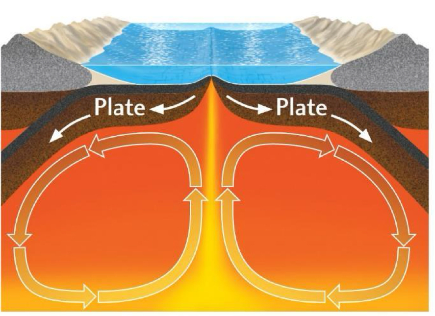
Plate Boundaries
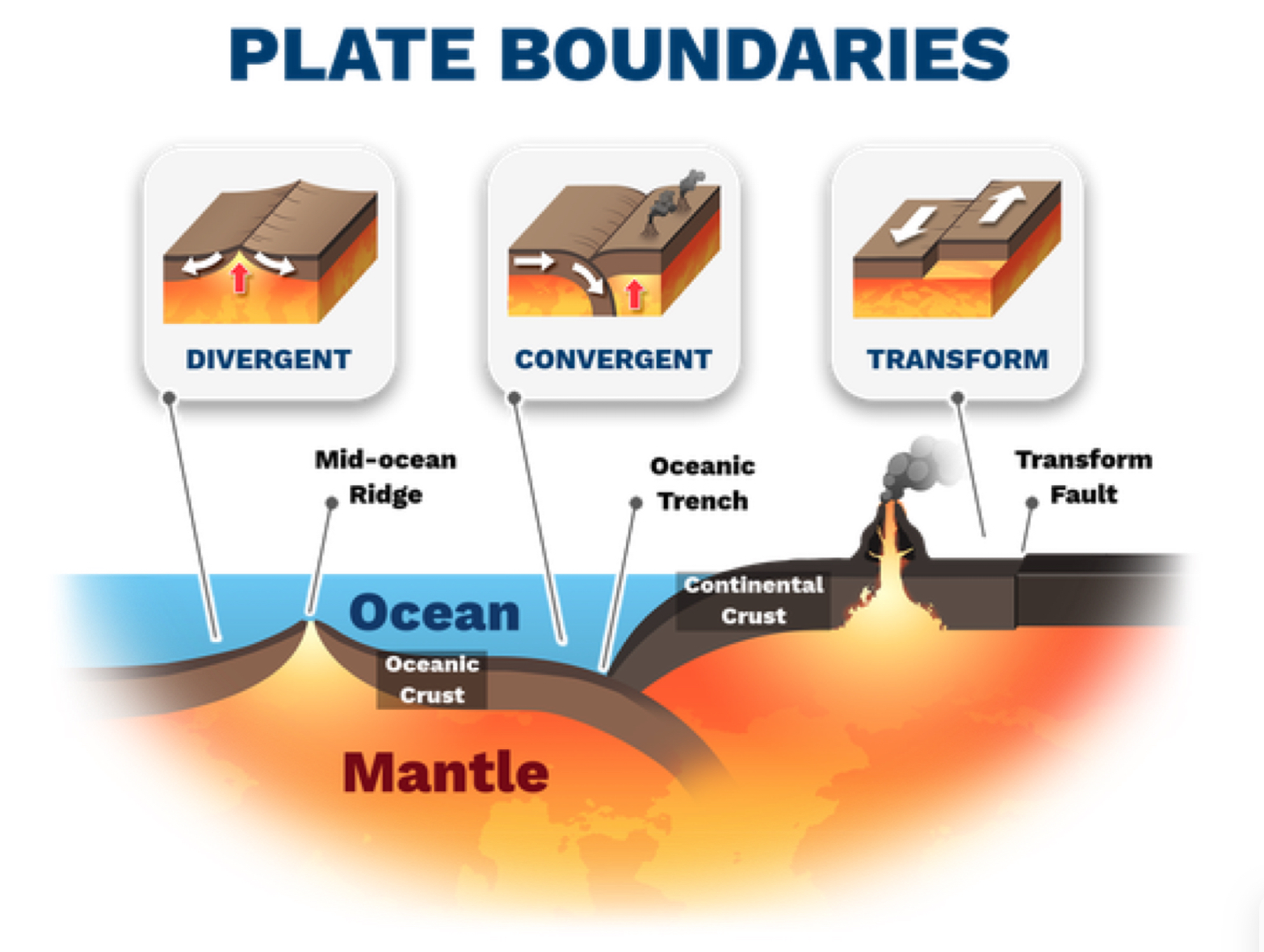
Types of plate boundaries: divergent, convergent, transform
1. Divergent Boundaries
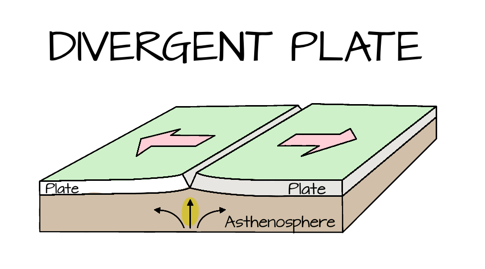
Divergent boundary: where two tectonic plates move apart; tension.
This creates:
Mid-ocean Ridges: Underwater mountain ranges, like the Mid-Atlantic Ridge.
Rift Valleys: Deep valleys on land, like the East African Rift.
Seafloor Spreading: New oceanic crust forms and spreads, expanding the ocean floor.
How to make an ocean:
Continental hot spot and up warping; continental crust is being deformed because hot material is pushing up against crust.
A rift valley forms; done by being stretched apart to form the huge valleys (Ex: East African Rift). We will see basalt.
Proto-oceanic gulf; crust is spread so thin that ocean flow begins, water is coming in.
In final stage, ocean continues to open wider and wider.
Edges of plates gradually sink as the hot oceanic crust shrinks and subsides, forming passive margin wedge.
New crust still forms at mid ocean ridge.
2. Convergent Boundaries (Active Margins)
Convergent boundary: a type of tectonic plate boundary where two plates move towards each other; compression.
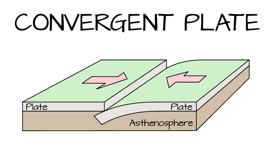
These boundaries can result in:
Continental-Continental Crust results in mountain formation: When two continental plates collide, creating mountain ranges like the Himalayas.
Himalayan type
Oceanic-Continental Crust results in subduction zones: When an oceanic plate collides with a continental plate and is forced underneath it, leading to volcanic activity and the formation of trenches.
Andean type
Oceanic-Oceanic Crust results in island arcs: When two oceanic plates converge, one is subducted, forming volcanic island chains.
Japan type
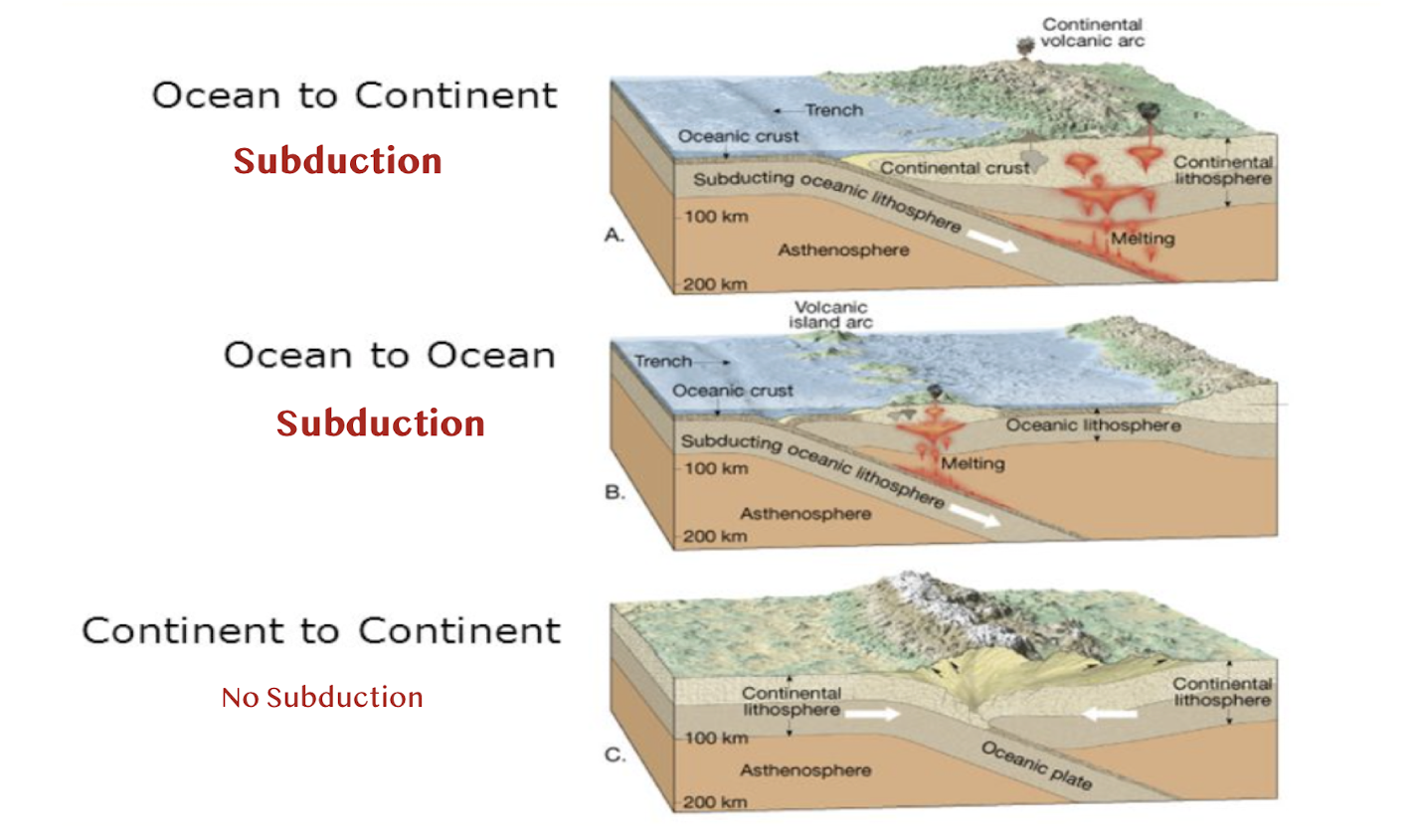
When dense ocean crust goes down into the mantle under continental crust - this is subduction; denser materials sinks down below less dense material.
This does not happen between 2 continental plates because they are less dense and neither will subduct.
Subduction only occurs with oceanic-oceanic and oceanic-continental convergence.
Subduction is characterized by:
Deep earthquakes
Volcanism caused by partial melting of the subducted plate
Trenches
Between 3-10 cm/yr
Accretionary Wedge
Accretionary wedge: a zone where material is scraped off of a subducting plate and compressed into the continental margin.
Material accretes from bottom, so oldest material at TOP, youngest at bottom (reverse of superposition).
Intensely deformed and sheared into a mixture:
Deep-sea turbidities, shales and cherts scraped off top of oceanic plate
Slices of ophiolite from down-going slab- assemblage of rocks made from pieces of the oceanic plate that were transferred onto the continental margin.
Metamorphic blueschists recycled from deeper in trench.
3. Transform Boundaries
Transform boundary: a type of tectonic plate boundary where two plates slide past each other horizontally (lateral); shear stress.
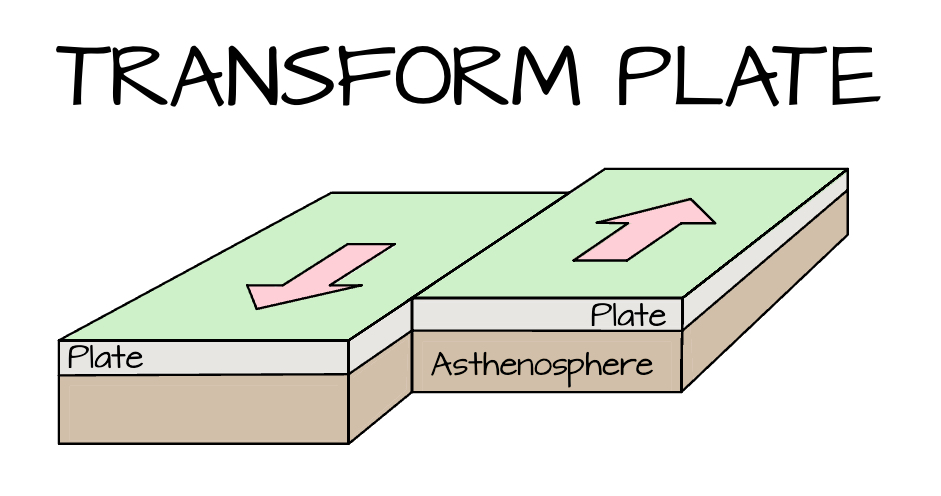
Places on earth’s surface where lateral relative plate motion dictates that crust is neither spreading nor subducting.
Lateral movement accommodates spreading and convergence since plates are brittle.
Produces huge strike-slip faults and shallow earthquakes.
Also found in fracture zones along mid-ocean ridges.
The San Andreas Fault - transform plate boundary
Separating the Pacific plate from the North American plate.
Connects the spreading ridges in the Gulf of California with the Juan de Fuca and Pacific plates off the coast of northern California.
Movement along the San Andreas Fault caused earthquakes.
Hot Spots
Hot spot: an isolated area of voluminous volcanic activity not explained by melting processes at plate boundaries; rising plume of hot material reaches the surface and forms a volcano.
Sourced from anomalously hot parts of the lower mantle.
A second type of mantle upwelling aside from convection currents.
Hawaii - northwest islands are older
Review Questions
What is Earth’s general structure (layers) and what is the evidence of its composition? What is planetary differentiation?
Earth's General Structure (Layers): The Earth is structured in three main layers: the crust (outermost layer), the mantle (beneath the crust), and the core (innermost layer, divider into a liquid outer core and a solid inner core).
Evidence of Its Composition: Evidence includes seismic wave data (showing how waves travel through different layers), rock samples (from drilling and volcanic eruptions), and studies of Earth's magnetic field and gravity.
Planetary Differentiation: The process by which a planet's internal layers separate into distinct regions based on their density, with heavier materials sinking to the core and lighter materials rising to form the crust and mantle.
Who was Alfred Wegener? What did he contribute to the theory of plate tectonics?
Who Was Alfred Wegener?: Alfred Wegener was a German meteorologist and geophysicist known for his pioneering work on the theory of continental drift.
Contribution: Wegener proposed that continents were once joined together in a supercontinent called Pangea and have since drifted apart, laying the groundwork for the modern theory of plate tectonics.
What was some early evidence of plate tectonics?
Fossil Evidence: Similar fossils of plants and animals found on different continents, suggesting they were once connected.
Geological Matching: Matching geological formations and rock types across continents, indicating they were once joined.
Fit of Continents: The jigsaw-like fit of coastlines, such as the eastern coast of South America and the western coast of Africa, suggesting they were once part of a larger landmass.
Paleoclimatic Evidence: Evidence of past climates, such as glacial deposits in now tropical regions, indicating continents were once situated differently.
Who was Authur Holmes? What did he contribute to the theory of plate tectonics?
Who Was Arthur Holmes?: Arthur Holmes was a British geologist who significantly contributed to the study of Earth's structure and the development of plate tectonics. Hypothesized convection currents in the mantle as a mechanism for continental drift.
Contribution: Holmes proposed the idea of mantle convection as a driving force for continental drift, providing a mechanism for the movement of tectonic plates and supporting Wegener's theory.
What are the 3 main types of plate boundaries, what processes occur along them, and what landforms are found along them?
Divergent Boundaries:
Processes: Plates move apart, leading to the formation of new oceanic crust through volcanic activity.
Landforms: Mid-ocean ridges, rift valleys, and volcanic islands.
Convergent Boundaries:
Processes: Plates collide or converge, causing one plate to be subducted beneath the other, leading to mountain building or volcanic activity.
Landforms: Mountain ranges (e.g., Himalayas), deep ocean trenches, and volcanic arcs.
Transform Boundaries:
Processes: Plates slide past each other horizontally, leading to earthquakes and faulting.
Landforms: Fault lines and earthquake-prone regions (e.g., the San Andreas Fault).