Components of GIS
HARDWARE
Computer components from which the system will run
that form the physical framework
Input devices, storage and processor and output devices
TYPICAL GIS WORKSTATION
DUAL MONITORS
Multitasking
Optimal vision and task organization
1st screen: map; 2nd screen: tables and attributes
CPU
GIS is CPU heavy
Overclocking is common in GIS and CPU performances reduces lag
Can be multiple-core processing
Random Access Memory
Temporary memory
Hard Disk Drives
Permanent storage
Store data on spinning magnetic disks
Solid State Drivers (much faster; no moving parts)
GPU
Visualize smoother
Renders multilayered maps and symbology smoothly
Hastens zooming and panning in a map
Help display 3D with ease
Flash Drives
Portable data storage in solid state memory
CD-ROM, DVD and Blu-Ray
Permanent external storage; cannot be unchanged forever
Much slower than flash drives and HDD
SOFTWARE
Computer programs
ArcGIS, QGIS and TerrSet are some of the most popular GIS Software
Common GIS Software
ArcGIS
Requires payment for software licenses
Developed by ESRI
Geomedia
Rival of ArcGIS, previously owned by by Intergraph.
Now Hexagon Geospatial Geomedia
MapInfo Professional
Clear focus in location intelligence
Manifold GIS
Combination of mapping, CAD, DBMS and image processing
TerrSet (formerly IDRISI)
Clark Laboratories more specializes in remote sensing
Plug-ins: Land Change Modeler, Habitat and Biodiversity and Modeler.
QGIS
Open-source software; free use
Available in Windows and MacOS
DATA
Spatially referenced dataset
Data types: geometric data, and attribute data
Geometric
Geographic feature (shape and position)
Two or three-dimensional coordinates which define spatial distribution of points line and areas
Attribute
Describes the properties of a feature
Color, size, and information
Types of Measurement Scales
Nominal Data
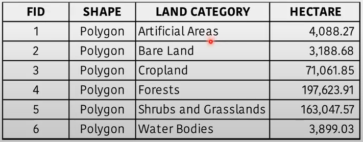
Described as kinds or categories of data such as land cover or soil types]
Ex. land cover: forest, cropland or grass land; soil types: sandy-clay, clay-loam
Ordinal Data
data by ranking relationship
determine position but no establish magnitude or relative proportions
ex. hazard maps: light moderate, and severe
Interval
known interval between values
values on a linear calibrated scale
not relative to a true zero point in time and space
ex. temperature, pH scale
Ratio
Zero: absolute
Ex. population density, covid cases: 0 means there is no case of covid-19
Data Structures
Vector
Vector graphics – vertices and paths
Three basic symbol types – points lines and polygons
Raster
made up of pixels (grid cells)
regular spaced and square
each pixel has its own value or class
“Geographic data is crucial in decision-making” - where to intervene, immediate concern for relocation relative to the path of the typhoons
METHODS & PROCEDURES
Well-designed plans management framework and work flows associating data and procedure.
Models and operating practices are unique and vary based on the objectives set by the organization.
Geographic Approach
Measure
Store Data
Analyze Data
Visualize Data & generate Statistics
Take Actions
GIS applications across many disciplines
Site Selection
Engineering Design
Demographic Analysis
Topographic Analysis
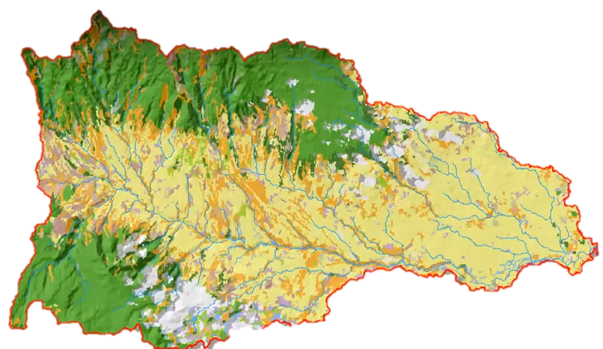
Watershed Analysis
Resources Inventories
Land Management
Network Analysis
Incident Mapping
Spatial Measurement
Corridor Selection
Logistics Routing
Transportation Modeling
Resource Exploration
Facility Management
Geo-process Modeling
Spread and Diffusion
PEOPLE (users)
Involve various tasks: data input, database management, modeling and analysis, output production or system administration
Basic understanding on concepts principles and applications of GIS
Categories of Human Resources
Operational Staff
End user, cartographer, data capturer and potential users
Technical Professional Staff
Analyst, system administrator, programmer, and database administrator
Management Personnel
Manage and quality assurance coordinator
Five fundamental personas of GIS users
Viewer – views and interacts with existing maps
Contributor – create, update and share maps
Analyst – geospatial analysis and visualization and mapping
Curator – supervises the company and authorize maps to be publish
Expert – data scientist, advance and broader knowledge of GIS