🌋 APES Geosphere Unit Study Guide (4.1, 4.2, 4.3, 4.6)
4.1 — Plate Tectonics
Boundaries:
Convergent Boundary: Two plates moving torwards eachother
Subduction: Denser plate moves under the less-dense plate
Can result in mountains, island arcs, earthquakes, and volcanoes
Divergent Boundary: Two plates moving away from each other
Seafloor Spreading: Magma fills space between plates forming rock
Can result in seafloor spreading, rift valleys, volcanoes, and earthquakes
Transform Boundary: Two plates sliding past each other in opposite directions
Can result in earthquakes
Plate Tectonics Map:
Using maps lets us better understand plate tectonics
We can use maps to find locations of volcanoes, island arcs, earthquakes, hot spots, and faults
Earthquakes:
Occur when stress overcomes a locked vault, releasing stored energy
4.2 — Soil Formation & Erosion
Soil formation starts with parent material, and is broken down through weathering. Other particles can also be introduced through deposition. With presence of vegetation and organisms, soil horizons begin to form and nutrients are added to the soil
Soil Horizons
O | Organic Layer (Humus) | Surface litter (ex. leaves, decaying matter) |
A | Topsoil | Mixture of organic materials with minerals |
E | Eluviated | Zone of Leaching, nutrients from upper horizons move to lower horizons |
B | Subsoil | Zone of Accumulation, minerals like iron accumulate |
C | Parent Rock | Partly weathered rock, original material that is broken down to create soil |
R | Bedrock | Unweathered rock base |
Erosion
Soil is very easily washed away by wind and water without vegetation to hold it in place
Erosion negatively impacts water quality
Vegetation with soil can help filter water, but without vegetation this does not happen
4.3 — Soil Composition & Properties
Water Holding Capacity
The maximum amount of water soil can hold under gravity
Retention contributes to land producivity and soil fertility
In farming, soil is more desirable when it can hold water in its pores instead of letting it penetrate further into the crust.
Increased by:
Smaller particles
Organic matter
Loam is the soil type with the highest water retention with an equal amount of small, medium, and large particles
Properties of Soil
Chemical:
pH: How acidic or basic a soil is
Impacts what plants can grow
Can shift easily, acidic soil often made by pollution or acid rain
Cation Exchange: When soil particles attract cations (positively charged ions)
Regulates pH
High cation exchange capacity increases ability to maintain pH and nutrients levels
Physical
Aeration: Ability to take in essentials such as nutrients, water, and oxygen
Good aeration is crucial to support plant life
Soil Compaction: How compacted soil particles are
High compaction can negatively affect porosity, permeability, and aeration
Heavily compacted soil means there is less space for water, air, or other essential nutrients
Biological
Are determined by the organisms and plants that live in it, meaning soil composition and consistency varies based on biome and climate. Species like fungi and bacteria can help develop soil composition in ways other species cannot.
Soil Texture Triangle
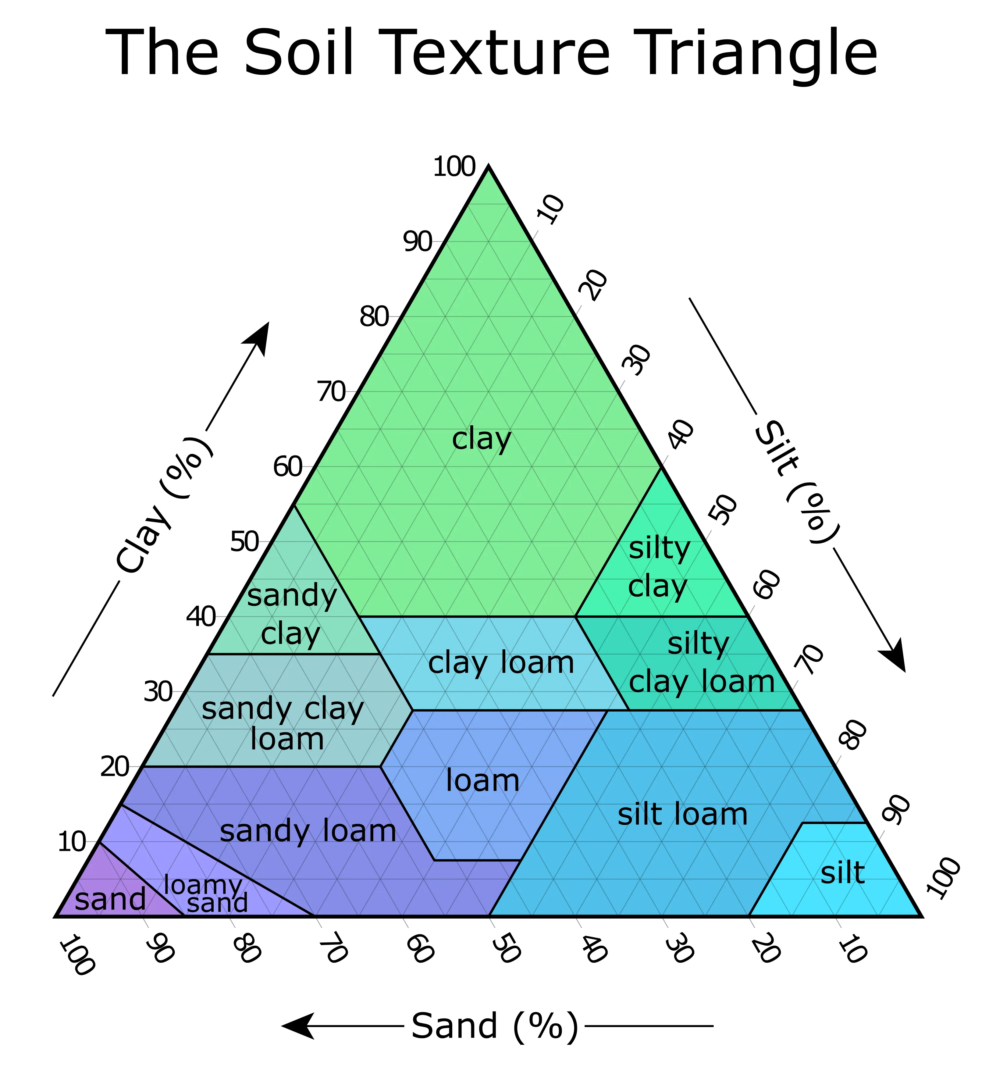
Allows us to identify soil using percentage of clay, silt, and and sand.
The angle of the numbers shows the way the lines run
For example, clay lines run straight across because the clay numbers are written normally
Sand lines run diagonally, down left-to-right, because that’s the way the numbers are oriented
It is used by following the lines to find where they all intersect
For example, 20% clay, 50% sand, and 30% silt would be loam
4.6 — Watersheds
A channel (stream, river) that concentrates runoff (water) to the main discharge point (a large body of water). The discharge point is usually the lowest point in the watershed.
They are usually seperated by ridges or mountains that form the highest part of the watershed.
Headwaters: Beginning of a watershed
Sub-watersheds: Mini watersheds within a larger watershed, but all runoff will eventually discharge into one point
Characteristics:
Size (area) can be a reflection of the amount of runoff and what is created by the runoff (stream, creek, etc.)
Steeper slopes allow water to flow easier
Longer watersheds make water take longer to discharge
The type of soil and vegetation impact the amount of runoff water and can also filter the runoff.