Lecture 3: Meridian Ellipse
Geocentric Reference Ellipsoid - if the reference ellipsoid is an approximation of a global geoid
Local Reference Ellipsoid - if the reference ellipsoid is an approximation of a regional portion of geoid
Curvilinear Coordinate System - refers to orthogonal parametric curves on the surface
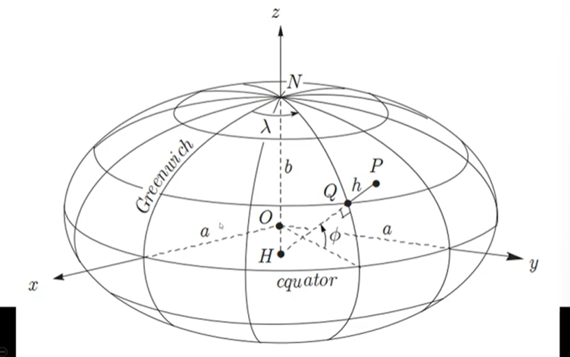
Parametric Curves - curves that are defined by parameters rather than the usual single equation. We use it if we were to describe or illustrate mathematically complex shapes that are not easily explained by functions of x or y.
Parameters of Curvilinear Coordinate System:
Parallels of Latitude - represented by Φ. From equatorial plane and up. They are imaginary horizontal lines drawn parallel to the equator. All points on the same parallel have the same latitude.
Meridians of Longitude - corresponds to λ. They are imaginary vertical lines that run from the North Pole to the South Pole.
They have respective reference planes:
Greenwich Meridian - longitudes measure it from 0° to ±180° wherein the east direction is positive and the west direction is negative. It is important since it tells us where the 0° longitude is. It is the XOZ plane or the origins of longitude.
Equatorial Plane - latitudes measure it from 0° to 90°. North direction is positive and south is negative. It is the XOY plane.
XYZ plane - cartesian coordinate system with O as the point of origin.
Z-axis - minor-axis or the axis of revolution
Positive x-axis passes through the intersection of Greenwich Meridian and Equator.
Positive y-axis is advanced 90° east along the equator
Positive z-axis passes through the north pole of our ellipsoid
Cartesian Equation of Particular Ellipsoid on the Illustration: ((x²+y²)/a²) + z²/b² = 1
a and b are the semi-axis of ellipsoid
a > b
Some Properties of Ellipsoid:
All meridians of longitude in ellipsoid are ellipses with semi-axes, a and b. If you are to intersect any plane on the ellipsoid, passing through or including the north or south pole, their intersection anywhere is ellipses or meridians.
All parallels of latitude in ellipsoid are circles that are created when a plane intersected the ellipsoid horizontally or parallel to equatorial plane.
Great Circle - intersection of the equatorial plane with the ellipsoid because in all created parallels of latitude on the ellipsoid, it has the largest size.
Any other curves on the surface of the ellipse not necessarily coinciding with the z-axis or any axis, their intersection are ellipses.
Why do we use geodetic latitude for geodetic coordinate?
The normal to the ellipsoid closely represents the direction of gravity (plumb line) at that point.
When surveyors or GPS instruments measure position, they use the local vertical direction — which aligns with the ellipsoidal normal, not the center of the Earth.
Therefore, geodetic latitude directly corresponds to how we measure “up” and “down” in the real world.
Ellipsoidal height (h) — the third coordinate — is measured along the ellipsoidal normal.
Therefore, latitude must also be defined with respect to that same normal.
Why is the meridian ellipse important?
The meridian ellipse is crucial in geodesy because:
It defines the curvature of the Earth along a meridian (north–south direction).
It’s used to calculate:
Meridian arc distance — the distance along a meridian between two latitudes
Radius of curvature in the meridian (M)
Geodetic to Cartesian coordinate conversions
Without understanding the meridian ellipse, it’s impossible to accurately represent Earth’s shape for mapping, surveying, or navigation.
Parametric Representation of the Meridian Ellipse
p → horizontal coordinate (distance from rotation axis)
z → vertical coordinate (height above equatorial plane)
Together (p, z) define any point on the meridian ellipse, with the latitude parameter (φ, ψ, or β) determining where that point lies.